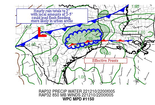
Mesoscale Precipitation Discussion 1150
NWS Weather Prediction Center College Park MD
636 PM EST Sat Dec 10 2022
Areas affected...portions of Southeast TX
Concerning...Heavy rainfall...Flash flooding possible
Valid 102335Z - 110535Z
Summary...Showers and thunderstorms across Southeast TX are
showing an increasing training signature in and around Conroe.
Hourly rain totals to 2" with local amounts of 3-5" are possible
through 06z.
Discussion...Showers and thunderstorms have been increasing in
intensity and coverage as of late west and north of Houston, along
an outflow boundary/convergence axis which is noted in the thermal
pattern and wind observations across southeast TX and southern LA.
Divergence aloft has been sponsored by an upper level shortwave
moving across western TX. More organized activity is moving more
eastward, occasionally colliding with less organized activity
moving more northeast, which is amping up the hourly rain totals.
Precipitable water values are 1.3-1.75" in this region per GPS
data. Inflow at 850 hPa is ~20 kts from the southwest based on
the KPOE and KHGX VAD wind profiles. ML CAPE of 1500-2000 J/kg
exists, per SPC mesoanalyses, with the heart of the instability
pool showing 72-73F dew points. Effective bulk shear of 40 kts is
leading to more organized convective structures normally seen in
HP/high precipitation environments.
As a polar front comes in from the north and the upper level
shortwave approaches from the west, the areal extent of the heavy
rainfall should increase overnight as low-level convergence
increases further. The concern is that training and merging
convection would be capable of hourly rain totals up to 2" or so
with local amounts of 3-5" per the current mesoscale guidance.
While the region has been dry, this degree of rainfall would be
problematic in any urban environments it would occur within.
Thus, flash flooding is expected to be isolated at first but could
become widely scattered towards 06z, particularly if the high end
guidance (HRRR and NAM CONEST) come to pass.
Roth
ATTN...WFO...EWX...FWD...HGX...LCH...SHV...
ATTN...RFC...WGRFC...NWC...
LAT...LON 31279392 30439409 30159510 29769665 29809715
30629702 31149596
Winter time post are almost exclusively focused on the DFW area.
 The posts in this forum are NOT official forecast and should not be used as such. They are just the opinion of the poster and may or may not be backed by sound meteorological data. They are NOT endorsed by any professional institution or