Texas Winter 2024-2025
Moderator: S2k Moderators
Forum rules
 The posts in this forum are NOT official forecast and should not be used as such. They are just the opinion of the poster and may or may not be backed by sound meteorological data. They are NOT endorsed by any professional institution or STORM2K.

The posts in this forum are NOT official forecast and should not be used as such. They are just the opinion of the poster and may or may not be backed by sound meteorological data. They are NOT endorsed by any professional institution or STORM2K.
-
Stratton23
- Category 5

- Posts: 3485
- Joined: Fri Jul 21, 2023 10:59 pm
- Location: Katy, Tx
Re: Texas Winter 2024-2025
Man the 00z GEFS just screams an overrunning ice storm setup in early February , trough out west with arctic air plunging straight down to brownsville, yikes
4 likes

Re: Texas Winter 2024-2025
Stratton23 wrote:Man the 00z GEFS just screams an overrunning ice storm setup in early February , trough out west with arctic air plunging straight down to brownsville, yikes
Looks like the 0z EPS was cold too.
1 likes
-
bubba hotep

- S2K Supporter

- Posts: 6012
- Joined: Wed Dec 28, 2016 1:00 am
- Location: Collin County Texas
Re: Texas Winter 2024-2025
It looks like an active pattern over the next two weeks, with the potential for some cold later in the period.
2 likes
Winter time post are almost exclusively focused on the DFW area.
-
Sambucol2024
- Tropical Storm

- Posts: 103
- Joined: Mon Feb 26, 2024 1:54 pm
Re: Texas Winter 2024-2025
Stratton23 wrote:Man the 00z GEFS just screams an overrunning ice storm setup in early February , trough out west with arctic air plunging straight down to brownsville, yikes
Does it show an ice storm over southeast Texas or most of the state?
0 likes
-
wxman22

- Category 5
- Posts: 1850
- Joined: Mon Jan 30, 2006 12:39 am
- Location: Wichita Falls, TX
- Contact:
Re: Texas Winter 2024-2025
Looks like next weeks storm may cause a pattern change and allow another push south of arctic air. With a SE ridge in place this pattern "screams" ice storm. Feb 3-6th seems to be the timeframe models are showing for this potential.
3 likes


Re: Texas Winter 2024-2025
Seasonal trends looks like it's winning out. Aleutian ridging is consistently leaning towards GOA ridge from long to medium to short range. That would bode well for cold deliverance. East coast ridge will help, SE ridge will try though.


5 likes
The above post and any post by Ntxw is NOT an official forecast and should not be used as such. It is just the opinion of the poster and may or may not be backed by sound meteorological data. It is NOT endorsed by any professional institution including Storm2k. For official information, please refer to NWS products.
Help support Storm2K!
Re: Texas Winter 2024-2025
This is a good way to run 2025, especially with all the qpf we've had this past month.

5 likes
The above post and any post by Ntxw is NOT an official forecast and should not be used as such. It is just the opinion of the poster and may or may not be backed by sound meteorological data. It is NOT endorsed by any professional institution including Storm2k. For official information, please refer to NWS products.
Help support Storm2K!
Help support Storm2K!
-
Stratton23
- Category 5
- Posts: 3485
- Joined: Fri Jul 21, 2023 10:59 pm
- Location: Katy, Tx
Re: Texas Winter 2024-2025
Unfortunately that QPF is sitting over the wrong part of the state that needs the rain, se texas definitely does not, hopefully we see a trend more out towards western and central texas, they need it way more
0 likes
-
wxman22
- Category 5
- Posts: 1850
- Joined: Mon Jan 30, 2006 12:39 am
- Location: Wichita Falls, TX
- Contact:
Re: Texas Winter 2024-2025
12z GEFS showing some decent agreement of an ice storm setup in early February. 


2 likes
Re: Texas Winter 2024-2025
Looking ahead to the Spring Thread, if higher than normal rainfall accumulations can materialize across most of the state of Texas through most of February, I’m beginning to speculate if the dry-line will tend to not mix as far eastward towards Louisiana or Arkansas due to the anomalously moist soils across our region. This in conjunction with the anomalous warmer waters in the central & west Gulf of Mexico right now, I’m starting to wonder if OK & TX may experience one or two widespread significant severe weather outbreaks during the Spring, of course assuming if jet dynamics and surface thermodynamics coincide accordingly, along with favorable teleconnections that will encourage such dynamics in the first place. Just something that’s been on my mind for the past week or so.
0 likes
-
wxman22
- Category 5
- Posts: 1850
- Joined: Mon Jan 30, 2006 12:39 am
- Location: Wichita Falls, TX
- Contact:
Re: Texas Winter 2024-2025
(specifically for the Wichita Falls area) Let me quickly tackle next weeks snow chances with the strong "Bowling Ball" Low. I'll start off by saying that there is a higher chance that we wont see snow with next weeks storm. However its not completely off the table yet. As the elevation of the area being around 1000 feet helps but not nearly as much as the elevation of 3000+ feet on the Caprock. So for the Wichita Falls area to see snow as often with these setups we are much more dependent on the exact track of the 500mb low. If you look at the various model runs over the last couple of days you will notice that the runs that show snow here have the low digging slightly more south and ejecting directly over the area. While the runs that show rain have the low displaced further north and ejecting instead over the Panhandle and into Kansas.
Another feature that will determine whether we see snow or not will be the weak cold front that moves in before the system ejects. As a surface high moves into the Midwest and may help feed some colder air into the system. So the strength and placement of the surface high may also have implications on our snow chances but not as much as the track of the cold core. BTW this is a similar setup to the January 24th 2023 snow event. Regardless if we see anything frozen here, a lot of rain looks to be on the table. And this storm may open the door for possibly a much better setup for frozen precipitation in early February...
Another feature that will determine whether we see snow or not will be the weak cold front that moves in before the system ejects. As a surface high moves into the Midwest and may help feed some colder air into the system. So the strength and placement of the surface high may also have implications on our snow chances but not as much as the track of the cold core. BTW this is a similar setup to the January 24th 2023 snow event. Regardless if we see anything frozen here, a lot of rain looks to be on the table. And this storm may open the door for possibly a much better setup for frozen precipitation in early February...
Last edited by wxman22 on Sat Jan 25, 2025 1:46 pm, edited 2 times in total.
1 likes
-
txtwister78

- Category 5
- Posts: 2136
- Joined: Wed Jan 30, 2019 12:56 pm
- Location: San Antonio
Re: Texas Winter 2024-2025
Cold will want to drain south (courtesy of blocking over Alaska creating cross polar flow) going up against the SE ridge and then we watch to see where the baroclinic zone gets established. Too early to say how much cold and so the rest of it (precip type threats/favored regions) will become clearer as models get a better handle on that over the coming days.
Crazy how this cold pattern refuses to break though, but I guess we did have some signs with the January cold and the anomalies/analogs that popped up for February with that in mind.
Crazy how this cold pattern refuses to break though, but I guess we did have some signs with the January cold and the anomalies/analogs that popped up for February with that in mind.
1 likes
-
Stratton23
- Category 5
- Posts: 3485
- Joined: Fri Jul 21, 2023 10:59 pm
- Location: Katy, Tx
Re: Texas Winter 2024-2025
txtwister78 yeah its crazy because like a week or two ago it looked like winter was gonna be over in february because the MJO was gonna go into the warm phases and that would be all she wrote, now it’s completely the opposite with the MJO, definitely a stubborn cold pattern lol, but yeah the setup in early February bears watching especially for an icing event
0 likes
Re: Texas Winter 2024-2025
Stratton23 wrote:txtwister78 yeah its crazy because like a week or two ago it looked like winter was gonna be over in february because the MJO was gonna go into the warm phases and that would be all she wrote, now it’s completely the opposite with the MJO, definitely a stubborn cold pattern lol, but yeah the setup in early February bears watching especially for an icing event
It's still going to be warm especially ahead of the reloading pattern the further south and east you go. I wouldn't be surprised if some upper 70s and 80s show up in the southern tier of the state. But as you said, it doesn't have staying power because the Aleutian ridge is going to extend into winter 2024-2025 favored GOA rather than backtrack to Siberia. It'll be a 5-7 day warm spell rather than 10-14 days. Will be interesting to see how the shallow, dense air finds its way south.
1 likes
The above post and any post by Ntxw is NOT an official forecast and should not be used as such. It is just the opinion of the poster and may or may not be backed by sound meteorological data. It is NOT endorsed by any professional institution including Storm2k. For official information, please refer to NWS products.
Help support Storm2K!
Help support Storm2K!
-
Stratton23
- Category 5
- Posts: 3485
- Joined: Fri Jul 21, 2023 10:59 pm
- Location: Katy, Tx
Re: Texas Winter 2024-2025
Ntxw yeah its definitely gonna be a battle between arctic air and the se ridge, gotta see where that gradient sets up because that could be an area to watch for ice, but arctic air tends to overwhelm the se ridge eventually, once that airmass is headed south, its pretty hard to stop it from doing so
1 likes
-
Stratton23
- Category 5
- Posts: 3485
- Joined: Fri Jul 21, 2023 10:59 pm
- Location: Katy, Tx
Re: Texas Winter 2024-2025
New 6-10 and 8-14 day outlook from noaa, warm up is short lived in the 6-10 day window, 8-14 day outlook has cold air squashing the se ridge with above normal precipitation, looking good
2 likes
-
TomballEd
- Category 5
- Posts: 1246
- Age: 62
- Joined: Wed Aug 16, 2023 4:52 pm
- Location: Spring/Klein area, not Tomball
Re: Texas Winter 2024-2025
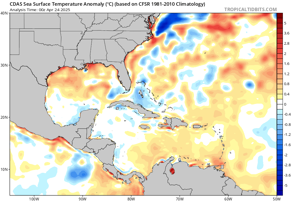
869MB wrote:Looking ahead to the Spring Thread, if higher than normal rainfall accumulations can materialize across most of the state of Texas through most of February, I’m beginning to speculate if the dry-line will tend to not mix as far eastward towards Louisiana or Arkansas due to the anomalously moist soils across our region. This in conjunction with the anomalous warmer waters in the central & west Gulf of Mexico right now, I’m starting to wonder if OK & TX may experience one or two widespread significant severe weather outbreaks during the Spring, of course assuming if jet dynamics and surface thermodynamics coincide accordingly, along with favorable teleconnections that will encourage such dynamics in the first place. Just something that’s been on my mind for the past week or so.
https://www.tropicaltidbits.com/analysis/ocean/cdas-sflux_ssta_watl_1.png
The cold shelf waters will mitigate any early season severe in the coastal plain (ie, Houston area), it will cause low clouds that won't want to break, meaning the cap won't brake. OTOH, the cap in winter is usually less strong and doesn't need much sun to break.
https://x.com/ReedTimmerUSA/status/1883216224479293450
2 likes

-
Stratton23
- Category 5
- Posts: 3485
- Joined: Fri Jul 21, 2023 10:59 pm
- Location: Katy, Tx
Re: Texas Winter 2024-2025
you can see that icy battlezone taking place in central texas on the 18z GFS, cold arctic dense air clashing with warm vulf mositure surging over the top and se ridge fighting, almost an ice storm on this run
2 likes
Who is online
Users browsing this forum: steviegcomeback, tolakram and 49 guests