#7489 Postby dhweather » Thu Feb 06, 2014 12:07 pm
From: National Weather Service, Fort Worth
Date: Thursday, 6 February 2014 9:44 CST
Good morning everyone,
Here's our latest thinking concerning the ongoing snow event:
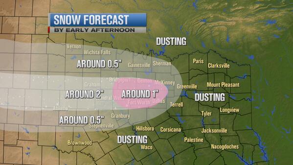
A broad area of light snow will continue north of a Goldthwaite to Waco to Athens line. In general, additional amounts of less than 1/4" are expected.
However, within this large area, there will be a couple of bands that will set up across north Texas through Noon. We think one band will set up from Palo Pinto County, east through Parker, Tarrant, Denton and Collin Counties. Dallas and Rockwall Counties will be on the south fringe of this, but some of the areas north of I-20 could also be affected. Within these "enhanced areas", an additional 1/2" to 1" can be expected.
Another enhanced band may set up from Hamilton County, east through Bosque, Hill and Bosque Counties. Here, we can expect an additional 1/4 to 1/2".
Temperatures will remain in the upper teens to lower 20s through midday.
We think the snow will begin to taper off from west to east starting around 11 am. Along the I-35 corridor, the snow should end in the 1-2 pm timeframe, with eastern counties ending in the 2-4 pm period.
We'll continue to update as quickly as we can. Please call if you have additional questions.
Thanks,
Tom
Date: Thursday, 6 February 2014 10:11 CST
Quick NWS thoughts on road conditions
Folks, I sent the following to a few jurisdictions concerning our thoughts on street conditions, based on the weather. I thought I'd share it out to everyone if it helps.
The great majority of the snow should be over by 2 pm or earlier. Additional accumulations should be 1/4" or less. However, the snow is obviously getting packed into ice - particularly at intersections and on some streets where the traffic is greater. It's unlikely that the street conditions will get worse than they are now. However, even with the snow ending this afternoon, there will likely still be some icy conditions persisting on the streets through this afternoon, and likely overnight as well. Temps will remain well below freezing, so the only way we're going to lose the snow (and ice) is through evaporation/sublimation during the next 12-18 hours. I assume continued traffic will wear it down a bit as well. Just our thoughts at this time. Hope this helps!
Tom
0 likes
The above post and any post by dhweather is NOT an official forecast and should not be used as such. It is just the opinion of the poster and may or may not be backed by sound meteorological data. It is NOT endorsed by any professional institution including storm2k.org. For official information, please refer to NWS products.
 The posts in this forum are NOT official forecast and should not be used as such. They are just the opinion of the poster and may or may not be backed by sound meteorological data. They are NOT endorsed by any professional institution or