Texas winter wx thread (2009-2010)
Moderator: S2k Moderators
Forum rules
 The posts in this forum are NOT official forecast and should not be used as such. They are just the opinion of the poster and may or may not be backed by sound meteorological data. They are NOT endorsed by any professional institution or STORM2K.

The posts in this forum are NOT official forecast and should not be used as such. They are just the opinion of the poster and may or may not be backed by sound meteorological data. They are NOT endorsed by any professional institution or STORM2K.
-
Extremeweatherguy

- Category 5

- Posts: 11095
- Joined: Mon Oct 10, 2005 8:13 pm
- Location: Florida
-
southerngale

- Retired Staff

- Posts: 27418
- Joined: Thu Oct 10, 2002 1:27 am
- Location: Southeast Texas (Beaumont area)
0 likes
Please support Storm2k by making a donation today. It is greatly appreciated! Click here: 
 my Cowboys my Rockets my Astros
my Cowboys my Rockets my Astros
Re: Texas winter wx thread (2009-2010)
This would be the second time I'm too north for snow. How often does that happen?  I hope you get some snow southerngale!
P.S. Page 400!!
P.S. Page 400!!
0 likes

Re: Texas winter wx thread (2009-2010)
Turtle wrote:This would be the second time I'm too north for snow. How often does that happen?
P.S. Page 400!!
I have a feeling north texas, through north east texas will see something. Maybe just a dusting or an inch. But I think there will be a tad more moisture up here than the 18z is showing. I do think central Texas will get bulk of it, though.
0 likes

The ensembles mostly has some snow for north Texas and what falls should stick nicely with cold northerly winds, but it does appear Waco to Austin is where the GFS likes hitting this time  . They are well deserving of it though.
0 likes
The above post and any post by Ntxw is NOT an official forecast and should not be used as such. It is just the opinion of the poster and may or may not be backed by sound meteorological data. It is NOT endorsed by any professional institution including Storm2k. For official information, please refer to NWS products.
Help support Storm2K!

A couple of things that need to stay in our heads.
One is that Well frankly it was to 18z runs. lets see what the 0z run shows.
Two is that it really hard for me to believe that 0 precip is possible in dfw since this time yesterday it was showing .70 for my area.
Three is that this is textbook wobbling by the models. This has happened before. look for the runs to start going back to the north within the next few runs. maybee by the 00z runs.
0 likes
Re:
Ntxw wrote:The ensembles mostly has some snow for north Texas and what falls should stick nicely with cold northerly winds, but it does appear Waco to Austin is where the GFS likes hitting this time
Yes I just hope by some small miracle San Antonio sees something too.
0 likes
Re:
gofrogs2 wrote:A couple of things that need to stay in our heads.
One is that Well frankly it was to 18z runs. lets see what the 0z run shows.
Two is that it really hard for me to believe that 0 precip is possible in dfw since this time yesterday it was showing .70 for my area.
Three is that this is textbook wobbling by the models. This has happened before. look for the runs to start going back to the north within the next few runs. maybee by the 00z runs.
Like I said I don't believe the 18z. I think we'll see something up here. I think it's just trending right now that central texas will get more than us. Of course it could just be wobbling, but if still shows the same on the 0z runs, and the 12z run tomorrow than I think it's more than a wobble.
0 likes
The storm is still well offshore and hasn't even organized itself yet, don't write it off. As for Portastorm, get you're kicking shoes ready!
0 likes
The above post and any post by Ntxw is NOT an official forecast and should not be used as such. It is just the opinion of the poster and may or may not be backed by sound meteorological data. It is NOT endorsed by any professional institution including Storm2k. For official information, please refer to NWS products.
Help support Storm2K!
Help support Storm2K!
-
southerngale
- Retired Staff
- Posts: 27418
- Joined: Thu Oct 10, 2002 1:27 am
- Location: Southeast Texas (Beaumont area)
Thanks, Turtle. I hope all of you up there get some too! Let's get all of Texas in on it. 
Earl's page hasn't updated with the 18z info, but here's the 12z for SE TX. It's a good bit further south than it was yesterday afternoon. And I'm in the pink!

Earl's page hasn't updated with the 18z info, but here's the 12z for SE TX. It's a good bit further south than it was yesterday afternoon. And I'm in the pink!
0 likes
Please support Storm2k by making a donation today. It is greatly appreciated! Click here:
my Cowboys my Rockets my Astros
my Cowboys my Rockets my Astros-
Portastorm

- Storm2k Moderator

- Posts: 9954
- Age: 63
- Joined: Fri Jul 11, 2003 9:16 am
- Location: Round Rock, TX
- Contact:
Re:
Ntxw wrote:The storm is still well offshore and hasn't even organized itself yet, don't write it off. As for Portastorm, get you're kicking shoes ready!
I couldn't agree more Ntxw ... until this storm is close to the coast and has been sampled by the upper air network I wouldn't (and I'm not) getting too hung up on any model run. I still think anyone from the Red River to San Antonio has a shot at accumulating snow.
As for my kicking shoes ... let's just say that I will be addressing that subject tomorrow after the 12z runs. I do know where they are in the closet though!
0 likes
As for now, I'll be awaiting patiently for Portastorm's press conference tomorrow via 12z.
0 likes
The above post and any post by Ntxw is NOT an official forecast and should not be used as such. It is just the opinion of the poster and may or may not be backed by sound meteorological data. It is NOT endorsed by any professional institution including Storm2k. For official information, please refer to NWS products.
Help support Storm2K!
Help support Storm2K!
-
southerngale
- Retired Staff
- Posts: 27418
- Joined: Thu Oct 10, 2002 1:27 am
- Location: Southeast Texas (Beaumont area)
Re:
Ntxw wrote::uarrow: Earl's page only makes graphics for 0z and 12z, and for sure! I hope you guys see more than just a dusting to an inch
As for now, I'll be awaiting patiently for Portastorm's press conference tomorrow via 12z.
Oh, ok. Thanks. I'm an Earl newbie.
0 likes
Please support Storm2k by making a donation today. It is greatly appreciated! Click here:
my Cowboys my Rockets my Astros
my Cowboys my Rockets my Astros-
vbhoutex

- Storm2k Executive

- Posts: 29143
- Age: 74
- Joined: Wed Oct 09, 2002 11:31 pm
- Location: Cypress, TX
- Contact:
Re: Re:
Portastorm wrote:Ntxw wrote:The storm is still well offshore and hasn't even organized itself yet, don't write it off. As for Portastorm, get you're kicking shoes ready!
I couldn't agree more Ntxw ... until this storm is close to the coast and has been sampled by the upper air network I wouldn't (and I'm not) getting too hung up on any model run. I still think anyone from the Red River to San Antonio has a shot at accumulating snow.
As for my kicking shoes ... let's just say that I will be addressing that subject tomorrow after the 12z runs. I do know where they are in the closet though!
I'm amazed you could even find them. They've been sitting in the back of that closet for a long time!!
0 likes
Skywarn, C.E.R.T.
Please click below to donate to STORM2K to help with the expenses of keeping the site going:
Please click below to donate to STORM2K to help with the expenses of keeping the site going:
-
vbhoutex
- Storm2k Executive
- Posts: 29143
- Age: 74
- Joined: Wed Oct 09, 2002 11:31 pm
- Location: Cypress, TX
- Contact:
Re: Texas winter wx thread (2009-2010)
I have been watching this developing storm with interest. I have something I would like any of our resident pro-mets(and any others too)to comment on. for the last few days and it looks like tomorrow possibly too here in Houston we have not made our progged temps for highs. It appears we will be running 3-5 degrees below progs for highs. If this continues will this affect the possibilities of snow with us entering into the colder weather at a lower temperature than originally thought(if the Southern track trend continues)? Is anything like this figured into the models?
SG I am in the pink too! It looks like it goes right up my street on the West side of Houston.
SG I am in the pink too! It looks like it goes right up my street on the West side of Houston.
0 likes
Skywarn, C.E.R.T.
Please click below to donate to STORM2K to help with the expenses of keeping the site going:
Please click below to donate to STORM2K to help with the expenses of keeping the site going:
-
Nederlander
- S2K Supporter

- Posts: 1259
- Joined: Sat Jul 19, 2008 4:28 pm
- Location: Conroe, TX
Re: Texas winter wx thread (2009-2010)
Cautiously keeping my fingers crossed that the southward trend continues.. Trying not to get too excited yet.. Looking forward to the 0z run
0 likes
Re: Texas winter wx thread (2009-2010)
Larry Cosgrove's thoughts, he mentions the Tues storm. He's been pretty solid this winter.
http://www.examiner.com/x-3775-Houston-Weather-Examiner
http://www.examiner.com/x-3775-Houston-Weather-Examiner
0 likes
The above post and any post by Ntxw is NOT an official forecast and should not be used as such. It is just the opinion of the poster and may or may not be backed by sound meteorological data. It is NOT endorsed by any professional institution including Storm2k. For official information, please refer to NWS products.
Help support Storm2K!
Help support Storm2K!
-
Extremeweatherguy
- Category 5
- Posts: 11095
- Joined: Mon Oct 10, 2005 8:13 pm
- Location: Florida
Re:
gofrogs2 wrote:Hey guys what are the new model runs showing.
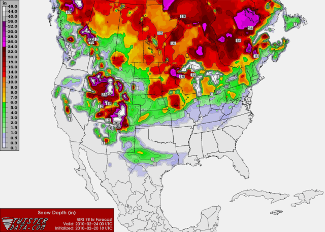
00z NAM snow depth maps..
HOUR 60
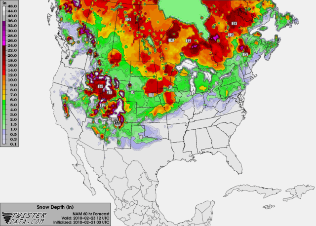
HOUR 66
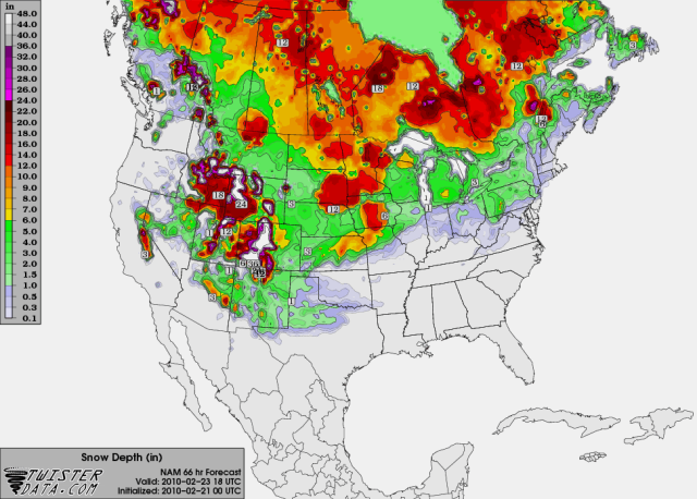
HOUR 72
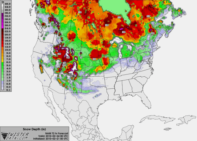
HOUR 78

Last edited by Extremeweatherguy on Sat Feb 20, 2010 10:03 pm, edited 1 time in total.
0 likes
500mb flow energy from the NAM has the energy crossing more southwest to NE unless im seeing wrong, but the storm just doesn't have a lot of moisture to put into the cold sector.
0 likes
The above post and any post by Ntxw is NOT an official forecast and should not be used as such. It is just the opinion of the poster and may or may not be backed by sound meteorological data. It is NOT endorsed by any professional institution including Storm2k. For official information, please refer to NWS products.
Help support Storm2K!
Help support Storm2K!
Who is online
Users browsing this forum: Google Adsense [Bot] and 57 guests