Frick & Frack's Snowfall Thread
Moderator: S2k Moderators
Forum rules
 The posts in this forum are NOT official forecast and should not be used as such. They are just the opinion of the poster and may or may not be backed by sound meteorological data. They are NOT endorsed by any professional institution or STORM2K.

The posts in this forum are NOT official forecast and should not be used as such. They are just the opinion of the poster and may or may not be backed by sound meteorological data. They are NOT endorsed by any professional institution or STORM2K.

-
PTrackerLA

- Category 5

- Posts: 5281
- Age: 42
- Joined: Thu Oct 10, 2002 8:40 pm
- Location: Lafayette, LA
Re: Frick & Frack's Snowfall Thread
Awesome sight this morning, glad I got to enjoy seeing the snow come down hard before dawn. It was surreal driving to work with a big pile of snow on the hood and everything coated in white. This easily beats any of the winter weather events from this decade. Now why can't we get these upper level lows to scoot over us like this every year? I'm sure most wouldn't mind!
0 likes
-
southerngale

- Retired Staff

- Posts: 27418
- Joined: Thu Oct 10, 2002 1:27 am
- Location: Southeast Texas (Beaumont area)
Re:
CajunMama wrote:This thread FINALLY worked!
Is this one of the earliest dates we've had snow in lafayette?
It did! YAY! So exciting for us down here in the deep south!

Going to post the links to our snow pic threads to keep in this thread as well.
Frick's snow pic thread
Frack's snow pic thread
0 likes
-
Dave

- Retired Staff
- Posts: 13442
- Age: 75
- Joined: Tue Aug 01, 2006 3:57 pm
- Location: Milan Indiana
- Contact:
If it wasn't for Miss Mary up here my area who wants snow for us I'd be more than happy to send all of the snow we usually get each year down to you...but...guess I'll have to keep this next batch for her.
Winter hasn't started yet officially so the best advice I can give to you'all down south, "you just gotta believe and it may happen again this winter".

Winter hasn't started yet officially so the best advice I can give to you'all down south, "you just gotta believe and it may happen again this winter".
0 likes

-
southerngale
- Retired Staff
- Posts: 27418
- Joined: Thu Oct 10, 2002 1:27 am
- Location: Southeast Texas (Beaumont area)
Btw, this event crushed 1989, at least in my area. Not sure about Frick's. We didn't have near this much snow in 1989.
PUBLIC INFORMATION STATEMENT
NATIONAL WEATHER SERVICE LAKE CHARLES LA
1015 AM CST THU DEC 11 2008
...RECORD EARLY DECEMBER SNOWFALL ACROSS THE AREA...
A COLD UPPER LEVEL LOW PRESSURE SYSTEM MOVING ACROSS SOUTHEAST
TEXAS AND SOUTHWEST LOUISIANA HAS PRODUCED WIDESPREAD LIGHT TO
MODERATE SNOW. THIS RARE SNOW EVENT IS THE EARLIEST MEASURABLE
SNOWFALL OF THE FALL/WINTER SEASON IN RECORDED HISTORY AT
BEAUMONT PORT ARTHUR AND LAKE CHARLES. IN ADDITION...ALL TIME
RECORD SNOWFALL AMOUNTS FOR THE MONTH OF DECEMBER HAVE BEEN SET
AT BOTH BEAUMONT PORT ARTHUR AND LAKE CHARLES. SNOW CONTINUES TO
FALL THIS MORNING AND THESE SNOW TOTALS WILL BE REVISED AND
UPDATED LATER TODAY.
SNOW TOTALS AS OF 1015 AM CDT:
TEXAS
-----
LUMBERTON 4.0 INCH
WEST BEAUMONT 4.0 INCH
WOODVILLE 3.0 INCH
BEAUMONT CITY 2.5 INCH
WILDWOOD 2.2 INCH
GROVES 2.0 INCH
SILSBEE 2.0 INCH
SE TX REGIONAL ARPT 1.8 INCH
NEDERLAND 1.0 INCH
ORANGE 1.0 INCH
PORT NECHES 1.0 INCH
JASPER 0.5 INCH
LOUISIANA
---------
OPELOUSAS 6.0 INCH
WASHINGTON 6.0 INCH
EUNICE 3.0 INCH
OAKDALE 3.0 INCH
OPELOUSAS 3.0 INCH
CHURCH POINT 2.5 INCH
FOREST HILL 2.0 INCH
DE QUINCY 1.5 INCH
VINTON 1.5 INCH
BUNKIE 1.3 INCH
ELMER 1.2 INCH
MOSS BLUFF 1.2 INCH
BELL CITY 1.0 INCH
DERIDDER 1.0 INCH
JENNINGS 1.0 INCH
LAKE ARTHUR 1.0 INCH
SAM HOUSTON JONES SP 1.0 INCH
WOODWORTH 1.0 INCH
SULPHUR 1.0 INCH
LAFAYETTE 1.0 INCH
LAKE CHARLES SALT WB 0.4 INCH
NWS LAKE CHARLES 0.4 INCH
LEESVILLE 0.2 INCH
ALEXANDRIA 911 TRACE
$$
SHAMBURGER
---------------------------------
RECORD EVENT REPORT
NATIONAL WEATHER SERVICE LAKE CHARLES, LA
840 AM CST THU NOV 13 2008
...RECORD EARLIEST MEASURABLE SNOWFALL SET AT BEAUMONT PORT ARTHUR...
...ALL TIME RECORD SNOWFALL FOR DECEMBER SET AT BEAUMONT PORT
ARTHUR...
OFFICIALLY 1.8 INCHES OF SNOW WAS MEASURED AT THE SOUTHEAST TEXAS
REGIONAL AIRPORT. THIS SETS THE ALL TIME EARLIEST MEASURABLE
SNOWFALL RECORD FOR BEAUMONT PORT ARTHUR. THE PREVIOUS RECORD WAS
SET ON DECEMBER 22 1989 WHEN 0.7 INCHES OF SNOW WAS MEASURED.
$$
SHAMBURGER
0 likes
-
southerngale
- Retired Staff
- Posts: 27418
- Joined: Thu Oct 10, 2002 1:27 am
- Location: Southeast Texas (Beaumont area)
Re: Re:
ai9d wrote:southerngale wrote:Thanks - this is SO COOL!
I see the northern express snow train did arrive almost on time! See you just gotta believe!
You were right and thanks for sending it this way! You did say you'd keep it on standby for me, didn't you?

0 likes

Re: Frick & Frack's Snowfall Thread
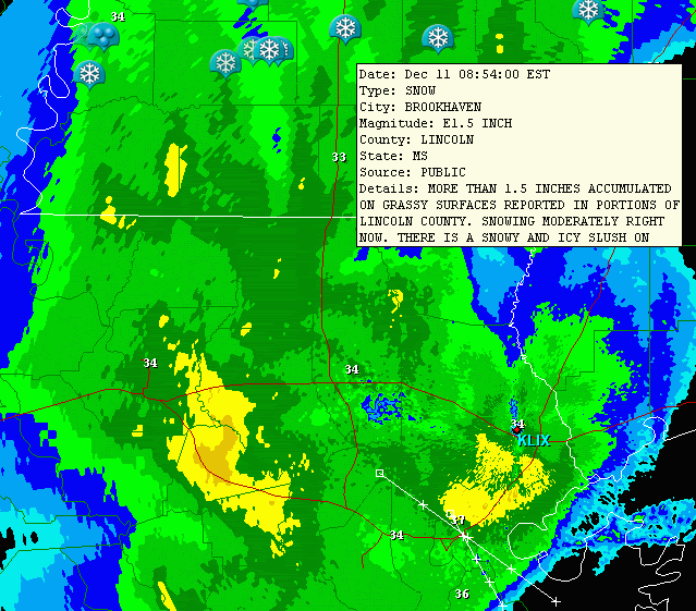
8 inches of snow in Amite, LA - at least that's what was reported on tv.
0 likes
-
Ed Mahmoud
Re: Frick & Frack's Snowfall Thread
This is my first winter of wonderful-casting winter precip for HOU, and look how well it worked out!
So well, it made it all the way to Mississippi.
So well, it made it all the way to Mississippi.
0 likes
-
southerngale
- Retired Staff
- Posts: 27418
- Joined: Thu Oct 10, 2002 1:27 am
- Location: Southeast Texas (Beaumont area)


-
srainhoutx

- S2K Supporter

- Posts: 6919
- Age: 68
- Joined: Sun Jan 14, 2007 11:34 am
- Location: Haywood County, NC
- Contact:
Re: Frick & Frack's Snowfall Thread
Ya know it's Winter TX/LA. 
 I'm liking the chances of lots of pics in this thread as time goes by. Maybe everyone will get their chance in this El Nino Pattern.
0 likes
Carla/Alicia/Jerry(In The Eye)/Michelle/Charley/Ivan/Dennis/Katrina/Rita/Wilma/Ike/Harvey
Member: National Weather Association
Wx Infinity Forums
http://wxinfinity.com/index.php
Facebook.com/WeatherInfinity
Twitter @WeatherInfinity
Member: National Weather Association
Wx Infinity Forums
http://wxinfinity.com/index.php
Facebook.com/WeatherInfinity
Twitter @WeatherInfinity
-
CajunMama
- Retired Staff
- Posts: 10791
- Joined: Thu Feb 06, 2003 9:57 pm
- Location: 30.22N, 92.05W Lafayette, LA
Re: Frick & Frack's Snowfall Thread
From the Lake Charles NWS
From the Beaumont NWS

Friday: A 50 percent chance of rain, mainly after noon. Mostly cloudy, with a high near 47. North wind between 10 and 15 mph.
Friday Night: A chance of rain and snow before midnight, then a chance of snow. Mostly cloudy, with a low around 33. North wind around 10 mph. Chance of precipitation is 50%.
From the Beaumont NWS
Friday: A chance of rain before noon, then a chance of rain and snow. Cloudy, with a high near 46. North wind between 10 and 15 mph, with gusts as high as 20 mph. Chance of precipitation is 50%.
Friday Night: A chance of rain and snow before midnight, then a slight chance of snow. Mostly cloudy, with a low around 32. North wind between 10 and 15 mph, with gusts as high as 20 mph. Chance of precipitation is 50%.
0 likes
Who is online
Users browsing this forum: No registered users and 105 guests