Winter 2010-11 for the Southern Plains
Moderator: S2k Moderators
Forum rules
 The posts in this forum are NOT official forecast and should not be used as such. They are just the opinion of the poster and may or may not be backed by sound meteorological data. They are NOT endorsed by any professional institution or STORM2K.

The posts in this forum are NOT official forecast and should not be used as such. They are just the opinion of the poster and may or may not be backed by sound meteorological data. They are NOT endorsed by any professional institution or STORM2K.

Re: Winter 2010-11 for the Southern Plains
I’m a school administrator in southwest Oklahoma. I was wondering about next week’s winter storm and the possible effects on this area.
0 likes
-
Extremeweatherguy

- Category 5

- Posts: 11095
- Joined: Mon Oct 10, 2005 8:13 pm
- Location: Florida
Re: Winter 2010-11 for the Southern Plains
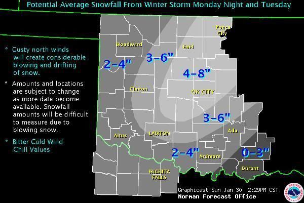
A nice starting point for the NWS, IMO. Midway between the spread in the models, but more weight given towards the possibility of higher amounts.
0 likes
-
Extremeweatherguy
- Category 5
- Posts: 11095
- Joined: Mon Oct 10, 2005 8:13 pm
- Location: Florida
Crazy discussion from Norman this afternoon...
AREA FORECAST DISCUSSION
NATIONAL WEATHER SERVICE NORMAN OK
232 PM CST SUN JAN 30 2011
.DISCUSSION...
POTENTIALLY CRIPPLING COMBINATION OF WIND... COLD AND WINTER PRECIP NOW
APPEARS IMMINENT FOR MUCH OF THE AREA MONDAY NIGHT INTO TUESDAY. WE
WILL BE ISSUING A PDS VERSION OF THE WSW BY 3 PM WHICH WILL EXPAND
THE WINTER STORM WATCH INTO THE REST OF WCENTRAL/SW OK AND OUR TX
ZONES... UPGRADE CENTRAL AND NCENTRAL OK TO A WINTER STORM WARNING
WHERE CONFIDENCE IS HIGHEST IN THE POTENTIAL FOR MAJOR IMPACTS...
AND ADD A WIND CHILL WATCH FOR NW OK WHERE COMPUTED WIND CHILLS ARE
-15 OR LESS DURING MUCH OF THE PERIOD FROM LATE MON NIGHT INTO WED
MORNING. PARTS OF THE AREA EVENTUALLY COULD NEED AN UPGRADE TO
BLIZZARD WARNING BY TUESDAY MORNING.
CONDITIONS LOOK OKAY FOR THE MOST PART BETWEEN NOW AND LATE
MONDAY... ALTHOUGH PARTS OF N AND CENTRAL OK MAY HAVE TO DEAL WITH A
LITTLE FREEZING DRIZZLE LATER TONIGHT INTO MONDAY. WE WILL HANDLE
THAT WITH AN ADVISORY IF NEEDED. OTHERWISE THE EMPHASIS AT THIS TIME
IS ON GETTING EVERYONE TO TAKE PROPER STEPS NOW BY OBTAINING
NECESSARY PROVISIONS... AND NOT PLANNING ON GOING ANYWHERE FROM LATE
MONDAY NIGHT INTO TUESDAY UNLESS ABSOLUTELY NECESSARY.
ALL INDICATIONS ARE THAT CONDITIONS WILL DETERIORATE RAPIDLY AT SOME
POINT MONDAY NIGHT AS N-NE WINDS INCREASE AND COLD AIR GETS COLDER
AND DEEPER. PRECIP IS FORECAST TO INCREASE IN COVERAGE AND INTENSITY
00-06Z AND ESPECIALLY 06-12Z MONDAY NIGHT. TRANSITION FROM LIQUID TO
FREEZING TO FROZEN SHOULD BE FAIRLY RAPID GIVEN THE STRONG LOW-LEVEL
COLD ADVECTION... ALTHOUGH SLEET MAY PERSIST INTO TUE MORNING SE
PARTS OF AREA. LIMITED ICE ACCRETION WILL BE OFFSET BY STRONG
WINDS... WHICH MAY BRING DOWN EVEN LIGHTLY-COATED TREES AND POWER
LINES. FOCUS WILL BE LESS ON SNOW/ICE AMOUNTS AND MORE ON THE
POTENTIAL FOR PARALYZING WINTER STORM CONDITIONS DUE TO SNOW AND
BLOWING/DRIFTING ALONG WITH LIFE-THREATENING WIND CHILLS. THAT BEING
SAID... WE CURRENTLY PAINT A BROAD BAND OF 4-8 INCHES CENTERED
ROUGHLY LAWTON-OKC-STILLWATER WITH 2-5 OVER MUCH OF THE REST OF THE
WATCH AREA. GIVEN THE LIKELIHOOD OF SEVERE BLOWING/DRIFTING... WE
MAY NEVER REALLY KNOW. OBVIOUS ANALOG WOULD BE XMAS EVE 2009... AND
FOR SOME AREAS THIS MAY BE AS BAD OR WORSE THAN THAT ONE.
SNOW TAPERS OFF LATE TUE BUT WIND AND BLOWING/DRIFTING TO CONTINUE
AS TEMPS AND WIND CHILLS DROP FURTHER. WIND CHILL ADVISORIES
CERTAINLY WILL BE NEEDED ON THE BACK SIDE OF THIS EVENT... OR WIND
CHILL WARNINGS EXPANDED. THIS MAY BE THE COLDEST THAT MANY AREAS
HAVE EXPERIENCED IN YEARS.
STANDARD INITIALIZATION ROUTINE INVOKED FOR THE REST OF THE
FORECAST. MAY HAVE TO ADD SOME LOW POPS EVENTUALLY FOR ANOTHER
EVENT TOWARD THE END OF THE WORK WEEK BUT FOCUS IS SQUARELY ON THE
EARLY-WEEK EVENT.
0 likes
-
BlueIce
- S2K Supporter

- Posts: 194
- Age: 37
- Joined: Mon Sep 01, 2008 10:05 pm
- Location: Oklahoma City, Oklahoma
Re: Winter 2010-11 for the Southern Plains
kmc8264 wrote:I’m a school administrator in southwest Oklahoma. I was wondering about next week’s winter storm and the possible effects on this area.
Based on current model trends SW OK should receive a decent amount of winter precipitation. I would be prepared for travel problems on Tuesday due to blowing and possibly drifting snow. I would monitor http://www.srh.noaa.gov/oun/ for the latest winter weather advisory updates.
On that note check out the 18z NAM. 18+ inches for OKC!!


0 likes
-
SouthernMet

- Category 3

- Posts: 857
- Joined: Sun Aug 29, 2010 8:23 pm
- Location: fort worth, tx
Re: Winter 2010-11 for the Southern Plains
URGENT - WINTER WEATHER MESSAGE
NATIONAL WEATHER SERVICE NORMAN OK
308 PM CST SUN JAN 30 2011
OKZ007-008-012-013-018>020-023>031-040-310515-
/O.UPG.KOUN.WS.A.0001.110201T0000Z-110202T0000Z/
/O.NEW.KOUN.WS.W.0001.110201T0000Z-110202T0000Z/
GRANT-KAY-GARFIELD-NOBLE-KINGFISHER-LOGAN-PAYNE-CADDO-CANADIAN-
OKLAHOMA-LINCOLN-GRADY-MCCLAIN-CLEVELAND-POTTAWATOMIE-SEMINOLE-
GARVIN-
INCLUDING THE CITIES OF...MEDFORD...PONCA CITY...ENID...PERRY...
KINGFISHER...GUTHRIE...STILLWATER...ANADARKO...YUKON...EL RENO...
MUSTANG...OKLAHOMA CITY...CHANDLER...CHICKASHA...PURCELL...
NORMAN...MOORE...SHAWNEE...SEMINOLE...PAULS VALLEY
308 PM CST SUN JAN 30 2011
...WINTER STORM WARNING IN EFFECT FROM 6 PM MONDAY TO 6 PM CST
TUESDAY...
THE NATIONAL WEATHER SERVICE IN NORMAN HAS ISSUED A WINTER STORM
WARNING FOR HEAVY SNOW AND BLOWING AND DRIFTING SNOW... WHICH IS
IN EFFECT FROM 6 PM MONDAY TO 6 PM CST TUESDAY FOR MUCH OF CENTRAL
AND NORTH CENTRAL OKLAHOMA. THE WINTER STORM WATCH IS NO LONGER IN
EFFECT.
THIS IS A PARTICULARLY DANGEROUS WINTER STORM SITUATION... WITH THE
POTENTIAL FOR BLIZZARD OR NEAR-BLIZZARD CONDITIONS ALONG WITH
LIFE-THREATENING WIND CHILLS. TRAVEL IS LIKELY TO BECOME EXTREMELY
DIFFICULT IF NOT IMPOSSIBLE BY TUESDAY MORNING. ALL RESIDENTS IN
CENTRAL AND NORTHERN OKLAHOMA ARE URGED TO TAKE THIS DEVELOPING
WINTER STORM SERIOUSLY AND PLAN FOR THE POSSIBILITY OF
SIGNIFICANT DISRUPTIONS BY LATE MONDAY NIGHT AND TUESDAY MORNING.
* A STRONG STORM SYSTEM WILL MOVE FROM SOUTHERN NEVADA INTO THE
FOUR CORNERS REGION BY MIDDAY MONDAY. THIS SYSTEM WILL THEN MOVE
ACROSS THE SOUTHERN PLAINS ON TUESDAY.
* TIMING: RAIN WILL CHANGE QUICKLY TO A MIX OF FREEZING RAIN SLEET
AND SNOW MONDAY EVENING. SNOW MAY BECOME HEAVY AT TIME LATE
MONDAY NIGHT INTO TUESDAY MORNING... ALONG WITH SUBSTANTIAL
BLOWING AND DRIFTING... BEFORE TAPERING OFF TUESDAY AFTERNOON.
* MAIN IMPACT: A CRIPPLING COMBINATION OF SNOW AND BLOWING SNOW
FROM LATE MONDAY NIGHT THROUGH TUESDAY MORNING... MAKING TRAVEL
VERY DIFFICULT OR IMPOSSIBLE.
* OTHER IMPACTS: VERY STRONG NORTH WINDS WILL CREATE DANGEROUS
WIND CHILL VALUES LATE MONDAY NIGHT INTO TUESDAY. THE STRONG
WINDS... ALONG WITH EVEN LIGHT ACCUMULATIONS OF ICE OR SNOW ON
EXPOSED SURFACES... ALSO MAY LEAD TO DISRUPTIONS OF COMMERCIAL
POWER. BLOWING SNOW MAY CREATE POOR VISIBILITY AND NEAR-WHITEOUT
CONDITIONS IN SOME AREAS.
* ROADS...BRIDGES...AND OVERPASSES WILL BECOME SLICK AND HAZARDOUS
AS EARLY AS TUESDAY EVENING... MAKING TRAVEL TREACHEROUS. VERY
COLD CONDITIONS FOLLOWING THE STORM MAY KEEP SOME ROADS FROZEN
AND HAZARDOUS FOR SEVERAL DAYS.
PRECAUTIONARY/PREPAREDNESS ACTIONS...
* PLAN NOW FOR THE POSSIBILITY OF IMMOBILIZING WEATHER CONDITIONS
BY TUESDAY MORNING. STOCK UP ON NECESSARY FOOD AND OTHER
PROVISIONS BEFORE THE STORM ARRIVES... INCLUDING ANY NECESSARY
MEDICATION.
* CONSIDER CHANGING TRAVEL PLANS. IT IS PROBABLY A GOOD IDEA TO
PLAN FOR THE POSSIBILITY THAT UNNECESSARY TRAVEL MAY BE
RESTRICTED... IF NOT IMPOSSIBLE... BY EARLY TUESDAY.
* STAY UP TO DATE ON THE LATEST WEATHER INFORMATION AS THIS
DANGEROUS EVENT CONTINUES TO UNFOLD. WEATHER INFORMATION CAN BE
FOUND ON THE NORMAN FORECAST OFFICE WEB SITE. ALSO STAY TUNED TO
NOAA WEATHER RADIO...COMMERCIAL RADIO OR TELEVISION FOR THE
LATEST INFORMATION CONCERNING THIS WEATHER EVENT.
0 likes
Nothing that SouthernMet posts, is an official forecast,nor does it reflect views of STORM2K.. SouthernMet is just adding to the great discussions on STORM2K.. Refer to NWS for official forecasts.
-
SouthernMet
- Category 3
- Posts: 857
- Joined: Sun Aug 29, 2010 8:23 pm
- Location: fort worth, tx
Re: Winter 2010-11 for the Southern Plains
URGENT - WINTER WEATHER MESSAGE
NATIONAL WEATHER SERVICE NORMAN OK
308 PM CST SUN JAN 30 2011
OKZ014-021-033-034-036-037-044-045-050-TXZ083>090-310515-
/O.EXA.KOUN.WS.A.0001.110201T0000Z-110202T0000Z/
ROGER MILLS-BECKHAM-HARMON-GREER-JACKSON-TILLMAN-COTTON-JEFFERSON-
LOVE-HARDEMAN-FOARD-WILBARGER-WICHITA-KNOX-BAYLOR-ARCHER-CLAY-
INCLUDING THE CITIES OF...CHEYENNE...ELK CITY...SAYRE...HOLLIS...
MANGUM...ALTUS...FREDERICK...WALTERS...WAURIKA...MARIETTA...
QUANAH...CHILLICOTHE...CROWELL...VERNON...WICHITA FALLS...
MUNDAY...KNOX CITY...SEYMOUR...ARCHER CITY...HOLLIDAY...
LAKESIDE CITY...HENRIETTA
308 PM CST SUN JAN 30 2011
...WINTER STORM WATCH IN EFFECT FROM MONDAY EVENING THROUGH
TUESDAY AFTERNOON...
THE NATIONAL WEATHER SERVICE IN NORMAN HAS EXPANDED THE WINTER
STORM WATCH... WHICH IS IN EFFECT FROM MONDAY EVENING THROUGH
TUESDAY AFTERNOON. THE WINTER STORM WATCH NOW INCLUDES MUCH OF
WEST CENTRAL AND SOUTHWESTERN OKLAHOMA AND ALL OF WESTERN NORTH
TEXAS.
* A STRONG STORM SYSTEM WILL MOVE FROM SOUTHERN NEVADA INTO THE
FOUR CORNERS REGION BY MIDDAY MONDAY. THIS SYSTEM WILL THEN MOVE
ACROSS THE SOUTHERN PLAINS ON TUESDAY.
* TIMING: SNOW...SLEET AND SOME FREEZING RAIN IS EXPECTED TO
DEVELOP BY MONDAY EVENING AND INCREASE IN INTENSITY DURING THE
OVERNIGHT HOURS. BY TUESDAY AFTERNOON MOST OF THE PRECIPITATION
IS EXPECTED TO BE VERY LIGHT.
* MAIN IMPACT: 3 TO 6 INCHES OR MORE OF SLEET AND SNOW ARE
POSSIBLE IN THE WATCH AREA... ALONG WITH LIGHT ACCUMULATIONS OF
GLAZE BEFORE THE PRECIPITATION CHANGES TO SNOW.
* OTHER IMPACTS: VERY STRONG NORTH WINDS WILL CREATE DANGEROUS
WIND CHILL VALUES MONDAY NIGHT INTO TUESDAY. THE STRONG WINDS
WILL ALSO CREATE SIGNIFICANT BLOWING AND DRIFTING OF SNOW AND
WILL CREATE POOR VISIBILITY.
* ROADS...BRIDGES...AND OVERPASSES WILL BECOME SLICK AND
HAZARDOUS...MAKING TRAVEL TREACHEROUS. VERY COLD TEMPERATURES
FOLLOWING THE STORM MAY MAKE SOME SECONDARY ROADS HAZARDOUS
FOR SEVERAL DAYS.
PRECAUTIONARY/PREPAREDNESS ACTIONS...
* PLAN NOW FOR THE POSSIBILITY OF HAZARDOUS TRAVEL CONDITIONS
DEVELOPING BY MONDAY NIGHT. TRAVEL MAY BECOME NEARLY IMPOSSIBLE
IN SOME AREAS BY TUESDAY MORNING. FROM NOW THROUGH MONDAY.. IT
WILL BE A GOOD IDEA TO STOCK UP ON FOOD AND OTHER PROVISIONS...
INCLUDING ANY NECESSARY MEDICAL SUPPLIES.
* CONSIDER CHANGING TRAVEL PLANS. TRAVEL IS LIKELY TO BE
DISCOURAGED BY TUESDAY... AND MAY BE RESTRICTED DUE TO THE
WEATHER.
* WEATHER INFORMATION CAN BE FOUND ON THE NORMAN FORECAST OFFICE
WEB SITE. ALSO STAY TUNED TO NOAA WEATHER RADIO...COMMERCIAL
RADIO OR TELEVISION FOR THE LATEST INFORMATION CONCERNING THIS
WEATHER EVENT
0 likes
Nothing that SouthernMet posts, is an official forecast,nor does it reflect views of STORM2K.. SouthernMet is just adding to the great discussions on STORM2K.. Refer to NWS for official forecasts.
-
Extremeweatherguy
- Category 5
- Posts: 11095
- Joined: Mon Oct 10, 2005 8:13 pm
- Location: Florida

-
BlueIce
- S2K Supporter
- Posts: 194
- Age: 37
- Joined: Mon Sep 01, 2008 10:05 pm
- Location: Oklahoma City, Oklahoma
Re:
Extremeweatherguy wrote:18z GFS is now more in line with the NAM and ECMWF. Not quite as crazy, but definitely getting closer...
Looks like somewhere between 8 and 12 inches for Oklahoma City if this run were correct.
The trend continues. The GFS was the first to show a large accumulation and then backed off and now it looks as if its coming back in line. I can't wait to live blog on this one.
0 likes
-
BlueIce
- S2K Supporter
- Posts: 194
- Age: 37
- Joined: Mon Sep 01, 2008 10:05 pm
- Location: Oklahoma City, Oklahoma
Re: Winter 2010-11 for the Southern Plains
Looks like the 00z NAM has moved the heaviest precip to the east some. With OKC still receiving 6" to 10" of snow.

0 likes
-
Extremeweatherguy
- Category 5
- Posts: 11095
- Joined: Mon Oct 10, 2005 8:13 pm
- Location: Florida
Yeah, the NAM moved the heaviest band *just* southeast, but not by much. The difference between 6-12 inches of snow and 12-18 inches of snow is only 10-20 miles, so it would be very close. In the end, it will probably all come down to watching things evolve in real time Monday night/Tuesday morning. Once we know where those heaviest bands are actually going to set up, we will have a much better idea of the accumulation distribution.
Either way though, even if this run played out exactly, 6-10 inches of snow in downtown OKC (8-12+ inches southeast side of town), would still be a major, major event; especially with the gusty winds in place.
Either way though, even if this run played out exactly, 6-10 inches of snow in downtown OKC (8-12+ inches southeast side of town), would still be a major, major event; especially with the gusty winds in place.
0 likes
-
TwisterFanatic

- Category 5
- Posts: 1041
- Joined: Mon Jun 28, 2010 12:43 pm
- Location: Sallisaw, Oklahoma
GFS has shifted well South East. Go figure. lol
0 likes
Personal Forecast Disclaimer:
The posts in this forum are NOT official forecast and should not be used as such. They are just the opinion of the poster and may or may not be backed by sound meteorological data. They are NOT endorsed by any professional institution or storm2k.org. For official information, please refer to the NHC and NWS products.
The posts in this forum are NOT official forecast and should not be used as such. They are just the opinion of the poster and may or may not be backed by sound meteorological data. They are NOT endorsed by any professional institution or storm2k.org. For official information, please refer to the NHC and NWS products.
-
Extremeweatherguy
- Category 5
- Posts: 11095
- Joined: Mon Oct 10, 2005 8:13 pm
- Location: Florida
Re:
Perhaps a slight shift, but nothing too significant IMO. The 6 inch line has actually expanded a little further south (both SW and SE) on this run, now reaching down to the Red River in the west, and the central Arkansas border in the east. For Oklahoma City in particular, this run looks pretty similar. May be a little less snow accumulation overall, but the same general "idea".TwisterFanatic wrote:GFS has shifted well South East. Go figure. lol
18z

00z

Last edited by Extremeweatherguy on Mon Jan 31, 2011 12:55 am, edited 2 times in total.
0 likes
-
Extremeweatherguy
- Category 5
- Posts: 11095
- Joined: Mon Oct 10, 2005 8:13 pm
- Location: Florida

-
wx247

- S2K Supporter
- Posts: 14279
- Age: 42
- Joined: Wed Feb 05, 2003 10:35 pm
- Location: Monett, Missouri
- Contact:
I like this run of the GFS. Let's keep it. I have never seen 20" of snow. haha
0 likes
Personal Forecast Disclaimer:
The posts in this forum are NOT official forecast and should not be used as such. They are just the opinion of the poster and may or may not be backed by sound meteorological data. They are NOT endorsed by any professional institution or storm2k.org. For official information, please refer to the NHC and NWS products.
The posts in this forum are NOT official forecast and should not be used as such. They are just the opinion of the poster and may or may not be backed by sound meteorological data. They are NOT endorsed by any professional institution or storm2k.org. For official information, please refer to the NHC and NWS products.
-
TwisterFanatic
- Category 5
- Posts: 1041
- Joined: Mon Jun 28, 2010 12:43 pm
- Location: Sallisaw, Oklahoma
Re: Winter 2010-11 for the Southern Plains
0z GFS, Oklahoma City
http://wxcaster.com/gis-gfs-snow-overla ... TIONID=TLX
0z GFS, Tulsa
http://wxcaster.com/gis-gfs-snow-overla ... TIONID=INX
0z GFS, Springfield
http://wxcaster.com/gis-gfs-snow-overla ... TIONID=SGF
Unreal forecasted totals..
Looks like we aren't gonna have any idea what is going to happen until it happens. NAM and GFS are totally different in placement of heaviest totals.
0 likes
Personal Forecast Disclaimer:
The posts in this forum are NOT official forecast and should not be used as such. They are just the opinion of the poster and may or may not be backed by sound meteorological data. They are NOT endorsed by any professional institution or storm2k.org. For official information, please refer to the NHC and NWS products.
The posts in this forum are NOT official forecast and should not be used as such. They are just the opinion of the poster and may or may not be backed by sound meteorological data. They are NOT endorsed by any professional institution or storm2k.org. For official information, please refer to the NHC and NWS products.
-
TwisterFanatic
- Category 5
- Posts: 1041
- Joined: Mon Jun 28, 2010 12:43 pm
- Location: Sallisaw, Oklahoma
Hmm, right now it looks as if the NAM is the outlier. The GFS, CMC and the UKMET have all shifted further south than previous. They're catching on with a stronger, digging storm, while the NAM is less amplified and with more northerly track.
0 likes
Personal Forecast Disclaimer:
The posts in this forum are NOT official forecast and should not be used as such. They are just the opinion of the poster and may or may not be backed by sound meteorological data. They are NOT endorsed by any professional institution or storm2k.org. For official information, please refer to the NHC and NWS products.
The posts in this forum are NOT official forecast and should not be used as such. They are just the opinion of the poster and may or may not be backed by sound meteorological data. They are NOT endorsed by any professional institution or storm2k.org. For official information, please refer to the NHC and NWS products.
-
Extremeweatherguy
- Category 5
- Posts: 11095
- Joined: Mon Oct 10, 2005 8:13 pm
- Location: Florida
00z ECMWF total storm QPF values...
Oklahoma City = 1.10"
Norman = 1.28"
Ponca City = 0.88"
Tulsa = 1.69"
Most all of this QPF falls as snow, with perhaps 0.05-0.15" of it falling as some kind of rainy/icy mix at the very beginning in some spots.
Using a plain 10:1 snow ratio and ignoring the possible mix at the beginning, these QPF values would equate to the following snow totals:
Oklahoma City = 11.0"
Norman = 12.8"
Ponca City = 8.8"
Tulsa = 16.9"
The actual snow ratios during this event will probably be higher higher than 10:1 though, perhaps as high as 20:1 by the afternoon. so an additional several inches might need to be added to the above totals.
0 likes
-
BlueIce
- S2K Supporter
- Posts: 194
- Age: 37
- Joined: Mon Sep 01, 2008 10:05 pm
- Location: Oklahoma City, Oklahoma
Re:
Extremeweatherguy wrote:00z ECMWF total storm QPF values...
Oklahoma City = 1.10"
Norman = 1.28"
Ponca City = 0.88"
Tulsa = 1.69"
Most all of this QPF falls as snow, with perhaps 0.05-0.15" of it falling as some kind of rainy/icy mix at the very beginning in some spots.
Using a plain 10:1 snow ratio and ignoring the possible mix at the beginning, these QPF values would equate to the following snow totals:
Oklahoma City = 11.0"
Norman = 12.8"
Ponca City = 8.8"
Tulsa = 16.9"
The actual snow ratios during this event will probably be higher higher than 10:1 though, perhaps as high as 20:1 by the afternoon. so an additional several inches might need to be added to the above totals.
I believe that the ECMWF has the highest QPF at the moment seems like the other models were in the 0.8 range.
I am fairly certain that I read a NWS forecast discussion that was saying the ratio looked like it would be closer to the 20:1 ratio. I'll see if I can find that FA discussion again.
0 likes
-
TwisterFanatic
- Category 5
- Posts: 1041
- Joined: Mon Jun 28, 2010 12:43 pm
- Location: Sallisaw, Oklahoma
Re: Winter 2010-11 for the Southern Plains
NAM starting to come in line with the other Major Models on the stronger, more southern track. You can see the difference between 0z and 6z.
0z..

6z..

Its not much, but its there.
0z..
6z..
Its not much, but its there.
0 likes
Personal Forecast Disclaimer:
The posts in this forum are NOT official forecast and should not be used as such. They are just the opinion of the poster and may or may not be backed by sound meteorological data. They are NOT endorsed by any professional institution or storm2k.org. For official information, please refer to the NHC and NWS products.
The posts in this forum are NOT official forecast and should not be used as such. They are just the opinion of the poster and may or may not be backed by sound meteorological data. They are NOT endorsed by any professional institution or storm2k.org. For official information, please refer to the NHC and NWS products.
Who is online
Users browsing this forum: No registered users and 290 guests