Texas Winter 2018-2019
Moderator: S2k Moderators
Forum rules
 The posts in this forum are NOT official forecast and should not be used as such. They are just the opinion of the poster and may or may not be backed by sound meteorological data. They are NOT endorsed by any professional institution or STORM2K.

The posts in this forum are NOT official forecast and should not be used as such. They are just the opinion of the poster and may or may not be backed by sound meteorological data. They are NOT endorsed by any professional institution or STORM2K.

-
Ralph's Weather
- S2K Supporter

- Posts: 3371
- Age: 38
- Joined: Fri Dec 13, 2013 11:55 am
- Location: Lindale, TX
- Contact:
Re: Texas Winter 2018-2019
I'd say choosy to half of euro ensemble members have snow within 100 miles of DFW. More than has have snow in Abilene. Only a couple for NE TX. Many in OK. On almost all it is a bullseye pattern vs a streak so only a small area gets hit hard. I'll take not being the target at this range. All other models are north of the Euro right now. The NAM is the weakest but this is really long range for the NAM.
0 likes
Follow on Facebook at Ralph's Weather.
-
Ralph's Weather
- S2K Supporter
- Posts: 3371
- Age: 38
- Joined: Fri Dec 13, 2013 11:55 am
- Location: Lindale, TX
- Contact:
Re: Texas Winter 2018-2019
Another 27 degree morning here.
0 likes
Follow on Facebook at Ralph's Weather.
-
AubreyStorm

- Category 1

- Posts: 337
- Age: 45
- Joined: Fri Jun 16, 2017 6:21 pm
- Location: Texas, USA
Re: Texas Winter 2018-2019
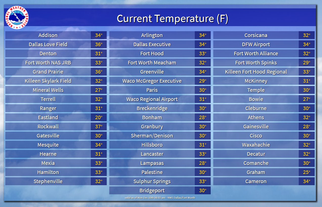
Via Twitter @NWS Forth Worth
1 likes
The posts are NOT an official forecast. Please REFER to the NHC and NWS for official forecasts and products.


Re: Texas Winter 2018-2019
DFW airport picked up the 9th freeze of the season this morning.
1 likes
The above post and any post by Ntxw is NOT an official forecast and should not be used as such. It is just the opinion of the poster and may or may not be backed by sound meteorological data. It is NOT endorsed by any professional institution including Storm2k. For official information, please refer to NWS products.
Help support Storm2K!
-
weatherdude1108
- Category 5

- Posts: 4228
- Joined: Tue Dec 13, 2011 1:04 pm
- Location: Northwest Austin/Cedar Park, TX
Re: Texas Winter 2018-2019
I took out some trash to the can at the street this morning, and there was a coating of ice on the trash can lid. It's sunny and clear as a bell outside. Just dew I'm assuming that became frost. It was around 35 where the temperature sensor was located, but obviously chillier at the surface.


I've noticed temperatures seem to be a bit colder this year, constant 30s rising to the 40s and 50s max more often than not, rather than rollercoastering from the 40s to the 70s/near 80 the past couple years, or a deep freeze to near 80 a couple days later.lol
We're actually having the consistent Fall/Winter temps that I remember experiencing as a kid, putting the coats on at high school football games, playing outside in coats blowing steam, etc. The fronts that move through seem to be packing more of a punch, and keep temps down longer, not rebounding much, which I am cool with. The snow pack up north I guess is helping with that, along with the 7 to 10 inches of snow around the Lubbock area.
  Keeps me in the holiday spirit!
I've noticed temperatures seem to be a bit colder this year, constant 30s rising to the 40s and 50s max more often than not, rather than rollercoastering from the 40s to the 70s/near 80 the past couple years, or a deep freeze to near 80 a couple days later.lol
We're actually having the consistent Fall/Winter temps that I remember experiencing as a kid, putting the coats on at high school football games, playing outside in coats blowing steam, etc. The fronts that move through seem to be packing more of a punch, and keep temps down longer, not rebounding much, which I am cool with.
2 likes
The preceding post is NOT an official forecast, and should not be used as such. It is only the opinion of the poster and may or may not be backed by sound meteorological data. It is NOT endorsed by any professional institution including storm2k.org. For Official Information please refer to the NHC and NWS products.
-
Yukon Cornelius
- S2K Supporter
- Posts: 1838
- Age: 42
- Joined: Thu Dec 20, 2012 9:23 pm
- Location: Dean, TX/Westcliffe, CO
Re: Texas Winter 2018-2019
Ralph's Weather wrote:Another 27 degree morning here.
Same here.
0 likes
#neversummer
-
wxman22

- Category 5
- Posts: 1849
- Joined: Mon Jan 30, 2006 12:39 am
- Location: Wichita Falls, TX
- Contact:
Re: Texas Winter 2018-2019
12z NAM shifted the system further to the south and now looks more like the Euro fwiw

0 likes
Re: Texas Winter 2018-2019
LaLa NAM does a lot of dynamic cooling southwest and south of the intense ULL. Surface is marginal much of it being brought down from the ULL itself. If the low is deeper in real time we might have a chance at some heavy wet snow to end the week.
3 likes
The above post and any post by Ntxw is NOT an official forecast and should not be used as such. It is just the opinion of the poster and may or may not be backed by sound meteorological data. It is NOT endorsed by any professional institution including Storm2k. For official information, please refer to NWS products.
Help support Storm2K!
Help support Storm2K!

Re: Texas Winter 2018-2019
Hey, it's only 384 hours out.

4 likes
The above post and any post by dhweather is NOT an official forecast and should not be used as such. It is just the opinion of the poster and may or may not be backed by sound meteorological data. It is NOT endorsed by any professional institution including storm2k.org. For official information, please refer to NWS products.
Re: Texas Winter 2018-2019
1 likes
-
wxman57

- Moderator-Pro Met

- Posts: 23170
- Age: 68
- Joined: Sat Jun 21, 2003 8:06 pm
- Location: Houston, TX (southwest)
Re: Texas Winter 2018-2019
Ralph's Weather wrote:I'd say choosy to half of euro ensemble members have snow within 100 miles of DFW. More than has have snow in Abilene. Only a couple for NE TX. Many in OK. On almost all it is a bullseye pattern vs a streak so only a small area gets hit hard. I'll take not being the target at this range. All other models are north of the Euro right now. The NAM is the weakest but this is really long range for the NAM.
I can't figure out what you just said. Seems like some words were left out, thoughts were jumbled. First two sentences, in particular...
1 likes
-
wxman57
- Moderator-Pro Met
- Posts: 23170
- Age: 68
- Joined: Sat Jun 21, 2003 8:06 pm
- Location: Houston, TX (southwest)
Re: Texas Winter 2018-2019
Thursday's storm system will be passing well to the south of my weekend destination - Woodstock, IL. Heading up there for my sister-in-law's Christmas party. Woodstock is located west of Chicago. It's where the movie "Groundhog Day" was filmed. We'll be staying at the same bed & breakfast where Bill Murray stayed in the movie. It's only a couple blocks from my sister-in-law's house. It would seem that warm air is following me up there, as this weekend will be mostly above freezing. In fact, some of the warmest temps they've seen in the past month (to low 40s). Don't worry, I'll be returning to Houston on Sunday afternoon, and I'll bring the warm air back with me.

1 likes
Re: Texas Winter 2018-2019
5 likes
-
Snowflake7

- Tropical Depression

- Posts: 51
- Age: 41
- Joined: Thu Dec 08, 2016 9:32 pm
- Location: Burleson
Re: Texas Winter 2018-2019
Well Monday rears its ugly head again..... 15 days out for some action I see. Definitely a pleasant surprise having to scrape my windshield this morning.
0 likes
-
bubba hotep

- S2K Supporter
- Posts: 6011
- Joined: Wed Dec 28, 2016 1:00 am
- Location: Collin County Texas
Re: Texas Winter 2018-2019
12z GFS trends in the right direction and timing is as good as it gets with this occurring at night.

2 likes
Winter time post are almost exclusively focused on the DFW area.
-
orangeblood
- S2K Supporter
- Posts: 3895
- Joined: Tue Dec 15, 2009 6:14 pm
- Location: Fort Worth, TX
Re: Texas Winter 2018-2019
bubba hotep wrote:12z GFS trends in the right direction and timing is as good as it gets with this occurring at night.
Yep, beautiful setup right there....bowling bowl storms can be fun although very short-lived with snow vanishing almost as quickly as it falls but considering the snow drought we're under, we'll take anything at this point!!
2 likes
Re: Texas Winter 2018-2019
wxman57 wrote:Thursday's storm system will be passing well to the south of my weekend destination - Woodstock, IL. Heading up there for my sister-in-law's Christmas party. Woodstock is located west of Chicago. It's where the movie "Groundhog Day" was filmed. We'll be staying at the same bed & breakfast where Bill Murray stayed in the movie. It's only a couple blocks from my sister-in-law's house. It would seem that warm air is following me up there, as this weekend will be mostly above freezing. In fact, some of the warmest temps they've seen in the past month (to low 40s). Don't worry, I'll be returning to Houston on Sunday afternoon, and I'll bring the warm air back with me.
http://wxman57.com/images/Woodstock.jpg
I'm thinking that everyone wants you to climb back into your hole and we have another 4 months of winter!

2 likes
-
orangeblood
- S2K Supporter
- Posts: 3895
- Joined: Tue Dec 15, 2009 6:14 pm
- Location: Fort Worth, TX
Re: Texas Winter 2018-2019
Good discussion and advice from the FTW NWS office this morning....
Following the cold frontal passage, the concerns will shift to
a potential changeover to wintry weather across parts of the area
late Thursday into Friday. There is high confidence that
precipitation will linger behind the front in the northwest
quadrant of the low due to strong lingering isentropic ascent and
mid-level frontogenesis. What remains uncertain however, are the
temperature profiles. Typically with this type of scenario, you
need a blast of subfreezing air initially since lift is mainly
driven by warm advection. If temperatures through the column
already begin near or above freezing, the additional warm
advection needed for lift will only act to warm the column
further, resulting in liquid precipitation. At this time, models
are not very aggressive with the arrival of subfreezing air,
particularly in the lowest 3 kft. While there would be plenty of
lift and saturation within the dendritic growth zone aloft with
this setup, temperatures through the low levels are progged to
remain in the upper 30s and low 40s, more than sufficient to melt
snow as it falls to the surface. Unless models are drastically
underestimating the cold air advection with this system (which is
possible), predominantly stratiform rain would occur late Thursday
into Friday. If by some chance more intense cold advection was to
occur behind the front, a changeover to snow would certainly be
possible. At this time, only stratiform rain is in the forecast
across North/Central Texas, as snowfall is still the outlier
among solutions and only represented in about 10% of GEFS
members.
In this type of scenario, you will undoubtedly come across model
snowfall plots plastered on social media. It`s important to
remember that model algorithms for determining precip type are
highly unreliable for a myriad of reasons, and many times are
just flat out bad. Model snowfall should never be taken at face
value without performing a thorough top-down analysis of the
thermal/moisture profiles. For instance, models would suggest
multi-inch snow totals with this system even though they
simultaneously forecast surface temperatures in the 40s. We`ll of
course continue monitoring this potential over the coming days
and make any necessary adjustments as new data becomes available.
The bottom line here is that some relatively abrupt and
potentially significant changes could be made to the forecast
without much notice with this system, so folks should keep an eye
on the forecast through the end of the week.
1 likes
-
spencer817

- Tropical Storm

- Posts: 197
- Age: 27
- Joined: Thu Nov 17, 2016 3:22 pm
- Location: Coppell, TX
Re: Texas Winter 2018-2019
Fv3 would be awesome if it were just a bit cooler!
0 likes
I'm going to go to school for this stuff
Who is online
Users browsing this forum: No registered users and 131 guests