Texas winter wx thread (2009-2010)
Moderator: S2k Moderators
Forum rules
 The posts in this forum are NOT official forecast and should not be used as such. They are just the opinion of the poster and may or may not be backed by sound meteorological data. They are NOT endorsed by any professional institution or STORM2K.

The posts in this forum are NOT official forecast and should not be used as such. They are just the opinion of the poster and may or may not be backed by sound meteorological data. They are NOT endorsed by any professional institution or STORM2K.
-
Storm Tracker SA-CS
- Tropical Depression

- Posts: 97
- Joined: Fri Feb 19, 2010 2:01 pm
- Location: College Station, TX
Re: Texas winter wx thread (2009-2010)
oh but isnt the track trending further and further south?
0 likes


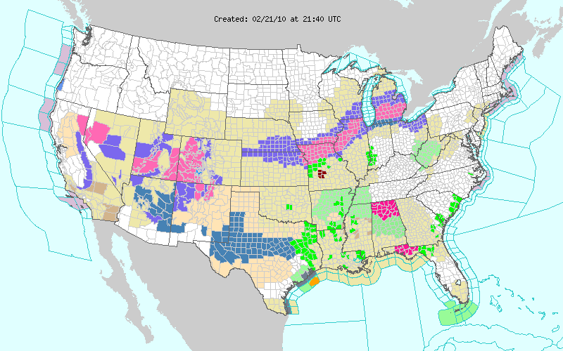
San Angelo has posted up winter storm watches for most of it's area as well as the Midland\Odessa office..
0 likes
The above post and any post by Ntxw is NOT an official forecast and should not be used as such. It is just the opinion of the poster and may or may not be backed by sound meteorological data. It is NOT endorsed by any professional institution including Storm2k. For official information, please refer to NWS products.
Help support Storm2K!
-
Weatherdude20
Re: Texas winter wx thread (2009-2010)
I can't believe the cut off is Johnson and Ellis county, I would (Just me?  ) definatly extend the Winter Strom watch atleast along and south of I-20. They didn't include DFW.
0 likes
-
srainhoutx

- S2K Supporter

- Posts: 6919
- Age: 68
- Joined: Sun Jan 14, 2007 11:34 am
- Location: Haywood County, NC
- Contact:
Re: Texas winter wx thread (2009-2010)
AREA FORECAST DISCUSSION
NATIONAL WEATHER SERVICE HOUSTON/GALVESTON TX
322 PM CST SUN FEB 21 2010
.DISCUSSION...
SHWR AND ISOLATED TSTM ACTIVITY IS CURRENTLY MOSTLY EAST OF THE
AREA AND OFFSHORE. WILL CARRY A SLIGHT CHC POP FOR EXTREME
EASTERN AREAS FOR EARLY THIS EVENING AND HAVE A CHANCE OFFSHORE.
THE SFC PLOT SHOWS THE DRY LINE HAS ADVANCED TO THE WESTERN EDGE
OF THE CWA AND IT WILL LIKELY PUSH A LITTLE FURTHER EAST THE NEXT
COUPLE OF HOURS AND THEN STALL. A CF WILL MERGE WITH THIS FEATURE
AND PUSH THROUGH THE AREA OVERNIGHT.
ALREADY HAVE DENSE FOG AT GLS AND EXPECT THIS FOG TO PERSIST UNTIL
THE CF PASSAGE IN THE 7-10Z PERIOD. MAY SEE DENSE FOG DEVELOP IN
THE 2ND INLAND TIER COUNTIES LATER THIS EVE...BUT THIS FOG MAY BE
SHORT LIVED WITH THE FRONT EXPECTED TO DISSIPATE THE INLAND FOG
AROUND MIDNIGHT. FOR NOW...WILL HAVE AN ADVISORY FOR THE UPPER
COASTAL COUNTIES AND MONITOR FOR FURTHER EXPANSION IF NECESSARY
LATER THIS EVE.
THE MAIN FORECAST ISSUE IS THE WINTER WEATHER EXPECTED TUE AFT AND
NIGHT ACROSS THE N/NW PORTIONS OF THE AREA. THE LATEST GFS IS
INDICATING THAT WE COULD SEE ACCUMULATIONS OF GREATER THAN AN INCH
ALONG AND NORTH OF A CALDWELL TO TRINITY LINE. MAY SEE
ACCUMULATIONS OF GREATER THAN 2 INCHES A LITTLE FURTHER NORTH THAN
THIS LINE. IT IS ALL GOING TO DEPEND ON WHERE MESOSCALE BANDING
SETS UP. WE HAVE THE LUXURY OF A LITTLE MORE TIME BEFORE DECIDING
ON A WINTER STORM WATCH...BUT THIS IS A POSSIBILITY FOR A FEW OF
OUR N/NW COUNTIES. STAY TUNED. FURTHER SOUTH...WE COULD BE IN AN
ADVISORY SITUATION FOR A MIX OF SNOW AND RAIN. HARD TO DRAW THIS
LINE ATTM.
STILL SUPPORT FROM THE GFS AND NOW THE ECMWF THAT WE WILL HAVE
ANOTHER COASTAL LOW SITUATION FRIDAY WITH ANOTHER SIGNIFICANT
SHRT WV TROF. HAVE BUMPED UP RAIN CHANCES FOR FRIDAY INTO THE CHC
RANGE. 33
0 likes
Carla/Alicia/Jerry(In The Eye)/Michelle/Charley/Ivan/Dennis/Katrina/Rita/Wilma/Ike/Harvey
Member: National Weather Association
Wx Infinity Forums
http://wxinfinity.com/index.php
Facebook.com/WeatherInfinity
Twitter @WeatherInfinity
Member: National Weather Association
Wx Infinity Forums
http://wxinfinity.com/index.php
Facebook.com/WeatherInfinity
Twitter @WeatherInfinity
Re: Texas winter wx thread (2009-2010)
Weatherdude20 wrote:I can't believe the cut off is Johnson and Ellis county, I would (Just me?
Haven't you figured it out by now? FW nws doesn't like to put out winter storm watches for the major two north Texas counties (not once this year) whether blizzard conditions or a foot of snow is on the way lol. Joking aside, based on the models it's a pretty good line right now. I figure wwa might be on the way should the precip shield wane north.
0 likes
The above post and any post by Ntxw is NOT an official forecast and should not be used as such. It is just the opinion of the poster and may or may not be backed by sound meteorological data. It is NOT endorsed by any professional institution including Storm2k. For official information, please refer to NWS products.
Help support Storm2K!
Help support Storm2K!
-
southerngale

- Retired Staff

- Posts: 27418
- Joined: Thu Oct 10, 2002 1:27 am
- Location: Southeast Texas (Beaumont area)
Re:
Ntxw wrote:San Angelo has posted up winter storm watches for most of it's area as well as the Midland\Odessa office..
I have relatives in Brownwood and thanks to Storm2k and the early discussions of the models, I was able to warn my aunt days ago. She has a ranch/farm and has been making preps the past few days. I love this board.
0 likes
Please support Storm2k by making a donation today. It is greatly appreciated! Click here: 
 my Cowboys my Rockets my Astros
my Cowboys my Rockets my Astros-
Weatherdude20
Re: Texas winter wx thread (2009-2010)
Dude.I know. I would love to see them get something right for the 1st time though! 


0 likes
-
srainhoutx
- S2K Supporter
- Posts: 6919
- Age: 68
- Joined: Sun Jan 14, 2007 11:34 am
- Location: Haywood County, NC
- Contact:
Re: Texas winter wx thread (2009-2010)
0 likes
Carla/Alicia/Jerry(In The Eye)/Michelle/Charley/Ivan/Dennis/Katrina/Rita/Wilma/Ike/Harvey
Member: National Weather Association
Wx Infinity Forums
http://wxinfinity.com/index.php
Facebook.com/WeatherInfinity
Twitter @WeatherInfinity
Member: National Weather Association
Wx Infinity Forums
http://wxinfinity.com/index.php
Facebook.com/WeatherInfinity
Twitter @WeatherInfinity
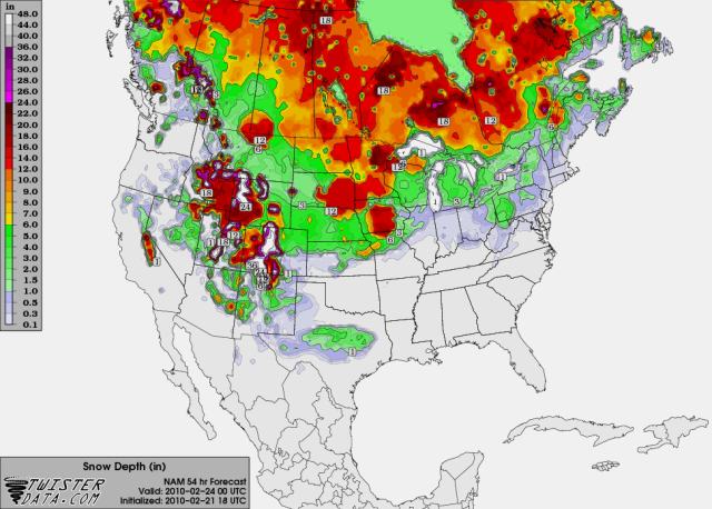
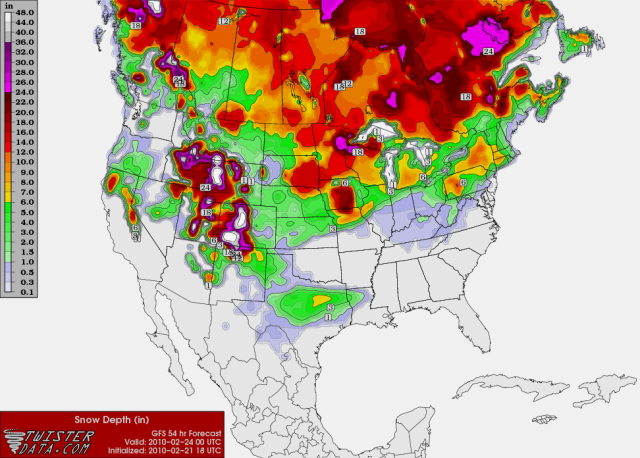
I know it's the 18z, but GFS has a glimmer of hope for North Texas folks. That's what can happen when you're that close to the strike zone. Then again, it can easily leave the next run with a jog to the south and S\E Texas has the opportunity .
S\E Texas.

North Texas.

Heaviest snows based on this run would be just north of Waco, from Hillsboro to Corsicana
S\E Texas.
North Texas.
Heaviest snows based on this run would be just north of Waco, from Hillsboro to Corsicana
Last edited by Ntxw on Sun Feb 21, 2010 5:04 pm, edited 2 times in total.
0 likes
The above post and any post by Ntxw is NOT an official forecast and should not be used as such. It is just the opinion of the poster and may or may not be backed by sound meteorological data. It is NOT endorsed by any professional institution including Storm2k. For official information, please refer to NWS products.
Help support Storm2K!
Help support Storm2K!
-
Texas2Florida

- Tropical Depression
- Posts: 71
- Joined: Thu Dec 03, 2009 12:17 am
- Location: NE Pennsylvania backwoods
Re:
Ntxw wrote:I know it's the 18z, but GFS has a glimmer of hope for North Texas folks. That's what can happen when you're that close to the strike zone. Then again, it can easily leave the next run with a jog to the south and S\E Texas has the opportunity
Oh show it please!
0 likes
Real women wear firesuits! --self proclaimed NASCAR princess.
-
gboudx

- S2K Supporter
- Posts: 4090
- Joined: Thu Sep 04, 2003 1:39 pm
- Location: Rockwall, Tx but from Harvey, La
Only 20% chance of snow for me in Rockwall. Down from 40%. Maybe we'll see some flurries.
I'm linking directly to the site, so the image will change in 24 hours. But here you go. 48 hours out.
http://www.nco.ncep.noaa.gov/pmb/nwprod ... p_048l.gif
Texas2Florida wrote:Ntxw wrote:I know it's the 18z, but GFS has a glimmer of hope for North Texas folks. That's what can happen when you're that close to the strike zone. Then again, it can easily leave the next run with a jog to the south and S\E Texas has the opportunity
Oh show it please!
I'm linking directly to the site, so the image will change in 24 hours. But here you go. 48 hours out.
http://www.nco.ncep.noaa.gov/pmb/nwprod ... p_048l.gif
0 likes
-
Extremeweatherguy

- Category 5

- Posts: 11095
- Joined: Mon Oct 10, 2005 8:13 pm
- Location: Florida

-
Storm Tracker SA-CS
- Tropical Depression
- Posts: 97
- Joined: Fri Feb 19, 2010 2:01 pm
- Location: College Station, TX
Re: Texas winter wx thread (2009-2010)
is a coastal trough a good thing if you want more snow in college station?
0 likes
-
Portastorm

- Storm2k Moderator

- Posts: 9954
- Age: 63
- Joined: Fri Jul 11, 2003 9:16 am
- Location: Round Rock, TX
- Contact:
Re: Texas winter wx thread (2009-2010)
My normally conservative NWSFO continues to be ... um ... conservative with their outlook for Tuesday's winter storm. I guess I shouldn't gripe as they at least acknowledge now there will be some accumulation.
--------------
SPECIAL WEATHER STATEMENT
NATIONAL WEATHER SERVICE AUSTIN/SAN ANTONIO TX
326 PM CST SUN FEB 21 2010
326 PM CST SUN FEB 21 2010
...WINTRY WEATHER TUESDAY...
AN UPPER LEVEL LOW PRESSURE SYSTEM OVER IDAHO WILL DIP INTO SOUTH
CENTRAL TEXAS ON TUESDAY. THIS SYSTEM WILL BRING COLDER TEMPERATURES
AND A CHANCE OF WINTRY PRECIPITATION AS AN OVERRUNNING PATTERN
DEVELOPS. THE INITIAL PRECIPITATION TYPE TUESDAY MORNING WILL BE
RAIN WITH A MIX OF RAIN AND SNOW POSSIBLE IN THE NORTHERN HILL
COUNTRY AND EDWARDS PLATEAU. THE RAIN AND SNOW MIX WILL DRIFT
SOUTHWARD THROUGHOUT THE DAY ON TUESDAY REACHING ITS SOUTHERN MOST
EXTENT NEAR HIGHWAY 90 BY LATE TUESDAY AFTERNOON.
ACCUMULATIONS OF 1 TO 2 INCHES ARE POSSIBLE IN LLANO...BURNET AND
WILLIAMSON COUNTIES. ACCUMULATIONS WILL DECREASE SOUTHWARD FROM AN
INCH POSSIBLE ACROSS NORTHERN TRAVIS COUNTY TO ONE-HALF INCH OVER
NORTHWEST BEXAR COUNTY. PRECIPITATION WILL END FROM WEST TO EAST BY
WEDNESDAY MORNING AS THE UPPER LEVEL LOW PRESSURE SYSTEM QUICKLY
MOVES EASTWARD.
0 likes
Re: Texas winter wx thread (2009-2010)
Storm Tracker SA-CS wrote:is a coastal trough a good thing if you want more snow in college station?
It mostly effects the counties nearest to the coast enhancing their precip chances. You'd be too far away too be impacted much from it as it looks right now.
Last edited by Ntxw on Sun Feb 21, 2010 5:11 pm, edited 1 time in total.
0 likes
The above post and any post by Ntxw is NOT an official forecast and should not be used as such. It is just the opinion of the poster and may or may not be backed by sound meteorological data. It is NOT endorsed by any professional institution including Storm2k. For official information, please refer to NWS products.
Help support Storm2K!
Help support Storm2K!
-
southerngale
- Retired Staff
- Posts: 27418
- Joined: Thu Oct 10, 2002 1:27 am
- Location: Southeast Texas (Beaumont area)
Hey, I think I'm back in the snow on the 18z GFS. lol - but I know I won't see anything but rain. I just keep watching the models because I'd rather skip the more productive things I should be doing, and let it all pile up. 
0 likes
Please support Storm2k by making a donation today. It is greatly appreciated! Click here:
my Cowboys my Rockets my Astros
my Cowboys my Rockets my Astros-
wxman22

- Category 5
- Posts: 1850
- Joined: Mon Jan 30, 2006 12:39 am
- Location: Wichita Falls, TX
- Contact:
Re: Texas winter wx thread (2009-2010)
Storm Tracker SA-CS wrote:is a coastal trough a good thing if you want more snow in college station?
Yes it would be as it would mean more precip lasting longer over Southeast Texas,at the same time you could be too far north to get any benefits from it,it just depends on how strong the trough develops) but of course its the 18z...
Last edited by wxman22 on Sun Feb 21, 2010 5:13 pm, edited 1 time in total.
0 likes
Who is online
Users browsing this forum: No registered users and 95 guests