


Moderator: S2k Moderators
 The posts in this forum are NOT official forecast and should not be used as such. They are just the opinion of the poster and may or may not be backed by sound meteorological data. They are NOT endorsed by any professional institution or STORM2K.


Portastorm wrote::uarrow:
I'm sure you're not seeing anything "cold" looking in the deterministic runs of both the GFS and Euro because there's not much to see. The GFS deterministic (operational) never really showed much cold for later next week to begin with and the Euro has backed off in its last two runs. It's probably more sensible at this point to rely on how the ensemble mean looks and not rely on these deterministic runs, especially with the NWS national desk forecasters regularly chirping about inconsistencies.
I did notice some spread in the individual ensemble members in the 0z GFS but haven't had a chance to see the 12z run.
Regardless, you told us not to rely on any model beyond 3-4 days ... so I'm sticking to that!


wxman57 wrote:12Z Euro ensembles are in. No significant cold from Texas to southern Canada the first week of March. Polar vortex well NE of Hudson Bay and steadily weakening by days 10-15. Zonal flow prevails across the U.S. Temps normal to a little below normal next Wed-Fri followed by gradual warming. Highs across central to east Texas in the 70s to 80 the first week of March. Plenty of time for additional cold fronts (at least one per week) through April, but the snow to our north should be steadily melting in the coming weeks. In addition, days are getting longer and the sun is increasing in elevation.
Ntxw wrote:Geez wxman57 where are you getting all this zonal flow from the ensembles?! I still see below normal heights over Texas almost the entire way and ridging in the NE US moving into Hudson bay as west -NAO, still above normal heights over Alaska, how does that equate to zonal flo??? Split flow, yes
TexasStorm wrote:DFW Airport officially hit 81 degrees today.

orangeblood wrote:Ntxw wrote:Geez wxman57 where are you getting all this zonal flow from the ensembles?! I still see below normal heights over Texas almost the entire way and ridging in the NE US moving into Hudson bay as west -NAO, still above normal heights over Alaska, how does that equate to zonal flo??? Split flow, yes
To me, it appears like he's right....Euro Ensembles show majority of the flow coming out of the eastern Pacific directly across the US, not much of a NE Pacific ridge in place either. I'm afraid Pacific Air is about to take over this pattern towards the end of the month


JDawg512 wrote:Coldest I see is mid 60s for highs next week, still no significant rain yet and a fire weather watch on Thursday. I don't like the situation at all. The downside to this winter is its created a lot of dead and dry tender and a good widespread rain is something that we could really use right about now.


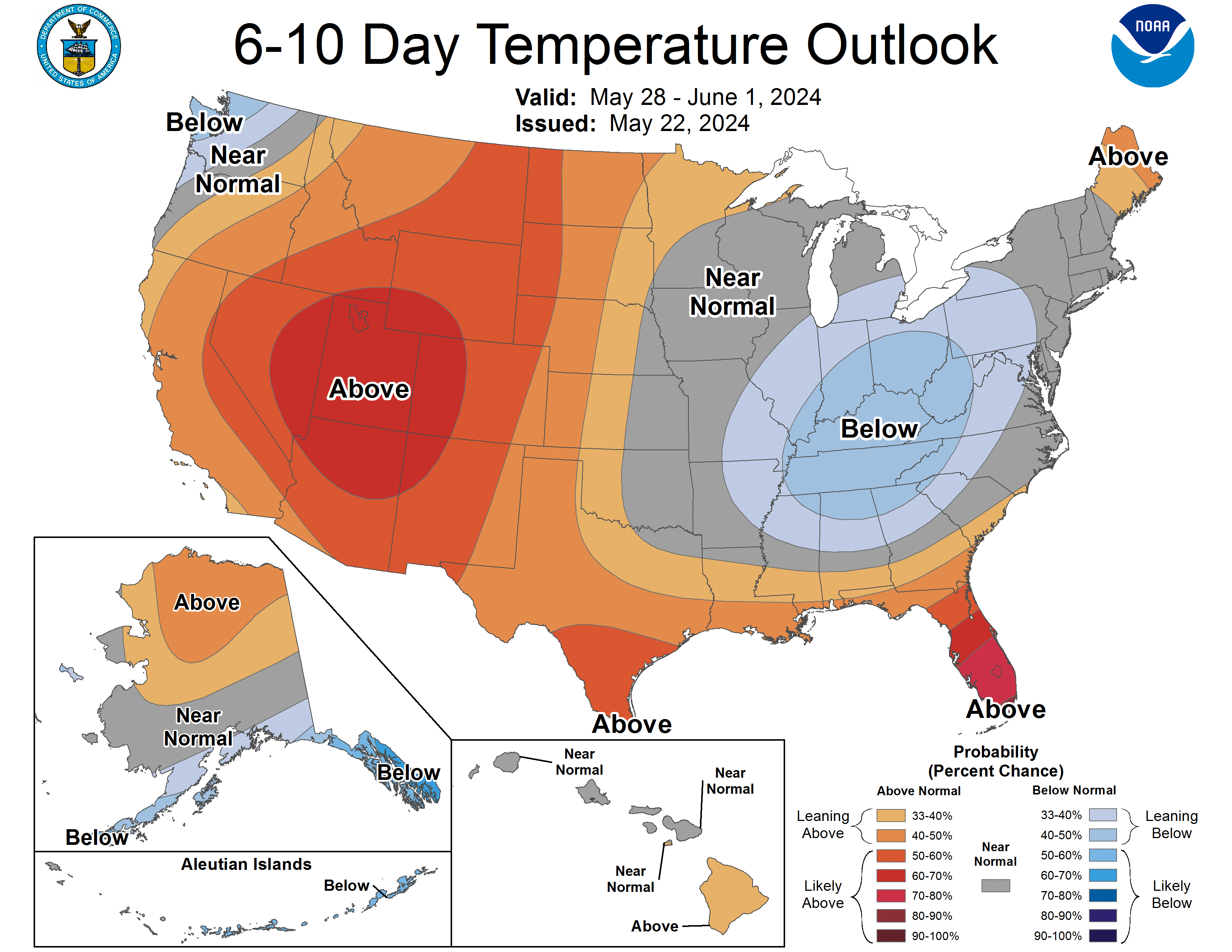
Texas Snowman wrote:These guys sure aren't seeing a zonal flow. This was issued today and is for 2/24 to 2/28.
Users browsing this forum: No registered users and 91 guests


