Texas Winter 2013-2014
Moderator: S2k Moderators
Forum rules
 The posts in this forum are NOT official forecast and should not be used as such. They are just the opinion of the poster and may or may not be backed by sound meteorological data. They are NOT endorsed by any professional institution or STORM2K.

The posts in this forum are NOT official forecast and should not be used as such. They are just the opinion of the poster and may or may not be backed by sound meteorological data. They are NOT endorsed by any professional institution or STORM2K.

The daily EPO has gone negative. Lets see how low and how long it remains in negative territory
0 likes
The above post and any post by Ntxw is NOT an official forecast and should not be used as such. It is just the opinion of the poster and may or may not be backed by sound meteorological data. It is NOT endorsed by any professional institution including Storm2k. For official information, please refer to NWS products.
Help support Storm2K!

Re: Texas Winter 2013-2014
wxman57 wrote:On my bike ride yesterday I saw a number of dogwood trees in full bloom. You can tell they're dogwoods by their bark.
HAW!!!!!!
0 likes
The above post and any post by dhweather is NOT an official forecast and should not be used as such. It is just the opinion of the poster and may or may not be backed by sound meteorological data. It is NOT endorsed by any professional institution including storm2k.org. For official information, please refer to NWS products.
-
wxman57

- Moderator-Pro Met

- Posts: 23170
- Age: 68
- Joined: Sat Jun 21, 2003 8:06 pm
- Location: Houston, TX (southwest)
Re: Texas Winter 2013-2014
Models continue to back away from any significant cold over the next 2 weeks. Perhaps a light freeze in Dallas-Ft. Worth Wed/Thu of this week and again near the middle of next week. Euro ensembles indicate steadily warming 850mb temps from Texas to NW Canada in the 7-15 day time frame. Above-normal temps, in fact. The colder Canadian has snow in northern to central OK over the next week but nothing south of the Red River. Winter's last gasp will last about another week across Texas.
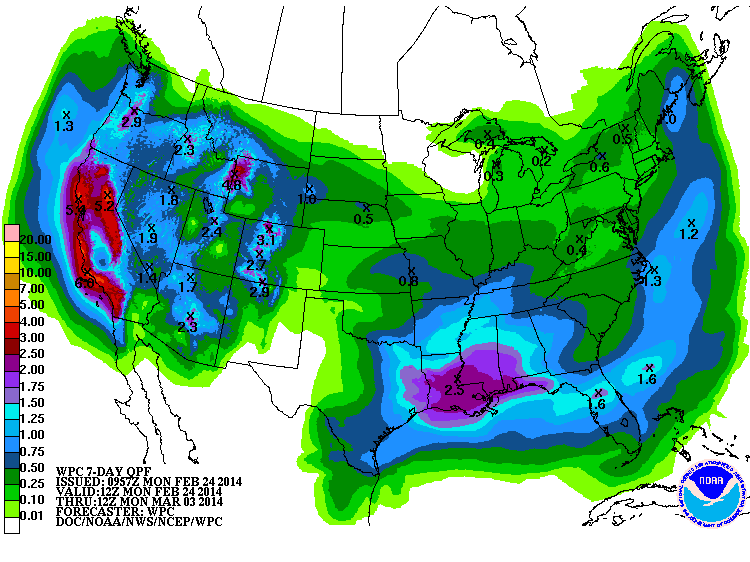
Euro is indicating 1-2" of rain across the Dallas/Ft. Worth area tomorrow and Wednesday and 5-7" from Houston to the FL Panhandle over the next week.
Euro is indicating 1-2" of rain across the Dallas/Ft. Worth area tomorrow and Wednesday and 5-7" from Houston to the FL Panhandle over the next week.
0 likes
-
TeamPlayersBlue

- Category 5

- Posts: 3524
- Joined: Tue Feb 02, 2010 1:44 am
- Location: Denver/Applewood, CO
Eeek, gonna put my rain gauge to the test. Hasnt had a true test yet this winter so im excited to get a washout soon.
0 likes
Personal Forecast Disclaimer:
The posts in this forum are NOT official forecast and should not be used as such. They are just the opinion of the poster and may or may not be backed by sound meteorological data. They are NOT endorsed by any professional institution or storm2k.org. For official information, please refer to the NHC and NWS products.
The posts in this forum are NOT official forecast and should not be used as such. They are just the opinion of the poster and may or may not be backed by sound meteorological data. They are NOT endorsed by any professional institution or storm2k.org. For official information, please refer to the NHC and NWS products.
Models continue to show below normal heights over Texas and the southern plains as the Pacific jet remains active. CFSv2 keeps most of us below average through the first two weeks of March. Below normal heights typically means below average and or wet/damp. NAM and CMC extent suggest light precipitation may occur after frontal passage later this week in N/NW/W TX with HPC showing some probably of ZR or IP south of the Red River. Several storms will come on the heels of the pattern change from last week. No signs of a mild spring as the analogs and 5h flow still do not support sustained above normal temps.
We should have a pretty good idea whether or not El Nino is coming (odds favor one) within the next month or two, exciting times!
We should have a pretty good idea whether or not El Nino is coming (odds favor one) within the next month or two, exciting times!
Last edited by Ntxw on Mon Feb 24, 2014 9:38 am, edited 1 time in total.
0 likes
The above post and any post by Ntxw is NOT an official forecast and should not be used as such. It is just the opinion of the poster and may or may not be backed by sound meteorological data. It is NOT endorsed by any professional institution including Storm2k. For official information, please refer to NWS products.
Help support Storm2K!
Help support Storm2K!
-
srainhoutx

- S2K Supporter

- Posts: 6919
- Age: 68
- Joined: Sun Jan 14, 2007 11:34 am
- Location: Haywood County, NC
- Contact:
Re: Texas Winter 2013-2014
Morning Update from Jeff:
Strong cold front will bring much colder air and high rain chances to the region.
Current ill defined frontal boundary lying across the area with dense sea fog once again in place along the coast and spreading inland to I-10. Boundary appeared to have moved through the I-10 corridor around 400am and now appears to have backed northward allowing sea fog to spread back inland. Visibilities have been going down most of the morning from US 59 southward. Think it may be hard to clear out the sea fog on the coast today unless a better push of drier air moves down from the NNE and this is looking suspect at the moment.
Bigger item of interest is the incoming strong frontal boundary Tuesday and potential for some decent wetting rainfall. Shorter term models have trended wetter overnight with amounts adding some hope that the incoming system may in fact generate some short term drought relief over the region. Strong frontal boundary will arrive into the region Tuesday afternoon and cross the area Tuesday evening with showers and possibly a thunderstorm developing ahead of the boundary and then potentially widespread rainfall behind the boundary in the cold air. Temperatures will quickly fall from the humid 70’s into the 40’s behind this front as the area receives a glancing blow of arctic air. Advancing cold air will end the sea fog threat for the rest of the week after Tuesday.
Looks like rains will continue into Wednesday morning as moisture is brought up and over the surface cold dome. Current model QPF fields along with HPC progs suggest a solid .50 of an inch across the area with isolated totals of 1.0-1.5 inches possible especially toward the coast where rains may linger the longest. Would not rule out a period of cell training of heavier elevation convection at some point Tuesday night which could push totals a little higher in a few narrow bands.
Rains look to end on Wednesday but front stalls not far off the coast and cloud cover will linger. Expect cold temperatures with highs likely in the low 50’s under gusty north winds. Not overly sure the area will see much sun on Thursday or Friday either as SW flow aloft looks to push Pacific moisture toward the area…but will keep rain chances on the low side (20%) for now. Could see a couple of disturbances ride up and out of MX in this flow helping to generate a few showers if there is enough moisture around near the surface. Temperatures will remain below normal for this time of year into Friday before winds turn back to the south.
Active flow pattern aloft continues into next week with some additional rain chances helping to ease some of the building drought across the area.
Next 7-Day Rainfall Amounts:
0 likes
Carla/Alicia/Jerry(In The Eye)/Michelle/Charley/Ivan/Dennis/Katrina/Rita/Wilma/Ike/Harvey
Member: National Weather Association
Wx Infinity Forums
http://wxinfinity.com/index.php
Facebook.com/WeatherInfinity
Twitter @WeatherInfinity
Member: National Weather Association
Wx Infinity Forums
http://wxinfinity.com/index.php
Facebook.com/WeatherInfinity
Twitter @WeatherInfinity
-
Portastorm

- Storm2k Moderator

- Posts: 9954
- Age: 63
- Joined: Fri Jul 11, 2003 9:16 am
- Location: Round Rock, TX
- Contact:
Re: Texas Winter 2013-2014
wxman57 wrote:Models continue to back away from any significant cold over the next 2 weeks. Perhaps a light freeze in Dallas-Ft. Worth Wed/Thu of this week and again near the middle of next week. Euro ensembles indicate steadily warming 850mb temps from Texas to NW Canada in the 7-15 day time frame. Above-normal temps, in fact. The colder Canadian has snow in northern to central OK over the next week but nothing south of the Red River. Winter's last gasp will last about another week across Texas.
Euro is indicating 1-2" of rain across the Dallas/Ft. Worth area tomorrow and Wednesday and 5-7" from Houston to the FL Panhandle over the next week.
Besides your thermostat powers do you also have garden hose spray powers? If so, how about if you aim that hose towards West and South Central Texas please.
0 likes
Any forecasts under my name are to be taken with a grain of salt. Get your best forecasts from the National Weather Service and National Hurricane Center.
-
srainhoutx
- S2K Supporter
- Posts: 6919
- Age: 68
- Joined: Sun Jan 14, 2007 11:34 am
- Location: Haywood County, NC
- Contact:
Re: Texas Winter 2013-2014
Portastorm wrote:wxman57 wrote:Models continue to back away from any significant cold over the next 2 weeks. Perhaps a light freeze in Dallas-Ft. Worth Wed/Thu of this week and again near the middle of next week. Euro ensembles indicate steadily warming 850mb temps from Texas to NW Canada in the 7-15 day time frame. Above-normal temps, in fact. The colder Canadian has snow in northern to central OK over the next week but nothing south of the Red River. Winter's last gasp will last about another week across Texas.
Euro is indicating 1-2" of rain across the Dallas/Ft. Worth area tomorrow and Wednesday and 5-7" from Houston to the FL Panhandle over the next week.
Besides your thermostat powers do you also have garden hose spray powers? If so, how about if you aim that hose towards West and South Central Texas please.
There are indications that a much 'wetter' pattern could develop as that Pacific gets rather active and a series of storms advance E from California across the Desert SW and tap into increasing moisture across the EPAC. The one ingredient we have been missing of late is an active STJ and that appears to be developing as a stout Kelvin Wave translated E across the Pacific allowing deep tropical moisture to stream inland as several Southern track storm systems head toward Texas. We will see.

0 likes
Carla/Alicia/Jerry(In The Eye)/Michelle/Charley/Ivan/Dennis/Katrina/Rita/Wilma/Ike/Harvey
Member: National Weather Association
Wx Infinity Forums
http://wxinfinity.com/index.php
Facebook.com/WeatherInfinity
Twitter @WeatherInfinity
Member: National Weather Association
Wx Infinity Forums
http://wxinfinity.com/index.php
Facebook.com/WeatherInfinity
Twitter @WeatherInfinity
-
weatherdude1108
- Category 5
- Posts: 4228
- Joined: Tue Dec 13, 2011 1:04 pm
- Location: Northwest Austin/Cedar Park, TX
Euro is indicating 1-2" of rain across the Dallas/Ft. Worth area tomorrow and Wednesday and 5-7" from Houston to the FL Panhandle over the next week.[/quote]
Besides your thermostat powers do you also have garden hose spray powers? If so, how about if you aim that hose towards West and South Central Texas please. [/quote]

Yes, please! The EWX has low confidence on the QPF for this next system. Average of less than 1/10 of an inch? The surface of my soil in my yard is developing cracks, the subsurface is still slightly moist. It's as if the heavy rains last October and November never happened.
PREV DISCUSSION... /ISSUED 351 AM CST MON FEB 24 2014/
SHORT TERM (TODAY THROUGH TUESDAY)...
DRIER AIR AT THE SURFACE WILL CONTINUE TO MOVE INTO THE REGION
FROM THE NORTH IN THE WAKE OF YESTERDAY'S FRONT. 09Z SFC OBS
INDICATE DEWPOINTS ARE AS MUCH AS 15 TO 20 DEGREES LOWER COMPARED
TO 24 HRS AGO. HOWEVER...AMPLE MOISTURE THROUGH THE MID-LEVELS
WILL KEEP OVERCAST SKIES ACROSS THE AREA TODAY. PATCHY FOG AND
DRIZZLE REMAIN POSSIBLE MAINLY ACROSS THE COASTAL PLAINS AND NEAR
THE I-35 CORRIDOR THROUGH THE MORNING HOURS. THE FRONT WILL
RETREAT NORTHWARD AS A WARM FRONT TODAY AND TONIGHT. THE SFC
BOUNDARY AND WEAK DISTURBANCES ALOFT SUGGEST THE POTENTIAL FOR
SHOWERS TO DEVELOP TODAY AND TONIGHT...BUT RAINFALL AMOUNTS WILL
BE PALTRY. THE WARM/MOIST ADVECTION WILL ALLOW A MIXED BAG OF
FOG/DRIZZLE/LIGHT RAIN TO DEVELOP TONIGHT AND INTO TUESDAY
MORNING. CHANCES FOR RAIN WILL INCREASE ON TUESDAY AHEAD OF AN
APPROACHING COLD FRONT. DESPITE THE RETURN FLOW PRECEDING THE
FRONT...MODEL CROSS SECTIONS INDICATE GOOD MOISTURE ONLY THROUGH
ABOUT 800-750HPA. RAINFALL TOTALS FOR TUESDAY ARE THEREFORE
EXPECTED TO AVERAGE LESS THAN A TENTH OF AN INCH.
LONG TERM (TUESDAY NIGHT THROUGH SUNDAY)...
THE CHANCE FOR RAIN WILL CONTINUE TUESDAY NIGHT THEN DECREASE ON
WEDNESDAY AS THE FRONT PUSHES THROUGH. ISENTROPIC LIFT IN THE WAKE
OF THE FRONT WILL KEEP SKIES CLOUDY THROUGHOUT THE DAY...WITH A
LINGERING CHANCE FOR LIGHT RAIN ACROSS SRN PORTIONS OF THE CWA.
AFTER SEVERAL DAYS OF SPRING-LIKE TEMPERATURES...THE COLD FRONT
WILL BE A SHARP REMINDER THAT WINTER ISN'T QUITE OVER YET. THE
STRONG COLD AIR ADVECTION AND LACK OF SUNSHINE ON WEDNESDAY WILL
CAP HIGH TEMPERATURES IN THE 40S TO LOW 50S. LOWS THRS MORNING
WILL FALL INTO THE 30S. A FREEZE IS LIKELY FOR THE HILL COUNTRY.
SOUTHERLY FLOW WILL RETURN DURING THE DAY ON THRS AND ALLOW A
QUICK WARMING TREND...HIGHS ON FRIDAY WILL RETURN TO THE UPPER 70S
TO LOW/MID 80S. A RIPPLE IN THE UPPER LEVELS WILL MOVE ACROSS N
TEXAS ON FRIDAY. CHANCES FOR RAIN WITH THIS SYSTEM WILL REMAIN WELL
TO OUR NORTH. ADDITIONALLY...A SURFACE LOW WILL MOVE ACROSS
NRN/NERN TX INTO EAST TX...WHICH WILL ALLOW DRY NW WINDS TO SCOUR
OUT LOW LEVEL MOISTURE ACROSS OUR AREA. THIS DRY SLOTTING WILL
LEAD TO NEAR CRITICAL FIRE WEATHER CONDITIONS ACROSS MUCH OF THE
CWA DURING THE DAY ON FRIDAY. DRY AND COOLER CONDITIONS ARE EXPECTED
OVER THE WEEKEND IN THE WAKE OF THE DRY LINE/WEAK FRONT.
Besides your thermostat powers do you also have garden hose spray powers? If so, how about if you aim that hose towards West and South Central Texas please.
Yes, please! The EWX has low confidence on the QPF for this next system. Average of less than 1/10 of an inch?
The surface of my soil in my yard is developing cracks, the subsurface is still slightly moist. It's as if the heavy rains last October and November never happened. PREV DISCUSSION... /ISSUED 351 AM CST MON FEB 24 2014/
SHORT TERM (TODAY THROUGH TUESDAY)...
DRIER AIR AT THE SURFACE WILL CONTINUE TO MOVE INTO THE REGION
FROM THE NORTH IN THE WAKE OF YESTERDAY'S FRONT. 09Z SFC OBS
INDICATE DEWPOINTS ARE AS MUCH AS 15 TO 20 DEGREES LOWER COMPARED
TO 24 HRS AGO. HOWEVER...AMPLE MOISTURE THROUGH THE MID-LEVELS
WILL KEEP OVERCAST SKIES ACROSS THE AREA TODAY. PATCHY FOG AND
DRIZZLE REMAIN POSSIBLE MAINLY ACROSS THE COASTAL PLAINS AND NEAR
THE I-35 CORRIDOR THROUGH THE MORNING HOURS. THE FRONT WILL
RETREAT NORTHWARD AS A WARM FRONT TODAY AND TONIGHT. THE SFC
BOUNDARY AND WEAK DISTURBANCES ALOFT SUGGEST THE POTENTIAL FOR
SHOWERS TO DEVELOP TODAY AND TONIGHT...BUT RAINFALL AMOUNTS WILL
BE PALTRY. THE WARM/MOIST ADVECTION WILL ALLOW A MIXED BAG OF
FOG/DRIZZLE/LIGHT RAIN TO DEVELOP TONIGHT AND INTO TUESDAY
MORNING. CHANCES FOR RAIN WILL INCREASE ON TUESDAY AHEAD OF AN
APPROACHING COLD FRONT. DESPITE THE RETURN FLOW PRECEDING THE
FRONT...MODEL CROSS SECTIONS INDICATE GOOD MOISTURE ONLY THROUGH
ABOUT 800-750HPA. RAINFALL TOTALS FOR TUESDAY ARE THEREFORE
EXPECTED TO AVERAGE LESS THAN A TENTH OF AN INCH.
LONG TERM (TUESDAY NIGHT THROUGH SUNDAY)...
THE CHANCE FOR RAIN WILL CONTINUE TUESDAY NIGHT THEN DECREASE ON
WEDNESDAY AS THE FRONT PUSHES THROUGH. ISENTROPIC LIFT IN THE WAKE
OF THE FRONT WILL KEEP SKIES CLOUDY THROUGHOUT THE DAY...WITH A
LINGERING CHANCE FOR LIGHT RAIN ACROSS SRN PORTIONS OF THE CWA.
AFTER SEVERAL DAYS OF SPRING-LIKE TEMPERATURES...THE COLD FRONT
WILL BE A SHARP REMINDER THAT WINTER ISN'T QUITE OVER YET. THE
STRONG COLD AIR ADVECTION AND LACK OF SUNSHINE ON WEDNESDAY WILL
CAP HIGH TEMPERATURES IN THE 40S TO LOW 50S. LOWS THRS MORNING
WILL FALL INTO THE 30S. A FREEZE IS LIKELY FOR THE HILL COUNTRY.
SOUTHERLY FLOW WILL RETURN DURING THE DAY ON THRS AND ALLOW A
QUICK WARMING TREND...HIGHS ON FRIDAY WILL RETURN TO THE UPPER 70S
TO LOW/MID 80S. A RIPPLE IN THE UPPER LEVELS WILL MOVE ACROSS N
TEXAS ON FRIDAY. CHANCES FOR RAIN WITH THIS SYSTEM WILL REMAIN WELL
TO OUR NORTH. ADDITIONALLY...A SURFACE LOW WILL MOVE ACROSS
NRN/NERN TX INTO EAST TX...WHICH WILL ALLOW DRY NW WINDS TO SCOUR
OUT LOW LEVEL MOISTURE ACROSS OUR AREA. THIS DRY SLOTTING WILL
LEAD TO NEAR CRITICAL FIRE WEATHER CONDITIONS ACROSS MUCH OF THE
CWA DURING THE DAY ON FRIDAY. DRY AND COOLER CONDITIONS ARE EXPECTED
OVER THE WEEKEND IN THE WAKE OF THE DRY LINE/WEAK FRONT.
0 likes
The preceding post is NOT an official forecast, and should not be used as such. It is only the opinion of the poster and may or may not be backed by sound meteorological data. It is NOT endorsed by any professional institution including storm2k.org. For Official Information please refer to the NHC and NWS products.
-
Lagreeneyes03
- Category 2

- Posts: 608
- Joined: Mon Dec 09, 2013 10:53 am
- Location: Luxurious Lake Grapevine
Re: Texas Winter 2013-2014
After reading here for awhile it seems different posters have different models of favor..one person says above normal temps are coming and winter's last gasp, and another says no indication of any warmer temps through mid March.
Why the big difference?
Why the big difference?
0 likes
I'm a Princess, not a forecaster.

-
TheProfessor

- Professional-Met

- Posts: 3506
- Age: 29
- Joined: Tue Dec 03, 2013 10:56 am
- Location: Wichita, Kansas
Re:
texas1836 wrote:All this rain talk is some welcome news. Is there a Spring thread after the Winter thread is complete? I've always just kept up with Winter.
Yes there is already a spring thread up
0 likes
An alumnus of The Ohio State University.
Your local National Weather Service office is your best source for weather information.
Your local National Weather Service office is your best source for weather information.
-
South Texas Storms

- Professional-Met
- Posts: 4255
- Joined: Thu Jun 24, 2010 12:28 am
- Location: Houston, TX
Re:
texas1836 wrote:All this rain talk is some welcome news. Is there a Spring thread after the Winter thread is complete? I've always just kept up with Winter.
Yeah and there's already a Summer thread too haha!
Here's the link to the Spring thread: http://www.storm2k.org/phpbb2/viewtopic.php?f=24&t=116111&p=2373298#p2373298
0 likes
-
TheProfessor
- Professional-Met
- Posts: 3506
- Age: 29
- Joined: Tue Dec 03, 2013 10:56 am
- Location: Wichita, Kansas
Re: Texas Winter 2013-2014
wxman57 wrote:Models continue to back away from any significant cold over the next 2 weeks. Perhaps a light freeze in Dallas-Ft. Worth Wed/Thu of this week and again near the middle of next week. Euro ensembles indicate steadily warming 850mb temps from Texas to NW Canada in the 7-15 day time frame. Above-normal temps, in fact. The colder Canadian has snow in northern to central OK over the next week but nothing south of the Red River. Winter's last gasp will last about another week across Texas.
Euro is indicating 1-2" of rain across the Dallas/Ft. Worth area tomorrow and Wednesday and 5-7" from Houston to the FL Panhandle over the next week.
You need to spread some of those 5-7" rain totals up to North Texas.
0 likes
An alumnus of The Ohio State University.
Your local National Weather Service office is your best source for weather information.
Your local National Weather Service office is your best source for weather information.
-
wxman57
- Moderator-Pro Met
- Posts: 23170
- Age: 68
- Joined: Sat Jun 21, 2003 8:06 pm
- Location: Houston, TX (southwest)
Re: Texas Winter 2013-2014
Lagreeneyes03 wrote:After reading here for awhile it seems different posters have different models of favor..one person says above normal temps are coming and winter's last gasp, and another says no indication of any warmer temps through mid March.
Why the big difference?
There are no real disagreements. While I love hot weather, I don't see any above-normal temps across Texas through probably next week. Beyond then, it does look like gradually warming temperatures, possible to normal or a little bit above normal by the 2nd week of March. That's not to say temps will be above normal from the 2nd week of March through summer. While I don't expect any more winter weather threats for Dallas/Ft. Worth southward, we'll continue to see cold fronts through April that will drop temperatures to below normal at times. As always, temperatures any given day are rarely "normal". Normal is an average of above-normal temps some days and below-normal other days. And I still think that Houston has seen its last freeze of this winter, at least from Bush Airport southward.
Just looked at the 12z Euro (deterministic & ensembles). Below-normal Wed-Fri across Texas, above-normal this weekend, below-normal next week and above-normal the week after. No winter weather indicated (meaning freezing/frozen precip). Just some cold air. A couple light freezes up in the Dallas area this week and next, none in Houston. Euro indicates 1/2" to an inch of rain across D-FW tomorrow/Wed. Next week's precip is east of there, primarily from Louisiana eastward.
As an example, take a look at the 12Z raw 2-meter temperatures for north Houston (IAH) for the next 192hrs. Note that the "normal" low is 48 and the "normal" high is 69. Given those normals, the next 8 days looks more above-normal than below.

For Dallas-Ft. Worth, the normal low this time of year is in the lower 40s with a high in the lower 60s. Based on the 12Z GFS temperatures below, that area looks a little below normal for the next 8 days, though some days are significantly above normal. That 78F on Friday looks a little suspicious after a 54F high on Thursday. Clearly the GFS is predicting SW flow bringing some warm, dry air in from central Texas.

0 likes
-
Rgv20

- S2K Supporter
- Posts: 2466
- Age: 39
- Joined: Wed Jan 05, 2011 5:42 pm
- Location: Edinburg/McAllen Tx
This morning there were a couple of claps of Thunder, Spring is around the corner! So far I have received 0.24 of liquid gold...next best chance is for Wednesday.
FLOOD ADVISORY
NATIONAL WEATHER SERVICE BROWNSVILLE TX
259 PM CST MON FEB 24 2014
TXC215-427-242200-
/O.NEW.KBRO.FA.Y.0004.140224T2059Z-140224T2200Z/
/00000.0.ER.000000T0000Z.000000T0000Z.000000T0000Z.OO/
HIDALGO-STARR-
259 PM CST MON FEB 24 2014
THE NATIONAL WEATHER SERVICE IN BROWNSVILLE HAS ISSUED AN
* URBAN AND SMALL STREAM FLOOD ADVISORY FOR MINOR FLOODING OF POOR
DRAINAGE AREAS IN...
NORTHWESTERN HIDALGO COUNTY IN DEEP SOUTH TEXAS.
THIS INCLUDES THE CITY OF MCCOOK
EASTERN STARR COUNTY IN DEEP SOUTH TEXAS.
* UNTIL 400 PM CST
* AT 258 PM CST...NATIONAL WEATHER SERVICE METEOROLOGISTS
INDICATED RAINFALL RATES OF ONE TO TWO INCHES PER HOUR FROM
A THUNDERSTORM OVER THE ADVISED AREA.
PRECAUTIONARY/PREPAREDNESS ACTIONS...
DO NOT DRIVE YOUR VEHICLE INTO AREAS WHERE THE WATER COVERS THE ROAD.
THE WATER DEPTH MAY BE TOO GREAT TO ALLOW YOU TO CROSS SAFELY.
DON`T BECOME A STATISTIC. TURN AROUND...DON`T DROWN!
&&
0 likes
The following post is NOT an official forecast and should not be used as such. It is just the opinion of the poster and may or may not be backed by sound meteorological data. It is NOT endorsed by any professional institution including storm2k.org For Official Information please refer to the NHC and NWS products.
This from the San Angelo NWS.........
..possible wintry mix Wednesday...
By Tuesday evening, the cold front will begin moving south, making
it through the Interstate 10 corridor between 9 PM and midnight.
Afternoon showers with some isolated thunderstorms possible may be
ongoing along and north of the frontal boundary. Have kept the
slight chance to chance pops going Tuesday night, mainly for
southern areas. While some storms may be strong, we are not
expecting severe weather.
Much colder air will move in with the cold front than earlier
indicated by model data. The cold air will be pushed south into
the area as surface ridging follows an initial shortwave moving
southeast across the Great Lakes region over the next 48 hours.
However, another shortwave will follow immediately behind,
allowing very cold Canadian air from northern Alberta to be tapped
into, and sent south across the Central Plains. As a result, we
will struggle to get into the upper 30s to near 40 across the
west central Texas Wednesday. At the same time, a weak southern
stream shortwave is expected to move across the area, with enough
lift to generate light precipitation, mainly south of the
Interstate 20 corridor. We have increased precipitation chances
south of a Sterling City to Brownwood line to chance at this time
for Wednesday. Precipitation type is still in question, and we
will likely see a mixed phase once again. Model soundings show a
pronounced warm nose between 850mb and 750mb with temperatures as
warm as 5 degrees celsius. This would melt any ice falling through
that layer. Just below this warm layer at roughly 900mb is a cold
layer with temperatures anywhere from -3 to -6 degrees celsius,
then temperatures warm slightly again to near or just above
freezing at the surface. Given the current data will show a mix of
rain or sleet at this time, however freezing rain cannot be ruled
out just yet. While there is a possibility of wintry precipitation,
only very light accumulations, if any, are expected due to warm
ground temperatures. There is still a lot of uncertainty
associated with this forecast, but this winter weather would
likely cause hazardous travel conditions across parts of the area
Wednesday if it develops.
Wednesday night, temperatures will fall to below freezing which
may impact area roadways further if there is any water leftover on
the roads from previous precipitation.
0 likes
-
Portastorm
- Storm2k Moderator
- Posts: 9954
- Age: 63
- Joined: Fri Jul 11, 2003 9:16 am
- Location: Round Rock, TX
- Contact:
Re: Texas Winter 2013-2014
Yeah natlib ... looks like your area of Texas has a "chance" of seeing some wintry precip.
In its afternoon forecast discussion, NWS Dallas/Fort Worth also mentions this possibility for the southwestern portion of its forecast area (relevant snippet below):
PRECIPITATION WILL COME TO AN END NORTH OF INTERSTATE 20 TUESDAY
EVENING AS MUCH DRIER AIR SPREADS OVERHEAD BEHIND THE FRONT. SOUTH
OF I-20...ANOTHER REGION OF ISENTROPIC ASCENT WILL RAMP UP ONCE AGAIN
WEDNESDAY MORNING AS THE SOUTHERN BRANCH TROUGH MOVES INTO WEST-
CENTRAL TEXAS. TODAY/S MODEL DATA HAS BEEN MORE PRONOUNCED WITH
THIS FEATURE AND IT NOW LOOKS LIKE POPS WILL BE NEEDED OVER THE
SOUTHERN HALF OF NORTH TEXAS FOR WEDNESDAY. TEMPERATURES WILL BE
IN THE LOW TO MID 30S WEDNESDAY MORNING IN THE COLD AIR BEHIND THE
FRONT...AND WILL NOT BE ABLE TO INCREASE MUCH IF AT ALL WITH THICK
CLOUDS AND GOOD COLD AIR ADVECTION. WE HAVE DECIDED TO ADD A MIX
OF RAIN AND SLEET FOR THE SOUTHWESTERN COUNTIES...ROUGHLY SOUTH OF
I-20 AND WEST OF I-35...WHERE THE COLDEST AIR WILL RESIDE. IF ANY
WINTER PRECIPITATION DOES FALL...IT IS NOT EXPECTED TO ACCUMULATE
DUE TO SURFACE TEMPS REMAINING JUST ABOVE FREEZING. EAST OF
I-35...WARMER TEMPERATURES SHOULD KEEP PRECIPITATION IN THE FORM
OF COLD RAIN.
0 likes
Any forecasts under my name are to be taken with a grain of salt. Get your best forecasts from the National Weather Service and National Hurricane Center.
-
TheProfessor
- Professional-Met
- Posts: 3506
- Age: 29
- Joined: Tue Dec 03, 2013 10:56 am
- Location: Wichita, Kansas
-
Lagreeneyes03
- Category 2
- Posts: 608
- Joined: Mon Dec 09, 2013 10:53 am
- Location: Luxurious Lake Grapevine
Re: Texas Winter 2013-2014
wxman57 wrote:Lagreeneyes03 wrote:After reading here for awhile it seems different posters have different models of favor..one person says above normal temps are coming and winter's last gasp, and another says no indication of any warmer temps through mid March.
Why the big difference?
There are no real disagreements. While I love hot weather, I don't see any above-normal temps across Texas through probably next week. Beyond then, it does look like gradually warming temperatures, possible to normal or a little bit above normal by the 2nd week of March. That's not to say temps will be above normal from the 2nd week of March through summer. While I don't expect any more winter weather threats for Dallas/Ft. Worth southward, we'll continue to see cold fronts through April that will drop temperatures to below normal at times. As always, temperatures any given day are rarely "normal". Normal is an average of above-normal temps some days and below-normal other days. And I still think that Houston has seen its last freeze of this winter, at least from Bush Airport southward.
Just looked at the 12z Euro (deterministic & ensembles). Below-normal Wed-Fri across Texas, above-normal this weekend, below-normal next week and above-normal the week after. No winter weather indicated (meaning freezing/frozen precip). Just some cold air. A couple light freezes up in the Dallas area this week and next, none in Houston. Euro indicates 1/2" to an inch of rain across D-FW tomorrow/Wed. Next week's precip is east of there, primarily from Louisiana eastward.
As an example, take a look at the 12Z raw 2-meter temperatures for north Houston (IAH) for the next 192hrs. Note that the "normal" low is 48 and the "normal" high is 69. Given those normals, the next 8 days looks more above-normal than below.
http://home.comcast.net/~cgh57/iahgfs12zfeb24.gif
For Dallas-Ft. Worth, the normal low this time of year is in the lower 40s with a high in the lower 60s. Based on the 12Z GFS temperatures below, that area looks a little below normal for the next 8 days, though some days are significantly above normal. That 78F on Friday looks a little suspicious after a 54F high on Thursday. Clearly the GFS is predicting SW flow bringing some warm, dry air in from central Texas.
http://home.comcast.net/~cgh57/dfwgfs12zfeb24.gif
Thanks for the explanation. Except for that 70 plus degree day it looks pretty darn uncomfortably chilly for the next 10 days or so
0 likes
I'm a Princess, not a forecaster.
Who is online
Users browsing this forum: No registered users and 40 guests