Texas Winter 2024-2025
Moderator: S2k Moderators
Forum rules
 The posts in this forum are NOT official forecast and should not be used as such. They are just the opinion of the poster and may or may not be backed by sound meteorological data. They are NOT endorsed by any professional institution or STORM2K.

The posts in this forum are NOT official forecast and should not be used as such. They are just the opinion of the poster and may or may not be backed by sound meteorological data. They are NOT endorsed by any professional institution or STORM2K.
-
Stratton23
- Category 5

- Posts: 3577
- Joined: Fri Jul 21, 2023 10:59 pm
- Location: Katy, Tx
-
Iceresistance

- Category 5
- Posts: 9608
- Age: 22
- Joined: Sat Oct 10, 2020 9:45 am
- Location: Tecumseh, OK/Norman, OK
Re: Texas Winter 2024-2025
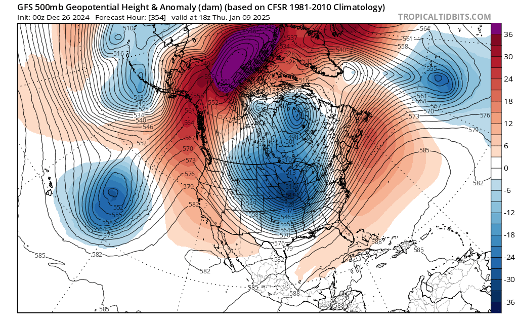
Stratton23 wrote:00z GFS drops the arctic mother-load with a severe - EPO!
Yep, it literally fired the arctic cannon, and it's reloading for another one in that run
2 likes
Bill 2015 & Beta 2020
Winter 2020-2021
All observations are in Tecumseh, OK unless otherwise noted.
Winter posts are focused mainly for Oklahoma & Texas.
Take any of my forecasts with a grain of salt, refer to the NWS, SPC, and NHC for official information
Never say Never with weather! Because ANYTHING is possible!
Winter 2020-2021
All observations are in Tecumseh, OK unless otherwise noted.
Winter posts are focused mainly for Oklahoma & Texas.
Take any of my forecasts with a grain of salt, refer to the NWS, SPC, and NHC for official information
Never say Never with weather! Because ANYTHING is possible!
-
Iceresistance
- Category 5
- Posts: 9608
- Age: 22
- Joined: Sat Oct 10, 2020 9:45 am
- Location: Tecumseh, OK/Norman, OK
Re: Texas Winter 2024-2025
3 likes
Bill 2015 & Beta 2020
Winter 2020-2021
All observations are in Tecumseh, OK unless otherwise noted.
Winter posts are focused mainly for Oklahoma & Texas.
Take any of my forecasts with a grain of salt, refer to the NWS, SPC, and NHC for official information
Never say Never with weather! Because ANYTHING is possible!
Winter 2020-2021
All observations are in Tecumseh, OK unless otherwise noted.
Winter posts are focused mainly for Oklahoma & Texas.
Take any of my forecasts with a grain of salt, refer to the NWS, SPC, and NHC for official information
Never say Never with weather! Because ANYTHING is possible!
-
Sambucol2024
- Tropical Storm

- Posts: 103
- Joined: Mon Feb 26, 2024 1:54 pm
Re: Texas Winter 2024-2025
Stratton23 wrote:00z GFS drops the arctic mother-load with a severe - EPO!
How cold for SETX?
Side note: ERCOT said at the beginning of December that it is probable we will have another Feb 2021 or similar event this winter in Texas.
0 likes

Re: Texas Winter 2024-2025
Iceresistance wrote:Absolutely insane
https://s13.gifyu.com/images/SPfba.png
https://s13.gifyu.com/images/SPfba.png
Good lawd, sweet baby Jesus

0 likes
-
Stratton23
- Category 5
- Posts: 3577
- Joined: Fri Jul 21, 2023 10:59 pm
- Location: Katy, Tx
-
Stratton23
- Category 5
- Posts: 3577
- Joined: Fri Jul 21, 2023 10:59 pm
- Location: Katy, Tx
Re: Texas Winter 2024-2025
Stratton23 wrote:Thats what i call an arctic outbreak
Guess we’ll see what the 00z GEFS says.
2 likes
-
Brent
- S2K Supporter

- Posts: 38777
- Age: 37
- Joined: Sun May 16, 2004 10:30 pm
- Location: Tulsa Oklahoma
- Contact:
Re: Texas Winter 2024-2025
GFS goes from 60 to single digits here
Still fantasy land though
Still fantasy land though
2 likes
#neversummer
-
Stratton23
- Category 5
- Posts: 3577
- Joined: Fri Jul 21, 2023 10:59 pm
- Location: Katy, Tx
Re: Texas Winter 2024-2025
Big time cross polar flow setting up on the 00z GEFS, Cold air is positioned to come straight down into the central plains and texas, not as cold as op run, but very similar setup
3 likes

-
Iceresistance
- Category 5
- Posts: 9608
- Age: 22
- Joined: Sat Oct 10, 2020 9:45 am
- Location: Tecumseh, OK/Norman, OK
Re: Texas Winter 2024-2025
Gotwood wrote:Euro always seems to be a major outlier these days.
Didn't that happen in 2021 and it never ended well for the Euro?
0 likes
Bill 2015 & Beta 2020
Winter 2020-2021
All observations are in Tecumseh, OK unless otherwise noted.
Winter posts are focused mainly for Oklahoma & Texas.
Take any of my forecasts with a grain of salt, refer to the NWS, SPC, and NHC for official information
Never say Never with weather! Because ANYTHING is possible!
Winter 2020-2021
All observations are in Tecumseh, OK unless otherwise noted.
Winter posts are focused mainly for Oklahoma & Texas.
Take any of my forecasts with a grain of salt, refer to the NWS, SPC, and NHC for official information
Never say Never with weather! Because ANYTHING is possible!
-
Stratton23
- Category 5
- Posts: 3577
- Joined: Fri Jul 21, 2023 10:59 pm
- Location: Katy, Tx
Re: Texas Winter 2024-2025
Iceresistance yup, the Euro was absolutely terrible with seeing the cold air coming, failed miserably
0 likes

-
Stratton23
- Category 5
- Posts: 3577
- Joined: Fri Jul 21, 2023 10:59 pm
- Location: Katy, Tx
Re: Texas Winter 2024-2025
Brent yeah the EPS looks like doo doo, GEFS 00z says hold
my beer to the EPS
my beer to the EPS
0 likes
-
Throckmorton
- Tropical Storm
- Posts: 159
- Joined: Mon Jan 09, 2023 6:35 pm
Re: Texas Winter 2024-2025
Some GEFS mean forecasted temperatures in Oklahoma, northern Texas, and Austin for Jan. 9th (12/26, 00Z run). The 90th and 10th forecast percentiles are within parentheses.
42 (67)–25 (06)...Amarillo
54 (72)–38 (27)...Austin Camp Mabry
46 (69)–34 (22)...Dallas
38 (58)–26 (13)...Oklahoma City
36 (53)–26 (11)...Tulsa
42 (67)–25 (06)...Amarillo
54 (72)–38 (27)...Austin Camp Mabry
46 (69)–34 (22)...Dallas
38 (58)–26 (13)...Oklahoma City
36 (53)–26 (11)...Tulsa
0 likes
-
orangeblood
- S2K Supporter
- Posts: 3895
- Joined: Tue Dec 15, 2009 6:14 pm
- Location: Fort Worth, TX
Re: Texas Winter 2024-2025
Really wild discrepancies showing up end of week 2 b/w Euro and GFS Ensembles


0 likes
-
Brent
- S2K Supporter
- Posts: 38777
- Age: 37
- Joined: Sun May 16, 2004 10:30 pm
- Location: Tulsa Oklahoma
- Contact:
Re: Texas Winter 2024-2025
I hate to say it but the EPS usually does better than the GEFS from what I remember
If this pattern gets ruined by the +PNA I have no words anymore
If this pattern gets ruined by the +PNA I have no words anymore
0 likes
#neversummer
-
Tireman4

- S2K Supporter
- Posts: 5904
- Age: 60
- Joined: Fri Jun 30, 2006 1:08 pm
- Location: Humble, Texas
- Contact:
Re: Texas Winter 2024-2025
This could be a bumpy ride for SE Texas. Be weather aware today...
745
FXUS64 KHGX 261015
AFDHGX
Area Forecast Discussion
National Weather Service Houston/Galveston TX
415 AM CST Thu Dec 26 2024
...New SHORT TERM, LONG TERM, AVIATION, MARINE...
.SHORT TERM...
(Today through Friday Night)
Issued at 415 AM CST Thu Dec 26 2024
In advance of a mid-upper trough, a surface low pressure area will
develop in northwest Texas and track ene toward the ArkLaTex
today. A strengthening 35-50kt low level jet will transport deeper
Gulf moisture into the region with PW`s climbing to 1.4-1.6"
(abnormally high for this time of year). Expect scattered showers
early this morning to transition into thunderstorms and increase
in areal coverage late this morning and afternoon with daytime
heating, the approach of the LFQ of an upper jet on the backside
of the mid-upper trough, and a surface trof/front moving toward
the area from the west.
There is a threat of severe weather across all of southeast Texas
today. That being said, latest guidance seems to point toward
areas along and east of a line from roughly Madisonville-Freeport
possibly having the overall most favorable set-up.
Not everyone will see severe storms, but those that do...some
significant impacts are not out of the question. All severe wx modes
are in play:
- Tornadoes: environment will become favorable for discrete rotating
storms especially late morning to late afternoon.
- Hail: cooling mid levels of the atmosphere will enhance updraft
strength and hail growth zone. Hail larger than quarter size
will be likely in the stronger cells.
- Wind damage: strong winds aloft will be prone to mix to the
surface in/near storm downdrafts.
- Heavy rain/flash flooding/rivers: deep moisture is forecast to
be in place as will a somewhat favorable set-up for some storm
training. Several inches of rain could fall in a short time
period leading to some localized issues. Most of the area saw
1-4" of rainfall yesterday which should limit how much the
ground can absorb. Should any storms train over locations that
saw the most significant rains, runoff is more prone to lead to
some street flooding. Though widespread river problems are not
anticipated, we`ll need to keep an eye on rises on some
watersheds.
- Hazardous marine conditions: similar to the
above...hail, wind gusts >34kt, and waterspouts will be a
possibility. Risk probably higher east of Sargent.
Prevalent discrete storms prior to around 5pm should transition to a
more linear mode as the surface front makes its way toward the US59-
I69 corridor late in the day. A thin band of storms will probably
continue southeastward and off the coast sometime around 9pm.
Things should quiet down overnight as the storms pass to the east
and southeast and a drier airmass filters in. Coastal locations
could see some isolated rain chances return late Friday night as
onshore winds gradually bring some moisture back inland. 47
&&
.LONG TERM...
(Saturday through Wednesday)
Issued at 415 AM CST Thu Dec 26 2024
There`s a bit of uncertainty on Saturday in terms of if the
lingering frontal boundary from Thursday`s FROPA is still sitting
nearby in a quasi-stationary state, but either way we are expecting
to be in onshore flow in the warm sector of a developing surface low
near the TX/OK border. This is being pushed by yet another midlevel
shortwave trough that swings through the Southern Plains, but this
one is not expected to be as potent as the one from Christmas Eve
and Thursday. PW values surge to near or above the 90th percentile
(~1.37") ahead of an approaching frontal boundary. While we will
have an axis of instability in place and modest bulk layer shear,
the environment for strong to severe storms looks to be more
favorable to our north and east. That`s not to say that we can`t see
a strong storm or two, but the environment for stronger storms gets
more favorable the further north and east you go. A broken line of
showers/storms is expected to accompany the cold front as it pushes
through Southeast TX, especially as it nears the coast due to
greater moisture availability.
Cooler and drier air filters in behind the front as we trade out our
high temperatures in the mid to upper 70s on Saturday to the upper
60s/low 70s on Sunday. Low temperatures will be in the 40s/50s over
the weekend. Surface high pressure kicks out to the east by late
Sunday allowing for onshore flow to return. We`ll be in more of a
southwesterly flow at the surface and 850mb on Monday along with
drier air in place. 850mb temperatures will reach near the 99th
percentile, so we`ll see some fairly warm temperatures on Monday
with highs in the upper 70s and I wouldn`t be surprised to see some
low 80s as well.
Another midlevel shortwave sweeping through the Central Plains will
generate surface low pressure with a subsequent cold front pushing
into Southeast TX Monday night/Tuesday morning. There won`t be
enough moisture in place for rain chances to return with this FROPA,
but there will be plenty of even cooler and drier air in its wake.
The details are a bit murky, but there looks to be a reinforcing
front some time on New Year`s Day (Wednesday) as well. So, we`ll be
entering 2025 in style with high temperatures generally in the low
60s (some upper 50s mixed in up north) and low temperatures in the
30s/40s. This is good news for those wanting an early look into the
New Year`s Eve (Tuesday) forecast to plan for outdoor activities as
you likely will not need a rain jacket. I say likely because the GFS
is currently the only deterministic model that`s showing some rain
chances...but both the NBM and LREF ensembles show a less than 5%
probability of measurable rainfall around midnight on January 1st. A
jacket is recommended though especially if you`ll be outside for an
extended period of time as we`ll have widespread temperatures in the
40s Tuesday night into Wednesday.
Batiste
&&
.AVIATION...
(12Z TAF Issuance)
Issued at 415 AM CST Thu Dec 26 2024
IFR and LIFR conditions, patchy fog and scattered showers will be
the problem into mid morning. Heading into the late morning and
afternoon, ceilings will lift into a mix of MVFR/VFR territory, but
thunderstorms will develop and increase in coverage...some probably
severe (see above). Overall conditions will improve later this
evening as storms push out of the area. Will however need to keep an
eye on some patchy fog development later tonight with wet ground in
place and lowering wind speeds. 47
&&
.MARINE...
Issued at 415 AM CST Thu Dec 26 2024
Light southerly to southeasterly winds this morning will gradually
increase throughout the day as the next storm system approaches.
These elevated winds warrants at least caution flags into late
tonight. A cold front will accompany this storm system, and there
will be showers and thunderstorms both ahead of and along the
frontal boundary. Some of these storms may become strong to severe
and be capable of producing strong winds, hail, and frequent
lightning. Tornadoes and/or waterspouts cannot be ruled out. The
cold front will push towards the coast by this evening, but is
expected to linger near the coast into Friday. Onshore flow
returns by Friday as the lingering boundary retreats northward. As
a result, rain chances remain in forecast till another cold front
pushes through on Saturday leading to a period of northerly flow
before onshore flow returns again late in the weekend.
Until Saturday`s cold front pushes past the coast, there will be
potential for sea fog during the overnight to early morning hours as
dew points remain in the low to mid 60s paired with water
temperatures in the low 60s.
Batiste
&&
.PRELIMINARY POINT TEMPS/POPS...
College Station (CLL) 72 50 70 53 / 80 10 0 10
Houston (IAH) 74 57 72 60 / 90 60 10 20
Galveston (GLS) 70 62 69 63 / 60 60 10 40
&&
.HGX WATCHES/WARNINGS/ADVISORIES...
TX...None.
GM...Small Craft Should Exercise Caution from noon CST today through
this evening for GMZ330-335.
Small Craft Should Exercise Caution through this evening for
GMZ350-355-370-375.
&&
$$
SHORT TERM...47
LONG TERM....Batiste
AVIATION...47
MARINE...Batiste
0 likes
Re: Texas Winter 2024-2025
orangeblood wrote:Really wild discrepancies showing up end of week 2 b/w Euro and GFS Ensembles
https://images.weatherbell.com/model/ecmwf-ensemble-avg/namer/t2m_f_anom/1735171200/1736467200-z3efN9an1i0.png
https://images.weatherbell.com/model/gfs-ensemble-all-avg/namer/t2m_f_anom/1735171200/1736467200-0QZlYtCciB0.png
I just saw the forecast for the PNA and it’s expected to take a dip towards neutral or even slightly negative over the next 2-3 weeks so I think I’m siding with the GEFS here.
0 likes
Who is online
Users browsing this forum: No registered users and 76 guests