Winter 2010-11 for the Southern Plains
Moderator: S2k Moderators
Forum rules
 The posts in this forum are NOT official forecast and should not be used as such. They are just the opinion of the poster and may or may not be backed by sound meteorological data. They are NOT endorsed by any professional institution or STORM2K.

The posts in this forum are NOT official forecast and should not be used as such. They are just the opinion of the poster and may or may not be backed by sound meteorological data. They are NOT endorsed by any professional institution or STORM2K.
-
TwisterFanatic

- Category 5

- Posts: 1041
- Joined: Mon Jun 28, 2010 12:43 pm
- Location: Sallisaw, Oklahoma
I'm approaching 8 INCHES! Unreal snow rates today. 2" an hour easily.
0 likes
Personal Forecast Disclaimer:
The posts in this forum are NOT official forecast and should not be used as such. They are just the opinion of the poster and may or may not be backed by sound meteorological data. They are NOT endorsed by any professional institution or storm2k.org. For official information, please refer to the NHC and NWS products.
The posts in this forum are NOT official forecast and should not be used as such. They are just the opinion of the poster and may or may not be backed by sound meteorological data. They are NOT endorsed by any professional institution or storm2k.org. For official information, please refer to the NHC and NWS products.
-
Extremeweatherguy

- Category 5
- Posts: 11095
- Joined: Mon Oct 10, 2005 8:13 pm
- Location: Florida
Yeah, it looks like you guys are getting quite the snowfall over there today. 8 inches is definitely a lot of snow!
It's not quite as crazy here today. Mostly just a non-stop light to moderate snow. I haven't measured, but based on the looks of things, I would estimate that we've probably picked up a good 1-2 inches so far. It looks like the bands are back-building somewhat too, so we have more on the way. I could see us easily receiving another 1-2 inches before it is all said and done. Not bad considering the original forecast for today called for only a light dusting.
It's not quite as crazy here today. Mostly just a non-stop light to moderate snow. I haven't measured, but based on the looks of things, I would estimate that we've probably picked up a good 1-2 inches so far. It looks like the bands are back-building somewhat too, so we have more on the way. I could see us easily receiving another 1-2 inches before it is all said and done. Not bad considering the original forecast for today called for only a light dusting.
0 likes
-
wx247

- S2K Supporter

- Posts: 14279
- Age: 42
- Joined: Wed Feb 05, 2003 10:35 pm
- Location: Monett, Missouri
- Contact:
Snowing here, too, with 1-3" now forecasted.
Twister: Congrats on the snow!
Twister: Congrats on the snow!
0 likes
Personal Forecast Disclaimer:
The posts in this forum are NOT official forecast and should not be used as such. They are just the opinion of the poster and may or may not be backed by sound meteorological data. They are NOT endorsed by any professional institution or storm2k.org. For official information, please refer to the NHC and NWS products.
The posts in this forum are NOT official forecast and should not be used as such. They are just the opinion of the poster and may or may not be backed by sound meteorological data. They are NOT endorsed by any professional institution or storm2k.org. For official information, please refer to the NHC and NWS products.
-
TwisterFanatic
- Category 5
- Posts: 1041
- Joined: Mon Jun 28, 2010 12:43 pm
- Location: Sallisaw, Oklahoma
Re:
wx247 wrote:Snowing here, too, with 1-3" now forecasted.
Twister: Congrats on the snow!
I got to much now.
0 likes
Personal Forecast Disclaimer:
The posts in this forum are NOT official forecast and should not be used as such. They are just the opinion of the poster and may or may not be backed by sound meteorological data. They are NOT endorsed by any professional institution or storm2k.org. For official information, please refer to the NHC and NWS products.
The posts in this forum are NOT official forecast and should not be used as such. They are just the opinion of the poster and may or may not be backed by sound meteorological data. They are NOT endorsed by any professional institution or storm2k.org. For official information, please refer to the NHC and NWS products.

Re: Winter 2010-11 for the Southern Plains
Discussion from NWS Norman regarding the potential winter storm middle of next week.
THE 12Z GFS REPRESENTS ONE
EXTREME...WITH A VERY EARLY ARRIVAL OF COLD AIR AND LITTLE
AMPLIFICATION OF THE UPPER WAVE...WHILE THE 12Z ECMWF REPRESENTS
ANOTHER EXTREME...WITH THE SURFACE AND UPPER FEATURES ACTING IN
CONCERT TO GENERATE A STRONG WINTER STORM. WITH THE GFS TENDENCY TO
MOVE SYSTEMS TOO QUICKLY...WE LEANED CLOSER TO THE ECMWF IN
SPREADING HIGH CHANCE POPS AND GREATER WIND SPEEDS INTO WEDNESDAY.
FOLLOWING THE ARCTIC FRONT...REGARDLESS OF THE INTENSITY OF
SNOWFALL...THE COLD AIR IS LIKELY REMAIN IN PLACE THROUGH THE END OF
NEXT WEEK. AGAIN...THE STORM MAY COME INTO BETTER FOCUS OVER THIS
WEEKEND...BUT CERTAINLY BY MONDAY...AS THE UPPER TROUGH MOVES INLAND.
0 likes
-
wx247
- S2K Supporter
- Posts: 14279
- Age: 42
- Joined: Wed Feb 05, 2003 10:35 pm
- Location: Monett, Missouri
- Contact:
New NAM shows nadda... hmm... wonder if this is a trend!
0 likes
Personal Forecast Disclaimer:
The posts in this forum are NOT official forecast and should not be used as such. They are just the opinion of the poster and may or may not be backed by sound meteorological data. They are NOT endorsed by any professional institution or storm2k.org. For official information, please refer to the NHC and NWS products.
The posts in this forum are NOT official forecast and should not be used as such. They are just the opinion of the poster and may or may not be backed by sound meteorological data. They are NOT endorsed by any professional institution or storm2k.org. For official information, please refer to the NHC and NWS products.
-
cheezyWXguy

- Category 5
- Posts: 6281
- Joined: Mon Feb 13, 2006 12:29 am
- Location: Dallas, TX
Re:
wx247 wrote:New NAM shows nadda... hmm... wonder if this is a trend!
For the storm next wednesday? It doesnt even go out that far, but at hour 84 it looks like the storm is out in the western US
0 likes
-
wx247
- S2K Supporter
- Posts: 14279
- Age: 42
- Joined: Wed Feb 05, 2003 10:35 pm
- Location: Monett, Missouri
- Contact:
Re: Re:
cheezyWXguy wrote:wx247 wrote:New NAM shows nadda... hmm... wonder if this is a trend!
For the storm next wednesday? It doesnt even go out that far, but at hour 84 it looks like the storm is out in the western US
No, I was referring to the system coming in tomorrow. Local NWS offices have us at between 50-80% chance of precip, but the NAM prints out next to nothing. I am hoping the 12z changes its tune.
0 likes
Personal Forecast Disclaimer:
The posts in this forum are NOT official forecast and should not be used as such. They are just the opinion of the poster and may or may not be backed by sound meteorological data. They are NOT endorsed by any professional institution or storm2k.org. For official information, please refer to the NHC and NWS products.
The posts in this forum are NOT official forecast and should not be used as such. They are just the opinion of the poster and may or may not be backed by sound meteorological data. They are NOT endorsed by any professional institution or storm2k.org. For official information, please refer to the NHC and NWS products.
Re: Winter 2010-11 for the Southern Plains
Latest run of the GFS (18z) shows a very wide swath of 6-10 inches of snow across OK from Tue-Wed PM, with accumulating snow as far south as DFW. Even gives the Red River counties of Texas upwards of 6 inches of snow. Here we go again! 
0 likes
-
BlueIce
- S2K Supporter
- Posts: 194
- Age: 37
- Joined: Mon Sep 01, 2008 10:05 pm
- Location: Oklahoma City, Oklahoma
Re: Winter 2010-11 for the Southern Plains
natecast wrote:Latest run of the GFS (18z) shows a very wide swath of 6-10 inches of snow across OK from Tue-Wed PM, with accumulating snow as far south as DFW. Even gives the Red River counties of Texas upwards of 6 inches of snow. Here we go again!
I haven't looked at any model data from the CMC or the Euro but if the GFS is still hinting at a decent storm I am sure the other models will start to verify. I'm going to check out the OUN FA discussion and see what their thoughts are on the system.
0 likes
-
Extremeweatherguy
- Category 5
- Posts: 11095
- Joined: Mon Oct 10, 2005 8:13 pm
- Location: Florida
It looks like another high-impact winter weather event is on the way for midweek. Several more inches are possible on top of what has already been a record-snowiest February for Oklahoma City and surrounding areas..
GFS Snowfall amounts: http://wxcaster.com/gis-gfs-snow-overla ... TIONID=TLX
NAM snowfall amounts: http://wxcaster.com/gis-snow-overlays.p ... TIONID=TLX
GFS Snowfall amounts: http://wxcaster.com/gis-gfs-snow-overla ... TIONID=TLX
NAM snowfall amounts: http://wxcaster.com/gis-snow-overlays.p ... TIONID=TLX
0 likes
Re: Winter 2010-11 for the Southern Plains
That's not looking very good for schools on Wed. Maybe it will miss SW OK.
0 likes
-
TwisterFanatic
- Category 5
- Posts: 1041
- Joined: Mon Jun 28, 2010 12:43 pm
- Location: Sallisaw, Oklahoma
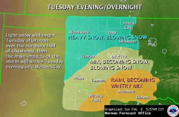
Winter Storm Watch for all of Western Oklahoma including the OKC area.
0 likes
Personal Forecast Disclaimer:
The posts in this forum are NOT official forecast and should not be used as such. They are just the opinion of the poster and may or may not be backed by sound meteorological data. They are NOT endorsed by any professional institution or storm2k.org. For official information, please refer to the NHC and NWS products.
The posts in this forum are NOT official forecast and should not be used as such. They are just the opinion of the poster and may or may not be backed by sound meteorological data. They are NOT endorsed by any professional institution or storm2k.org. For official information, please refer to the NHC and NWS products.
-
cycloneye

- Admin

- Posts: 149275
- Age: 69
- Joined: Thu Oct 10, 2002 10:54 am
- Location: San Juan, Puerto Rico
Re:
TwisterFanatic wrote:Winter Storm Watch for all of Western Oklahoma including the OKC area.
URGENT - WINTER WEATHER MESSAGE
NATIONAL WEATHER SERVICE NORMAN OK
532 PM CST SUN FEB 6 2011
OKZ004>044-046-TXZ083>085-070745-
/O.NEW.KOUN.WS.A.0002.110209T0000Z-110210T0000Z/
HARPER-WOODS-ALFALFA-GRANT-KAY-ELLIS-WOODWARD-MAJOR-GARFIELD-
NOBLE-ROGER MILLS-DEWEY-CUSTER-BLAINE-KINGFISHER-LOGAN-PAYNE-
BECKHAM-WASHITA-CADDO-CANADIAN-OKLAHOMA-LINCOLN-GRADY-MCCLAIN-
CLEVELAND-POTTAWATOMIE-SEMINOLE-HUGHES-HARMON-GREER-KIOWA-JACKSON-
TILLMAN-COMANCHE-STEPHENS-GARVIN-MURRAY-PONTOTOC-COAL-COTTON-
CARTER-HARDEMAN-FOARD-WILBARGER-
INCLUDING THE CITIES OF...BUFFALO...ALVA...CHEROKEE...MEDFORD...
PONCA CITY...ARNETT...WOODWARD...FAIRVIEW...ENID...PERRY...
CHEYENNE...TALOGA...WEATHERFORD...CLINTON...WATONGA...
KINGFISHER...GUTHRIE...STILLWATER...ELK CITY...SAYRE...CORDELL...
ANADARKO...YUKON...EL RENO...MUSTANG...OKLAHOMA CITY...CHANDLER...
CHICKASHA...PURCELL...NORMAN...MOORE...SHAWNEE...SEMINOLE...
HOLDENVILLE...HOLLIS...MANGUM...HOBART...ALTUS...FREDERICK...
LAWTON...DUNCAN...PAULS VALLEY...SULPHUR...ADA...COALGATE...
WALTERS...ARDMORE...QUANAH...CHILLICOTHE...CROWELL...VERNON
532 PM CST SUN FEB 6 2011
...WINTER STORM WATCH IN EFFECT FROM TUESDAY EVENING THROUGH
WEDNESDAY AFTERNOON...
* TIMING: FROM TUESDAY EVENING UNTIL LATE WEDNESDAY AFTERNOON.
* MAIN IMPACT: SNOWFALL AMOUNTS 4 TO 8 INCHES.
PRECAUTIONARY/PREPAREDNESS ACTIONS...
KEEP UP WITH THE LATEST WEATHER INFORMATION...ESPECIALLY IF YOU
PLAN TO TRAVEL.
&&
$$
WR
--------------------------------------------------------------------------------
0 likes
Visit the Caribbean-Central America Weather Thread where you can find at first post web cams,radars
and observations from Caribbean basin members Click Here
and observations from Caribbean basin members Click Here
-
TwisterFanatic
- Category 5
- Posts: 1041
- Joined: Mon Jun 28, 2010 12:43 pm
- Location: Sallisaw, Oklahoma
NAM is wanting to pound Oklahoma again with over a foot of snow.
0 likes
Personal Forecast Disclaimer:
The posts in this forum are NOT official forecast and should not be used as such. They are just the opinion of the poster and may or may not be backed by sound meteorological data. They are NOT endorsed by any professional institution or storm2k.org. For official information, please refer to the NHC and NWS products.
The posts in this forum are NOT official forecast and should not be used as such. They are just the opinion of the poster and may or may not be backed by sound meteorological data. They are NOT endorsed by any professional institution or storm2k.org. For official information, please refer to the NHC and NWS products.
-
TwisterFanatic
- Category 5
- Posts: 1041
- Joined: Mon Jun 28, 2010 12:43 pm
- Location: Sallisaw, Oklahoma
Northeast OK
EDIT: Pretty much the entire northern half of Oklahoma actually.
EDIT: Pretty much the entire northern half of Oklahoma actually.
0 likes
Personal Forecast Disclaimer:
The posts in this forum are NOT official forecast and should not be used as such. They are just the opinion of the poster and may or may not be backed by sound meteorological data. They are NOT endorsed by any professional institution or storm2k.org. For official information, please refer to the NHC and NWS products.
The posts in this forum are NOT official forecast and should not be used as such. They are just the opinion of the poster and may or may not be backed by sound meteorological data. They are NOT endorsed by any professional institution or storm2k.org. For official information, please refer to the NHC and NWS products.

Re: Winter 2010-11 for the Southern Plains
GFS shows less moisture but still a pretty good snow storm for the western half of OK through 72 hours. Wasn't there some sort of recon or better sampling for the 00z run?
0 likes
-
TwisterFanatic
- Category 5
- Posts: 1041
- Joined: Mon Jun 28, 2010 12:43 pm
- Location: Sallisaw, Oklahoma
I think the GFS is under doing the moisture. I also think the NAM might be slightly too high with it.
0 likes
Personal Forecast Disclaimer:
The posts in this forum are NOT official forecast and should not be used as such. They are just the opinion of the poster and may or may not be backed by sound meteorological data. They are NOT endorsed by any professional institution or storm2k.org. For official information, please refer to the NHC and NWS products.
The posts in this forum are NOT official forecast and should not be used as such. They are just the opinion of the poster and may or may not be backed by sound meteorological data. They are NOT endorsed by any professional institution or storm2k.org. For official information, please refer to the NHC and NWS products.


Re: Winter 2010-11 for the Southern Plains
Euro has a lot of snow for OKC and -21.4c (-6) for a low Thurs morning!! Ouch...
0 likes
The above post and any post by Ntxw is NOT an official forecast and should not be used as such. It is just the opinion of the poster and may or may not be backed by sound meteorological data. It is NOT endorsed by any professional institution including Storm2k. For official information, please refer to NWS products.
Help support Storm2K!
Who is online
Users browsing this forum: No registered users and 109 guests