Texas Winter 2014-2015
Moderator: S2k Moderators
Forum rules
 The posts in this forum are NOT official forecast and should not be used as such. They are just the opinion of the poster and may or may not be backed by sound meteorological data. They are NOT endorsed by any professional institution or STORM2K.

The posts in this forum are NOT official forecast and should not be used as such. They are just the opinion of the poster and may or may not be backed by sound meteorological data. They are NOT endorsed by any professional institution or STORM2K.

My first year in Austin was 1983 and I remember the low dropped to 10 degrees during the freeze and it stayed below freezing for about a week. The pipes at my apartment froze. Fortunalely they thawed without bursting.
0 likes
Any opinions stated are those of an amateur, please take with several grains of salt and for official forecast refer to the National Weather Service.


Re: Texas Winter 2014-2015
The ENS lock ridging in place over Alaska. So once the Arctic air starts making a move, at least the lower levels, doesn't look like the pattern will change once it locks in.
McFarland's criteria
1. Anomalous ridging in Alaska/NW NA
2. Hudson Bay-Davis Strait Vortex
3. Zonal flow across the conus overwhelmed by cold
Check those three and you have severe arctic outbreak.
McFarland's criteria
1. Anomalous ridging in Alaska/NW NA
2. Hudson Bay-Davis Strait Vortex
3. Zonal flow across the conus overwhelmed by cold
Check those three and you have severe arctic outbreak.
Last edited by Ntxw on Thu Dec 18, 2014 7:55 pm, edited 1 time in total.
0 likes
The above post and any post by Ntxw is NOT an official forecast and should not be used as such. It is just the opinion of the poster and may or may not be backed by sound meteorological data. It is NOT endorsed by any professional institution including Storm2k. For official information, please refer to NWS products.
Help support Storm2K!
-
TeamPlayersBlue

- Category 5

- Posts: 3530
- Joined: Tue Feb 02, 2010 1:44 am
- Location: Denver/Applewood, CO
Those analogs are insane. Seriously. Esp the 1983 one. The 1979 analog, my dad always described that new years to me. He and my late cousin Buddy went out new years night, came back to a car completely covered in ice in Houston. Then the next day, watched Houston Cougars play Joe Montana and the Fighting Irish in an ice storm in the Cotton bowl. That front looked BRUTAL too.
0 likes
Personal Forecast Disclaimer:
The posts in this forum are NOT official forecast and should not be used as such. They are just the opinion of the poster and may or may not be backed by sound meteorological data. They are NOT endorsed by any professional institution or storm2k.org. For official information, please refer to the NHC and NWS products.
The posts in this forum are NOT official forecast and should not be used as such. They are just the opinion of the poster and may or may not be backed by sound meteorological data. They are NOT endorsed by any professional institution or storm2k.org. For official information, please refer to the NHC and NWS products.
-
orangeblood
- S2K Supporter

- Posts: 3895
- Joined: Tue Dec 15, 2009 6:14 pm
- Location: Fort Worth, TX
Re: Texas Winter 2014-2015
Ntxw wrote:The ENS lock ridging in place over Alaska. So once the Arctic air starts making a move, at least the lower levels, doesn't look like the pattern will change once it locks in.
McFarland's criteria
1. Anomalous ridging in Alaska/NW NA
2. Hudson Bay-Davis Strait Vortex
3. Zonal flow across the conus overwhelmed by cold
Check those three and you have severe arctic outbreak.
If you want to see the potential of this pattern and arctic cold locking in across the lower 48, go check out the 18Z GFS Control Run
0 likes
-
northjaxpro

- S2K Supporter
- Posts: 8900
- Joined: Mon Sep 27, 2010 11:21 am
- Location: Jacksonville, FL
I could ramble on all day long about the historic December 1983 frigid arctic outbreak which gripped the entire CONUS except for the immediate southwestrn U.S. It was the coldest Christmas ever for the country. I remember it like yesterday. It reached 11 degrees in Jax during that cold wave, only to have that record shattered just over 13 months later during the historic January 1985 outbreak when the all-time record low of 7 degrees was recorded at the Jax WFO.
We had three historic arctic outbreaks during the 80s decade, and other than 2010 to a slight magnitude in comparison, we really have not had any more severe arctic outbreaks to the magnitude of those aforementioned in a long time.
We had three historic arctic outbreaks during the 80s decade, and other than 2010 to a slight magnitude in comparison, we really have not had any more severe arctic outbreaks to the magnitude of those aforementioned in a long time.
0 likes
NEVER, EVER SAY NEVER in the tropics and weather in general, and most importantly, with life itself!!
________________________________________________________________________________________
Fay 2008 Beryl 2012 Debby 2012 Colin 2016 Hermine 2016 Julia 2016 Matthew 2016 Irma 2017 Dorian 2019
________________________________________________________________________________________
Fay 2008 Beryl 2012 Debby 2012 Colin 2016 Hermine 2016 Julia 2016 Matthew 2016 Irma 2017 Dorian 2019
-
TeamPlayersBlue
- Category 5
- Posts: 3530
- Joined: Tue Feb 02, 2010 1:44 am
- Location: Denver/Applewood, CO
The big outbreak in 2011, does anyone remember the analogs for that one?
0 likes
Personal Forecast Disclaimer:
The posts in this forum are NOT official forecast and should not be used as such. They are just the opinion of the poster and may or may not be backed by sound meteorological data. They are NOT endorsed by any professional institution or storm2k.org. For official information, please refer to the NHC and NWS products.
The posts in this forum are NOT official forecast and should not be used as such. They are just the opinion of the poster and may or may not be backed by sound meteorological data. They are NOT endorsed by any professional institution or storm2k.org. For official information, please refer to the NHC and NWS products.
Re:
TeamPlayersBlue wrote:The big outbreak in 2011, does anyone remember the analogs for that one?
2011 wasn't anything special at 500mb. It was your classic 500mb progressive ridge poking into Alaska, it didn't sit in Alaska though. Canada had been very very cold (typical in a Nina as that was a strong Nina). So a lot of cold air was in place to be discharged.
The pattern for Arctic outbreaks are often quite similar, as I keep referring to McFarland's set up. The magnitude of the cold depends on how strong the ridging is over the EPO domain, and how cold the air is in front of it. 2011, 1983, 1989, 1962 etc all occurred with a similar trajectory of 500mb ridging. 1983 being the extreme where the blocking sat and exploded.
0 likes
The above post and any post by Ntxw is NOT an official forecast and should not be used as such. It is just the opinion of the poster and may or may not be backed by sound meteorological data. It is NOT endorsed by any professional institution including Storm2k. For official information, please refer to NWS products.
Help support Storm2K!
Help support Storm2K!
-
TheProfessor

- Professional-Met

- Posts: 3506
- Age: 29
- Joined: Tue Dec 03, 2013 10:56 am
- Location: Wichita, Kansas
0 likes
An alumnus of The Ohio State University.
Your local National Weather Service office is your best source for weather information.
Your local National Weather Service office is your best source for weather information.
Re:
TheProfessor wrote::uarrow: What about that week after Christmas in 2009? I remember ponds were freezing over, My friends through a stick at the pond near Cowboy Stadium and instead of going through the ice it bounced and slid across it.
Yes that week was also -EPO/+PNA ridge like in November. However, the moderate Nino had previously flooded Canada with warmer air thus it was not as severe as some of the other outbreaks temperature wise you would expect, but the -NAO kept it around and sure was snowy.

^ That L you see coming down California is the Christmas eve blizzard.
0 likes
The above post and any post by Ntxw is NOT an official forecast and should not be used as such. It is just the opinion of the poster and may or may not be backed by sound meteorological data. It is NOT endorsed by any professional institution including Storm2k. For official information, please refer to NWS products.
Help support Storm2K!
Help support Storm2K!
In all through all these posts, it's pretty simple. The 500mb pattern for discharging Arctic air like the others is about to occur. How much and how strong we won't know until we see it on the move. Is the ridge progressive? Will it sit? How much cold will spill over into Canada?
0 likes
The above post and any post by Ntxw is NOT an official forecast and should not be used as such. It is just the opinion of the poster and may or may not be backed by sound meteorological data. It is NOT endorsed by any professional institution including Storm2k. For official information, please refer to NWS products.
Help support Storm2K!
Help support Storm2K!
-
TeamPlayersBlue
- Category 5
- Posts: 3530
- Joined: Tue Feb 02, 2010 1:44 am
- Location: Denver/Applewood, CO
I noticed in '83, the high was so big that it came down the spine of the rockies under its own weight. 500MB chart looked quite zonal actually.
0 likes
Personal Forecast Disclaimer:
The posts in this forum are NOT official forecast and should not be used as such. They are just the opinion of the poster and may or may not be backed by sound meteorological data. They are NOT endorsed by any professional institution or storm2k.org. For official information, please refer to the NHC and NWS products.
The posts in this forum are NOT official forecast and should not be used as such. They are just the opinion of the poster and may or may not be backed by sound meteorological data. They are NOT endorsed by any professional institution or storm2k.org. For official information, please refer to the NHC and NWS products.
-
orangeblood
- S2K Supporter
- Posts: 3895
- Joined: Tue Dec 15, 2009 6:14 pm
- Location: Fort Worth, TX
Re: Texas Winter 2014-2015
Now, I'm not suggesting we are going to a December 1983 type outbreak but check out the scary similarities to the late December 1983 Northern Hemisphere Upper Levels and those depicted on the latest European ENS mean for late next week...interesting to say the least
1983 December Arctic Outbreak

Late Next Week

1983 December Arctic Outbreak
Late Next Week
0 likes
Re: Texas Winter 2014-2015
orangeblood wrote:Now, I'm not suggesting we are going to a December 1983 type outbreak but check out the scary similarities to the late December 1983 Northern Hemisphere Upper Levels and those depicted on the latest European ENS mean for late next week...interesting to say the least
1983 December Arctic Outbreak
http://www.esrl.noaa.gov/psd/tmp/histda ... .44.10.gif
Late Next Week
http://www.tropicaltidbits.com/analysis ... hem_11.png
Did you see today's Euro weeklies? The ridge sits and bombs 570mb+. I think 83 was 580+. It follows it pretty well sure would be fun to see.
You can look at 1983's ridge progression here below. Look from around the 15th, 20th-25th in sequence
http://www.esrl.noaa.gov/psd/data/20thC ... mages.html
0 likes
The above post and any post by Ntxw is NOT an official forecast and should not be used as such. It is just the opinion of the poster and may or may not be backed by sound meteorological data. It is NOT endorsed by any professional institution including Storm2k. For official information, please refer to NWS products.
Help support Storm2K!
Help support Storm2K!
-
orangeblood
- S2K Supporter
- Posts: 3895
- Joined: Tue Dec 15, 2009 6:14 pm
- Location: Fort Worth, TX
Re: Texas Winter 2014-2015
To srainhoutx's point earlier today....here's a graphical representation, to give everyone a better sense of how much the top analog dates shown on the CPC day 11 Analog Composite mean business....

0 likes
-
Rgv20

- S2K Supporter
- Posts: 2466
- Age: 39
- Joined: Wed Jan 05, 2011 5:42 pm
- Location: Edinburg/McAllen Tx
"15 day forecast of the GFS lol" wxman57 There I said it for you.....now let us have our moment! 


0 likes
The following post is NOT an official forecast and should not be used as such. It is just the opinion of the poster and may or may not be backed by sound meteorological data. It is NOT endorsed by any professional institution including storm2k.org For Official Information please refer to the NHC and NWS products.
-
srainhoutx

- S2K Supporter
- Posts: 6919
- Age: 68
- Joined: Sun Jan 14, 2007 11:34 am
- Location: Haywood County, NC
- Contact:
Re: Texas Winter 2014-2015
Heavy rain with thunder has been ongoing across Metro Houston the past several hours with some isolated flooding issues to the NE in the Piney Woods of East Texas into Louisiana.
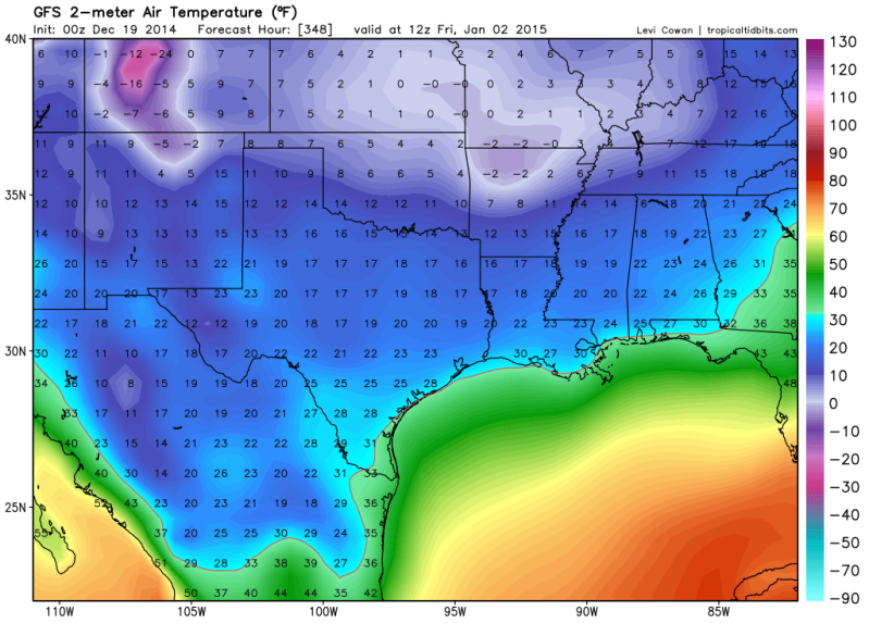
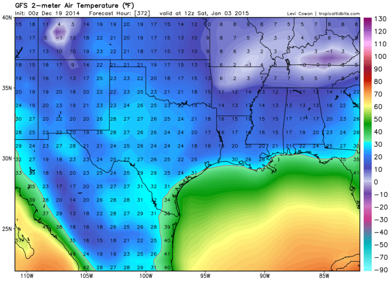
The Global ensembles are still indicating a +PDO/-EPO/+PNA/-AO/-NOA regime develops as a very deep 5H low wraps up near the Great Lakes around Christmas and ushers in a significant pattern change as a strong blocking pattern develops and a cross polar flow brings very cold air south across the Canadian Prairies into the Plains just before the New Year. In fact the 2 meter temperatures for IAH plunge to the upper 20's for daytime highs with lows in the mid to upper teens to around 20F via the 00Z OP GFS in the longer range. If the 500mb charts are correct via the ensembles, a prolonged below freezing period could be possible as January 2015 begins.
The Global ensembles are still indicating a +PDO/-EPO/+PNA/-AO/-NOA regime develops as a very deep 5H low wraps up near the Great Lakes around Christmas and ushers in a significant pattern change as a strong blocking pattern develops and a cross polar flow brings very cold air south across the Canadian Prairies into the Plains just before the New Year. In fact the 2 meter temperatures for IAH plunge to the upper 20's for daytime highs with lows in the mid to upper teens to around 20F via the 00Z OP GFS in the longer range. If the 500mb charts are correct via the ensembles, a prolonged below freezing period could be possible as January 2015 begins.
0 likes
Carla/Alicia/Jerry(In The Eye)/Michelle/Charley/Ivan/Dennis/Katrina/Rita/Wilma/Ike/Harvey
Member: National Weather Association
Wx Infinity Forums
http://wxinfinity.com/index.php
Facebook.com/WeatherInfinity
Twitter @WeatherInfinity
Member: National Weather Association
Wx Infinity Forums
http://wxinfinity.com/index.php
Facebook.com/WeatherInfinity
Twitter @WeatherInfinity
-
wxman57

- Moderator-Pro Met

- Posts: 23174
- Age: 68
- Joined: Sat Jun 21, 2003 8:06 pm
- Location: Houston, TX (southwest)
Re: Texas Winter 2014-2015
I'm not liking what I'm seeing for New Year's. Don't think I'll go on the Houston Bicycle club's New Year's bike ride...

0 likes
-
Ralph's Weather
- S2K Supporter
- Posts: 3371
- Age: 38
- Joined: Fri Dec 13, 2013 11:55 am
- Location: Lindale, TX
- Contact:
Re: Texas Winter 2014-2015
wxman57 wrote:I'm not liking what I'm seeing for New Year's. Don't think I'll go on the Houston Bicycle club's New Year's bike ride...
http://home.comcast.net/~cgh57/iahgfsx0zdec19.gif
Shades of '83 there.
0 likes
Follow on Facebook at Ralph's Weather.
Who is online
Users browsing this forum: No registered users and 41 guests