


March 1-5 or so seems to be the convergence point of the indexes peaking negative.
Moderator: S2k Moderators
 The posts in this forum are NOT official forecast and should not be used as such. They are just the opinion of the poster and may or may not be backed by sound meteorological data. They are NOT endorsed by any professional institution or STORM2K.


srainhoutx wrote:I continue to see the return of chilly and possibly wet weather the first full week of March in the longer range GEFS Ensemble schemes. The Teleconnection Indices continue to advertise a extremely negative Arctic Oscillation and extremely negative North Atlantic Oscillation as a result of the Sudden Stratospheric Warming Event that happen last week. This sort of Northern Hemispheric Blocking pattern is capable of ushering in much colder air across a large expanse of North America including Texas.


gpsnowman wrote:All the rain this week has been awesome. Loved every minute of it. But all good things must end, I'm ready for some sunshine and drier air.

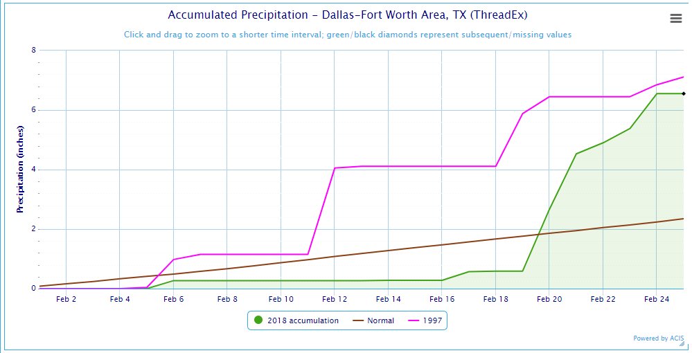
Ntxw wrote:After picking up a little over half inch of rain at DFW this morning, another batch is coming through

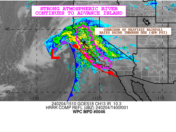
srainhoutx wrote:We folks in S Central and SE Texas will need to monitor the chances of heavy rainfall and possibly some elevated training thunderstorms tonight into Sunday as a very slow moving cool front approach this evening. A skinny line of thunderstorms look to approach our Northern Zones this evening, but a series of embedded disturbances riding along that very noisy sub tropical jet look to cross the SE Texas area tonight where heavy rainfall may focus along and S of the front before transitioning further inland tomorrow morning and possibly throughout the day and evening hours. While widespread flood concerns are minimal, there are suggestions from some of our higher resolution shorter range guidance that some locations could pick up 1-3 inch amounts, possibly higher where training storms do occur. There are a lot of outdoor activities underway with the Rodeo in town, so stay weather aware and have alternate plans should our weather turn wet and stormy.
TeamPlayersBlue wrote:srainhoutx wrote:We folks in S Central and SE Texas will need to monitor the chances of heavy rainfall and possibly some elevated training thunderstorms tonight into Sunday as a very slow moving cool front approach this evening. A skinny line of thunderstorms look to approach our Northern Zones this evening, but a series of embedded disturbances riding along that very noisy sub tropical jet look to cross the SE Texas area tonight where heavy rainfall may focus along and S of the front before transitioning further inland tomorrow morning and possibly throughout the day and evening hours. While widespread flood concerns are minimal, there are suggestions from some of our higher resolution shorter range guidance that some locations could pick up 1-3 inch amounts, possibly higher where training storms do occur. There are a lot of outdoor activities underway with the Rodeo in town, so stay weather aware and have alternate plans should our weather turn wet and stormy.
So i looked at the HRRR and i dont like this type of setup at all for Houston. Boundaries that get stuck over the area with PWAT levels between 1.5 and 1.8. Not good. Love my houston mets too but bad things happen often when they DONT predict them.Not exactly sure how it differs from past events but im kinda worried about this evening. Rodeo is in town, plus, i have a flight to catch at 1030 tomorrow. Lets hope the front movs through the area and doesnt hang around.
For you DFW folk and your snow drought. You poooorrrrr things! ;p I still think you have a snow event coming. Things are looking good in early march for you.


Users browsing this forum: No registered users and 257 guests
