Texas Winter 2011-2012...

Winter Weather Discussion

Moderator: S2k Moderators

Forum rules

The posts in this forum are NOT official forecast and should not be used as such. They are just the opinion of the poster and may or may not be backed by sound meteorological data. They are NOT endorsed by any professional institution or STORM2K.

Help Support Storm2K
Message
Author
User avatar
wxman57
Moderator-Pro Met
Moderator-Pro Met
Posts: 22979
Age: 67
Joined: Sat Jun 21, 2003 8:06 pm
Location: Houston, TX (southwest)

Re:

#961 Postby wxman57 » Mon Dec 12, 2011 2:51 pm

Ntxw wrote:^ Thanks for the input Wxman! I do realize the lack of true arctic air. I guess my thought is maybe one of these SW disturbances might hold together strong enough to generate marginally cold enough air as many during el-nino like storms with lack of the aforementioned. How's your experience so far this winter without the 100s you've been so accustomed to the past summer? :P Seems just like yesterday...


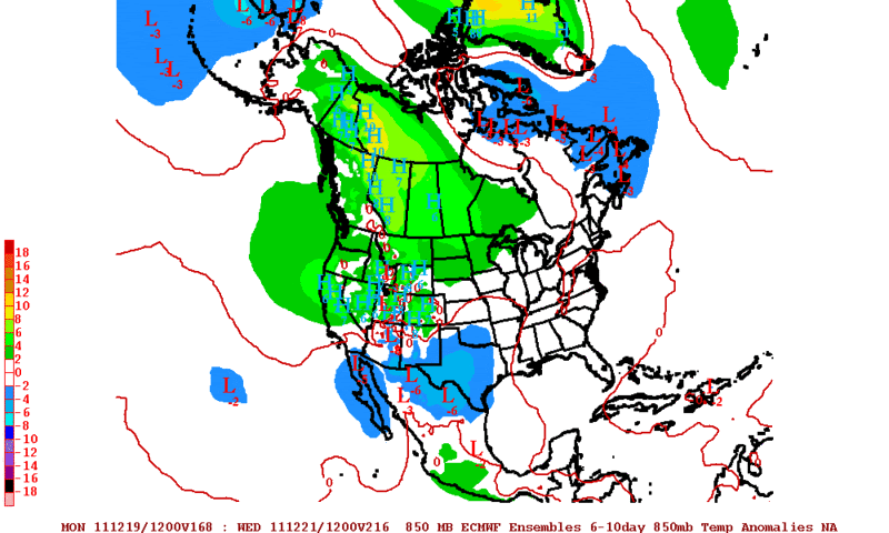
The wife and I went on a 3-hr bike ride yesterday with the temp in the low-mid 50s. We agreed that we'd much rather bike in 100 deg weather than low 50s. Was just looking at the day 10-15 Euro temp forecast for Canada and I see +5F temperature anomalies all over the area for the end of December.
0 likes   

User avatar
TeamPlayersBlue
Category 5
Category 5
Posts: 3445
Joined: Tue Feb 02, 2010 1:44 am
Location: Denver/Applewood, CO

#962 Postby TeamPlayersBlue » Mon Dec 12, 2011 2:55 pm

I think we could still have a big arctic intrusion by Xmas, but if we dont, im thinking that this winter's cold weather will be weighted to the second half of the winter. An example may be like 2007. Fairly warm first part of winter but the beg of 2007 was BRUTALLY cold. I dont have too much to back this up AND THIS SHOULD NOT BE TAKEN AS A FORECAST SINCE IM NOT A METEOROLOGIST, but the cold air is somewhere in the arctic and must come down.
0 likes   
Personal Forecast Disclaimer:
The posts in this forum are NOT official forecast and should not be used as such. They are just the opinion of the poster and may or may not be backed by sound meteorological data. They are NOT endorsed by any professional institution or storm2k.org. For official information, please refer to the NHC and NWS products.

User avatar
Portastorm
Storm2k Moderator
Storm2k Moderator
Posts: 9914
Age: 63
Joined: Fri Jul 11, 2003 9:16 am
Location: Round Rock, TX
Contact:

Re: Texas Winter 2011-2012...

#963 Postby Portastorm » Mon Dec 12, 2011 2:59 pm

FWIW, DT of Wxrisk.com again today talked about the models showing a stratospheric warming event happening later in December and that's often a precursor to a major Arctic outbreak (or cold air buildup). And last night, Larry Cosgrove reiterated his stand that the polar vortex may relocate further south late in the month.

Until then ... more of the same (and hopefully more rain for Texas). But hey, maybe Ntxw can catch some proverbial lightning in a bottle and have a cold-core low move across North Texas and create a little fun and excitement! :D
0 likes   
Any forecasts under my name are to be taken with a grain of salt. Get your best forecasts from the National Weather Service and National Hurricane Center.

User avatar
iorange55
Category 5
Category 5
Posts: 2388
Joined: Thu Nov 13, 2008 9:47 pm
Location: Big D

Re: Texas Winter 2011-2012...

#964 Postby iorange55 » Mon Dec 12, 2011 6:02 pm

At first glance the 18z looks a bit cooler, perhaps.
0 likes   

Brandon8181
S2K Supporter
S2K Supporter
Posts: 424
Age: 41
Joined: Tue Jan 04, 2011 4:52 pm
Location: Tyler, TX
Contact:

Re: Texas Winter 2011-2012...

#965 Postby Brandon8181 » Mon Dec 12, 2011 7:55 pm

Thoughts from the weather service......

BEYOND FRIDAY...GLOBAL MODELS DIVERGE SIGNIFICANTLY WITH THE
HANDLING OF THE SOUTHWEST US UPPER LOW. THE GFS KICKS IT OUT
RATHER QUICKLY WHILE THE ECMWF KEEPS A MUCH SLOWER SYSTEM.
CONFIDENCE IS HIGH THAT THE FRIDAY THROUGH MONDAY TIMEFRAME WILL
SEE PERIODS OF WET WEATHER...BUT TIMING IS QUESTIONABLE. FOR NOW
WILL MAINTAIN 30/40 POPS THROUGH THE END OF THE WEEK AND UPCOMING
WEEKEND AND REFINE AS WE GET CLOSER. THE 12Z ECMWF ALSO MAINTAINS
IT GENERAL IDEA OF THE SLOW MOVING UPPER LOW ACROSS NORTH TEXAS...
ALTHOUGH THIS RUN IS CONSIDERABLY STRONGER WITH THE SYSTEM. THIS
WILL BE IMPORTANT TO WATCH BECAUSE IT COULD BRING SIGNIFICANT
RAINFALL TO THE AREA AND POSES SOME THREAT FOR WINTER WEATHER ON
THE BACK SIDE OF THE UPPER LOW EARLY NEXT WEEK.
0 likes   
I am not a meteorologist. Any post from me should be taken as hobby or fun educational information, but not an accurate source for weather information. Please, refer to your local weather station or National Weather Service for the most up to date information. :flag:

User avatar
vbhoutex
Storm2k Executive
Storm2k Executive
Posts: 29113
Age: 73
Joined: Wed Oct 09, 2002 11:31 pm
Location: Cypress, TX
Contact:

Re:

#966 Postby vbhoutex » Mon Dec 12, 2011 8:26 pm

TeamPlayersBlue wrote:I think we could still have a big arctic intrusion by Xmas, but if we dont, im thinking that this winter's cold weather will be weighted to the second half of the winter. An example may be like 2007. Fairly warm first part of winter but the beg of 2007 was BRUTALLY cold. I dont have too much to back this up AND THIS SHOULD NOT BE TAKEN AS A FORECAST SINCE IM NOT A METEOROLOGIST, but the cold air is somewhere in the arctic and must come down.

I am not disagreeing with you, but cold air does not always come South, it also travels East to West. I've seen it look like we were going to be dumped on for it only to strike a glancing blow at best while freezing out the rest of the country well to the North of TX.
The arctic intrusion is still looking very likely. The question is will it be just before or just after Christmas. What a change from several days ago when some of the models were predicting snow for most of TX, including SE TX. I was hoping for a continued cool down towards Christmas instead of the warmth we are going to see for the rest of this week, at least in SE TX. I have nothing against warmth, but it is Winter?(almost officially)
0 likes   
Skywarn, C.E.R.T.
Please click below to donate to STORM2K to help with the expenses of keeping the site going:
Image

User avatar
iorange55
Category 5
Category 5
Posts: 2388
Joined: Thu Nov 13, 2008 9:47 pm
Location: Big D

Re: Texas Winter 2011-2012...

#967 Postby iorange55 » Mon Dec 12, 2011 8:35 pm

Brandon8181 wrote:Thoughts from the weather service......

BEYOND FRIDAY...GLOBAL MODELS DIVERGE SIGNIFICANTLY WITH THE
HANDLING OF THE SOUTHWEST US UPPER LOW. THE GFS KICKS IT OUT
RATHER QUICKLY WHILE THE ECMWF KEEPS A MUCH SLOWER SYSTEM.
CONFIDENCE IS HIGH THAT THE FRIDAY THROUGH MONDAY TIMEFRAME WILL
SEE PERIODS OF WET WEATHER...BUT TIMING IS QUESTIONABLE. FOR NOW
WILL MAINTAIN 30/40 POPS THROUGH THE END OF THE WEEK AND UPCOMING
WEEKEND AND REFINE AS WE GET CLOSER. THE 12Z ECMWF ALSO MAINTAINS
IT GENERAL IDEA OF THE SLOW MOVING UPPER LOW ACROSS NORTH TEXAS...
ALTHOUGH THIS RUN IS CONSIDERABLY STRONGER WITH THE SYSTEM. THIS
WILL BE IMPORTANT TO WATCH BECAUSE IT COULD BRING SIGNIFICANT
RAINFALL TO THE AREA AND POSES SOME THREAT FOR WINTER WEATHER ON
THE BACK SIDE OF THE UPPER LOW EARLY NEXT WEEK.


Very interesting. I talked with a friend of mine on a different board and he was talking about that same possibility.
0 likes   

Brandon8181
S2K Supporter
S2K Supporter
Posts: 424
Age: 41
Joined: Tue Jan 04, 2011 4:52 pm
Location: Tyler, TX
Contact:

Re: Texas Winter 2011-2012...

#968 Postby Brandon8181 » Mon Dec 12, 2011 8:44 pm

iorange55 wrote:
Brandon8181 wrote:Thoughts from the weather service......

BEYOND FRIDAY...GLOBAL MODELS DIVERGE SIGNIFICANTLY WITH THE
HANDLING OF THE SOUTHWEST US UPPER LOW. THE GFS KICKS IT OUT
RATHER QUICKLY WHILE THE ECMWF KEEPS A MUCH SLOWER SYSTEM.
CONFIDENCE IS HIGH THAT THE FRIDAY THROUGH MONDAY TIMEFRAME WILL
SEE PERIODS OF WET WEATHER...BUT TIMING IS QUESTIONABLE. FOR NOW
WILL MAINTAIN 30/40 POPS THROUGH THE END OF THE WEEK AND UPCOMING
WEEKEND AND REFINE AS WE GET CLOSER. THE 12Z ECMWF ALSO MAINTAINS
IT GENERAL IDEA OF THE SLOW MOVING UPPER LOW ACROSS NORTH TEXAS...
ALTHOUGH THIS RUN IS CONSIDERABLY STRONGER WITH THE SYSTEM. THIS
WILL BE IMPORTANT TO WATCH BECAUSE IT COULD BRING SIGNIFICANT
RAINFALL TO THE AREA AND POSES SOME THREAT FOR WINTER WEATHER ON
THE BACK SIDE OF THE UPPER LOW EARLY NEXT WEEK.


Very interesting. I talked with a friend of mine on a different board and he was talking about that same possibility.


Oranage, it looks like the cold air may follow the low...IF this event pans out I think some areas could see significant snowfall....(isolated)

The following post is NOT an official forecast and should not be used as such. It is just the opinion of the poster and may or may not be backed by sound meteorological data. It is NOT endorsed by any professional institution including storm2k.org For Official Information please refer to the NHC and NWS products.
0 likes   
I am not a meteorologist. Any post from me should be taken as hobby or fun educational information, but not an accurate source for weather information. Please, refer to your local weather station or National Weather Service for the most up to date information. :flag:

User avatar
Rgv20
S2K Supporter
S2K Supporter
Posts: 2466
Age: 39
Joined: Wed Jan 05, 2011 5:42 pm
Location: Edinburg/McAllen Tx

#969 Postby Rgv20 » Mon Dec 12, 2011 9:05 pm

Well the 12zECMWF was an interesting run as it has a rather cool pattern for the early part of next week and a threat of Winter weather for the Northern and Western part of the state. Also it has a wide swath of 4-5'' of rain for Central and Northern Texas thru 10 days...not bad for December :D

12zECMWF Ensembles 850mb Temperatures Anomalies 6-10 days. The Ensemble Mean calls for most of Texas to be below normal temperature wise for the early part of next week.
Image
0 likes   
The following post is NOT an official forecast and should not be used as such. It is just the opinion of the poster and may or may not be backed by sound meteorological data. It is NOT endorsed by any professional institution including storm2k.org For Official Information please refer to the NHC and NWS products.

User avatar
gboudx
S2K Supporter
S2K Supporter
Posts: 4080
Joined: Thu Sep 04, 2003 1:39 pm
Location: Rockwall, Tx but from Harvey, La

#970 Postby gboudx » Mon Dec 12, 2011 9:43 pm

We really need that rain. Bring it!
0 likes   

GRAYSONCO.WX
Category 1
Category 1
Posts: 450
Joined: Thu Jan 06, 2011 4:29 pm
Location: Denison, Texas

Re: Texas Winter 2011-2012...

#971 Postby GRAYSONCO.WX » Mon Dec 12, 2011 10:48 pm

The 00Z NAM shows some cold air arriving at hour 84.
0 likes   

orangeblood
S2K Supporter
S2K Supporter
Posts: 3714
Joined: Tue Dec 15, 2009 6:14 pm
Location: Fort Worth, TX

Re: Texas Winter 2011-2012...

#972 Postby orangeblood » Mon Dec 12, 2011 11:26 pm

GRAYSONCO.WX wrote:The 00Z NAM shows some cold air arriving at hour 84.


And it shows the upper low over SW Utah while the 00Z GFS has it spinning off the coast of San Diego at the same time...Don't know if I've ever seen that big of a discrepancy between those two models.

These models are all over the place with this pattern :x
0 likes   

User avatar
Ntxw
Storm2k Moderator
Storm2k Moderator
Posts: 22786
Joined: Wed Oct 21, 2009 6:34 pm
Location: DFW, Texas

Re: Texas Winter 2011-2012...

#973 Postby Ntxw » Mon Dec 12, 2011 11:37 pm

orangeblood wrote:And it shows the upper low over SW Utah while the 00Z GFS has it spinning off the coast of San Diego at the same time...Don't know if I've ever seen that big of a discrepancy between those two models.

These models are all over the place with this pattern :x


There are just so many storms lined up in the Pacific not to mention the ones coming from upstream. It's tough for the models to time them right, truly amazing. Heck I can't even keep track which storm is which lol.
0 likes   
The above post and any post by Ntxw is NOT an official forecast and should not be used as such. It is just the opinion of the poster and may or may not be backed by sound meteorological data. It is NOT endorsed by any professional institution including Storm2k. For official information, please refer to NWS products.

  Help support Storm2K!
Help Support Storm2K

GRAYSONCO.WX
Category 1
Category 1
Posts: 450
Joined: Thu Jan 06, 2011 4:29 pm
Location: Denison, Texas

Re: Texas Winter 2011-2012...

#974 Postby GRAYSONCO.WX » Mon Dec 12, 2011 11:50 pm

The 00Z GFS looks to be colder than the 18Z run..anybody else seeing this?
0 likes   

User avatar
TwisterFanatic
Category 5
Category 5
Posts: 1041
Joined: Mon Jun 28, 2010 12:43 pm
Location: Sallisaw, Oklahoma

#975 Postby TwisterFanatic » Tue Dec 13, 2011 2:29 am

I like the operational GFS is warmer than average, and the ensembles are colder than average.
0 likes   
Personal Forecast Disclaimer:
The posts in this forum are NOT official forecast and should not be used as such. They are just the opinion of the poster and may or may not be backed by sound meteorological data. They are NOT endorsed by any professional institution or storm2k.org. For official information, please refer to the NHC and NWS products.

BrokenGlassRepublicn
Category 1
Category 1
Posts: 481
Joined: Sun Nov 20, 2011 8:07 pm
Location: Richardson, Texas

Texas Winter 2011-2012...

#976 Postby BrokenGlassRepublicn » Tue Dec 13, 2011 6:23 am

Not a Met, but from the sound of thing, this is shaping up to be the pattern we need to finally get some water back into our lakes. As much as I love winter weather, I'll take the rain right now.
0 likes   

User avatar
Portastorm
Storm2k Moderator
Storm2k Moderator
Posts: 9914
Age: 63
Joined: Fri Jul 11, 2003 9:16 am
Location: Round Rock, TX
Contact:

Re:

#977 Postby Portastorm » Tue Dec 13, 2011 12:06 pm

gboudx wrote:We really need that rain. Bring it!


Never did I imagine that with the projected La Nina this winter and the terrible, ongoing drought that I would be looking at a 7-day forecast for Austin in early December 2011 and see rain in the forecast for several single day!

It's awesome! Yes, bring the rain.

And as I've been saying, apparently not all La Ninas are alike.
0 likes   
Any forecasts under my name are to be taken with a grain of salt. Get your best forecasts from the National Weather Service and National Hurricane Center.

User avatar
TeamPlayersBlue
Category 5
Category 5
Posts: 3445
Joined: Tue Feb 02, 2010 1:44 am
Location: Denver/Applewood, CO

#978 Postby TeamPlayersBlue » Tue Dec 13, 2011 5:09 pm

"Hmmm...12z ECMWF model has a storm along the the Gulf Coast on Christmas Eve. In an amplifying 500MB pattern. Let us pray for a winter storm..." - Larry Cosgrove via Facebook.... Dont you tease me like that!!!!!!
0 likes   
Personal Forecast Disclaimer:
The posts in this forum are NOT official forecast and should not be used as such. They are just the opinion of the poster and may or may not be backed by sound meteorological data. They are NOT endorsed by any professional institution or storm2k.org. For official information, please refer to the NHC and NWS products.

User avatar
Portastorm
Storm2k Moderator
Storm2k Moderator
Posts: 9914
Age: 63
Joined: Fri Jul 11, 2003 9:16 am
Location: Round Rock, TX
Contact:

Re:

#979 Postby Portastorm » Tue Dec 13, 2011 5:15 pm

TeamPlayersBlue wrote:"Hmmm...12z ECMWF model has a storm along the the Gulf Coast on Christmas Eve. In an amplifying 500MB pattern. Let us pray for a winter storm..." - Larry Cosgrove via Facebook.... Dont you tease me like that!!!!!!


Sorry bud ... the "storm" to which he is referring would really be more of a player for the Central Gulf Coast and then up into the interior Northeast. It doesn't show any wintry precip for your area. Or mine for that matter.

Here is the 500mb map from the 12z Euro at 240 hours:

Image

Uploaded with ImageShack.us
0 likes   
Any forecasts under my name are to be taken with a grain of salt. Get your best forecasts from the National Weather Service and National Hurricane Center.

User avatar
TeamPlayersBlue
Category 5
Category 5
Posts: 3445
Joined: Tue Feb 02, 2010 1:44 am
Location: Denver/Applewood, CO

#980 Postby TeamPlayersBlue » Tue Dec 13, 2011 5:24 pm

Grrr.... Well looks like i misunderstood him. I dont see any cold air coming down for a bit though. Didn t have the resources to check the Euro for myself. Over/under 65 degrees for xmas? :/
0 likes   
Personal Forecast Disclaimer:
The posts in this forum are NOT official forecast and should not be used as such. They are just the opinion of the poster and may or may not be backed by sound meteorological data. They are NOT endorsed by any professional institution or storm2k.org. For official information, please refer to the NHC and NWS products.


Return to “Winter Weather”

Who is online

Users browsing this forum: No registered users and 9 guests