Texas Winter 2012-2013

Winter Weather Discussion

Moderator: S2k Moderators

Forum rules

The posts in this forum are NOT official forecast and should not be used as such. They are just the opinion of the poster and may or may not be backed by sound meteorological data. They are NOT endorsed by any professional institution or STORM2K.

Help Support Storm2K
Message
Author
SaskatchewanScreamer

#961 Postby SaskatchewanScreamer » Mon Dec 17, 2012 9:55 pm

Saturday Dec. 22/12
Forecast for Moose Jaw, Saskatchewan

Scattered fluries
POP 40%

High -17
Feels like -27
Low -21
:rarrow: Wind from the N.W. 15 km/h

Now I'm no expert but it seems when we have a wind from the Northwest you folks seem to do well (hope it is right and the blocking out there is in the right place). Good luck re your White Christmas! :D
0 likes   

User avatar
ludosc
Tropical Storm
Tropical Storm
Posts: 161
Age: 40
Joined: Tue Dec 29, 2009 3:44 pm
Location: Midlothian, TX

Re:

#962 Postby ludosc » Mon Dec 17, 2012 10:37 pm

SaskatchewanScreamer wrote:Saturday Dec. 22/12
Forecast for Moose Jaw, Saskatchewan

Scattered fluries
POP 40%

High -17
Feels like -27
Low -21
:rarrow: Wind from the N.W. 15 km/h

Now I'm no expert but it seems when we have a wind from the Northwest you folks seem to do well (hope it is right and the blocking out there is in the right place). Good luck re your White Christmas! :D


i need to move to Saskatchewan....
0 likes   

User avatar
Portastorm
Storm2k Moderator
Storm2k Moderator
Posts: 9914
Age: 63
Joined: Fri Jul 11, 2003 9:16 am
Location: Round Rock, TX
Contact:

Re: Texas Winter 2012-2013

#963 Postby Portastorm » Mon Dec 17, 2012 10:47 pm

TeamPlayersBlue wrote:
orangeblood wrote:Anyone checked out the 18Z GFS ensembles yet ?? :cold: :cold: For the 1st time this year it pumps the Alaskan Ridge and opens the Siberian Express up to spill straight down into the snow covered Plains. The ensemble mean suggest temps some 15-25 F below normal towards the beginning of the new year. If the mean is already showing this, there are some very extreme members showing temps we haven't seen in a long long time. IMO, this does seems plausible considering the extreme cold across Eastern Siberia at this time.

Buckle up, this could be a wild ride coming up over the next few weeks!!


The following post is NOT an official forecast and should not be used as such. It is just the opinion of the poster and may or may not be backed by sound meteorological data. It is NOT endorsed by any professional institution including storm2k.org. For official information, please refer to NWS products.


Its been very cold in that region for a very long time. It has to go somewhere.


Actually, it doesn't. Last winter the frigid cold stayed in portions of Europe and Eurasia. Never came over to this side of the globe. We shall see.
0 likes   
Any forecasts under my name are to be taken with a grain of salt. Get your best forecasts from the National Weather Service and National Hurricane Center.

User avatar
Ntxw
Storm2k Moderator
Storm2k Moderator
Posts: 22786
Joined: Wed Oct 21, 2009 6:34 pm
Location: DFW, Texas

Re: Texas Winter 2012-2013

#964 Postby Ntxw » Mon Dec 17, 2012 11:21 pm

I like what I'm seeing from the 0z GFS, 1052 building high in Canada and no northern stream to sap energy away. This beast is going to amplify way south, I haven't felt so good about a storm this far out in a long time.
0 likes   
The above post and any post by Ntxw is NOT an official forecast and should not be used as such. It is just the opinion of the poster and may or may not be backed by sound meteorological data. It is NOT endorsed by any professional institution including Storm2k. For official information, please refer to NWS products.

  Help support Storm2K!
Help Support Storm2K

User avatar
Portastorm
Storm2k Moderator
Storm2k Moderator
Posts: 9914
Age: 63
Joined: Fri Jul 11, 2003 9:16 am
Location: Round Rock, TX
Contact:

Re: Texas Winter 2012-2013

#965 Postby Portastorm » Mon Dec 17, 2012 11:23 pm

Ntxw wrote:I like what I'm seeing from the 0z GFS, 1052 building high in Canada and no northern stream to sap energy away. This beast is going to amplify way south, I haven't felt so good about a storm this far out in a long time.


Heh, I bet that's why we are all online at the moment ... that 0z GFS run! :lol:

I noticed that high being a bit stronger than what the 12z showed. Also did you notice -- at least thru 162 hours -- that the 500mb trough over the Rockies is deeper on this 0z run than it was on the 12z run? That means this 0z run is trending more towards the Euro solution thus far.
0 likes   
Any forecasts under my name are to be taken with a grain of salt. Get your best forecasts from the National Weather Service and National Hurricane Center.

User avatar
vbhoutex
Storm2k Executive
Storm2k Executive
Posts: 29113
Age: 73
Joined: Wed Oct 09, 2002 11:31 pm
Location: Cypress, TX
Contact:

Re: Texas Winter 2012-2013

#966 Postby vbhoutex » Mon Dec 17, 2012 11:26 pm

Models continue to offer hope for beyond Christmas in the way of cold air and maybe precipitation. Near to mid term it appears there is a good chance of a snow pack being laid down between TX and Canada which would be a good precursor to the Arctic cold that it appears will be spilling our way in the days between Christmas and New Years. At this point, at the most it appears precipitation in SE TX will be of the liquid type.(Some areas of N and C TX may be luckier.) There is time for this to change, but I wouldn't hold my breath on any of this until we get a lot closer. Raise my hopes? Sure. Take it to the bank for a loan? No way.
0 likes   
Skywarn, C.E.R.T.
Please click below to donate to STORM2K to help with the expenses of keeping the site going:
Image

User avatar
iorange55
Category 5
Category 5
Posts: 2388
Joined: Thu Nov 13, 2008 9:47 pm
Location: Big D

Re: Texas Winter 2012-2013

#967 Postby iorange55 » Mon Dec 17, 2012 11:30 pm

You all beat me to it! Definitely a step in the right direction with this run so far. A little deeper and a little colder...I don't want to get my hopes up, but it sure is looking like this could be the "real deal" as that chef with the weird hair might say.

Just have to work out the timing and the precip chances.
0 likes   

User avatar
Ntxw
Storm2k Moderator
Storm2k Moderator
Posts: 22786
Joined: Wed Oct 21, 2009 6:34 pm
Location: DFW, Texas

Re: Texas Winter 2012-2013

#968 Postby Ntxw » Mon Dec 17, 2012 11:30 pm

Portastorm wrote:Heh, I bet that's why we are all online at the moment ... that 0z GFS run! :lol:

I noticed that high being a bit stronger than what the 12z showed. Also did you notice -- at least thru 162 hours -- that the 500mb trough over the Rockies is deeper on this 0z run than it was on the 12z run? That means this 0z run is trending more towards the Euro solution thus far.


Most certainly is, at 500 is a lot better than 12z. It may not give us the perfect outcome at the surface but it's going to the Euro, can't be picky on the details 7 days away!

Amped and still digging

Image

^ See why it can't go north? Block over SasketchewanSceamer!
0 likes   
The above post and any post by Ntxw is NOT an official forecast and should not be used as such. It is just the opinion of the poster and may or may not be backed by sound meteorological data. It is NOT endorsed by any professional institution including Storm2k. For official information, please refer to NWS products.


  Help support Storm2K!

Help Support Storm2K


User avatar
Portastorm
Storm2k Moderator
Storm2k Moderator
Posts: 9914
Age: 63
Joined: Fri Jul 11, 2003 9:16 am
Location: Round Rock, TX
Contact:

Re: Texas Winter 2012-2013

#969 Postby Portastorm » Mon Dec 17, 2012 11:38 pm

I think I've just fallen in love ... with this 0z run! :cheesy:

For at least a 12-hour period on 12/26-12/27, it would snow (or sleet or both) on the Portastorm Weather Center.
0 likes   
Any forecasts under my name are to be taken with a grain of salt. Get your best forecasts from the National Weather Service and National Hurricane Center.

User avatar
Ntxw
Storm2k Moderator
Storm2k Moderator
Posts: 22786
Joined: Wed Oct 21, 2009 6:34 pm
Location: DFW, Texas

Re: Texas Winter 2012-2013

#970 Postby Ntxw » Mon Dec 17, 2012 11:39 pm

^Verbatim you have a blizzard in West, North Texas, parts of central Texas, and Oklahoma beginning Christmas night. Parts of SE Texas may finish off with some frozen stuff too.
0 likes   
The above post and any post by Ntxw is NOT an official forecast and should not be used as such. It is just the opinion of the poster and may or may not be backed by sound meteorological data. It is NOT endorsed by any professional institution including Storm2k. For official information, please refer to NWS products.


  Help support Storm2K!

Help Support Storm2K


User avatar
Portastorm
Storm2k Moderator
Storm2k Moderator
Posts: 9914
Age: 63
Joined: Fri Jul 11, 2003 9:16 am
Location: Round Rock, TX
Contact:

Re: Texas Winter 2012-2013

#971 Postby Portastorm » Mon Dec 17, 2012 11:42 pm

Here ... this will get some of you salivating, I'm sure. It's from the current 0z GFS run at 228 hours. Snowfall depth.


Image

Uploaded with ImageShack.us
0 likes   
Any forecasts under my name are to be taken with a grain of salt. Get your best forecasts from the National Weather Service and National Hurricane Center.

User avatar
iorange55
Category 5
Category 5
Posts: 2388
Joined: Thu Nov 13, 2008 9:47 pm
Location: Big D

Re: Texas Winter 2012-2013

#972 Postby iorange55 » Mon Dec 17, 2012 11:42 pm

Wow! It just exploded over Texas. This run is making it very hard to keep my emotions in check.
0 likes   

User avatar
Rgv20
S2K Supporter
S2K Supporter
Posts: 2466
Age: 39
Joined: Wed Jan 05, 2011 5:42 pm
Location: Edinburg/McAllen Tx

#973 Postby Rgv20 » Mon Dec 17, 2012 11:43 pm

:cold: :cold: :cold: :cold:

Wednesday December 26..
Image
0 likes   
The following post is NOT an official forecast and should not be used as such. It is just the opinion of the poster and may or may not be backed by sound meteorological data. It is NOT endorsed by any professional institution including storm2k.org For Official Information please refer to the NHC and NWS products.

User avatar
Ntxw
Storm2k Moderator
Storm2k Moderator
Posts: 22786
Joined: Wed Oct 21, 2009 6:34 pm
Location: DFW, Texas

Re: Texas Winter 2012-2013

#974 Postby Ntxw » Mon Dec 17, 2012 11:45 pm

Surface wind gusts during the storm on the GFS is blowing 30-50mph! High/Low gradient.

Edit: For those following in the other regions (dixie ftw!) the GFS is not amped enough once east of Texas. A surface reflection will likely cause a noreaster down the road and maybe bring fun and games to mid-south along the way.
0 likes   
The above post and any post by Ntxw is NOT an official forecast and should not be used as such. It is just the opinion of the poster and may or may not be backed by sound meteorological data. It is NOT endorsed by any professional institution including Storm2k. For official information, please refer to NWS products.


  Help support Storm2K!

Help Support Storm2K


weatherdude1108
Category 5
Category 5
Posts: 4228
Joined: Tue Dec 13, 2011 1:04 pm
Location: Northwest Austin/Cedar Park, TX

#975 Postby weatherdude1108 » Tue Dec 18, 2012 12:15 am

Bob Rose is hinting at widespread 0.5-1.0 inch rain Monday to Tuesday :rain: , with dry cold to follow. :cold: Our life story. :roll: Coldest air almost never lines up with moisture. But I'll take whatever moisture form I can get right now! It's a tinderbox out there. :grr:

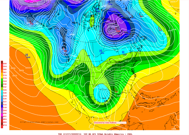
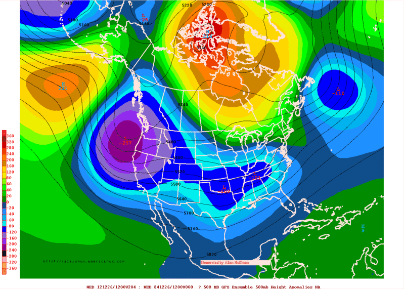
"Looking ahead to next week, today’s forecast models are painting a somewhat unsettled weather pattern for Texas and much of the nation. Another large trough of low pressure in the upper atmosphere is forecast to dip south out of the Rockies, moving across Texas Tuesday into Wednesday then exiting off to the northeast. While all of the details of this scenario are still somewhat uncertain, it appears a widespread area of light to moderate rain will develop across much of Texas beginning late Monday, continuing into Tuesday. Rain totals at this point are very uncertain but it’s possible we could see totals in the range of 0.5 to 1 inch. Dry and much colder weather looks to develop in the wave of this system the middle of next week. I’ll pass along more details on next week’s holiday weather picture in Tuesday’s report."
0 likes   
The preceding post is NOT an official forecast, and should not be used as such. It is only the opinion of the poster and may or may not be backed by sound meteorological data. It is NOT endorsed by any professional institution including storm2k.org. For Official Information please refer to the NHC and NWS products.

User avatar
Rgv20
S2K Supporter
S2K Supporter
Posts: 2466
Age: 39
Joined: Wed Jan 05, 2011 5:42 pm
Location: Edinburg/McAllen Tx

#976 Postby Rgv20 » Tue Dec 18, 2012 12:16 am

Thru 156hrs the 0zGFS Ensemble Means are nearly identical to the 0z Operational GFS and the 12z operational ECMWF at the 500mb Heights...
0 likes   
The following post is NOT an official forecast and should not be used as such. It is just the opinion of the poster and may or may not be backed by sound meteorological data. It is NOT endorsed by any professional institution including storm2k.org For Official Information please refer to the NHC and NWS products.

User avatar
TeamPlayersBlue
Category 5
Category 5
Posts: 3445
Joined: Tue Feb 02, 2010 1:44 am
Location: Denver/Applewood, CO

#977 Postby TeamPlayersBlue » Tue Dec 18, 2012 12:17 am

Ok now just a liitttttlllle further south for us :). I think we would get a little bit of stuff here but not much. Snow is never predicted till the near term for us anyway. Could we get a gulf low out of this maybe?
0 likes   
Personal Forecast Disclaimer:
The posts in this forum are NOT official forecast and should not be used as such. They are just the opinion of the poster and may or may not be backed by sound meteorological data. They are NOT endorsed by any professional institution or storm2k.org. For official information, please refer to the NHC and NWS products.

User avatar
Ntxw
Storm2k Moderator
Storm2k Moderator
Posts: 22786
Joined: Wed Oct 21, 2009 6:34 pm
Location: DFW, Texas

Re:

#978 Postby Ntxw » Tue Dec 18, 2012 12:18 am

TeamPlayersBlue wrote:Ok now just a liitttttlllle further south for us :). I think we would get a little bit of stuff here but not much. Snow is never predicted till the near term for us anyway. Could we get a gulf low out of this maybe?


Plenty of room for it. I think it will continue to in fact, nothing says it can't. The only problem too far south is access to cold air in time.
0 likes   
The above post and any post by Ntxw is NOT an official forecast and should not be used as such. It is just the opinion of the poster and may or may not be backed by sound meteorological data. It is NOT endorsed by any professional institution including Storm2k. For official information, please refer to NWS products.


  Help support Storm2K!

Help Support Storm2K


User avatar
Rgv20
S2K Supporter
S2K Supporter
Posts: 2466
Age: 39
Joined: Wed Jan 05, 2011 5:42 pm
Location: Edinburg/McAllen Tx

Re: Re:

#979 Postby Rgv20 » Tue Dec 18, 2012 12:32 am

Ntxw wrote:
TeamPlayersBlue wrote:Ok now just a liitttttlllle further south for us :). I think we would get a little bit of stuff here but not much. Snow is never predicted till the near term for us anyway. Could we get a gulf low out of this maybe?


Plenty of room for it. I think it will continue to in fact, nothing says it can't. The only problem too far south is access to cold air in time.


I think a track thru Central/South Texas is not out of the question by looking at the 0zGFS Ensemble Means 500mb Height Anomalies...Look at that Blocking!

Image
0 likes   
The following post is NOT an official forecast and should not be used as such. It is just the opinion of the poster and may or may not be backed by sound meteorological data. It is NOT endorsed by any professional institution including storm2k.org For Official Information please refer to the NHC and NWS products.

User avatar
TeamPlayersBlue
Category 5
Category 5
Posts: 3445
Joined: Tue Feb 02, 2010 1:44 am
Location: Denver/Applewood, CO

#980 Postby TeamPlayersBlue » Tue Dec 18, 2012 1:01 am

I would like to further my meteo knowledge tomorrow by researching what mechanics in the atmosphere play out so that you have massive blocking like this. The blocking they are predicting is very widespread across the arctic.
0 likes   
Personal Forecast Disclaimer:
The posts in this forum are NOT official forecast and should not be used as such. They are just the opinion of the poster and may or may not be backed by sound meteorological data. They are NOT endorsed by any professional institution or storm2k.org. For official information, please refer to the NHC and NWS products.


Return to “Winter Weather”

Who is online

Users browsing this forum: No registered users and 4 guests