A system will likely track fairly quickly east-northeastward from the Tennessee Valley off the Mid-Atlantic coast. It should pass south of Long Island before gradually turning more to the northeast. In my opinion, the NAM is too far to the north with the storm's likely track. A preponderance of the ensemble members are more in line with the GFS. Nevertheless, the air mass may well be marginal along coastal areas. Hence, even with what might typically be a favorable track, locations such as Newark, New York City, and extreme southern New England could experience a change to sleet and perhaps even rain for a time. Interior sections should do a little better in terms of snowfall amounts, but once one gets north of a line running from let's say Poughkeepsie to Hartford to Worcester, snowfall amounts will likely fall off given a lower qpf.
The bulk of the snow should fall on Friday, 2/22. A few areas could see the precipitation arrive late on Thursday. Along coastal New England, the last of the precipitation will likely depart early on Saturday.
In sum, while this storm may not be very impressive, it will at least provide a blanket of snow to parts of the East that have experienced all too little of it this winter. Although such cities as Ottawa and Burlington will likely be confined to the sidelines for this event, a storm could bring those cities a moderate to significant snowfall next week.
Initial Estimates:
Albany: 1"-3"
Allentown: 2"-4"
Baltimore: 1" or less
Boston: 3"-6"
Concord: 1"-3"
Harrisburg: 1"-3"
Hartford: 2"-4"
New York City: 2"-4"
Newark: 2"-4"
Philadelphia: 1"-3"
Providence: 3"-6"
Scranton: 3"-6"
Washington, DC:
...DCA: 1" or less
...IAD: 1" or less
Worcester: 2"-4"
2/21-23/2008 Snowstorm: Initial Estimates
Moderator: S2k Moderators
Forum rules
 The posts in this forum are NOT official forecast and should not be used as such. They are just the opinion of the poster and may or may not be backed by sound meteorological data. They are NOT endorsed by any professional institution or STORM2K.

The posts in this forum are NOT official forecast and should not be used as such. They are just the opinion of the poster and may or may not be backed by sound meteorological data. They are NOT endorsed by any professional institution or STORM2K.
-
donsutherland1
- S2K Analyst

- Posts: 2718
- Joined: Mon Sep 15, 2003 8:49 pm
- Location: New York
-
donsutherland1
- S2K Analyst
- Posts: 2718
- Joined: Mon Sep 15, 2003 8:49 pm
- Location: New York
Not much to change from yesterday after the latest batch of runs except for portions of New England. If anything, the warming aloft and at the surface for coastal areas might be a little more impressive than I had been thinking. In any case the following are my lastest snowfall estimates. Overall, the biggest snowfall accumulations are likely across northern Pennslvania across to portions of southern New England.
Initial Estimates:
Albany: 3"-6"
Allentown: 2"-4"
Baltimore: 1" or less
Boston: 4"-8"
Concord: 3"-6"
Harrisburg: 1"-3"
Hartford: 4"-8"
New York City: 2"-4"
Newark: 2"-4"
Philadelphia: 1"-3"
Pittsburgh: 3"-6"
Providence: 3"-6"
Scranton: 4"-8"
State College: 4"-8"
Washington, DC:
...DCA: 1" or less
...IAD: 1" or less
Worcester: 4"-8"
White Plains: 3"-6"
0 likes
-
ohiostorm

- Category 5

- Posts: 1582
- Age: 41
- Joined: Sat Oct 12, 2002 2:51 pm
- Location: Orlando, FL
- Contact:
Forecast for Pittsburgh looks acurate. Local mets saying 1 to 3 inches tonight with an additional 1 to 3 tomorrow depending on where you live. North of the city would have the better chances at more snow while south would see more mixing in of sleet and freezing rain then just plain rain. Lucky for me, I'm about 20 miles north of the city. Hopefully the ice stays away! Winter Weather Advisories have been posted from 7p tonight to 7p tomorrow for the entire Pittsburgh CWA.
0 likes
-
tomboudreau

- Category 5
- Posts: 1869
- Age: 49
- Joined: Tue Feb 18, 2003 6:07 pm
- Location: Carnegie, PA
- Contact:
-
donsutherland1
- S2K Analyst
- Posts: 2718
- Joined: Mon Sep 15, 2003 8:49 pm
- Location: New York
At this time, the guidance has moved into closer agreement. It does appear that the precipitation will be moving into the Mid-Atlantic and Northeast a little quicker than earlier modeled. As a result, a somewhat higher portion of the precipitation could fall in the frozen form. Nevertheless, coastal areas will likely go over to plain rain as warmer air moves in aloft.
Final Estimates:
Albany: 3"-6"
Allentown: 2"-4"
Baltimore: 1" or less
Boston: 4"-8"
Concord: 3"-6"
Harrisburg: 1"-3"
Hartford: 5"-10"
Islip: 1"-3"
New York City: 2"-4"
Newark: 2"-4"
Philadelphia: 1"-3"
Pittsburgh: 3"-6"
Portland: 3"-6"
Providence: 3"-6"
Scranton: 4"-8"
State College: 4"-8"
Washington, DC:
...DCA: 1" or less
...IAD: 1" or less
Worcester: 5"-10"
White Plains: 3"-6"
0 likes
-
Category 5

- Category 5
- Posts: 10074
- Age: 36
- Joined: Sun Feb 11, 2007 10:00 pm
- Location: New Brunswick, NJ
- Contact:
Re: 2/21-23/2008 Snowstorm: Initial Estimates
Still in the clear right now, but snow should be arriving soon.
0 likes
-
Category 5
- Category 5
- Posts: 10074
- Age: 36
- Joined: Sun Feb 11, 2007 10:00 pm
- Location: New Brunswick, NJ
- Contact:
Re: 2/21-23/2008 Snowstorm: Initial Estimates
Snowing steady now, already dustings on the sidewalks and streets.
0 likes
-
Category 5
- Category 5
- Posts: 10074
- Age: 36
- Joined: Sun Feb 11, 2007 10:00 pm
- Location: New Brunswick, NJ
- Contact:
-
tomboudreau
- Category 5
- Posts: 1869
- Age: 49
- Joined: Tue Feb 18, 2003 6:07 pm
- Location: Carnegie, PA
- Contact:
-
Category 5
- Category 5
- Posts: 10074
- Age: 36
- Joined: Sun Feb 11, 2007 10:00 pm
- Location: New Brunswick, NJ
- Contact:
Re: 2/21-23/2008 Snowstorm: Initial Estimates
Schools closed hahahaha.
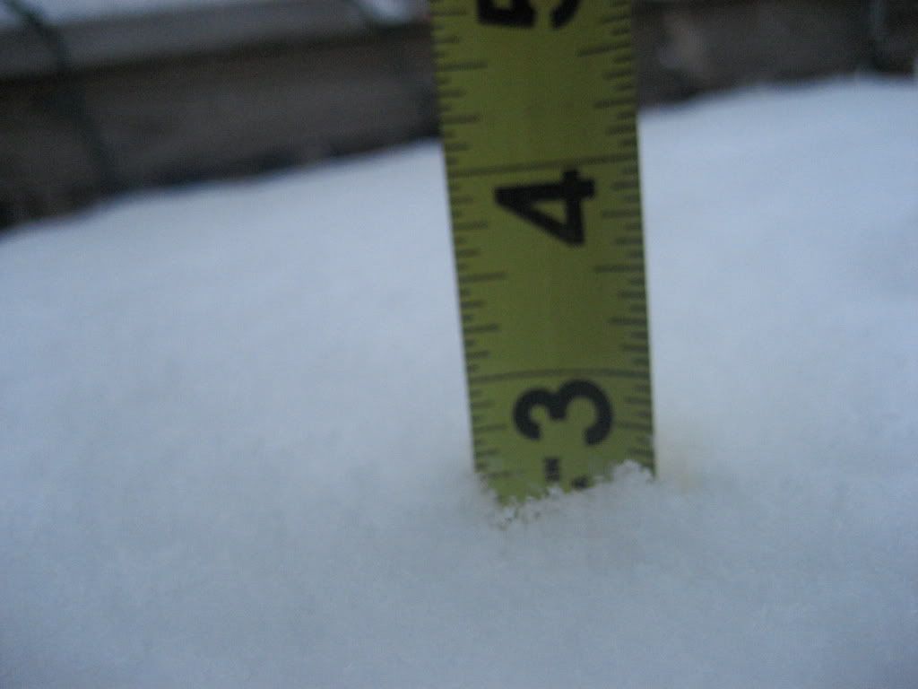
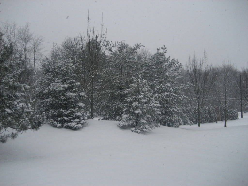
Still snowing, it's quite a pretty sight. Up to 2.5"
We're going to break the 3" barrier for the first time since the blizzard of 06.
Still snowing, it's quite a pretty sight. Up to 2.5"
We're going to break the 3" barrier for the first time since the blizzard of 06.
0 likes
-
Category 5
- Category 5
- Posts: 10074
- Age: 36
- Joined: Sun Feb 11, 2007 10:00 pm
- Location: New Brunswick, NJ
- Contact:
-
Category 5
- Category 5
- Posts: 10074
- Age: 36
- Joined: Sun Feb 11, 2007 10:00 pm
- Location: New Brunswick, NJ
- Contact:

-
Category 5
- Category 5
- Posts: 10074
- Age: 36
- Joined: Sun Feb 11, 2007 10:00 pm
- Location: New Brunswick, NJ
- Contact:
Re:
boca wrote:I used to live in Kendall Park, NJ.Hey Category 5 send some snow in dry ice to Florida for me I really miss it. Nice pics, I think you'll end up between 5 to 7" before the changeover.
I wish we'd get 5-7.
3.5" so far and it's starting to change toward sleet a bit. The winter weather advisory has been upgraded to a winter storm warning though.
0 likes
-
Squarethecircle
- Category 5
- Posts: 2165
- Joined: Fri Oct 19, 2007 4:00 pm
- Location: Fairfax, VA
-
Coredesat
-
Stephanie

- S2K Supporter

- Posts: 23843
- Age: 63
- Joined: Thu Feb 06, 2003 9:53 am
- Location: Glassboro, NJ
Re: 2/21-23/2008 Snowstorm: Initial Estimates
We had about 2 - 3 inches of snow by the time I left for work at 7:30 this morning. By the time I was half way there, the snow was mixing with sleet and it was still below freezing. When I arrived in Atlantic City, it had turned to rain with sleet and it was about 34 degrees. I was REALLY WORRIED about the drive home tonight but fortunately it wasn't really an issue.
For a while there, the NWS had upgraded us to a Winter Storm Warning from an Advisory, calling for perhaps over 5 inches of snow and ice.
It seems like the storm never had a chance to really "blow up" over the Atlantic. That's kind of what don was saying in his forecast originally.
For a while there, the NWS had upgraded us to a Winter Storm Warning from an Advisory, calling for perhaps over 5 inches of snow and ice.
It seems like the storm never had a chance to really "blow up" over the Atlantic. That's kind of what don was saying in his forecast originally.
0 likes
-
weathermom

- Category 2

- Posts: 760
- Joined: Tue Aug 31, 2004 7:59 pm
- Location: North Jersey
Re: 2/21-23/2008 Snowstorm: Initial Estimates
We got about 7" before it changed to a very light misty rain. Perfect for turning it into winter break snowman/snowball snow for the kids. Also perfect because it didn't come Weds nite or Thursday when we were coming back from DC!
0 likes
-
angelwing

- S2K Supporter
- Posts: 4462
- Age: 64
- Joined: Tue Jan 18, 2005 3:06 pm
- Location: Kulpsville, PA
Re: 2/21-23/2008 Snowstorm: Initial Estimates
I didn't go to work in the AM, looked out the window at 5:30AM and saw about 4 inches n the top of my van so forget it, not driving 45 miles to work. By the time I went to my night job it was pretty good, it was raining, but the roads weren't icy.
0 likes
-
donsutherland1
- S2K Analyst
- Posts: 2718
- Joined: Mon Sep 15, 2003 8:49 pm
- Location: New York
Verification:
From: 2/20/2008 1:45 pm:
Albany: 1"-3"; Actual: 3.4"; Error: 0.4"
Allentown: 2"-4"; Actual: 4.5"; Error: 0.5"
Baltimore: 1" or less; Actual: 0.6"; Within range
Boston: 3"-6"; Actual: 8.9"; Error: 2.9"
Concord: 1"-3"; Actual: 4.4"; Error: 1.4"
Harrisburg: 1"-3"; Actual: 1.8"; Within range
Hartford: 2"-4"; Actual: 7.8"; Error: 3.8"
New York City: 2"-4"; Actual: 6.0"; Error: 2.0"
Newark: 2"-4"; Actual: 6.8"; Error: 2.8"
Philadelphia: 1"-3"; Actual: 3.2"; Error: 0.2"
Providence: 3"-6"; Actual: 3.2"; Within range
Scranton: 3"-6"; Actual: 5.4"; Within range
Washington, DC:
...DCA: 1" or less; Actual: Trace; Within range
...IAD: 1" or less; Actual: Trace; Within range
Worcester: 2"-4"; Actual: 9.1"; Error: 5.1"
From: 2/21/2008 1:34 pm:
Albany: 3"-6"; Actual: 3.4"; Within range
Allentown: 2"-4"; Actual: 4.5"; Error: 0.5"
Baltimore: 1" or less; Actual: 0.6"; Within range
Boston: 4"-8"; Actual: 8.9"; Error: 0.9"
Concord: 3"-6"; Actual: 4.4"; Within range
Harrisburg: 1"-3"; Actual: 1.8"; Within range
Hartford: 4"-8"; Actual: 7.8"; Within range
New York City: 2"-4"; Actual: 6.0"; Error: 2.0"
Newark: 2"-4"; Actual: 6.8"; Error: 2.8"
Philadelphia: 1"-3"; Actual: 3.2"; Error: 0.2"
Pittsburgh: 3"-6"; Actual: 2.1"; Error: 0.9"
Providence: 3"-6"; Actual: 3.2"; Within range
Scranton: 4"-8"; Actual: 5.4"; Within range
State College: 4"-8"; Actual: 5.3" (Williamsport); Within range
Washington, DC:
...DCA: 1" or less; Actual: Trace; Within range
...IAD: 1" or less; Actual: Trace; Within range
Worcester: 4"-8"; Actual: 9.1"; Error: 1.1"
White Plains: 3"-6"; Actual: 8.0"; Error: 2.0"
From 2/21/2008 10:37 pm:
Albany: 3"-6"; Actual: 3.4"; Within range
Allentown: 2"-4"; Actual: 4.5"; Error: 0.5"
Baltimore: 1" or less; Actual: 0.6"; Within range
Boston: 4"-8"; Actual: 8.9"; Error: 0.9"
Concord: 3"-6"; Actual: 4.4"; Within range
Harrisburg: 1"-3"; Actual: 1.8"; Within range
Hartford: 5"-10"; Actual: 7.8"; Within range
Islip: 1"-3"; Actual: 5.5"; Error: 2.5"
New York City: 2"-4"; Actual: 6.0"; Error: 2.0"
Newark: 2"-4"; Actual: 6.8"; Error: 2.8"
Philadelphia: 1"-3"; Actual: 3.2"; Error: 0.2"
Pittsburgh: 3"-6"; Actual: 2.1"; Error: 0.9"
Portland: 3"-6"; Actual: 5.1"; Within range
Providence: 3"-6"; Actual: 3.2"; Within range
Scranton: 4"-8"; Actual: 5.4"; Within range
State College: 4"-8"; Actual: 5.3" (Williamsport); Within range
Washington, DC:
...DCA: 1" or less; Actual: Trace; Within range
...IAD: 1" or less; Actual: Trace; Within range
Worcester: 5"-10"; Actual: 9.1"; Within range
White Plains: 3"-6"; Actual: 8.0"; Error: 2.0"
0 likes
Who is online
Users browsing this forum: No registered users and 31 guests