12z Wed ECMWF has Major Storm

Winter Weather Discussion

Moderator: S2k Moderators

Forum rules

The posts in this forum are NOT official forecast and should not be used as such. They are just the opinion of the poster and may or may not be backed by sound meteorological data. They are NOT endorsed by any professional institution or STORM2K.

Help Support Storm2K
Message
Author
Anonymous

12z Wed ECMWF has Major Storm

#1 Postby Anonymous » Wed Feb 18, 2004 6:29 pm

Today's run of the European has a HELL of a storm Day 7... however, it's not clear to my eyes whether or not there will be sufficient cold air when it hits the East Coast. The low is already tracking fairly far north (through SE MO / NW MS) at this point, so if this is going to be wintry east of the mountains it had better redevelop with a cold high moving in. The obvious -NAO signature should help us out in that category. What is clear is that a 540dm upper-level low over Mississippi is something that bears watching ;)!

500mb Day 7:

Image

Surface Day 7:

Image
0 likes   

molecules
Tropical Low
Tropical Low
Posts: 47
Joined: Tue Feb 17, 2004 5:57 pm
Location: Wilmington, DE

#2 Postby molecules » Wed Feb 18, 2004 6:35 pm

Colder air will be a problem for most given the Low being around 980
0 likes   

Anonymous

#3 Postby Anonymous » Wed Feb 18, 2004 6:41 pm

molecules wrote:Colder air will be a problem for most given the Low being around 980

I guess we'll have to wait to see the "real" graphics to confirm this, but I'd tend to agree given the surface map depicted by tonight's run... the only saving grace would be strong cold air damming setting up as the storm approaches. But my view on this is that the simple fact that the EC has a very intense upper-level low in the southern U.S. should be sending an alert that a major event is possible somewhere in the eastern part of the country... who knows whether or not the surface details are accurate on any individual run. Let's see what the other models and future runs of the Euro have to say about it over the next few days.
0 likes   

User avatar
Stormsfury
Category 5
Category 5
Posts: 10549
Age: 53
Joined: Wed Feb 05, 2003 6:27 pm
Location: Summerville, SC

#4 Postby Stormsfury » Wed Feb 18, 2004 6:41 pm

Until the Plymouth Maps come out, but IF there's NO CAD signature, this COULD imply (based on those crappy graphics), the first major severe weather outbreak of the season ...
0 likes   

User avatar
Erica
Professional-Met
Professional-Met
Posts: 168
Joined: Sat Feb 14, 2004 2:45 am
Location: Daytona Beach, FL
Contact:

#5 Postby Erica » Wed Feb 18, 2004 6:45 pm

hmmm, this bares quite a bit of watching, and infact both the GFS 12z and 18z runs had the system as well, but suppressed. I dont't theink the concern is the amount of cold air in place, it's moreso whether or not it can come up the coast.

The GFS 18z run was quite a hit for the lower mid Atlantic, say from Washington DC south. North of Philadelphia, there isn't much to speak of.

Image

Image

Image

The 12z run was further north, so I wouldin't worry. theres plenty of time for the track to shift north and the Philadelphia to Boston Corridor to be affected.

Generally most Major east coast snowstorms (which effect the whole I-95 corridor) occur on Weekends, where as lower Mid Atlantic Major winter storms take place during the middle of the week (wednesday/Thursday). This would be a Wednesday and Thursday event.
0 likes   

User avatar
Erica
Professional-Met
Professional-Met
Posts: 168
Joined: Sat Feb 14, 2004 2:45 am
Location: Daytona Beach, FL
Contact:

#6 Postby Erica » Wed Feb 18, 2004 6:51 pm

Stormsfury wrote:Until the Plymouth Maps come out, but IF there's NO CAD signature, this COULD imply (based on those crappy graphics), the first major severe weather outbreak of the season ...


The Wright-weather graphics are alot better than the Plymouth ones. By the way, the GFS did have some Cold air damming signature onthe 18z run with the high to the northwest making it possible.

http://web.wright-weather.com/ecmwf-nh.shtml
0 likes   

molecules
Tropical Low
Tropical Low
Posts: 47
Joined: Tue Feb 17, 2004 5:57 pm
Location: Wilmington, DE

#7 Postby molecules » Wed Feb 18, 2004 6:54 pm

brettjrob wrote:
molecules wrote:Colder air will be a problem for most given the Low being around 980

I guess we'll have to wait to see the "real" graphics to confirm this, but I'd tend to agree given the surface map depicted by tonight's run... the only saving grace would be strong cold air damming setting up as the storm approaches. But my view on this is that the simple fact that the EC has a very intense upper-level low in the southern U.S. should be sending an alert that a major event is possible somewhere in the eastern part of the country... who knows whether or not the surface details are accurate on any individual run. Let's see what the other models and future runs of the Euro have to say about it over the next few days.


Very Very true 2 early to tell the accuarcy on the surface maps at this time.
This is something to watch sn or rn at this time especially along the east coast. "beaches"
0 likes   

Anonymous

#8 Postby Anonymous » Wed Feb 18, 2004 6:59 pm

Erica wrote:The Wright-weather graphics are alot better than the Plymouth ones.

I agree... it's a shame they don't update as the data rolls in like the PSC does though.
0 likes   

User avatar
Stormsfury
Category 5
Category 5
Posts: 10549
Age: 53
Joined: Wed Feb 05, 2003 6:27 pm
Location: Summerville, SC

#9 Postby Stormsfury » Wed Feb 18, 2004 7:00 pm

Erica wrote:
Stormsfury wrote:Until the Plymouth Maps come out, but IF there's NO CAD signature, this COULD imply (based on those crappy graphics), the first major severe weather outbreak of the season ...


The Wright-weather graphics are alot better than the Plymouth ones. By the way, the GFS did have some Cold air damming signature onthe 18z run with the high to the northwest making it possible.

http://web.wright-weather.com/ecmwf-nh.shtml

Yeah, I just looped the GFS maps and saw the configuration hints ... AND also, the GFS shows a secondary developing off the Carolina coasts ... basically now it's a wait and see when the Plymouth/WW maps are updated ...

We're heading into the volatile months in regards to severe weather and potential extreme late winter weather events and the GFS/ECMWF are definitely hinting at the possibilities ...

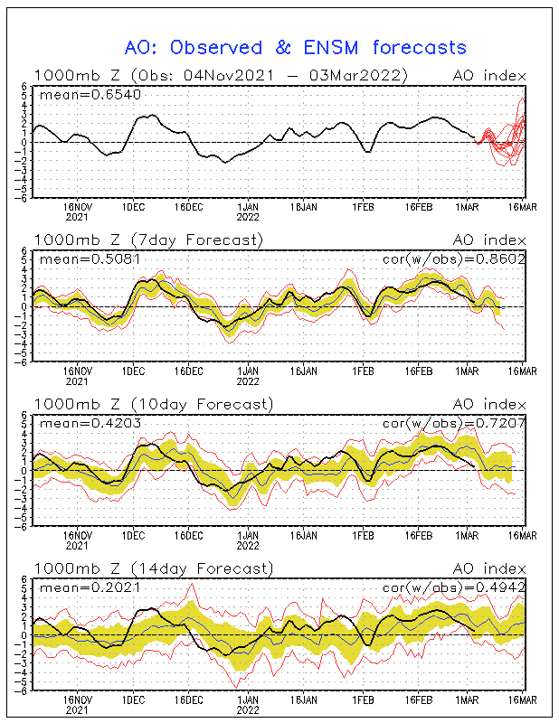
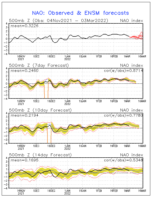
Forecast ENS mean ... NAO tanks NEG at the time of the progged developing storm ...
Image

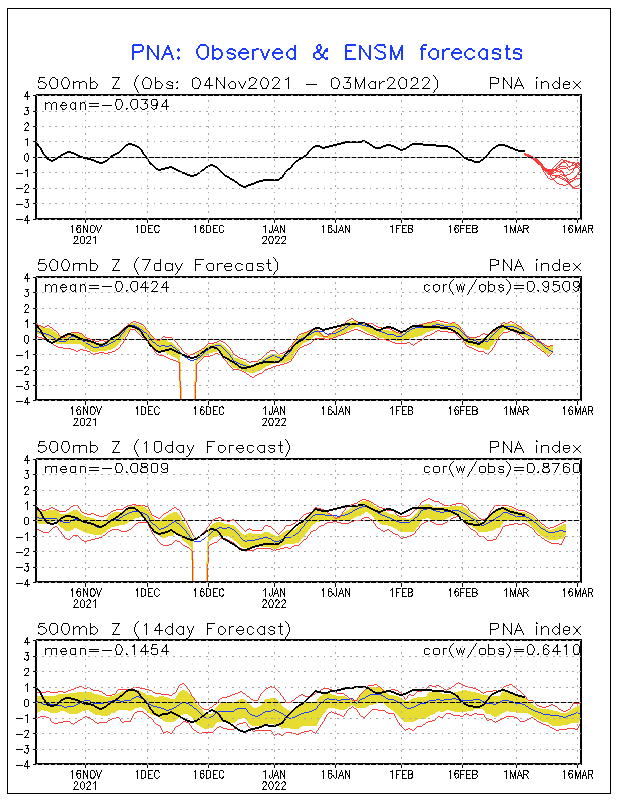
Forecasted PNA ENS mean ... generally a mod PNA pattern indication ...

Image

General consensus of a NEG AO ...

Image

IF cold air damming becomes a factor and we begin to see continued strong hints, obviously, the potential for a major storm looms .... based on what I've seen today, a Miller B scenario does look quite possible, UNLESS ... the SFC low/500mb feature raises heights and brings a substantial amount of WAA. (and more likely a Miller A scenario)

There's gonna be a fight over teleconnections ... Strong NF Low vs. SE ridge ... which argue against each other ... gonna be yet another forecasting nightmare ahead in the cards ...

SF
0 likes   

User avatar
Erica
Professional-Met
Professional-Met
Posts: 168
Joined: Sat Feb 14, 2004 2:45 am
Location: Daytona Beach, FL
Contact:

#10 Postby Erica » Wed Feb 18, 2004 7:19 pm

Stormsfury wrote:
Erica wrote:
Stormsfury wrote:Until the Plymouth Maps come out, but IF there's NO CAD signature, this COULD imply (based on those crappy graphics), the first major severe weather outbreak of the season ...


The Wright-weather graphics are alot better than the Plymouth ones. By the way, the GFS did have some Cold air damming signature onthe 18z run with the high to the northwest making it possible.

http://web.wright-weather.com/ecmwf-nh.shtml

Yeah, I just looped the GFS maps and saw the configuration hints ... AND also, the GFS shows a secondary developing off the Carolina coasts ... basically now it's a wait and see when the Plymouth/WW maps are updated ...

We're heading into the volatile months in regards to severe weather and potential extreme late winter weather events and the GFS/ECMWF are definitely hinting at the possibilities ...

Forecast ENS mean ... NAO tanks NEG at the time of the progged developing storm ...
Image

Forecasted PNA ENS mean ... generally a mod PNA pattern indication ...

Image

General consensus of a NEG AO ...

Image

IF cold air damming becomes a factor and we begin to see continued strong hints, obviously, the potential for a major storm looms .... based on what I've seen today, a Miller B scenario does look quite possible, UNLESS ... the SFC low/500mb feature raises heights and brings a substantial amount of WAA. (and more likely a Miller A scenario)

There's gonna be a fight over teleconnections ... Strong NF Low vs. SE ridge ... which argue against each other ... gonna be yet another forecasting nightmare ahead in the cards ...

SF


If it is Southeast Ridge vs. The blocking and 50/50 low, then the system will have a better chance of effecting the I-95 corridor more significantly.
0 likes   

User avatar
Colin
Category 5
Category 5
Posts: 5086
Joined: Fri Apr 18, 2003 4:17 pm
Location: Catasauqua, PA
Contact:

#11 Postby Colin » Wed Feb 18, 2004 9:04 pm

Well, it's over already. It being on Wed/Thurs...another supressed system most likely. I give up.
0 likes   

molecules
Tropical Low
Tropical Low
Posts: 47
Joined: Tue Feb 17, 2004 5:57 pm
Location: Wilmington, DE

#12 Postby molecules » Wed Feb 18, 2004 9:16 pm

colin.....you seem a little ( - ) no offense, but I do agree this will not be a coastal storm. Another southern runner swimming w/ the fishes and to warm for NC/VA area

March 2004 is the call for this year more favorable conditions
0 likes   

wharrell
Tropical Low
Tropical Low
Posts: 15
Joined: Sun Sep 07, 2003 3:46 pm
Location: Cary, North Carolina
Contact:

Yawn.....

#13 Postby wharrell » Wed Feb 18, 2004 9:33 pm

Another fantasy storm
0 likes   

Cheesy_Poofs
Category 1
Category 1
Posts: 376
Joined: Wed Nov 19, 2003 5:54 pm
Contact:

#14 Postby Cheesy_Poofs » Wed Feb 18, 2004 9:37 pm

Colin wrote:Well, it's over already. It being on Wed/Thurs...another supressed system most likely. I give up.


Your giving up on a storm SEVEN days away?
Last edited by Cheesy_Poofs on Wed Feb 18, 2004 9:48 pm, edited 1 time in total.
0 likes   

User avatar
SacrydDreamz
Category 1
Category 1
Posts: 311
Joined: Thu Aug 28, 2003 9:00 pm
Location: Durham, NC
Contact:

#15 Postby SacrydDreamz » Wed Feb 18, 2004 9:42 pm

12z GGEM has a great CAD signature with massive overrunning. I don't believe cold air will generally be a problem north of the NC/VA line. If NC is to get in on the action (4"+) I think we'd better see some CAD as is shown on the GGEM. GFS looks decent at this range with regard to CAD signature.. it tends to strenghten over time. We shall see, definitely bears watching. Best chance of a 12"+ snow in VA this year IMO.
0 likes   

Anonymous

#16 Postby Anonymous » Thu Feb 19, 2004 1:04 am

Erica wrote:Generally most Major east coast snowstorms (which effect the whole I-95 corridor) occur on Weekends, where as lower Mid Atlantic Major winter storms take place during the middle of the week (wednesday/Thursday). This would be a Wednesday and Thursday event.


are you serious? You have got to be kidding lol. You think storms know what day of the week it is? LMAO--its all coincidence...

the storm says"We cant go up the coast because its thursday....Had it been saturday..then we would of turned up"
0 likes   

User avatar
JQ Public
Category 5
Category 5
Posts: 4488
Joined: Thu Feb 06, 2003 1:17 am
Location: Cary, NC

#17 Postby JQ Public » Thu Feb 19, 2004 2:15 am

Erica wrote:Generally most Major east coast snowstorms (which effect the whole I-95 corridor) occur on Weekends, where as lower Mid Atlantic Major winter storms take place during the middle of the week (wednesday/Thursday). This would be a Wednesday and Thursday event.


Is there a scientific reason for this or smthg that usually happens and can't be explained?
0 likes   

Anonymous

#18 Postby Anonymous » Thu Feb 19, 2004 6:49 am

JQ Public wrote:
Erica wrote:Generally most Major east coast snowstorms (which effect the whole I-95 corridor) occur on Weekends, where as lower Mid Atlantic Major winter storms take place during the middle of the week (wednesday/Thursday). This would be a Wednesday and Thursday event.


Is there a scientific reason for this or smthg that usually happens and can't be explained?

A few weeks ago DT posted on this topic on WWBB:

There has been RECENT RESEARCH that has been cited here many times as well as by JB and by Joe D'Aleo that shows over the past 20+ years MORE rain and snow DOES fall over the Northeast US over weekends.

The reason ? air pollution during the week builds up so that IF some sort of cold front or Low is developing *** IF*** then the water vapor has more suspended particuli to work with.

The problem is that you are so filled with hate towrds me that it never occurred to you I might be right.


Other than that, I'm not sure there's a meteorological explanation, but if you look at all the major snowstorms for the I-95 corridor over the past few decades, it's startling how few of them were not in the Friday-Monday period.
0 likes   

Superstorm
Tropical Low
Tropical Low
Posts: 41
Joined: Thu Jul 10, 2003 1:04 pm

#19 Postby Superstorm » Thu Feb 19, 2004 8:44 am

Brett, you think this storm has a good chance of bringing snow to our area?
0 likes   

User avatar
yoda
Category 5
Category 5
Posts: 7874
Joined: Tue Jan 13, 2004 3:51 pm
Location: Springfield VA (20 mins south of DC)
Contact:

#20 Postby yoda » Thu Feb 19, 2004 9:17 am

We will have to watch the trends very closely..... hoping for a goos storm here in D.C.

Also, since temps here in D.C will be in 50s for the next few days.... won't be harder for colder temps to re-establish themselves here in the Mid-Atlantic? :roll:
0 likes   


Return to “Winter Weather”

Who is online

Users browsing this forum: No registered users and 7 guests