The Evolution Toward Winter 2004-05

Winter Weather Discussion

Moderator: S2k Moderators

Forum rules

The posts in this forum are NOT official forecast and should not be used as such. They are just the opinion of the poster and may or may not be backed by sound meteorological data. They are NOT endorsed by any professional institution or STORM2K.

Help Support Storm2K
Message
Author
donsutherland1
S2K Analyst
S2K Analyst
Posts: 2718
Joined: Mon Sep 15, 2003 8:49 pm
Location: New York

The Evolution Toward Winter 2004-05

#1 Postby donsutherland1 » Wed Nov 17, 2004 8:13 pm

Over the past few weeks, there have been a number of developments that tend to shed further light on the upcoming winter. At this point in time, although the PDO might differ what from my earlier assumptions as outlined in my preliminary ideas, my overall conclusion remains unchanged:

Given the preponderance of possible analogs coming up, I believe Winter 2004-05 will see colder than normal conditions in the eastern third to half of the United States and warmer than normal ones in the western quarter to third of the United States. Just to be clear, on a regional scale, I do not believe that cold anomalies will rival those of the extreme Winter of 1976-77. Rather, the figures will probably come out somewhere between those of Winters 2002-03 and 2003-04—probably somewhat warmer than Winter 2002-03 but somewhat colder than Winter 2003-04—particularly in the Washington, DC to Boston region.

The following are a few of the big developments:

Northern Hemisphere/North American Snowcover: The trend continues to be impressive. If such snowcover reaches 34 million or more square kilometers by the end of November--something I expect--the idea of much above snowfall could extend farther south to let's say New York City and Philadelphia.

QBO Reversal: The QBO has briefly moved back to somewhat more positive territory. Consequently, the idea of a postive QBO until at least February or March looks more likely. Earlier, I had anticipated a January-February switch (roughly a compromise between the possibilities were it to have continued to decline or were it to have at least one reversal). ENSO-West (or close to zero) conditions per DT's research could lead to fun possibilities, especially during the February-March period.

PDO Goes Negative: For the first time in 27 months, the PDO dropped below zero in October. I had assumed a positive PDO for the winter. However, the overall idea does not change much in this case. Some of the less attractive possibilities fall by the wayside due to a significantly different QBO situation.

Right now, the PDO seems to be resembling 1958's PDO:

Code: Select all

PDO      
Month   1958   2004
May   1.28   0.88
June   1.33   0.04
July   0.89   0.44
Aug   1.06   0.85
Sept   0.29   0.75
Oct   0.01   -0.11


I am not using 1958-59 for a possible analog because its QBO was strongly negative (averaged < -17 for the December-March period). I am using the 1958-59 situation for guidance. This suggests that it is possible that Winter 2004-05 might see the PDO fluctuate between + and -.

Also, in my view, the closest negative PDO analog to 2004-05, assuming it has a negative PDO for the winter, is probably 1963-64: ENSO, QBO, MEI, NAO are all consistent with what I am anticipating.

NAO: At this point in time, I am increasingly confident that the NAO will average below 0 for the December-February and December-March periods. I'll have a final idea once I see the November data.

ENSO Region 1+2: An Ugly Wrinkle?
In recent weeks, Region 1+2's cool anomaly has disappeared and at last word, its anomaly was moving into weak El Niño territory:

Code: Select all

Region 1+2          
Week      Temp.   Anom.
1-Sep-04   20.1   -0.5
8-Sep-04   19.8   -0.7
15-Sep-04   19.8   -0.7
22-Sep-04   20.4   -0.2
29-Sep-04   20.5   -0.2
6-Oct-04   20.8   0.0
13-Oct-04   20.5   -0.4
20-Oct-04   21.4   0.3
27-Oct-04   21.3   0.1
3-Nov-04   21.5   0.2
10-Nov-04   22.0   0.5


Whether or not the ENSO criteria is sustained for a basin-wide ENSO to become official remains to be seen. However, given a wider look at the Pacific, I tend to doubt that this criteria will be maintained as the normal water temperatures continue rise. If I'm correct, as November ends and December begins, the warm anomalies here should begin to shrink.
0 likes   

User avatar
Chris the Weather Man
Category 2
Category 2
Posts: 746
Joined: Fri Dec 12, 2003 9:49 pm
Location: NJ

#2 Postby Chris the Weather Man » Wed Nov 17, 2004 9:16 pm

Don, Last year was COLD in Jan, and DT is saying A VERY COLD Feb, as cold as 1989 , well on his maps it says. If I remember correctly, Jan 2003 was cold, Feb 2003 was Colder, March was cold, but I think this year, in Feb could might rival the cold of Jan of 2004........ We Shall See..... In terms of snow, I think we can see 1 big snowstorm...
0 likes   

User avatar
CaptinCrunch
S2K Supporter
S2K Supporter
Posts: 8728
Age: 57
Joined: Mon Nov 03, 2003 4:33 pm
Location: Kennedale, TX (Tarrant Co.)

#3 Postby CaptinCrunch » Thu Nov 18, 2004 9:42 am

PROGNOSTIC DISCUSSION FOR MONTHLY OUTLOOK
NWS CLIMATE PREDICTION CENTER CAMP SPRINGS MD
830 PM EST THU NOV 18 2004

30-DAY OUTLOOK DISCUSSION FOR DECEMBER 2004
.
SST ANOMALIES IN THE CENTRAL EQUATORIAL PACIFIC ARE ABOUT 0.8 C ABOVE NORMAL
AND EXPECTED TO CONTINUE INTO DECEMBER. THIS AMOUNTS TO A VERY WEAK WARM EVENT.

WE USED LAST MONTH'S NDJ SEASONAL FORECAST AS FIRST GUESS AND CONSULTED
THE CFS, VARIOUS FORMS OF OCN, VARIOUS FORMS OF CCA, TREND ADJUSTED ENSO
COMPOSITES AND THE CAS.

THE TEMPERATURE OUTLOOK FOR DECEMBER SHOWS ABOVE AVERAGE TEMPERATURES IN THE
WESTERN ONE THIRD OF THE LOWER 48 AND INTO SE ALASKA. THIS WARMTH IS INDICATED
BY MANY TOOLS. IN MINNESOTA AND SURROUNDING AREAS ENSO COMPOSITES AND THE CFS
AGREED ON BELOW NORMAL TEMPERATURES. ELSEWHERE EC IS PREDICTED BECAUSE OF EITHER
CONTRADICTIONS AMONG TOOLS OR ONLY A SINGLE TOOL PRODUCING A SIGNAL.

MANY TOOLS INDICATE ABOVE-MEDIAN PRECIPITATION IN TEXAS AND AJACENT
AREAS. AN ENSO RELATED BELOW MEDIAN PRECIPITATION AREA IS SHOWN IN OHIO AND
WESTERN PA. ELSEWHERE THERE ARE NO RELIABLE INDICATIONS FOR PRECIPITATION.
0 likes   

donsutherland1
S2K Analyst
S2K Analyst
Posts: 2718
Joined: Mon Sep 15, 2003 8:49 pm
Location: New York

#4 Postby donsutherland1 » Thu Nov 18, 2004 10:49 am

Chris,

Things are looking very good for February 2005. There seems to be broad-based consensus (DT, HM, etc.)--and I'm in agreement with that consensus--that February could be very exciting in terms of cold and snowfall.

A number of analog years had at least one big East Coast snowstorm. Even if the PDO remains negative, with 1963-64 probably being the best fit in that situation, one should note that January 1964 saw a blizzard affect the Eastern U.S.
0 likes   

donsutherland1
S2K Analyst
S2K Analyst
Posts: 2718
Joined: Mon Sep 15, 2003 8:49 pm
Location: New York

#5 Postby donsutherland1 » Thu Nov 18, 2004 10:51 am

CaptinCrunch,

With Region 1+2 having developed warm anomalies, a more active subtropical jet appears likely for at least the first part of the winter. Consequently, the idea that December might prove wet in Texas and nearby areas is a good one.
0 likes   

aggiecutter
Category 5
Category 5
Posts: 1753
Joined: Thu Oct 14, 2004 9:22 pm
Location: Texarkana

#6 Postby aggiecutter » Thu Nov 18, 2004 12:48 pm

Western ridge without an overwhelming signal in the Pacific means below normal temperatures for the plains all the way to the GOM for december. The only thing that may save the east and southeast in december is the cold water off the East Coast, which promotes ridging.
0 likes   

FreeSkier
Tropical Wave
Tropical Wave
Posts: 4
Joined: Thu Nov 04, 2004 3:44 am

#7 Postby FreeSkier » Fri Nov 19, 2004 4:58 am

New models look Better!
0 likes   

User avatar
KWT
Category 5
Category 5
Posts: 31415
Joined: Tue Aug 17, 2004 11:02 am
Location: UK!!!

#8 Postby KWT » Fri Nov 19, 2004 7:52 pm

well all the signs are that we in the U.K may have a signifacant cold spell,lasting a week on the 28th November(note that date is likely to change over th next few days).Although it is still to early to tell the signs are good,we have a strong block,the atlntic is queit and the greenland high reaches 1040 as well.

last night we had the first fall,the largest total was around 3 inches,so not much but considering it weren't forecast,its pretty impressive.

and the block is keeping Scandinavia under cold temps as well,and with the jet stream weak and to our south,things are looking good for us,I'm got to try not to get carried away though!!
0 likes   
Personal Forecast Disclaimer:
The posts in this forum are NOT official forecast and should not be used as such. They are just the opinion of the poster and may or may not be backed by sound meteorological data. They are NOT endorsed by any professional institution or storm2k.org. For official information, please refer to the NHC and NWS products

User avatar
wxguy25
Professional-Met
Professional-Met
Posts: 708
Joined: Wed Oct 13, 2004 4:44 pm
Location: East Central Florida
Contact:

Re: The Evolution Toward Winter 2004-05

#9 Postby wxguy25 » Sat Nov 20, 2004 2:19 pm

donsutherland1 wrote:Over the past few weeks, there have been a number of developments that tend to shed further light on the upcoming winter. At this point in time, although the PDO might differ what from my earlier assumptions as outlined in my preliminary ideas, my overall conclusion remains unchanged:

Given the preponderance of possible analogs coming up, I believe Winter 2004-05 will see colder than normal conditions in the eastern third to half of the United States and warmer than normal ones in the western quarter to third of the United States. Just to be clear, on a regional scale, I do not believe that cold anomalies will rival those of the extreme Winter of 1976-77. Rather, the figures will probably come out somewhere between those of Winters 2002-03 and 2003-04—probably somewhat warmer than Winter 2002-03 but somewhat colder than Winter 2003-04—particularly in the Washington, DC to Boston region.

The following are a few of the big developments:

Northern Hemisphere/North American Snowcover: The trend continues to be impressive. If such snowcover reaches 34 million or more square kilometers by the end of November--something I expect--the idea of much above snowfall could extend farther south to let's say New York City and Philadelphia.

QBO Reversal: The QBO has briefly moved back to somewhat more positive territory. Consequently, the idea of a postive QBO until at least February or March looks more likely. Earlier, I had anticipated a January-February switch (roughly a compromise between the possibilities were it to have continued to decline or were it to have at least one reversal). ENSO-West (or close to zero) conditions per DT's research could lead to fun possibilities, especially during the February-March period.

PDO Goes Negative: For the first time in 27 months, the PDO dropped below zero in October. I had assumed a positive PDO for the winter. However, the overall idea does not change much in this case. Some of the less attractive possibilities fall by the wayside due to a significantly different QBO situation.

Right now, the PDO seems to be resembling 1958's PDO:

Code: Select all

PDO      
Month   1958   2004
May   1.28   0.88
June   1.33   0.04
July   0.89   0.44
Aug   1.06   0.85
Sept   0.29   0.75
Oct   0.01   -0.11


I am not using 1958-59 for a possible analog because its QBO was strongly negative (averaged < -17 for the December-March period). I am using the 1958-59 situation for guidance. This suggests that it is possible that Winter 2004-05 might see the PDO fluctuate between + and -.

Also, in my view, the closest negative PDO analog to 2004-05, assuming it has a negative PDO for the winter, is probably 1963-64: ENSO, QBO, MEI, NAO are all consistent with what I am anticipating.

NAO: At this point in time, I am increasingly confident that the NAO will average below 0 for the December-February and December-March periods. I'll have a final idea once I see the November data.

ENSO Region 1+2: An Ugly Wrinkle?
In recent weeks, Region 1+2's cool anomaly has disappeared and at last word, its anomaly was moving into weak El Niño territory:

Code: Select all

Region 1+2          
Week      Temp.   Anom.
1-Sep-04   20.1   -0.5
8-Sep-04   19.8   -0.7
15-Sep-04   19.8   -0.7
22-Sep-04   20.4   -0.2
29-Sep-04   20.5   -0.2
6-Oct-04   20.8   0.0
13-Oct-04   20.5   -0.4
20-Oct-04   21.4   0.3
27-Oct-04   21.3   0.1
3-Nov-04   21.5   0.2
10-Nov-04   22.0   0.5


Whether or not the ENSO criteria is sustained for a basin-wide ENSO to become official remains to be seen. However, given a wider look at the Pacific, I tend to doubt that this criteria will be maintained as the normal water temperatures continue rise. If I'm correct, as November ends and December begins, the warm anomalies here should begin to shrink.


Don, great discussion, as always.

For "official" El Nino conditions to exist, the 3.4 region must average at or above +0.5 C for three months or more. The 1+2 region is more important to La Nina events.

Assuming that 1963-64 serves as our BEST analog right now, the current El Nino should peak In DEC, decline in JAN and FEB and completely dissipated by MAR.

1963 10 21.00 0.09 25.55 0.67 29.05 0.65 27.59 0.99
1963 11 21.92 0.24 25.76 0.80 28.70 0.34 27.45 0.94
1963 12 22.83 -0.01 26.05 0.97 28.48 0.20 27.58 1.11
1964 1 24.17 -0.32 26.01 0.40 28.67 0.53 27.42 0.91
1964 2 24.98 -1.06 26.34 -0.02 28.21 0.20 27.14 0.45
1964 3 25.04 -1.44 26.66 -0.43 27.70 -0.40 26.96 -0.18
0 likes   

donsutherland1
S2K Analyst
S2K Analyst
Posts: 2718
Joined: Mon Sep 15, 2003 8:49 pm
Location: New York

Re: The Evolution Toward Winter 2004-05

#10 Postby donsutherland1 » Tue Nov 23, 2004 11:49 pm

Great points, wxguy25.

After another week of data, Region 3.4 continues to hold relatively stable in terms of its anomalies (+0.8°C). So far things continue to point to the weak ENSO event that will likely fade as you described.
0 likes   

User avatar
KWT
Category 5
Category 5
Posts: 31415
Joined: Tue Aug 17, 2004 11:02 am
Location: UK!!!

#11 Postby KWT » Sun Nov 28, 2004 4:07 pm

well looks like that potenial cold didn't happen,although many places got snow on the 18th due to a cold front sweeping south introducing much colder temps.

what is very intresting is that ECMWF is going for a easterly wind that is orginating from seibria which is very very cold at the moment:

http://www.ecmwf.int/products/forecasts ... 4112812!!/


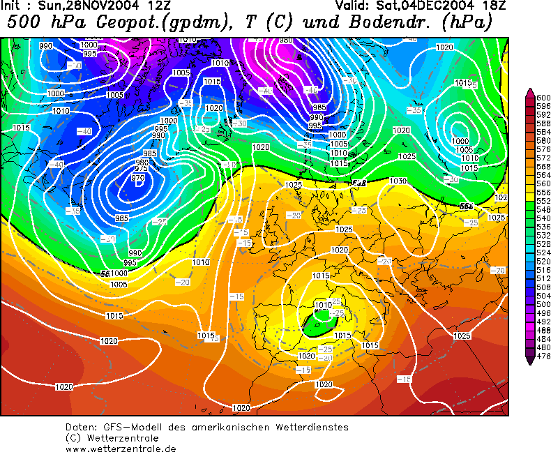
Infact whats more intresting here is the frightening remsemblacne between 4th December according to GFS:

Image


and also from the 4th December 1962...the year of the coldest winter in 250 years here in the U.K:

Image
0 likes   

User avatar
Wnghs2007
Category 5
Category 5
Posts: 6836
Age: 36
Joined: Wed Mar 24, 2004 11:14 pm
Location: Gwinnett-Barrow Line; Georgia
Contact:

#12 Postby Wnghs2007 » Sun Nov 28, 2004 5:38 pm

Thats sounds really interesting KWT!!!!! :)
0 likes   

User avatar
KWT
Category 5
Category 5
Posts: 31415
Joined: Tue Aug 17, 2004 11:02 am
Location: UK!!!

#13 Postby KWT » Mon Nov 29, 2004 2:39 pm

well sadly the models are not looking nearly as good tonight,both the UKMO and GFS both want to give us some form of zonality as they push the high eastwards,due to a strongish northerly jet,although saying that ECMWF still makes things at least slightly intresting with the high sticking around while giving us some cool weather...
0 likes   
Personal Forecast Disclaimer:
The posts in this forum are NOT official forecast and should not be used as such. They are just the opinion of the poster and may or may not be backed by sound meteorological data. They are NOT endorsed by any professional institution or storm2k.org. For official information, please refer to the NHC and NWS products

User avatar
Wnghs2007
Category 5
Category 5
Posts: 6836
Age: 36
Joined: Wed Mar 24, 2004 11:14 pm
Location: Gwinnett-Barrow Line; Georgia
Contact:

#14 Postby Wnghs2007 » Mon Nov 29, 2004 2:42 pm

KWT wrote:well sadly the models are not looking nearly as good tonight,both the UKMO and GFS both want to give us some form of zonality as they push the high eastwards,due to a strongish northerly jet,although saying that ECMWF still makes things at least slightly intresting with the high sticking around while giving us some cool weather...


Yes the bad thing about yall gettting cold is the correlation between a Mid West to Central European Trough Correlates to a Positive NAO and strong SE Ridge. So in a sense the higher the weaker the trough over that reigon of Europe the better for the EUS.
0 likes   

User avatar
KWT
Category 5
Category 5
Posts: 31415
Joined: Tue Aug 17, 2004 11:02 am
Location: UK!!!

#15 Postby KWT » Tue Nov 30, 2004 11:38 am

in some ways though it can still all change yet,as we are only just entering December.

Afterall you only have to look back to 1947:

December was very mild indeed thanks to a Bartlett high,however during late December it actually rideged northwards and the rest was history,needless to say we haven't had a snowy winter since.

still I live in hope.
0 likes   
Personal Forecast Disclaimer:
The posts in this forum are NOT official forecast and should not be used as such. They are just the opinion of the poster and may or may not be backed by sound meteorological data. They are NOT endorsed by any professional institution or storm2k.org. For official information, please refer to the NHC and NWS products

User avatar
Wnghs2007
Category 5
Category 5
Posts: 6836
Age: 36
Joined: Wed Mar 24, 2004 11:14 pm
Location: Gwinnett-Barrow Line; Georgia
Contact:

#16 Postby Wnghs2007 » Tue Nov 30, 2004 2:56 pm

KWT wrote:in some ways though it can still all change yet,as we are only just entering December.

Afterall you only have to look back to 1947:

December was very mild indeed thanks to a Bartlett high,however during late December it actually rideged northwards and the rest was history,needless to say we haven't had a snowy winter since.

still I live in hope.


Well hopefully you will see some snow. Just enough. Hopefully by mid jan thought the NAO will go extremely Negative and by by Southeast US ridge. And the PNA go Boom. LOL
0 likes   

User avatar
KWT
Category 5
Category 5
Posts: 31415
Joined: Tue Aug 17, 2004 11:02 am
Location: UK!!!

#17 Postby KWT » Sat Dec 04, 2004 4:24 am

....well yeah that would be nice!!!!

well the synoptics are very intresting at the moment,and full of it's and buts.

we are currently heading towards a mild spell,temps are going to get upto 12C and this looks like going for a little while,however at the same time we have a Euro high that is heading northwards,towards Scandinavia,although the jet is to strong to cause a real true scandinavia high,its still should be enough to suck in a South-easterly flow which is cool,although could get cold at times,the best model to see the high moving is the UKMO:

http://129.13.102.67/wz/pics/Rukm1441.gif

while GFS goes for a rather unsettled feel.what could be very intresting on the UKMO chart is if the high can 'link' upto the Seibrian high thats poking into the top right of the chart,which if that happens(like I suspect it may...)then the block would be very hard to move indeed,and eventually come around christmas time may even start to suck in Easterlies...so still all to play for in the U.K.
0 likes   
Personal Forecast Disclaimer:
The posts in this forum are NOT official forecast and should not be used as such. They are just the opinion of the poster and may or may not be backed by sound meteorological data. They are NOT endorsed by any professional institution or storm2k.org. For official information, please refer to the NHC and NWS products


Return to “Winter Weather”

Who is online

Users browsing this forum: No registered users and 7 guests