 The posts in this forum are NOT official forecast and should not be used as such. They are just the opinion of the poster and may or may not be backed by sound meteorological data. They are NOT endorsed by any professional institution or

The long-heralded colder, snowier pattern is now well underway in the eastern United States. Through at least the first 1-2 weeks of March, readings are likely to remain mainly below normal in the East with above normal snowfall.
Key points from last week’s pattern discussion:
• For now, in the East, the February 20-27 period should be colder than the February 13-19 timeframe (Mid-Atlantic and New England). A storm will likely bring some accumulations of snow from Philadelphia to Boston later Sunday into Monday. The storm could end as some rain especially the farther south one goes. This will not be a big storm and it should be a quick-mover given that the blocking regime is just now beginning to evolve. It likely will not become the proverbial “50/50” low.
Temperature anomalies for 2/13-19:
Boston: +0.9°
New York City: +1.1°
Washington, DC: +1.3°
Temperature anomalies for 2/20-25:
Boston: -3.3°
New York City: -2.1°
Washington, DC: -0.6°
Per the latest guidance, the cooler anomalies should increase over the next two days.
The 2/20-21 period saw 5.0” snow fall at NYC. This storm did not become a 50-50 low.
• [A]nother system that will likely move off the lower Mid-Atlantic Coast Thursday into Friday will probably bring some light snow or flurries to parts of the northern Mid-Atlantic and even perhaps southern New England. In its wake should be another cold air mass. This cold air mass will likely be similar to the one now moving into the East for the weekend but has some potential to be several degrees colder.
The 2/24-25 storm saw accumulating snow from DCA to BOS: 2.9” at DCA, 6.0” at NYC and 8.0” (through 2/25 4 am) at Boston. A renewed shot of cool air followed, but it was not as cold as the aforementioned air mass.
• [/I]The Southeast will probably not see noticeable cold during the February 20-27 period. However, in the wake of a storm that should bring a cool rain to such cities as Atlanta and Raleigh, colder air should move in for the end of the week.[/I]
Temperatures averaged above to much above normal in Atlanta through February 23. February 21-23 each saw a high temperature of 72°. Afterward, cooler air arrived.
• The first part of the coming week should see moderation in Chicago and Detroit. However, a colder air mass should push into the region by Wednesday or Thursday (February 23-24) and it could bring some accumulations of snow to such cities as Detroit and Cleveland.
Milder air prevailed during the February 19-22 period with a cooldown commencing on February 22 at Chicago and February 23 at Detroit. Chicago saw 1.1” of snow (1.0” on the 20th) and Detroit received 6.3” (5.6” on the 20th).
• The weekend looks to be balmy in the Central Plains. However, a system moving across the region could bring some rain, ice, or even snow to parts of the area by midweek next week. Behind the storm, readings should be trending downward. Another shot of even colder air is likely the following week.
The February 19-20 period saw temperatures run much above normal in the Central Plains states. Kansas City was 15° above normal on February 20 and Omaha was 9° above normal. Afterward cooling occurred but it was not severe. Omaha received a trace of snow on February 21 and 24. Kansas City received no snow.
• Seattle’s prospects are for gradually building warmth after a briefly shot of cooler air brings seasonal to somewhat below normal readings to the Pacific Northwest for Sunday and Monday. Readings should be rising to above normal levels late in the week and should average above normal the following week.
The February 20-22 period was cool in Seattle. The low temperature fell to 28° on February 21. Milder air followed. The high temperature reached 61° on February 24 and 25.
• In California, the rains should continue to soak the region from time to time. An important storm could bring rain to Los Angeles Sunday or Monday. Another storm could arrive late in the week.
Heavy rains continued to flood the greater Los Angeles area. In the February 20-22 period, Downtown Los Angeles saw 5.06” rain. For the 5-day February 18-22 period, Downtown Los Angeles was soaked by 8.10” rainfall.
The February 27-March 12 Ideas:
An extraordinary blocking pattern is now in place. On February 25 the NAO fell to –5.955, the 16th lowest value on record (out of 20,145 observations since daily recordkeeping began). This also made the February 2005 blocking pattern the 7th strongest on record. The February 2005 blocking pattern is the first since February 1978 to record two or more consecutive days where the NAO averaged –5.500 or below.
This extreme situation will provide the basis for the overall pattern. Given the rare nature of the pattern, I do not expect the models to perform as well as they normally perform. For background information on how extreme blocks tend to resolve during situations where the SOI is negative, one can read my earlier post on such patterns. That post provides useful background information for sorting through the model uncertainties.
In addition, if one examines the mean 500 mb height anomalies at the peak of extreme blocks and negative SOI situations, one finds that anomalously low 500 mb heights are located off the New England coast in patterns where Kocin-Uccellini-type snowstorms failed to materialize following the height of such blocking. Where such storms occurred, those below normal height anomalies are located well to the north and east of the New England waters. At the same time, the favorable setups for the Kocin-Uccellini-type snowstorms see a trough in the general vicinity of the Gulf of Alaska. Such a trough has been absent from the less favorable setups. The February 2005 block more closely fits the Kocin-Uccellini-type situation, as might be expected during weak El Niño winters:
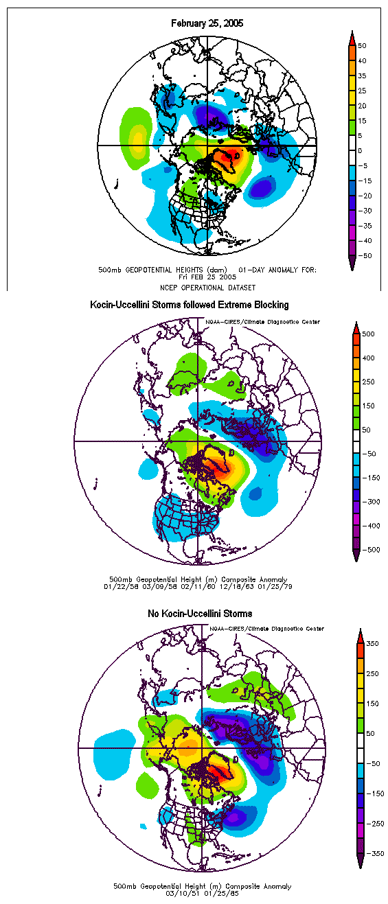
Bear in mind, this is actual data and not modeled heights. Consequently, this situation also leads me to conclude that the ECMWF depiction is probably the more likely scenario than the inland GFS track (2/25 12z runs).
Taking into consideration this pattern and relying heavily on the ECMWF Model and its ensembles, I believe parts of the northern Mid-Atlantic to the Northeastern United States will see a significant snowfall during February 28-March 2 period. Along the immediate coastline there may be changeover issues for a time. Nevertheless, the big cities from Washington, DC to Boston should receive accumulating snow.
• Per the synoptic experience with extreme blocks and the ECMWF/ECMWF ensembles, I expect a powerful storm to pass just the New Jersey coast toward Cape Cod. There should be stronger high pressure over Quebec than is currently shown on some of the modeling. Right now, details remain sketchy but I believe odds of seeing the following snowfall even with changeover issues are as follows:
Boston: 4” or more: High; 6” or more: Moderate
New York City: 4” or more: High; 6” or more: Moderate
Philadelphia: 4” or more: High; 6” or more: Moderate
Washington, DC: 4” or more: Moderate; 6” or more: Low
The potential does exist for more snowfall in some or all of these cities, but that would be covered in a separate thread as the details become clearer and if it is merited. In the wake of the February 28-March 2 event, look for colder air to surge into this region. Low temperatures could well fall into the upper teens and lower 20s before moderation takes place after midweek.
An energetic clipper could bring additional light snow or flurries to parts of this region, especially from Philadelphia northward during the March 3-4 period. After March 7, per the GFS ensembles, there is a signal for possibly another major storm.
Throughout the period, look for temperatures to average below to much below normal.
• The February 27-March 7 period should prove quite snowy across the Midwest and Ohio Valley. However, the best snow from the major February 28-March 2 storm may fall just to the east of this region. Look for the entire period covered by this pattern discussion to see below normal temperatures.
• February 27 could see some rain in the Central Plains states. Through March 5, the Central Plains states should see readings average generally above normal with the greatest warmth likely during the March 2-4 period. The March 6-12 period should see somewhat cooler readings and there could be a shot of cold air that brings readings below normal.
• California will likely see a new storm arrive with some rain during the February 28-March 1 timeframe. Rainfall should not be as copious as recent rains. The overall period covered by the pattern discussion should remain wetter than normal. March 5 could see temperatures become noticeably warmer in California. The following week, likely after March 7, renewed rains could arrive.
• Dry and relatively warm weather should continue in Seattle through the period covered by this pattern discussion. March 4-10 will likely see readings running above to perhaps much above normal.
SOI, Extreme Block Point to Cold March in the East:
Since 1895 when the CPC's reanalysis data is available, the SOI has gone down (monthly averages) by 8 or more points 15 times. In 8 years, March then saw the SOI average positive. In 7, it averaged negative.
Here's what happened in the East:
• March: Positive SOI
Northeast: Normal to above normal temperatures: 5/8 years
Mid-Atlantic: Normal to above normal: 6/8 years
Southeast: Normal to above normal: 6/8 years
• March: Negative SOI
Northeast: Below normal to normal temperatures: 5/7 years
Mid-Atlantic: Below normal to normal temperatures: 5/7 years
Southeast: Below normal to normal temperatures: 5/7 years
In 4 of the 5 (80%) seasons in which extreme blocks (where the NAO fell to –5.500 or below) peaked February 15 or later but before March 10, the eastern half of the United States saw normal to below temperatures for the month of March. The cold anomalies were especially pronounced in the central United States:

The mildest readings in the East were typically confined to eastern New England. This situation results because, on average, such blocks have had a tendency to retrograde (travel from east to west) during the course of their existence.
For additional information on the current extreme blocking situation: http://www.storm2k.org/phpbb2/viewtopic.php?t=58287
March Snowfall Likely from Washington, DC to Boston:
In addition from the information cited above with regard to the pattern currently in place and the discussion as to what lies ahead through March 12, it should be noted that the ENSO analogs strongly support the idea of accumulating snow from Washington, DC to Boston in March.
• Top 15 ENSO Matches:
Boston: Average Snowfall: 8.1”; 10/22 (45%) years with 6” or more
New York City: Average Snowfall: 3.5”
Washington, DC: Average Snowfall: 2.2”
• Top 15 ENSO Matches and NAO:
Boston: Average Snowfall: 8.5”; 4/11 (36%) years with 6” or more
New York City: Average Snowfall: 4.0”; 5/11 (45%) years with 6” or more
Washington, DC: Average Snowfall: 3.2”; 4/11 (36%) years with 4” or more
• Top 15 ENSO Matches and QBO:
Boston: Average Snowfall: 8.6”; 6/9 (67%) years with 6” or more
New York City: Average Snowfall: 4.6”; 4/9 (44%) years with 6” or more
Washington, DC: Average Snowfall: 2.8”; 3/9 (33%) years with 4” or more
• Top 15 ENSO Matches and PDO:
Boston: Average Snowfall: 10.8”; 7/13 (54%) years with 6” or more
New York City: Average Snowfall: 4.4”; 5/13 (38%) years with 6” or more
Washington, DC: Average Snowfall: 2.7”; 5/11 (38%) years with 4” or more
Given the pattern likely to predominate the first half of March, I believe it is reasonable to expect that Boston will likely see 8” or more in March, NYC should see 6” or more, and Washington, DC 3” or more.


