On February 23, in the post concerning extreme blocks, I noted: Considering that February 2005 is all but certain to see the SOI average -10.00 or below and Winter 2004-05 was a weak El Niño winter (not a La Niña one), should the NAO drop to -5.500 or below in coming days, the probability of a Kocin-Uccellini snowstorm at some point as the extreme blocking episode begins to weaken could be high.
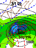
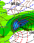
Per that study of extreme blocks and consistent guidance from the ECMWF/ECMWF ensembles/GFS ensembles, I believed that an offshore/coastal track was more likely than something punching inland, much less west of the Appalachians. Now, as we move into the eve of the event, and the strong model consensus that has more or less held firm, I have confidence that Winter 2004-05 is going to witness its second "Kocin-Uccellini" snowstorm of the season. This will likely also be a widespread event that could register a high 3 or even low 4 on the NESIS scale.
To be sure, I had envisioned an accumulating snow-changing to rain-ending as snow scenario for the big cities but had not expected that the amounts of snow would be as substantial as now appear likely. Larry Cosgrove had seen the full snowy potential for days out end, so his medium-range outlook is noted for its excellence.
At 18z, the NAM continued its slow but steady march toward the GFS and the offshore/coastal model consensus. Earlier, I had been wary of the NAM even as I gave it far less weight than the other models on this event. With its continuing eastward trend, my concern is much reduced.
As of now, my initial estimates for total snowfall (even considering changeover issues in some of the areas) are as follows:
Armonk: 12"-18"
Babylon: 6"-12"
Baltimore: 6"-12"
Boston: 6"-12"
Morristown: 12"-20"
New York City: 8"-16"
Newark: 8"-16"
Philadelphia: 7"-14"
Poughkeepsie: 8"-14"
Providence: 6"-10"
Richmond: 2"-5"
Trenton: 8"-16"
Washington, DC: 5"-10"
White Plains: 10"-18"
Winchester: 4"-8"
2/28-3/1/2005 Storm: Initial Estimates
Moderator: S2k Moderators
Forum rules
 The posts in this forum are NOT official forecast and should not be used as such. They are just the opinion of the poster and may or may not be backed by sound meteorological data. They are NOT endorsed by any professional institution or STORM2K.

The posts in this forum are NOT official forecast and should not be used as such. They are just the opinion of the poster and may or may not be backed by sound meteorological data. They are NOT endorsed by any professional institution or STORM2K.
-
donsutherland1
- S2K Analyst

- Posts: 2718
- Joined: Mon Sep 15, 2003 8:49 pm
- Location: New York


-
donsutherland1
- S2K Analyst
- Posts: 2718
- Joined: Mon Sep 15, 2003 8:49 pm
- Location: New York
-
donsutherland1
- S2K Analyst
- Posts: 2718
- Joined: Mon Sep 15, 2003 8:49 pm
- Location: New York
-
donsutherland1
- S2K Analyst
- Posts: 2718
- Joined: Mon Sep 15, 2003 8:49 pm
- Location: New York
Yea, nothing has changed with respect to the GFS. I see no westward shift from one run to the next. Seems like everything remains on track. If GFS solution is correct, 6-12" in Baltimore would verify and even locally heavier amounts are possible in heavier mesoscale banding features. Will see. The exact track is key.
Jim
Jim
0 likes
-
donsutherland1
- S2K Analyst
- Posts: 2718
- Joined: Mon Sep 15, 2003 8:49 pm
- Location: New York
-
al79philly
- Tropical Storm

- Posts: 113
- Joined: Tue Aug 31, 2004 3:19 pm
Don thanks for turning me on to the NESIS scale... I had never heard of it before this. Anyone who loves the snow should read this paper - http://www.weatheranswer.com/public/NES ... s%20scale' - it is very interesting.
0 likes
-
Planetsnow
- Tropical Depression

- Posts: 97
- Joined: Wed Jan 12, 2005 12:56 pm

-
donsutherland1
- S2K Analyst
- Posts: 2718
- Joined: Mon Sep 15, 2003 8:49 pm
- Location: New York
-
donsutherland1
- S2K Analyst
- Posts: 2718
- Joined: Mon Sep 15, 2003 8:49 pm
- Location: New York
-
donsutherland1
- S2K Analyst
- Posts: 2718
- Joined: Mon Sep 15, 2003 8:49 pm
- Location: New York
-
donsutherland1
- S2K Analyst
- Posts: 2718
- Joined: Mon Sep 15, 2003 8:49 pm
- Location: New York
Re: 2/28-3/1/2005 Storm: Initial Estimates
The tragedy of a massive bust: February 28-March 1, 2005 Storm:
Armonk: 12"-18"; Actual: 7.1"
Babylon: 6"-12"; Actual: 6.8" (Islip)
Baltimore: 6"-12"; Actual: 3.2"
Boston: 6"-12"; Actual: 8.1"
Morristown: 12"-20"; Actual: 9.5"
New York City: 8"-16"; Actual: 7.7"
Newark: 8"-16"; Actual: 9.4"
Philadelphia: 7"-14"; Actual: 5.6"
Poughkeepsie: 8"-14"; Actual: 6.4"
Providence: 6"-10"; Actual: 6.8"
Richmond: 2"-5"; Actual: 0.3"
Trenton: 8"-16"; Actual: 6.3"
Washington, DC: 5"-10"; Actual: 2.2"
White Plains: 10"-18"; Actual: 7.1"
Winchester: 4"-8"; Actual: 5.0"
10/15 were busts.
0 likes
Who is online
Users browsing this forum: No registered users and 202 guests