2/8 12z GFS: Probably Too Extreme

Winter Weather Discussion

Moderator: S2k Moderators

Forum rules

The posts in this forum are NOT official forecast and should not be used as such. They are just the opinion of the poster and may or may not be backed by sound meteorological data. They are NOT endorsed by any professional institution or STORM2K.

Help Support Storm2K
Message
Author
donsutherland1
S2K Analyst
S2K Analyst
Posts: 2718
Joined: Mon Sep 15, 2003 8:49 pm
Location: New York

2/8 12z GFS: Probably Too Extreme

#1 Postby donsutherland1 » Wed Feb 08, 2006 11:52 am

The GFS is suddenly showing a fairly impressive snowstorm for parts of the East Coast. But in my view, it is probably too extreme.

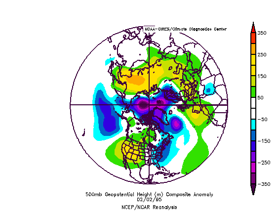
Currently, the NAO is -0.237 and is forecast to remain in a relatively narrow range for at least several days. A look at past February Kocin-Uccellini snowstorms that followed a modestly negative NAO reveals only a single case that has somewhat similar 500 mb setup to the timeframe in which the GFS is showing a possible significant event: February 2-4, 1995:

Image

Forecast NCEP ensemble mean 500 mb height anomalies (96 hours):
Image

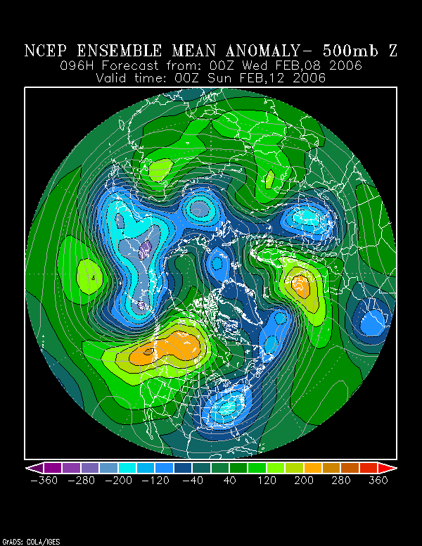
But if one looks more closely, aside from some modest placement differences with respect to the ridge-trough setup, one finds the forecast trough for this weekend to be noticeably broader than that for the 1995 storm.

What this means is that, should the ensemble mean be right--and it is well-supported by many of the individual members--the storm will likely take a track farther offshore than what the 2/8 12z operational GFS is suggesting. Hence, no blockbuster East Coast snowstorm.

However, it should also be noted that the ensemble members have been slowly trending westward. I don't believe this trend can be ignored.

Therefore, at this point in time, I believe that part of the East Coast could be brushed/clipped by snowfall and perhaps with some accumulations. It would not surprise me if some modest accumulations (perhaps a maximum of a few inches but probably less?) would occur in some of the big cities.

However, eastern New England would probably be the beneficiary of most of the snow and have the highest chance of possibly picking up 4" or more (moderate probability? Maybe a low to moderate probability for Montauk Point?). A lot of uncertainty still remains, but that's my thinking at this time.

In any case, some snow is better than none. Of course, I could bust badly, so time will tell.
0 likes   

Steve H.
Category 5
Category 5
Posts: 2146
Joined: Sat Oct 19, 2002 9:06 am
Location: Palm Bay, Florida

#2 Postby Steve H. » Wed Feb 08, 2006 1:00 pm

Don, I agree that this could be too extreme, but the tide is beginning to shift somewhat westward. I suspect the GFS will drift a hair east on the next run, then shift further to the west after that. NOGAPS/UKMET at 12z show a position further west as well. I think it a bit premature to say a brushing to the New England coast, but based on the current model output.....yes, you are correct. I look forward to the next couple of EC runs to see if there is any change there. At least there is something of significant interst on the map. 12z also shows freezing temps down here in central Florida! That is mainly driven by the extreme deep low the model shows that is driving the cold air down. Don't want to cover the plants :roll: Wait a minute, all my plants are gone from the hurricanes :eek:
0 likes   

sphinx
Tropical Depression
Tropical Depression
Posts: 51
Joined: Fri Feb 20, 2004 8:26 pm

#3 Postby sphinx » Wed Feb 08, 2006 3:17 pm

With respect to this upcoming "model-storm", it's interesting to compare the preliminary and final forecast discussions. Big change.

I've looked at several different model solutions at several different times. The operational 12Z GFS solution and the 12Z NAM solution couldn't be more different. Are NAM ensembles run or is a coarser resolution NAM nonsensical ?

Several model solutions have the storm brushing the coast while a few have it well out at sea. Then there's the GFS!

Clearly, we await more guidance.
0 likes   

Brent
S2K Supporter
S2K Supporter
Posts: 38090
Age: 36
Joined: Sun May 16, 2004 10:30 pm
Location: Tulsa Oklahoma
Contact:

#4 Postby Brent » Wed Feb 08, 2006 3:53 pm

HPC is really biting:

EW 12Z/08 GFS/UKMET/ECMWF RUNS ARE SUPPORTING AN INCREASING
THREAT OF A MAJOR WINTER WEATHER EVENT FOR THE APPALACHIANS AND
THE I-95 CORRIDOR BY SAT DAY 3. THE CORRESPONDING NAM AND CANADIAN
MODEL RUNS ARE FLATTER/MORE SUPPRESSED WITH THIS SYS. HOWEVER THE
STRONG LONGWAVE RIDGE ALL 12Z MODELS SHOW FOR 12Z/11 ALONG 120W
SUPPORTS THE IDEA OF CORRESPONDING STRONG HEIGHT FALLS IN THE
DOWNSTREAM LONGWAVE TROF OVER THE ERN CONUS. SUCH HEIGHT
FALLS...IN TURN...SUPPORT SIGNIFICANT CYCLOGENESIS ALONG THE SE
COASTAL STATES SAT...THEN DEEPENING UP THE ATLANTIC COAST.
0 likes   
#neversummer

Dave C
S2K Supporter
S2K Supporter
Posts: 868
Joined: Thu Sep 04, 2003 4:36 pm
Location: Middleboro, Mass.(midway between Cape Cod and Boston)

#5 Postby Dave C » Wed Feb 08, 2006 4:46 pm

The latest discussion from NWS they seem to think the weaker storm models aren't sharpening the east coast trough enough as the Pacific system dives towards the Gulf of Mexico . As you guys are saying, watch the trend!. At least we have something interesting to watch over the coming days :wink:
0 likes   

User avatar
Hybridstorm_November2001
S2K Supporter
S2K Supporter
Posts: 2811
Joined: Sat Aug 21, 2004 2:50 pm
Location: SW New Brunswick, Canada
Contact:

#6 Postby Hybridstorm_November2001 » Wed Feb 08, 2006 4:55 pm

This is why I love the weather so more, 'cause ya just never know for sure.


Should be interesting to see how this storm (which up until fairly recently all the models showed as next to nothing) evolves.
0 likes   

User avatar
Hybridstorm_November2001
S2K Supporter
S2K Supporter
Posts: 2811
Joined: Sat Aug 21, 2004 2:50 pm
Location: SW New Brunswick, Canada
Contact:

#7 Postby Hybridstorm_November2001 » Wed Feb 08, 2006 5:33 pm

Here is the latest from my area up North:


LONG TERM (SATURDAY NIGHT THROUGH WEDNESDAY)...
HIGH PRESSURE CRESTING OVER THE STATE SATURDAY NIGHT WILL BRING A
CLEAR AND COLD NIGHT SATURDAY NIGHT WITH TEMPERATURES BELOW ZERO
OVER MUCH OF THE NORTH AND SINGLE DIGITS SOUTH. OUR ATTENTION WILL
THEN TURN TO A POTENTIALLY SIGNIFICANT EAST COAST STORM DEVELOPING
OFF THE MID ATLANTIC COAST SATURDAY NIGHT. THE LOW DEVELOPS
FRIDAY AS A POWERFUL SHORTWAVE DIGGING DOWN FROM CANADA LOCKS INTO
A SMALL SOUTHERN BRANCH WAVE MOVING INTO THE GULF COAST AREA. THE
PHASED LOW DEVELOPS ALONG THE SOUTHEAST COAST SATURDAY MORNING AND
INTENSIFIES AS IT MOVES UP THE EAST COAST DURING THE DAY SATURDAY.
THE GFS IS MOST AGGRESSIVE WITH THIS SYSTEM DEVELOPING A MAJOR
EAST COAST SNOWSTORM THAT WOULD BLANKET THE NATION FROM THE
SOUTHERN APPALACHIANS NORTH THROUGH THE MAJOR CITIES AND ON UP
ACROSS ALL OF MAINE.
THE UKMET SEEMS TO BE AGREEING WITH THE GFS.
THE NEW ECMWF IS A BIT MORE OPEN WITH THE UPPER LEVEL SHORTWAVE
BUT STILL SHOWS THE STORM COMING FAR ENOUGH NORTH TO AT LEAST
AFFECT DOWNEAST AREAS AND POSSIBLY EASTERN PORTIONS OF THE NORTH.
THE LEAST ENTHUSIASTIC OF THE MODELS ARE THE ETA AND GEM WHICH
ONLY PRODUCE A WEAK WAVE THAT SLIPS OUT TO SEA WITHOUT GETTING A
CHANCE TO DIG AND INTENSIFY. WITH THE GOOD TRACK RECORD OF THE GFS
THIS WINTER...WE ARE ENTHUSIASTIC ABOUT THE POTENTIAL FOR AN
EVENT...WHICH WOULD BE LATE SUNDAY INTO SUNDAY NIGHT. FOR NOW JUST
GOING CHC POPS. WITH DEEP COLD AIR IN PLACE THIS WOULD LIKELY BE
AN ALL SNOW EVENT THROUGHOUT THE AREA IF IT DOES MATERIALIZE.
AFTER THE WEEKEND THE WEATHER IS GENERALLY COLD AND DRY INTO MID
WEEK WITH ONLY FLURRIES FROM TIME TO TIME EXPECTED.


Source: http://www.nws.noaa.gov/data/CAR/AFDCAR
0 likes   

User avatar
WindRunner
Category 5
Category 5
Posts: 5806
Age: 34
Joined: Fri Jul 29, 2005 8:07 pm
Location: Warrenton, VA, but Albany, NY for school
Contact:

#8 Postby WindRunner » Wed Feb 08, 2006 6:42 pm

The GFS even got a mention by our local TV met (Doug Hill on ABC7). And if that happens around here, then it's definately something to watch.
0 likes   

donsutherland1
S2K Analyst
S2K Analyst
Posts: 2718
Joined: Mon Sep 15, 2003 8:49 pm
Location: New York

#9 Postby donsutherland1 » Wed Feb 08, 2006 6:42 pm

12z ensembles and 18z Operational GFS continued to strongly support the storm. The probability of a more serious storm could be increasing, but later runs will help clarify the situation.
0 likes   

Jim Hughes
Category 3
Category 3
Posts: 825
Joined: Sun Jul 24, 2005 1:52 pm
Location: Martinsburg West Virginia

#10 Postby Jim Hughes » Wed Feb 08, 2006 8:16 pm

donsutherland1 wrote:12z ensembles and 18z Operational GFS continued to strongly support the storm. The probability of a more serious storm could be increasing, but later runs will help clarify the situation.


I'd have to give these model runs serious creditability. This is why I like forecasting way out in advance. So that you can have more confidence as things develop.

I just screwed up on the timing of this wave. The extreme amplitude is there but it's coming a couple of days early. Oh well......live and learn.
Maybe a clipper could give us some during my time frame. That's really not going to be the same though. I wanted to nail the timing of this storm.


Jim
0 likes   

donsutherland1
S2K Analyst
S2K Analyst
Posts: 2718
Joined: Mon Sep 15, 2003 8:49 pm
Location: New York

Re: 2/8 12z GFS: Probably Too Extreme

#11 Postby donsutherland1 » Thu Feb 09, 2006 12:10 am

Several quick thoughts following the 2/9 0z run of the GFS:

∙ Barring a change in the ensemble data, the operational GFS seems to be taking the storm somewhat west of most of the earlier ensemble data, and also the NCEP ensemble/CDC experimental ensemble means.

∙ The trend still seems to be westward. A continuation of this trend would almost certainly raise the specter of a changeover for at least a time from Philadelphia to Boston and perhaps just to their north and west. This is not assured just yet. Norfolk, Salisbury, Dover, and Atlantic City probably are a good bet to go over to rain.

Using the February 1995 storm for some guidance, it should be noted that this storm took a track that was somewhat to the west of that depicted by the 2/9 0z GFS and its 850 mb low passed somewhat to the north of that forecast by the most recent run of the GFS. A 1016 mb high for the 1995 storm was centered over New Brunswick when a 996 mb surface low was located near Ocean City, MD vs. the GFS idea of a 1020 mb high just west of Quebec City and a 990 mb low just south of Cape May, NJ. Even then, Baltimore, Boston, New York City, Philadelphia, and Washington, DC all picked up 4" or more snow.

Given the latest data, I think it is an increasingly good bet that at least a portion of the East Coast will be impacted by meaningful precipitation, including accumulating snowfall.

For now, I still believe a compromise between the 2/8 12z ECMWF and 2/8 12z GFS is the best way to go but am wary of the GFS's latest track and somewhat worrisome trend farther to the west. At this point in time, I believe the major cities from Richmond to Boston are likely to see at least some accumulations of snow even if changeover issues do arise.

And what about the longer-range storm from around 252-264 hours on yesterday's run of the 0z GFS? It's still there, now between 228 and 240 hours. So, even after this weekend's storm, more opportunities could await. Hence, the long-awaited snowy pattern is now unfolding.

Enjoy the possible sleigh rides that lie just ahead.
0 likes   

User avatar
WindRunner
Category 5
Category 5
Posts: 5806
Age: 34
Joined: Fri Jul 29, 2005 8:07 pm
Location: Warrenton, VA, but Albany, NY for school
Contact:

#12 Postby WindRunner » Thu Feb 09, 2006 6:20 am

Any chance that this low will get off the coast quicker/further south? That's what I really need here. The models have shifted from 12" down to about 8" for me over the past 3 runs, and it's all because the storm has a more northerly track, leaving it less time to bomb over water before it gets past us here around DC.
0 likes   

donsutherland1
S2K Analyst
S2K Analyst
Posts: 2718
Joined: Mon Sep 15, 2003 8:49 pm
Location: New York

#13 Postby donsutherland1 » Thu Feb 09, 2006 8:49 am

Quick morning thoughts...

1) Hopes for accumulating snow in the northern Mid-Atlantic and New England remain very real as the compromise track between the 2/8 12z GFS and ECMWF continues to look reasonable.

2) The 2/9 0z ECMWF continues to take a more easterly track. However, the GFS ensembles point to something more to the west but to the east of the 2/9 0z GFS.

3) The 2/9 0z and 6z GFS ensemble means continued to show a good area of 0.50" and even 1.00" precipitation impacting the northern Mid-Atlantic/New England regions.

All said, no changes on my idea that at least some accumulating snow is likely from Richmond to Boston. How much still remains to be seen, but all options should be open.
0 likes   

User avatar
jasons2k
Storm2k Executive
Storm2k Executive
Posts: 8245
Age: 51
Joined: Wed Jul 06, 2005 12:32 pm
Location: The Woodlands, TX

#14 Postby jasons2k » Thu Feb 09, 2006 8:52 am

I will have to say JB has been doing excellent with this one. On Monday he said he expected a decent storm for the cities this weekend, citing the pattern and the Japanese model. He said (on Monday) the models were missing the phasing of the upper low coming in from the SW and he expected them to come in-line with his thinking over the week. It looks like it is now playing-out as he expected.
0 likes   

donsutherland1
S2K Analyst
S2K Analyst
Posts: 2718
Joined: Mon Sep 15, 2003 8:49 pm
Location: New York

#15 Postby donsutherland1 » Thu Feb 09, 2006 8:55 am

Windrunner,

That type of solution is still well within the realm of possibility. I continue to think a compromise between the 2/8 12z GFS and Euro is the way to go. The 2/9 6z GFS is in the compromise zone.
0 likes   

donsutherland1
S2K Analyst
S2K Analyst
Posts: 2718
Joined: Mon Sep 15, 2003 8:49 pm
Location: New York

#16 Postby donsutherland1 » Thu Feb 09, 2006 8:56 am

Jschlitz,

So far, JB has done very well. Hopefully, his ideas will come to fruition.
0 likes   

User avatar
jasons2k
Storm2k Executive
Storm2k Executive
Posts: 8245
Age: 51
Joined: Wed Jul 06, 2005 12:32 pm
Location: The Woodlands, TX

#17 Postby jasons2k » Thu Feb 09, 2006 8:59 am

donsutherland1 wrote:Jschlitz,

So far, JB has done very well. Hopefully, his ideas will come to fruition.


I hope so, I am in NYC and would love so see some white stuff. Hopefully my flight will leave on Sun as planned tho....
0 likes   


Return to “Winter Weather”

Who is online

Users browsing this forum: wxman22 and 13 guests