 The posts in this forum are NOT official forecast and should not be used as such. They are just the opinion of the poster and may or may not be backed by sound meteorological data. They are NOT endorsed by any professional institution or

I need a miracle.
--Cascada
From sea to shining sea, a seemingly unrelenting flood of warmth will cover much of the Continental United States. From the Northern Plains eastward into New England, temperatures will likely peak at levels that will leave snow geese clamoring for a miracle. Such is life under the harsh rule of the perpetual AO+ regime that has dominated since late November.
Incredibly enough, almost two weeks ago, there were hints of a potential “dramatic warmup” that could commence during the first week in January. From this vantage point, it appears that much of the January 8-15 forecast period will see continued unseasonable warmth.
However, all hope is not lost. The much-discussed pattern change lies ahead. Initially, one will likely see readings trend toward normal in the East with some shots of somewhat colder-than-normal air.
The following snippet from my Arctic Oscillation thread sums up this situation reasonably well:
...readings will merely trend to normal with occasional periods of somewhat below normal cold following the fall of the AO+ regime. More significant cold in which one or more days could see readings fall below 15° in New York City and Philadelphia might not reach the East for 10-14 days after the AO flips to negative. As a result, January will likely average warmer than normal in the East. ENSO climatology and past increased blockiness following the collapse of super long-duration AO+ regimes suggest that February would have the best chance to finish cooler than normal in the eastern half of the United States.
Overall, if ENSO climatology, historic experience following the demise of super long-duration AO+ regimes, and the objective analogs are representative, any tendency in the means for a trough-west/ridge-east arrangement could evolve into a greater tendency for ridge-west/trough-east alignments.
Using the seasons shown in the objective analogs posted on December 27, with the exception of 1958-59 (that winter saw a cold December in the East, so it was excluded), one comes up with the following monthly anomalies:
December:

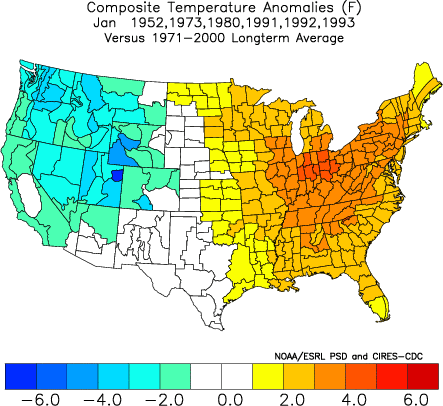
January:

February:
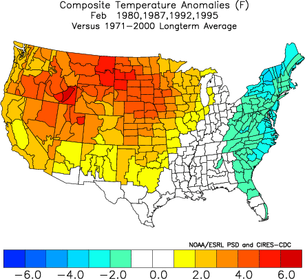
The turn to cooler in the East in February also fits seasons in which December saw the Arctic Oscillation average +1.000 or above and the Winter Multivariate ENSO Index (MEI) was above 0. The outcome is similar if one uses a +0.500 threshold for the MEI.
January:
February:

For what it is worth, the addition of 1958-59 into the pool does not materially change either the January or February outlooks. It should be noted that a number of the above seasons saw a brief return of much above normal temperatures before the generally colder pattern set up for February a la a Battle of the Bulge-type bid to hold back winter. So, for those clamoring for change, there remains reason for some optimism down the road. However, before such changes take place, the more immediate situation will concern more warmth and then a pattern change that will likely commence in the January 10-20 timeframe.
My thinking for the average temperature anomalies during the 1/8-15 period is as follows:
Average Regional Temperature Anomalies (1/8-15):
Northeast: Above normal to much above normal
Mid-Atlantic: Above normal
Southeast: Near normal to somewhat above normal
Great Lakes: Above to much above normal
Northern Plains: Above to much above normal
Central Plains: Above normal
Southern Plains: Above normal
Pacific Northwest: Somewhat below normal to near normal
Southwest/Rest of West Coast: Near normal
For the major cities from Washington, DC to Boston, the 1/8-15 period is likely to feature:
- Nights generally in the 30s. Some 20s are possible in Boston.
- Days mainly in the 40s and 50s throughout the region.
- One or more days with a high temperature of 60° is possible throughout the region.
In the Southeast, Atlanta will likely see highs generally in the 50s and 60s. Lows should generally be in the 30s and 40s. Burlington will likely see highs mainly in the 30s and 40s. A 50° day is possible there.
Historic Tidbit:
Summary of Winter 1816-17 in Philadelphia: “The winter of 1817 was moderate, until the middle of January, when the Delaware closed, and so continued until the 9th of March.” (Source: Philadelphia U.S. Gazette).
To all, have a Happy New Year!