
NYZ006>008-031200-
/O.CON.KBUF.LE.W.0007.070203T0400Z-070205T1100Z/
OSWEGO-JEFFERSON-LEWIS-
INCLUDING THE CITIES OF...OSWEGO...WATERTOWN...LOWVILLE
1056 PM EST FRI FEB 2 2007
...LAKE EFFECT SNOW WARNING REMAINS IN EFFECT UNTIL 6 AM EST
MONDAY...
A LAKE EFFECT SNOW WARNING REMAINS IN EFFECT UNTIL 6 AM EST
MONDAY.
SOUTHWEST WINDS BEHIND A DEPARTING COLD FRONT WILL SHIFT TO THE
WEST OVERNIGHT. LAKES SNOW THAT ARE DEVELOPING CLOSE TO THE ST.
LAWRENCE RICER WILL THEN DROP SOUTH ACROSS THE REGION OVERNIGHT
AND SETTLE OVER THE TUG HILL LATE TONIGHT THROUGH EARLY SATURDAY
BEFORE WEAKENING AND LIFTING NORTH OF WATERTOWN IN THE AFTERNOON.
A SECOND COLD FRONT WILL THEN CROSS THE REGION REINFORCING THE
LAKE SNOWS AND AGAIN SHIFTING THEM SOUTH ACROSS THE TUG HILL
SATURDAY NIGHT. THESE SQUALLS WILL PERSIST THROUGH SUNDAY AND
SUNDAY NIGHT.
FOUR TO SIX INCHES OF SNOW ARE EXPECTED OVERNIGHT WITH AN
ADDITIONAL SIX TO TWELVE INCHES ON SATURDAY. THERE IS THE
POTENTIAL FOR THREE TO AS MUCH AS FIVE FEET OF NEW SNOW IN THE
MOST PERSISTENT SNOW BY MONDAY MORNING.
STRONG WESTERLY WINDS WILL CREATE CONSIDERABLE BLOWING AND
DRIFTING...ESPECIALLY ON NORTH SOUTH ROADS.
IN LAKE EFFECT SNOW THE WEATHER CAN VARY FROM LOCALLY HEAVY SNOW
IN NARROW BANDS TO CLEAR SKIES JUST A FEW MILES AWAY. IF YOU WILL
BE TRAVELING ACROSS THE REGION BE PREPARED FOR RAPID CHANGES IN
ROAD AND VISIBILITY CONDITIONS. STAY TUNED TO NOAA WEATHER RADIO
AND OTHER RADIO AND TV STATIONS FOR FURTHER DETAILS OR UPDATES.
$$
Update: 10 feet of snow reported in NY; storm continues
Moderator: S2k Moderators
Forum rules
 The posts in this forum are NOT official forecast and should not be used as such. They are just the opinion of the poster and may or may not be backed by sound meteorological data. They are NOT endorsed by any professional institution or STORM2K.

The posts in this forum are NOT official forecast and should not be used as such. They are just the opinion of the poster and may or may not be backed by sound meteorological data. They are NOT endorsed by any professional institution or STORM2K.
Update: 10 feet of snow reported in NY; storm continues
Last edited by nystate on Fri Feb 09, 2007 2:52 pm, edited 1 time in total.
0 likes
-
bob rulz
- Category 5

- Posts: 1711
- Age: 36
- Joined: Sat Jan 28, 2006 7:30 pm
- Location: Salt Lake City, Utah
Yeah, the Tug Hill Plateau can get some major snowfall accumulations from significant lake-effect events. With no real pattern change expected, there's supposed to be lake-effect snow all week. That 3-5 feet of snow is only expected to be through Monday morning!  It'll be very interesting to see how much snow falls up there when all is said and done.
0 likes
-
Matt-hurricanewatcher
Wow that slight cool down in overall global temps did a lot. 2005 was the warmest year, and I seen less then 1.5" inches of snow. It was a warm year across the US. But 2006-2007 winter I've had nearly 5 inches of snow. With the Midwest and East getting the biggest Arctic outbreak since 96. I think its turing around. In 20 years we will look back in say what where we thinking. 2006 turnes out to be 6th.
I forecast 8th for 2007.
I forecast 8th for 2007.
0 likes
matt what does this have to do with a specific thread concerning lake effect in upstate newyork
the lake effect guns have been going all out around water town yesterday through now
http://radar.weather.gov/radar.php?rid= ... 11&loop=no
so there has been between 1 to 1 and a half inches of liquid equivilant precip with temperatures around 15 degrees give or take for the last day which seems like a nice 25:1 ratio
so 25 to 36 or so inches with isolated 40 inches totals as of noon today
will keep updated
0 likes
Saw on the Watertown news website just now that earlier today all driving was banned in Jefferson and Lewis counties except in the case of emergencies. Conditions were so bad that the only major interstate in the area was closed and people were advised to ditch their cars on the side of the road and hitch a ride home with police and other emergency personell.
0 likes
-
donsutherland1
- S2K Analyst

- Posts: 2718
- Joined: Mon Sep 15, 2003 8:49 pm
- Location: New York


Watertown/Jefferson County still have LES Warnings up...Watertown has received 28 inches so far and NWS is calling for the potential of 1-2 more feet tonight.
Also, check out these storm reports from NWS-
6 HOUR SNOWFALL (INCHES)
MEXICO...........26
STORM TOTAL AS OF MIDDAY 2/6 (INCHES)
MEXICO..........57.0
OSWEGO.........43.6
I'm not going to lie, I miss it!
Also, great pics up above!
Also, check out these storm reports from NWS-
6 HOUR SNOWFALL (INCHES)
MEXICO...........26
STORM TOTAL AS OF MIDDAY 2/6 (INCHES)
MEXICO..........57.0
OSWEGO.........43.6
I'm not going to lie, I miss it!
Also, great pics up above!
0 likes
-
donsutherland1
- S2K Analyst
- Posts: 2718
- Joined: Mon Sep 15, 2003 8:49 pm
- Location: New York
Latest NWS forecast covering the period from late this afternoon through tomorrow for Pulaski, NY:
Late Afternoon: Periods of snow. The snow could be heavy at times. High near 17. Wind chill values between -2 and 3. Breezy, with a west wind around 21 mph, with gusts as high as 32 mph. Chance of precipitation is 100%. Total daytime snow accumulation of 17 to 23 inches possible.
Tonight: Periods of snow showers, mainly after 3am. The snow could be heavy at times. Low around 6. Wind chill values between -4 and -11. West wind between 15 and 18 mph. Chance of precipitation is 80%. New snow accumulation of 3 to 5 inches possible.
Wednesday: Periods of snow. The snow could be heavy at times. High near 20. Wind chill values between -1 and -11. West wind between 13 and 20 mph. Chance of precipitation is 90%. New snow accumulation of 13 to 19 inches possible.
Wednesday Night: Periods of snow. The snow could be heavy at times. Low around 8. Wind chill values between -1 and -10. West wind around 20 mph. Chance of precipitation is 80%.
0 likes

-
southerngale

- Retired Staff

- Posts: 27418
- Joined: Thu Oct 10, 2002 1:27 am
- Location: Southeast Texas (Beaumont area)
LOL Paul... I was thinking something similar. I am dying to get some snow...I want to build a snowman, have a snowball fight, make snow angels, etc. 
But I quite like being able to go outside without spending 15 minutes putting on layers so I don't turn into an instant icegirl when I walk outside.
But for a week or so... oh yeah!!
Great pictures, Don. Thanks for sharing!
But I quite like being able to go outside without spending 15 minutes putting on layers so I don't turn into an instant icegirl when I walk outside.
But for a week or so... oh yeah!!
Great pictures, Don. Thanks for sharing!
0 likes
-
donsutherland1
- S2K Analyst
- Posts: 2718
- Joined: Mon Sep 15, 2003 8:49 pm
- Location: New York
It appears that the LES won't be as extreme over the next 24 hours as it has been in recent days in which Parish, Oswego, Redfield, etc. were hammered. The following 12 hours, at least if the WRF verifies, may see a pickup in the intensity of the LES.
24-hour qpf:
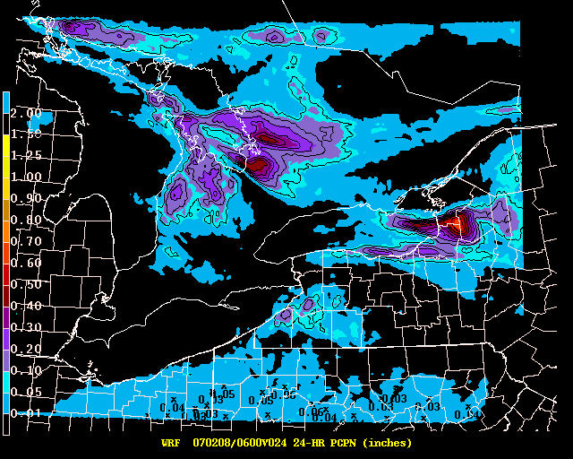
36-hour qpf:

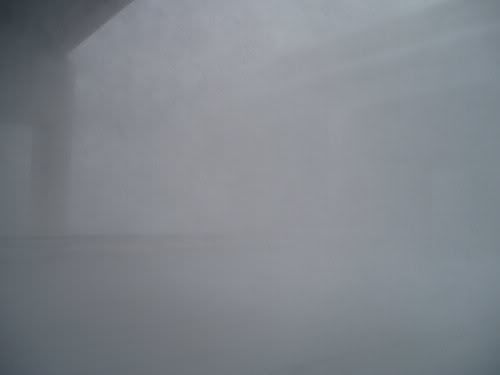
Additional photo from the LES event (Pulaski, New York):

24-hour qpf:
36-hour qpf:
Additional photo from the LES event (Pulaski, New York):
0 likes


-
Jim Cantore
Lake Effect Snow Warning
URGENT - WINTER WEATHER MESSAGE
NATIONAL WEATHER SERVICE BUFFALO NY
830 PM EST WED FEB 7 2007
NYZ006-080930-
/O.CON.KBUF.LE.W.0007.000000T0000Z-070209T1200Z/
OSWEGO-
INCLUDING THE CITY OF...OSWEGO
830 PM EST WED FEB 7 2007
...LAKE EFFECT SNOW WARNING REMAINS IN EFFECT UNTIL 7 AM EST
FRIDAY...
A LAKE EFFECT SNOW WARNING REMAINS IN EFFECT UNTIL 7 AM EST
FRIDAY.
INTENSE LAKE EFFECT SNOW WILL CONTINUE TO MEANDER ACROSS OSWEGO
COUNTY THROUGH THE END OF THE WEEK.
A BAND OF INTENSE LAKE EFFECT SNOW IS EXPECTED TO BECOME NEARLY
STATIONARY ACROSS NORTHERN OSWEGO COUNTY FROM LATE THIS AFTERNOON
THROUGH THURSDAY MORNING...MAINLY NORTH OF A LINE FROM SCRIBA TO
PARISH. THURSDAY AFTERNOON AND THURSDAY NIGHT THE BAND WILL BEGIN
TO MEANDER...AND WILL LIKELY SINK SOUTH INTO CENTRAL AND SOUTHERN
OSWEGO COUNTY AT TIMES. SNOWFALL RATES WILL REACH 4 TO 5 INCHES
PER HOUR UNDER THE MOST INTENSE PORTION OF THE BAND.
ADDITIONAL ACCUMULATIONS TONIGHT WILL REACH 2 TO 3 FEET IN THE
MOST PERSISTENT BANDS OVER THE NORTHERN SECTION OF THE COUNTY.
ANOTHER FOOT IS POSSIBLE THURSDAY...AND ANOTHER FOOT THURSDAY
NIGHT ACROSS MUCH OF THE COUNTY AS THE BAND MEANDERS SOUTH. THIS
WILL BRING STORM TOTALS FOR THE WEEK TO 100 INCHES OR MORE IN
SOME LOCATIONS.
IN ADDITION TO THE EXTREME SNOWFALL AMOUNTS...STRONG WINDS WILL
CREATE NEAR BLIZZARD CONDITIONS AT TIMES...ESPECIALLY NEAR THE
EDGES OF THE LAKE EFFECT SNOW BANDS WHERE WINDS ARE TYPICALLY
STRONGER THAN UNDER THE CENTER OF THE BAND.
TRAVEL WILL BE EXTREMELY DIFFICULT OR EVEN IMPOSSIBLE AT TIMES
THROUGH THURSDAY NIGHT...ESPECIALLY ON NORTH SOUTH ROADS SUCH AS
INTERSTATE 81.
$$
------------------------------------------------------------------------------
Thats insane!
0 likes
-
Hybrid ICE
- Posts: 0
- Joined: Thu Feb 08, 2007 7:49 am
- Location: Camp Hill. Pennsylvania
Who is online
Users browsing this forum: No registered users and 98 guests