December 3-10, 2007 Idea: Winter Strikes Early

Winter Weather Discussion

Moderator: S2k Moderators

Forum rules

The posts in this forum are NOT official forecast and should not be used as such. They are just the opinion of the poster and may or may not be backed by sound meteorological data. They are NOT endorsed by any professional institution or STORM2K.

Help Support Storm2K
Message
Author
donsutherland1
S2K Analyst
S2K Analyst
Posts: 2718
Joined: Mon Sep 15, 2003 8:49 pm
Location: New York

December 3-10, 2007 Idea: Winter Strikes Early

#1 Postby donsutherland1 » Fri Nov 23, 2007 3:18 pm

For some time, the ensemble guidance has been suggesting a widespread cold spell for the United States. Although one has seen the cold period gradually pushed into the future, odds favor the cold pushing into the United States and dominating much of the first week in December, beginning with the Northern Plains and then spreading eastward.

Some of the synoptic patterns similar to that shown on the long-range guidance have seen a fairly significant cold shot before the pattern moderated. In my opinion, the 12/3-10 timeframe will likely feature a cold shot that could send the coldest temperature into the 22°-27° range from Washington, DC (DCA) to Boston. There is a chance that Boston might see a sub-20° low. Several sub-40° highs are likely in each of these cities. Cities such as Toronto and Burlington will likely experience at least a single-digit low with one or more days featuring highs below 32°. Moreover, some of the aforementioned synoptic patterns featured modest accumulations of snow in such cities as New York, Boston, Burlington, and Toronto, not to mention the Great Lakes cities including Detroit and Chicago.

Beyond the timeframe, major questions lurk as to whether a dramatic pattern change to warmer lies ahead. Historic experience with a number of notable La Niña winters would suggest that such a pattern change could take place.

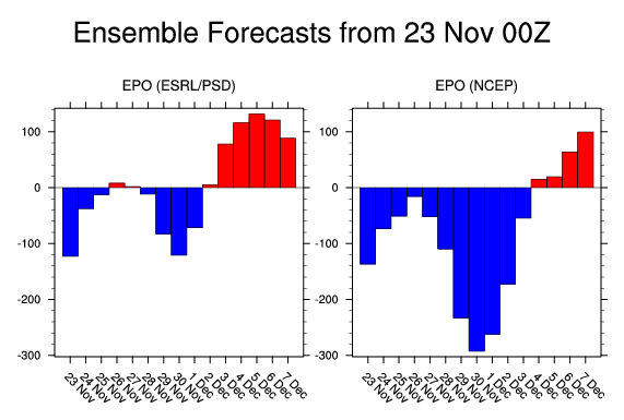
If one examines the latest EPO forecast, there are hints of a shift to a milder pattern, as the EPO is progged to rise to positive levels.

Image

However, some guidance points to a negative NAO and significant guidance still suggests a positive PNA. Hence, there is a chance that warming is delayed, particularly across New England.

In the longer-range, the ensemble guidance hints at the large pool of cold air that has covered much of Canada to be reduced. Whether or not this is will prove to be a hint of things to come remains to be seen.

For now, it appears that Winter 2007-08 will get off to a robust start in the East. But can the cold be sustained? That will be an issue that takes on added importance down the road, as a cold December during moderate or strong La Niña winters has often telegraphed a cooler than normal winter. On the other hand, a warm December has often signaled what became a warmer than normal winter.

Average Regional Temperature Anomalies (12/3-10):
Northeast: Below normal
Mid-Atlantic: Below normal
Southeast: Near normal
Great Lakes: Below normal
Northern Plains: Much below normal to below normal
Central Plains: Below normal
Southern Plains: Somewhat below normal to near normal
Pacific Northwest: Near normal to somewhat above normal
Southwest/Rest of West Coast: Above normal
0 likes   

User avatar
Ptarmigan
Category 5
Category 5
Posts: 5313
Joined: Wed Aug 16, 2006 9:06 pm

Re: December 3-10, 2007 Idea: Winter Strikes Early

#2 Postby Ptarmigan » Fri Nov 23, 2007 4:11 pm

Sounds kinda like December of 1989. It was really cold I remember. Arctic blast after Arctic blast came to Texas that time. Do you think we could see a repeat of December of 1989?
0 likes   

Miss Mary

#3 Postby Miss Mary » Fri Nov 23, 2007 7:20 pm

I remember 1989 - it was frigid! I recall a low of -21 one morning. Brrrr!
0 likes   

RL3AO
Moderator-Pro Met
Moderator-Pro Met
Posts: 16308
Joined: Thu Jun 14, 2007 10:03 pm
Location: NC

#4 Postby RL3AO » Fri Nov 23, 2007 7:25 pm

We better get some of these in January. I haven't seen a -15 morning in 4 years.
0 likes   

JonathanBelles
Professional-Met
Professional-Met
Posts: 11430
Age: 35
Joined: Sat Dec 24, 2005 9:00 pm
Location: School: Florida State University (Tallahassee, FL) Home: St. Petersburg, Florida
Contact:

#5 Postby JonathanBelles » Fri Nov 23, 2007 8:27 pm

Is it just me or does this winter (so far) seem more below normal than above like predicted?
0 likes   

RL3AO
Moderator-Pro Met
Moderator-Pro Met
Posts: 16308
Joined: Thu Jun 14, 2007 10:03 pm
Location: NC

Re:

#6 Postby RL3AO » Fri Nov 23, 2007 8:35 pm

fact789 wrote:Is it just me or does this winter (so far) seem more below normal than above like predicted?


Technically it isn't winter yet. Plus those 3-month predictions are for Dec-Jan-Feb.
0 likes   

JonathanBelles
Professional-Met
Professional-Met
Posts: 11430
Age: 35
Joined: Sat Dec 24, 2005 9:00 pm
Location: School: Florida State University (Tallahassee, FL) Home: St. Petersburg, Florida
Contact:

Re: Re:

#7 Postby JonathanBelles » Fri Nov 23, 2007 8:38 pm

RL3AO wrote:
fact789 wrote:Is it just me or does this winter (so far) seem more below normal than above like predicted?


Technically it isn't winter yet. Plus those 3-month predictions are for Dec-Jan-Feb.


I know that much....
0 likes   

User avatar
Lowpressure
S2K Supporter
S2K Supporter
Posts: 2032
Age: 58
Joined: Sun Sep 14, 2003 9:17 am
Location: Charlotte, North Carolina

Re:

#8 Postby Lowpressure » Fri Nov 23, 2007 8:54 pm

fact789 wrote:Is it just me or does this winter (so far) seem more below normal than above like predicted?


I was thinking the same thing. There was a lot of talk and forecasts for a nasty warm winter. Thanksgiving into Dec hints at something else. Many of us are glad to see a cooler and wetter pattern.
0 likes   

jinftl
Category 5
Category 5
Posts: 4312
Joined: Tue Aug 31, 2004 4:47 pm
Location: fort lauderdale, fl

Re: December 3-10, 2007 Idea: Winter Strikes Early

#9 Postby jinftl » Sat Nov 24, 2007 1:40 am

Perhaps because October was such a warm month across the U.S., that temps in November that have been average and in some cases below average (mainly from 11/4 - 11/10 timeframe) in the East seem colder...

Image

Image


Image

Image
0 likes   

richtrav
Tropical Storm
Tropical Storm
Posts: 184
Joined: Mon Sep 19, 2005 9:48 pm
Location: South Texas

Re: December 3-10, 2007 Idea: Winter Strikes Early

#10 Postby richtrav » Sat Nov 24, 2007 2:17 am

Ptarmigan wrote:Sounds kinda like December of 1989. It was really cold I remember. Arctic blast after Arctic blast came to Texas that time. Do you think we could see a repeat of December of 1989?


Hopefully we won't see another '89 within our lifetime, that was devastating. Heck, we haven't even had anything like the wimpier '82 or '85 freezes in Texas since 1990, they seemed to have just gone away
0 likes   

User avatar
tropicana
Category 5
Category 5
Posts: 8056
Joined: Sat Sep 27, 2003 6:48 pm
Location: Niagara Falls, Ontario, Canada
Contact:

Re: December 3-10, 2007 Idea: Winter Strikes Early

#11 Postby tropicana » Sun Nov 25, 2007 10:42 am

some media outlets here in Toronto are already picking up on that early December Arctic snap headed our way. This surely would be a slap in the face of most people in Southern Ontario, especially since we havent seen any major long lasting Pre-Christmas cold snaps for several years at least.
but im excited :cold:
0 likes   

pawxguy
Tropical Low
Tropical Low
Posts: 48
Joined: Fri Apr 09, 2004 6:43 pm
Location: Carbon Co. PA

Re: December 3-10, 2007 Idea: Winter Strikes Early

#12 Postby pawxguy » Sun Nov 25, 2007 10:57 pm

I'm also excited about the consistency of the models showing some winter wx for the end of the first December weekend. We got 6 days to watch this evolve.
0 likes   

pawxguy
Tropical Low
Tropical Low
Posts: 48
Joined: Fri Apr 09, 2004 6:43 pm
Location: Carbon Co. PA

Re: December 3-10, 2007 Idea: Winter Strikes Early

#13 Postby pawxguy » Mon Nov 26, 2007 5:10 pm

The latest news is that for my area NE PA we have below freezing temps from December 2-December 8 after receiving a nice amount of snow Sunday into Monday. Temps approaching 0F. in some places. Like I previously mentioned, we have a lengthy time to watch the approach of this potentially startling event for some of us from PA/NJ on northeastward
0 likes   

User avatar
tropicana
Category 5
Category 5
Posts: 8056
Joined: Sat Sep 27, 2003 6:48 pm
Location: Niagara Falls, Ontario, Canada
Contact:

Re: December 3-10, 2007 Idea: Winter Strikes Early

#14 Postby tropicana » Mon Nov 26, 2007 10:33 pm

as it draws closer and closer, im getting more and more excited.
On the way home tonight from work, some pretty heavy snow was falling also, this is just north of the city of Toronto, and this doesnt even include whats coming for perhaps the end of the weekend next weekend.
YAY YAY
0 likes   

User avatar
Stephanie
S2K Supporter
S2K Supporter
Posts: 23843
Age: 62
Joined: Thu Feb 06, 2003 9:53 am
Location: Glassboro, NJ

Re: December 3-10, 2007 Idea: Winter Strikes Early

#15 Postby Stephanie » Thu Nov 29, 2007 8:52 pm

Well, there is a possibility of snow changing to rain from overnight Saturday to Sunday here. It's pretty borderline and it all depends upon when the storm starts. Sunday's high is supposed to be about 42 degrees.

I like the feeling of it feeling like the Christmas season. Halloween was too weird - I was still wearing shorts up until a few days before it. This past year seems like each season was delayed by a month.
0 likes   

User avatar
tropicana
Category 5
Category 5
Posts: 8056
Joined: Sat Sep 27, 2003 6:48 pm
Location: Niagara Falls, Ontario, Canada
Contact:

Re: December 3-10, 2007 Idea: Winter Strikes Early

#16 Postby tropicana » Fri Nov 30, 2007 6:49 pm

Winter Storm Watches are up for all of South and South Central Ontario, including the city of Toronto for winter weather coming in Saturday night and Sunday. That storm is all the way in Colorado tonight.

-justin-
0 likes   

donsutherland1
S2K Analyst
S2K Analyst
Posts: 2718
Joined: Mon Sep 15, 2003 8:49 pm
Location: New York

#17 Postby donsutherland1 » Wed Dec 12, 2007 9:21 am

Verification:

Initial Post: November 23, 2007

Some of the synoptic patterns similar to that shown on the long-range guidance have seen a fairly significant cold shot before the pattern moderated. In my opinion, the 12/3-10 timeframe will likely feature a cold shot that could send the coldest temperature into the 22°-27° range from Washington, DC (DCA) to Boston. There is a chance that Boston might see a sub-20° low. Several sub-40° highs are likely in each of these cities. Cities such as Toronto and Burlington will likely experience at least a single-digit low with one or more days featuring highs below 32°.

Lowest Temperature:
Boston: 19°, 12/6
Burlington: 4°, 12/6
New York City: 21°, 12/6
Philadelphia: 20°, 12/6
Toronto: 12° (-11.1°C), 12/5
Washington, DC (DCA): 23°, 12/6

Lowest Maximum Temperature:
Boston: 30°, 12/4
Burlington: 20°, 12/10
New York City: 33°, 12/5-6
Philadelphia: 31°, 12/5
Toronto: 19° (-7.3°C), 12/5
Washington, DC (DCA): 33°, 12/5

Days with Maximum Temperatures < 40°:
Boston: 6
Burlington: 8
New York City: 4
Philadelphia: 4
Toronto: 8
Washington, DC (DCA): 3

Days with Maximum Temperatures < 32°:
Burlington: 6
Philadelphia: 1
Toronto: 4

Moreover, some of the aforementioned synoptic patterns featured modest accumulations of snow in such cities as New York, Boston, Burlington, and Toronto, not to mention the Great Lakes cities including Detroit and Chicago.

Biggest snowfall:

Boston: 1.3”, 12/2-3
Burlington: 8.2”, 12/3-4
New York City: 1.4”, 12/2-3
Philadelphia: 2.6” 12/5
Toronto: 5.7” (14.6 cm), 12/2
Washington, DC (DCA): 2.6”, 12/5

Average Regional Temperature Anomalies (12/3-10):
Northeast: Below normal; Actual: Below normal
Mid-Atlantic: Below normal; Actual: Somewhat below normal to near normal
Southeast: Near normal; Actual: Above normal
Great Lakes: Below normal; Actual: Below normal
Northern Plains: Much below normal to below normal; Actual: Much below normal
Central Plains: Below normal; Actual: below normal
Southern Plains: Somewhat below normal to near normal; Actual: Somewhat above normal
Pacific Northwest: Near normal to somewhat above normal; Actual: Somewhat above normal
Southwest/Rest of West Coast: Above normal; Actual: Somewhat above normal
0 likes   


Return to “Winter Weather”

Who is online

Users browsing this forum: No registered users and 15 guests