 The posts in this forum are NOT official forecast and should not be used as such. They are just the opinion of the poster and may or may not be backed by sound meteorological data. They are NOT endorsed by any professional institution or

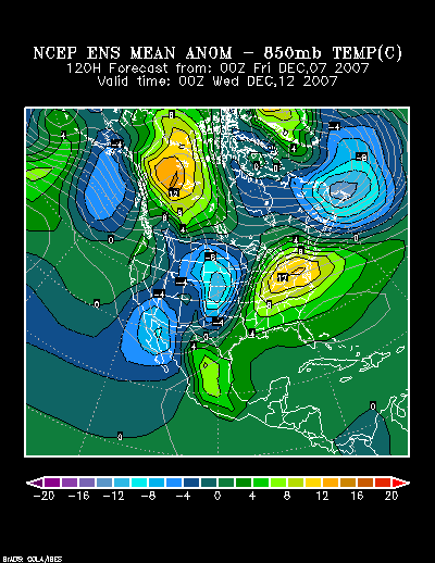
12/7 0z NCEP Ensemble Mean 850 mb Temperature Anomalies: 120 hours:
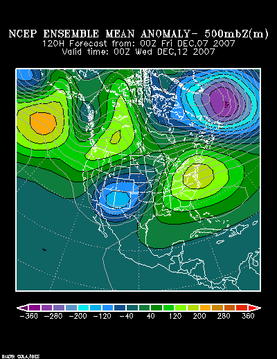
A look at the mean 500 mb anomalies shown on the NCEP ensemble suite shows some similarity to a composite from 12/5/1960 and 12/11/1985:
12/7 0z NCEP Ensemble Mean 500 mb Height Anomalies: 120 hours:
Composite 500 mb Height Anomalies (12/5/1960 and 12/11/1985):
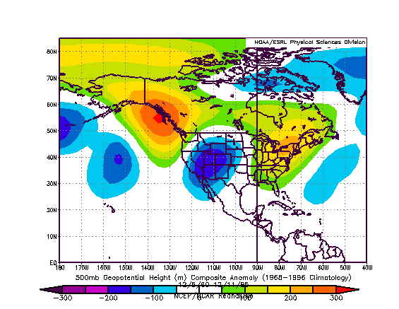
While each of the selected years in the composite agrees on Mid-Atlantic warmth, there are substantial differences in terms of the northern Mid-Atlantic region into southern New England. The 1960 idea is much warmer for such cities as New York City and Boston. During the 1960 warm shot, the temperature peaked above 60° in NYC and in the upper 50s in Boston. In the 1985 warm shot, cooler readings prevailed in both cities with highs peaking in the 40s.
Peak high temperatures for each of the above-noted warm periods were as follows:
12/4-7/1960:
Atlanta: 68°
Boston: 57°
New York City: 64°
Philadelphia: 62°
Raleigh: 74°
Richmond: 73°
Washington, DC (DCA): 67°
12/9-12/1985:
Atlanta: 73°
Boston: 43°
New York City: 49°
Philadelphia: 60°
Raleigh: 67°
Richmond: 72°
Washington, DC (DCA): 65°
In my opinion, the lower level cold will take a little longer to scour out of the Northeast. As a result, I believe that area’s temperatures will probably wind up closer to those of 1985 than in 1960. From the Mid-Atlantic region southward, the warmth will prevail and both analogs appear reasonable in terms of the magnitude. The big issue will concern cloud cover and/or precipitation. At this time, I believe Boston will see its highest temperature peak at 47° or above (50° is possible on one day, but not assured). NYC should reach at least 53° at its highest and Philadelphia should top out at 58° or above. Washington, DC should reach 65° or above on its warmest day. Atlanta, Raleigh, and Richmond will probably reach 70° or above on one or more days.


