January 1-7, 2008 Idea: Desert Southwest To Bake

Winter Weather Discussion

Moderator: S2k Moderators

Forum rules

The posts in this forum are NOT official forecast and should not be used as such. They are just the opinion of the poster and may or may not be backed by sound meteorological data. They are NOT endorsed by any professional institution or STORM2K.

Help Support Storm2K
Message
Author
donsutherland1
S2K Analyst
S2K Analyst
Posts: 2718
Joined: Mon Sep 15, 2003 8:49 pm
Location: New York

January 1-7, 2008 Idea: Desert Southwest To Bake

#1 Postby donsutherland1 » Fri Dec 21, 2007 9:30 am

The New Year could start off with cold winds in the East in the wake of an important storm that could affect parts of that region toward the close of 2007. However, as the opening days of the month proceed, it appears that an area of excessive warmth could attempt to expand eastward from the Desert Southwest.

Overall, the first week in January looks to remain quite wet in the Pacific Northwest. The Desert Southwest could see little or no precipitation through the duration of the period.

During the January 1-7 timeframe, the EPO is forecast to be positive. A sharply negative PNA is likely to slowly rise. Overall, the teleconnection indices favor a generally mild regime for much of the U.S.

Certainly, the objective analogs are doing their part to paint just such a picture. Whether one looks at the GFS, ECM, Canadian, or Superensemble analogs, there is a consensus in favor of warmth. As a caveat, it should be noted that the objective analogs have been overplaying the warmth as of late. Hence, my thinking is cooler than what is implied by the objective analogs.

Finally, beyond the opening week of 2008, even as Presidential campaigning heats up, there are hints that temperatures could cool down. If one examines the latest NCEP ensemble mean 500 mb height anomalies one sees the progression of above normal height anomalies toward Greenland.

Image
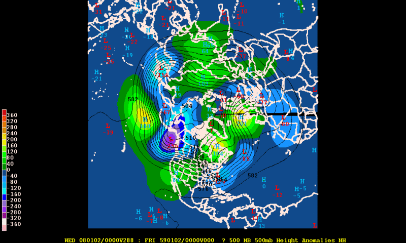
NCEP Ensemble Maps are Courtesy of RaleighWX’s GEMPAK program

If that development works out, one could see a colder regime begin to establish itself around January 10 +/- a few days. Still, much can change given how far into the future that is.

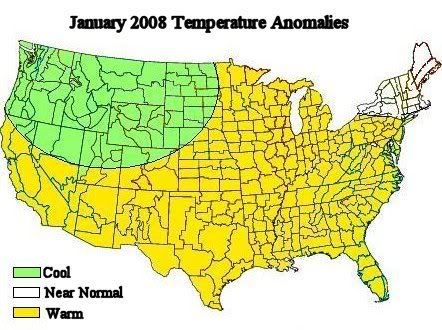
As for January as a whole, my thinking is that New England will wind up with near normal readings (the same should hold true for southern Ontario and southern Quebec). The Pacific Northwest will wind up on the cooler side of normal. Even in the Mid-Atlantic region where milder anomalies are likely, there should be sufficient variability, especially if blocking develops, to promote some opportunities for winter weather. What is increasingly likely is that January 2008 will not resemble January 1950 in terms of the magnitude of warm anomalies.

Image

Average Regional Temperature Anomalies (January 1-7, 2008):
Northeast: Somewhat above normal
Mid-Atlantic: Near normal to somewhat above normal
Southeast: Near normal to somewhat above normal
Great Lakes: Somewhat above normal
Northern Plains: Above normal
Central Plains: Above normal
Southern Plains: Above normal
Pacific Northwest: Near normal to somewhat above normal
Southwest/Rest of West Coast: Much above normal

Best Guess of Regional Temperature Anomalies (°F):
Northeast: +1° to +3°
Mid-Atlantic: 0° to +2°
Southeast: 0° to +2°
Great Lakes: +1° to +3°
Northern Plains: +3° to +5°
Central Plains: +3° to +5°
Southern Plains: +3° to +5°
Pacific Northwest: 0° to +2° (coolest on the Coast)
Southwest/Rest of West Coast: +7° to +9° (cooler in California)
0 likes   

sphinx
Tropical Depression
Tropical Depression
Posts: 51
Joined: Fri Feb 20, 2004 8:26 pm

Re: January 1-7, 2008 Idea: Desert Southwest To Bake

#2 Postby sphinx » Mon Dec 24, 2007 2:42 pm

Cooler than January 1950!

Small comfort for us snow lovers in Maryland. The mean January temperature at BWI in January 1950 was 47 degrees. 15 degrees above normal.

It was warm throughout the eastern U.S. that year. e.g., parts of southeastern Iowa exceeded 70 degrees. Keokuk reached 73 on the 5th, the all-time January high for the state.

Of course, the mid-Atlantic's snow distribution is so skewed, it only takes one big storm to have an above average winter.
0 likes   

JonathanBelles
Professional-Met
Professional-Met
Posts: 11430
Age: 35
Joined: Sat Dec 24, 2005 9:00 pm
Location: School: Florida State University (Tallahassee, FL) Home: St. Petersburg, Florida
Contact:

#3 Postby JonathanBelles » Mon Dec 24, 2007 3:06 pm

What do you think about the arctic blast in the GFS?
0 likes   

User avatar
Portastorm
Storm2k Moderator
Storm2k Moderator
Posts: 9914
Age: 63
Joined: Fri Jul 11, 2003 9:16 am
Location: Round Rock, TX
Contact:

Re: January 1-7, 2008 Idea: Desert Southwest To Bake

#4 Postby Portastorm » Mon Dec 24, 2007 6:03 pm

Fact, I was going to ask Don the same thing.

Don ... I'm a great admirer of your knowledge and posts. However, if the GFS operational runs and the latest European are correct, we will see a major Arctic blast hit the Southern Plains and I have to believe those temps in the Jan. 1-7 time frame would average out to normal if not below normal even with a warming trend following the Arctic plunge.

Nevertheless, it's hard to argue against the teleconnections so I guess this is one of those "we shall see" deals. :wink:
0 likes   

User avatar
Aslkahuna
Professional-Met
Professional-Met
Posts: 4550
Joined: Thu Feb 06, 2003 5:00 pm
Location: Tucson, AZ
Contact:

Re: January 1-7, 2008 Idea: Desert Southwest To Bake

#5 Postby Aslkahuna » Tue Dec 25, 2007 7:46 pm

Looking at the runs-which have to be take with a grain of salt still, it looks as though NM and eastern AZ east of the Santa Ritas will get easterly flow and a backdoor pattern. While easterly flow is downslope in Tucson and can be warm, in eastern AZ it can turn a warm ridge pattern into crap with low level CAA. This appears to be the pattern from the first through the third of January and it will not be until the ridge translates further east (at which point it begins to flatten) that we will warm up much here in Cochise County and dollars will get you donuts that the ridge will dirty up and we will get high clouds putting the cap on any warm up. I've seen easterly flow ruin a January warmup for us too many times to be excited over a western US ridge.

Steve
0 likes   

User avatar
Cyclenall
Category 5
Category 5
Posts: 6666
Joined: Thu Jun 08, 2006 10:01 pm
Location: Ontario, Canada

#6 Postby Cyclenall » Thu Dec 27, 2007 12:21 pm

The 14-day trend as of today shows a huge warming spell for the Great Lakes region with temps. going up to the +5C to +9C range by January 8th. Can you imagine it being +12C on Jan.9 in Windsor :lol: . Does this have anything to do with this idea?

I will post some 14-day trends from The Weather Network to show this.
0 likes   

User avatar
azsnowman
Category 5
Category 5
Posts: 8591
Joined: Wed Feb 05, 2003 8:56 pm
Location: Pinetop Arizona. Elevation 7102' (54 miles west of NM border)

#7 Postby azsnowman » Sat Dec 29, 2007 6:11 pm

WELL....everyone (NWS and others) predicted a above normal December temp wise and below normal snowpack...fact is, it was SO OPPOSITE :lol:

Average temps for the month of Dec. for me has been 12-18° below normal, snowpack is now 29" above the norm of 13". I've had 42" of snow with 16" still on the ground with the frost line down just 1" below ground level. Coldest night time temp so far, -4°F, average low, 25-27°. Average daytime temp over the past 3 weeks, 29-31°, coldest daytime temp was 22° just 2 days ago.

SO...as you can see, the desert southwest is SO hard to predict as Steve said (like I'm the expert :ggreen: :roll: ).

For all intents and purposes, let's hope your wrong don! Great analysis however :wink:
0 likes   

User avatar
Aslkahuna
Professional-Met
Professional-Met
Posts: 4550
Joined: Thu Feb 06, 2003 5:00 pm
Location: Tucson, AZ
Contact:

Re: January 1-7, 2008 Idea: Desert Southwest To Bake

#8 Postby Aslkahuna » Tue Jan 01, 2008 2:57 pm

Sheesh, I hate it when I'm right like this- Easterly winds have kicked in and today's highs are 10 degrees lower than yesterday's which were in the mid 60's which is not baking weather for us. The winds will keep us down through tomorrow and then Thursday we have a chance for one decent day before we get into a trough pattern this weekend which, among other things, will send us back to a late December temperature pattern. Looks like decent snow for Azsnowman again.

Steve
0 likes   

User avatar
azsnowman
Category 5
Category 5
Posts: 8591
Joined: Wed Feb 05, 2003 8:56 pm
Location: Pinetop Arizona. Elevation 7102' (54 miles west of NM border)

Re: January 1-7, 2008 Idea: Desert Southwest To Bake

#9 Postby azsnowman » Tue Jan 01, 2008 3:32 pm

Aslkahuna wrote:Sheesh, I hate it when I'm right like this- Easterly winds have kicked in and today's highs are 10 degrees lower than yesterday's which were in the mid 60's which is not baking weather for us. The winds will keep us down through tomorrow and then Thursday we have a chance for one decent day before we get into a trough pattern this weekend which, among other things, will send us back to a late December temperature pattern. Looks like decent snow for Azsnowman again.

Steve


And right you are Steve....those friggin' N-NE are a REAL pain again today! Haven't broke 30° all day and like you said, this NEXT system is supposed to be a REAL sunny beach :ggreen: The snowfall rate for these up and coming systems are supposed to be measured in FEET, not inches!
0 likes   

donsutherland1
S2K Analyst
S2K Analyst
Posts: 2718
Joined: Mon Sep 15, 2003 8:49 pm
Location: New York

#10 Postby donsutherland1 » Mon Jan 14, 2008 11:59 am

Verification:

Overall, the first week in January looks to remain quite wet in the Pacific Northwest. The Desert Southwest could see little or no precipitation through the duration of the period.

Precipitation in the Pacific Northwest and Desert Southwest was somewhat above normal. The wetter regime in the Desert Southwest blunted the warmth e.g., surface anomalies were less pronounced than the 850 mb anomalies. Hence, the precipitation contributed to a busted forecast for the Southwest.

Average Regional Temperature Anomalies (January 1-7, 2008):
Northeast: Somewhat above normal; Actual: Somewhat above normal
Mid-Atlantic: Near normal to somewhat above normal; Actual: Near normal to somewhat above normal
Southeast: Near normal to somewhat above normal; Actual: Below normal
Great Lakes: Somewhat above normal; Actual: Above normal
Northern Plains: Above normal; Actual: Above to much above normal
Central Plains: Above normal; Actual: Above normal
Southern Plains: Above normal; Actual: Above normal
Pacific Northwest: Near normal to somewhat above normal; Actual: Near normal to somewhat above normal
Southwest/Rest of West Coast: Much above normal; Actual: Somewhat above normal to above normal

Best Guess of Regional Temperature Anomalies (°F):
Northeast: +1° to +3°; Actual: 0° to +2°
Mid-Atlantic: 0° to +2°; Actual: -2° to +2°
Southeast: 0° to +2°; Actual: -4° to 0°
Great Lakes: +1° to +3° Actual: +2° to +5°
Northern Plains: +3° to +5°; Actual: +4° to +8°
Central Plains: +3° to +5°; Actual: +2° to +5°
Southern Plains: +3° to +5°; Actual: +1° to +5°
Pacific Northwest: 0° to +2° (coolest on the Coast); -1° to +2° (the Oregon coast was coolest)
Southwest/Rest of West Coast: +7° to +9° (cooler in California); +1° to +3° (California was coolest)
0 likes   

User avatar
Aslkahuna
Professional-Met
Professional-Met
Posts: 4550
Joined: Thu Feb 06, 2003 5:00 pm
Location: Tucson, AZ
Contact:

Re: January 1-7, 2008 Idea: Desert Southwest To Bake

#11 Postby Aslkahuna » Mon Jan 14, 2008 11:53 pm

We did see 60F readings for part of the period but that's not January baking down here since our extreme highs here for the first week in January are in the 70's.

Steve
0 likes   


Return to “Winter Weather”

Who is online

Users browsing this forum: No registered users and 9 guests