 The posts in this forum are NOT official forecast and should not be used as such. They are just the opinion of the poster and may or may not be backed by sound meteorological data. They are NOT endorsed by any professional institution or

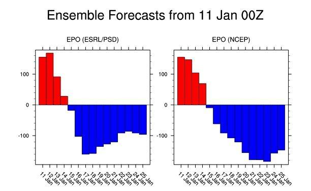
EPO Forecast:
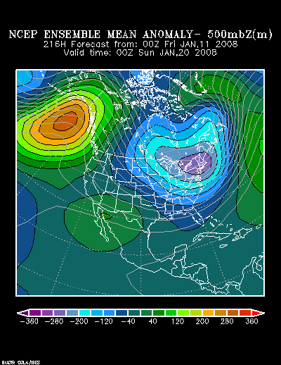
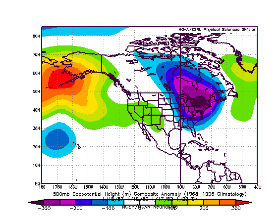
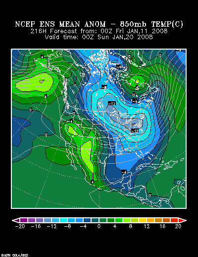
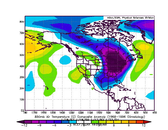
The forecast 500 mb height anomalies and 850 mb temperatures match up quite well with a composite analog centered from 1/18/1957, 1/18/1959, 1/17/1982, and 1/23/2004.
1/11/2008 0z NCEP Ensemble Mean 500 mb Height Anomalies at 216 hours:
Composite Analog 500 mb Height Anomalies:
1/11/2008 0z NCEP Ensemble Mean 850 mb Temperature Anomalies at 216 hours:
Composite Analog 850 mb Temperature Anomalies:
Although the pattern depicted on the NCEP ensemble suite is not the classic setup for extreme cold with a big PNA+ ridge, it is still similar to some past patterns that saw noticeable cold. In my opinion, there is a good possibility that much of the Mid-Atlantic region, Northeast, and southern Canada could experience their coldest readings so far this winter during the 1/18-25 timeframe.
Coldest Readings for Select Cities during Winter 2007-08:
Boston: 7°, 1/3
Burlington: -8°, 1/3
New York City: 12°, 1/3
Ottawa: -12° (-24.5°C), 1/3
Philadelphia: 18°, 1/3-4
Toronto: 0° (-17.7°C), 1/3
Washington, DC (DCA): 21°, 1/4
Given the reasonable consistency of the NCEP ensembles and analog set for similar 500 mb patterns, I believe Boston could see its coldest temperature reach 5° or below; New York City and Philadelphia should have at least one reading of 12° or colder with a single-digit reading possible in either city; Washington, DC (DCA) should bottom out at 16° or colder. Farther north, Toronto should see its coldest reading fall to -4° (-20.0°C) or colder; Burlington should reach -8° or lower and a -10° low temperature is possible; Ottawa should see its coldest reading fall to -13° (-25.0°C or colder).


