

Temperature Snapshot:
• Northeast: Warmer than normal
• Mid-Atlantic: Warmer than normal
• Southeast: Near normal to somewhat warmer than normal
• Northern Plains: Near normal
• Southern half of the United States (except California): Warmer than normal
• Elsewhere: Near normal
Precipitation Snapshot:
• Northeast: Below normal to near normal
• Mid-Atlantic: Below normal
• Southeast: Near normal but Florida Panhandle/eastern Gulf Coast normal to above normal (possible tropical activity—very strong signal for above normal precipitation with the ENSO regional data)
• Texas: below normal
In addition to the return of the warmth, the hottest temperatures will be noticeably hotter than last summer. Moreover, Boston, New York City, and Washington, DC will all see at least one heat wave (3 or more consecutive days with the temperature reaching 90° or above.
Boston:
Highest temperature: 96°-99°
90° days: 11 or more
Heatwaves: At least 1
New York City:
Highest temperature: 97°-100°
90° days: 18 or more
Heatwaves: 2 or more; 1 of at least 4 days
Washington, DC:
Highest temperature: 99°-102°
90° days: 36 or more
Heatwaves: 4 or more; 1 of at least 7 days
Additional Discussion:
Summers Following Weak El Niño Winters:
Summers that follow weak El Niño winters are typically warm in the Eastern United States.
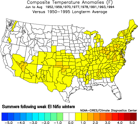
Since 1950, there have been 8 such summers: 1952, 1959, 1970, 1977, 1978, 1991, 1993, and 1994. With the exception of the Southeast, the large majority of such summers were normal to warmer than normal.
• Northeast: 6/8 (75%) Above normal temperatures
• Mid-Atlantic: 6/8 (75%) Above normal temperatures
• Southeast: 4/8 (50%) Above normal temperatures
ENSO Region Matches (March 2005 and Last 3 Months):
The 10 closest matches yielded an outcome very similar to that for summers following El Niño winters albeit with cooler anomalies and a much larger area of warmth in the western two-thirds of the United States.
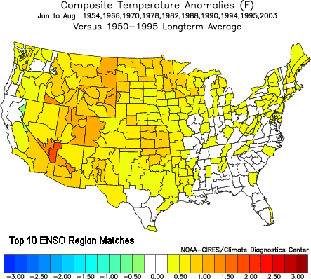
• Northeast: 7/10 (70%) Above normal temperatures
• Mid-Atlantic: 4/10 (40%) Above normal temperatures; 8/10 (80%) Normal to above normal temperatures
• Southeast: 4/10 (40%) Above normal temperatures; 4/10 (40%) Below normal temperatures
500 mb Upper Air Pattern:
The upper air pattern provided the least support for the warmer scenario and actually had somewhat cool anomalies for the Mid-Atlantic and Southeast:
• Northeast: 3/5 (60%) Above normal temperatures
• Mid-Atlantic: 3/5 (60%) Below normal temperatures
• Southeast: 3/5 (60%) Below normal temperatures
The upper air pattern has been skewed somewhat by the extreme February-March block that is only now near its end. Most summers that have followed extreme blocks (NAO bottomed out at –5.500 or below) have proved cooler than normal in the East. However, many of those blocks occurred during La Niña or Neutral ENSO conditions. Hence, while I have a degree of concern about this situation, given that there is greater support for the warmer scenario, I’ll hold to the warmer outcome for the most part.
Northern Hemisphere Snowcover profiles (October-February):
In the October-February period, 1982-83 has proved the closest match to 2004-05 in terms of Northern Hemisphere snowcover. The average monthly difference in Northern Hemisphere snowcover was 0.580 million square kilometers. The largest monthly difference was 0.9 million square kilometers. Summer 1983 was warmer than normal in both the Northeast and Mid-Atlantic and near normal to somewhat warmer than normal in the Southeast.
Last year, I did not use this indicator. However, after a review of the seasonal forecast debacle, I found that this indicator shed valuable light. The closest 5-month match to 2003-04 was 1999-00. The average monthly difference in Northern Hemisphere snowcover came to 0.580 million square kilometers. The largest monthly difference was 1.7 million square kilometers.
In Summer 2000, the Northeast and Mid-Atlantic regions were cooler than normal and the Southeast was normal to somewhat above normal in terms of temperatures. Summer 2004 had a similar profile:
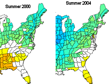
Given that trends in Northern Hemisphere snowcover might provide hints about the evolution of patterns that might not be fully captured in the global indices and the relevance of Northern Hemisphere snowcover for last summer, I have given added weight to this indicator for my temperature forecast for the eastern United States for this season. However, I am not using this indicator to predict eastern temperature anomalies but rather to help confirm what analogs based on the global indices are suggesting.
East Coast/Gulf of Mexico SSTAs:
In terms of prominent proximate features, February and March saw a pronounced and large area of cool anomalies around the Florida Peninsula and immediately off the East Coast. The most similar past profile for this geographic region occurred in the February-March 1988 period. March 1988 ranked 8th in terms of similarity to the March 2005 ENSO region anomalies. All said, in my view, this data helps reinforce the forecast stated above.
Key Assumptions:
• Neutral ENSO
• Positive PDO
• Cool SSTAs off the East Coast will fade slowly during the first half of summer
