April 1 Severe Wx: Hook-echo at 10AM? Precessor?
Moderator: S2k Moderators
Forum rules

The posts in this forum are NOT official forecast and should not be used as such. They are just the opinion of the poster and may or may not be backed by sound meteorological data. They are NOT endorsed by any professional institution or STORM2K.
-
CrazyC83
- Professional-Met

- Posts: 34315
- Joined: Tue Mar 07, 2006 11:57 pm
- Location: Deep South, for the first time!
MESOSCALE DISCUSSION 0396
NWS STORM PREDICTION CENTER NORMAN OK
0738 PM CST SAT APR 01 2006
AREAS AFFECTED...SERN NEB...NERN KS
CONCERNING...SEVERE THUNDERSTORM POTENTIAL
VALID 020138Z - 020315Z
...SEVERE THREAT IS INCREASING ACROSS SERN NEB AND NERN KS. SEVERE
THUNDERSTORM WATCH WILL BE ISSUED SOON...
SQUALL LINE WITH EMBEDDED SUPERCELL STRUCTURES IS BECOMING A BIT
MORE ORGANIZED AS IT LIFTS NEWD ACROSS CNTRL KS THIS EVENING. IT
APPEARS THIS ACTIVITY WILL PROGRESS EAST AND NORTH OF CURRENT
TORNADO WATCHES INTO A SLOWLY DESTABILIZING AIRMASS CAPABLE OF
MAINTAINING DAMAGING WINDS AND LARGE HAIL THREAT. STRENGTH OF UPPER
SHORTWAVE/ENHANCED LIFT SUGGEST SQUALL LINE WILL NOT DECREASE
SIGNIFICANTLY IN INTENSITY OVER THE NEXT FEW HOURS. SEVERE
THUNDERSTORM WATCH WILL LIKELY BE ISSUED SOON.
..DARROW.. 04/02/2006
ATTN...WFO...OAX...TOP...GID...
38689709 40089786 40439930 41319826 40489613 38379551
Sounds like Watch 125 will be issued soon? Will it be a Severe Thunderstorm Watch or a Tornado Watch?
Amended prediction maps coming up shortly.
0 likes

-
CrazyC83
- Professional-Met
- Posts: 34315
- Joined: Tue Mar 07, 2006 11:57 pm
- Location: Deep South, for the first time!
JUST IN - Severe Thunderstorm Watch 125
SEL5
URGENT - IMMEDIATE BROADCAST REQUESTED
SEVERE THUNDERSTORM WATCH NUMBER 125
NWS STORM PREDICTION CENTER NORMAN OK
855 PM CDT SAT APR 1 2006
THE NWS STORM PREDICTION CENTER HAS ISSUED A
SEVERE THUNDERSTORM WATCH FOR PORTIONS OF
NORTHEAST KANSAS
SOUTH CENTRAL AND SOUTHEAST NEBRASKA
EFFECTIVE THIS SATURDAY NIGHT AND SUNDAY MORNING FROM 855 PM UNTIL
300 AM CDT.
HAIL TO 1.5 INCHES IN DIAMETER...THUNDERSTORM WIND GUSTS TO 70
MPH...AND DANGEROUS LIGHTNING ARE POSSIBLE IN THESE AREAS.
THE SEVERE THUNDERSTORM WATCH AREA IS APPROXIMATELY ALONG AND 65
STATUTE MILES NORTH AND SOUTH OF A LINE FROM 15 MILES WEST
NORTHWEST OF KEARNEY NEBRASKA TO 35 MILES NORTHEAST OF MANHATTAN
KANSAS. FOR A COMPLETE DEPICTION OF THE WATCH SEE THE ASSOCIATED
WATCH OUTLINE UPDATE (WOUS64 KWNS WOU5).
REMEMBER...A SEVERE THUNDERSTORM WATCH MEANS CONDITIONS ARE
FAVORABLE FOR SEVERE THUNDERSTORMS IN AND CLOSE TO THE WATCH AREA.
PERSONS IN THESE AREAS SHOULD BE ON THE LOOKOUT FOR THREATENING
WEATHER CONDITIONS AND LISTEN FOR LATER STATEMENTS AND POSSIBLE
WARNINGS. SEVERE THUNDERSTORMS CAN AND OCCASIONALLY DO PRODUCE
TORNADOES.
OTHER WATCH INFORMATION...CONTINUE...WW 121...WW 122...WW 123...WW
124...
DISCUSSION...STRONG/SEVERE THUNDERSTORMS CURRENTLY OCCURRING OVER
PARTS OF CENTRAL KS AND SOUTH CENTRAL NEB ARE EXPECTED TO SPREAD
NORTHEASTWARD ACROSS THE WATCH AREA THIS EVENING. INSTABILITY IS
RATHER WEAK IN THIS REGION. HOWEVER...STRONG WIND FIELDS AND
FAVORABLE LARGE SCALE ASCENT WILL PROMOTE VIGOROUS UPDRAFTS CAPABLE
OF LARGE HAIL AND DAMAGING WINDS.
AVIATION...A FEW SEVERE THUNDERSTORMS WITH HAIL SURFACE AND ALOFT
TO 1.5 INCHES. EXTREME TURBULENCE AND SURFACE WIND GUSTS TO 60
KNOTS. A FEW CUMULONIMBI WITH MAXIMUM TOPS TO 500. MEAN STORM
MOTION VECTOR 24035.
Also, Severe Thunderstorm Watch 126 may be needed for Central Texas:
MESOSCALE DISCUSSION 0397
NWS STORM PREDICTION CENTER NORMAN OK
0753 PM CST SAT APR 01 2006
AREAS AFFECTED...SWRN TX
CONCERNING...SEVERE THUNDERSTORM POTENTIAL
VALID 020153Z - 020330Z
...SEVERE THUNDERSTORM WATCH MAY BE REQUIRED FOR PORTIONS OF
SWRN/CNTRL TX...
CONVECTION HAS RAPIDLY INCREASED OVER SWRN TX ALONG DRY LINE FROM
ERN PECOS COUNTY INTO REAGAN COUNTY. DRT SOUNDING AT 00Z WAS NOT
TERRIBLY CAPPED WITH WEAK MID LEVEL CAA NOTED AROUND 700MB. IT
APPEARS SRN END OF PLAINS SHORTWAVE TROUGH WILL EJECT ACROSS
PORTIONS OF CNTRL TX AIDING THIS CONVECTION IN THE SHORT TERM.
ALTHOUGH FWD SOUNDING EXHIBITED QUITE A BIT MORE INHIBITION...SHEAR
PROFILES SEEM FAVORABLE FOR SUSTAINING SQUALL LINE STRUCTURE AS IT
SPREADS ACROSS THE EDWARDS PLATEAU OVER THE NEXT SEVERAL HOURS.
SEVERE THUNDERSTORM WATCH MAY BE REQUIRED IF TRENDS CONTINUE.
..DARROW.. 04/02/2006
ATTN...WFO...SJT...MAF...
30700178 31520103 32200013 31669901 30630096
0 likes
-
SamSagnella
- Category 2

- Posts: 630
- Age: 39
- Joined: Fri Aug 26, 2005 12:02 pm
- Location: Westport, CT
- Contact:
Chase Report for April 1, 2006:
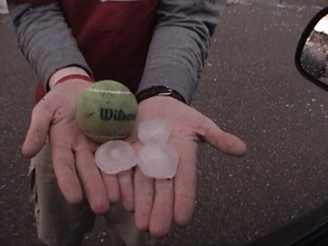
Left Norman at around 130 PM with an initial target of Weatherford (~75 miles west of OKC). Found a good wi-fi hotspot at the Holiday Inn Express right off I-40 in Weatherford and saw storms developing across the eastern Texas panhandle. We decided to target the northern storms and continued west to Clinton before turning north. We passed through Arapahoe and turned west on SR34(?), and before long a severe thunderstorm warning was issued for several counties in SWrn Okla. We decided that the best plan would be to continue west for several miles and then turn south, with the goal of dropping down behind the storm. During the time that we were approaching the storm from the north, several SVS/SVR were issued and it was humorous to note that hail size got larger with every single statement (i.e. "Hail the size of nickels is likely." then "Hail the size of half dollars is likely." and within minutes "Hail the size of baseballs is likely."). As the road we were on doglegged to the southeast (just NW of Sayre) we could see the precip core IMMEDIATELY in front of us and proceeded with extreme caution as the hail got progressively larger, and the CG lightning more intense. By the time it reached quarter size, we decided to turn around and we were out of the precip in less than a quarter mile. Below is a pic of the hail found on the side of the road.

After a few minutes of waiting we hopped back in the car and proceded towards Sayre, entering town just as the rain was coming to an end. We turned south at the stop light, towards I-40, and as we did so, smoke from what we assumed to be a lightning strike came into view. As we got closer, we realized that something large was on fire just passed the interstate -- it turned out to be a semi, the cab of which was completely engulfed in flames (the driver was OK), on the I-40 on-ramp.

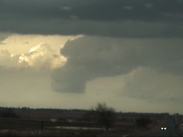
We continued past the truck and turned eastward after about a mile, where we could see a ragged looking wall cloud in front of us. After a minute or so on this road we realized that the hail piled up on the side of the road was pretty freaking large and we stopped to snap a couple of pictures.
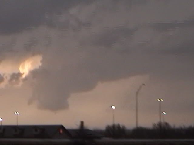
We continued onward for another couple of minutes before the crappy road network prevented us from going any further east. As we turned around and headed back to Sayre, the rotation became rain-wrapped and was completely obscured. The plan was to hop back on the interstate however, due to the smoldering truck still blocking the on-ramp, we headed north into the heart of town. As we were doing so, and interesting feature became visible to our north -- a textbook occluded mesocyclone.

We observed this feature for a few minutes before heading eastward towards Elk City, where a rainbow and intense lightning were visible in the wake of the transitioning storm.


The main show at this point was clearly the lightning, and after a round-about path southward to Burns Flat and back north to near Clinton, we headed back to Norman where we saw some breathtaking lightning and another casualty of a strike, this time a house in north Norman.


Left Norman at around 130 PM with an initial target of Weatherford (~75 miles west of OKC). Found a good wi-fi hotspot at the Holiday Inn Express right off I-40 in Weatherford and saw storms developing across the eastern Texas panhandle. We decided to target the northern storms and continued west to Clinton before turning north. We passed through Arapahoe and turned west on SR34(?), and before long a severe thunderstorm warning was issued for several counties in SWrn Okla. We decided that the best plan would be to continue west for several miles and then turn south, with the goal of dropping down behind the storm. During the time that we were approaching the storm from the north, several SVS/SVR were issued and it was humorous to note that hail size got larger with every single statement (i.e. "Hail the size of nickels is likely." then "Hail the size of half dollars is likely." and within minutes "Hail the size of baseballs is likely."). As the road we were on doglegged to the southeast (just NW of Sayre) we could see the precip core IMMEDIATELY in front of us and proceeded with extreme caution as the hail got progressively larger, and the CG lightning more intense. By the time it reached quarter size, we decided to turn around and we were out of the precip in less than a quarter mile. Below is a pic of the hail found on the side of the road.
After a few minutes of waiting we hopped back in the car and proceded towards Sayre, entering town just as the rain was coming to an end. We turned south at the stop light, towards I-40, and as we did so, smoke from what we assumed to be a lightning strike came into view. As we got closer, we realized that something large was on fire just passed the interstate -- it turned out to be a semi, the cab of which was completely engulfed in flames (the driver was OK), on the I-40 on-ramp.
We continued past the truck and turned eastward after about a mile, where we could see a ragged looking wall cloud in front of us. After a minute or so on this road we realized that the hail piled up on the side of the road was pretty freaking large and we stopped to snap a couple of pictures.
We continued onward for another couple of minutes before the crappy road network prevented us from going any further east. As we turned around and headed back to Sayre, the rotation became rain-wrapped and was completely obscured. The plan was to hop back on the interstate however, due to the smoldering truck still blocking the on-ramp, we headed north into the heart of town. As we were doing so, and interesting feature became visible to our north -- a textbook occluded mesocyclone.
We observed this feature for a few minutes before heading eastward towards Elk City, where a rainbow and intense lightning were visible in the wake of the transitioning storm.
The main show at this point was clearly the lightning, and after a round-about path southward to Burns Flat and back north to near Clinton, we headed back to Norman where we saw some breathtaking lightning and another casualty of a strike, this time a house in north Norman.
0 likes
Return to “USA & Caribbean Weather”
Who is online
Users browsing this forum: Brent and 96 guests