my first tornadoES 4/24/06

U.S. & Caribbean Weather Discussions and Severe Weather Events

Moderator: S2k Moderators

Forum rules

The posts in this forum are NOT official forecast and should not be used as such. They are just the opinion of the poster and may or may not be backed by sound meteorological data. They are NOT endorsed by any professional institution or STORM2K.

Help Support Storm2K
Message
Author
SamSagnella
Category 2
Category 2
Posts: 630
Age: 38
Joined: Fri Aug 26, 2005 12:02 pm
Location: Westport, CT
Contact:

my first tornadoES 4/24/06

#1 Postby SamSagnella » Tue Apr 25, 2006 2:37 am

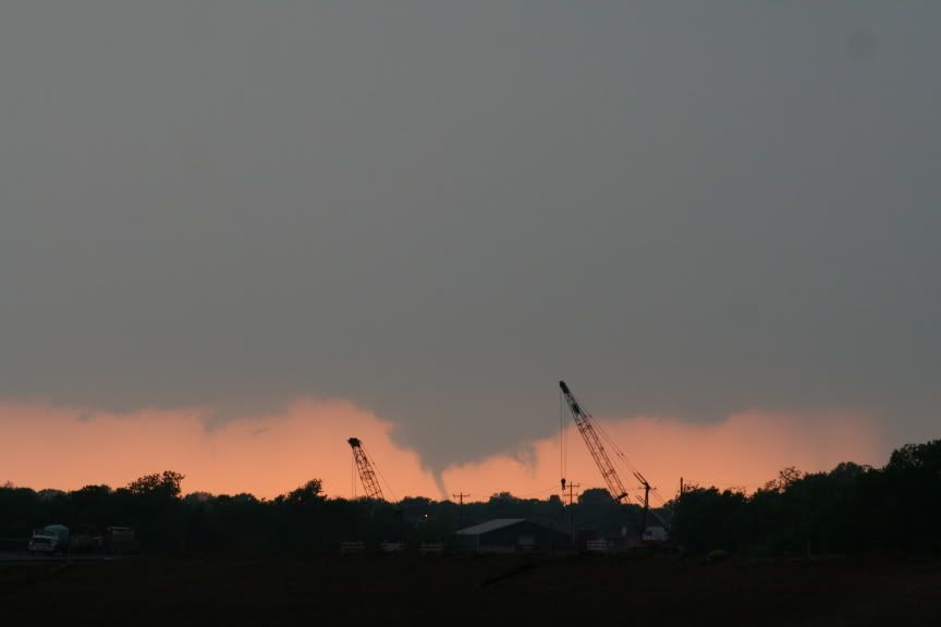
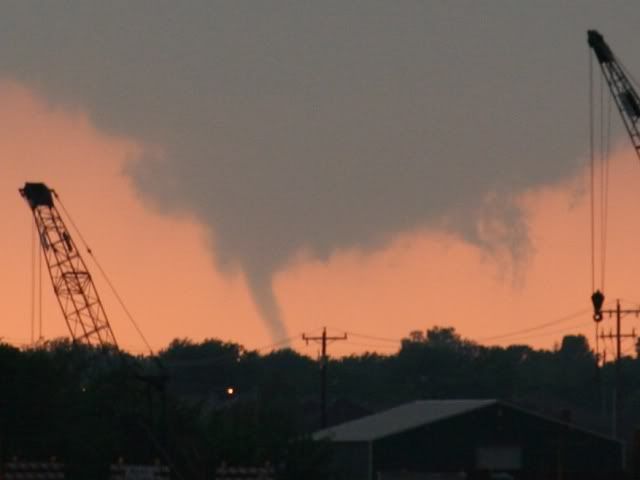
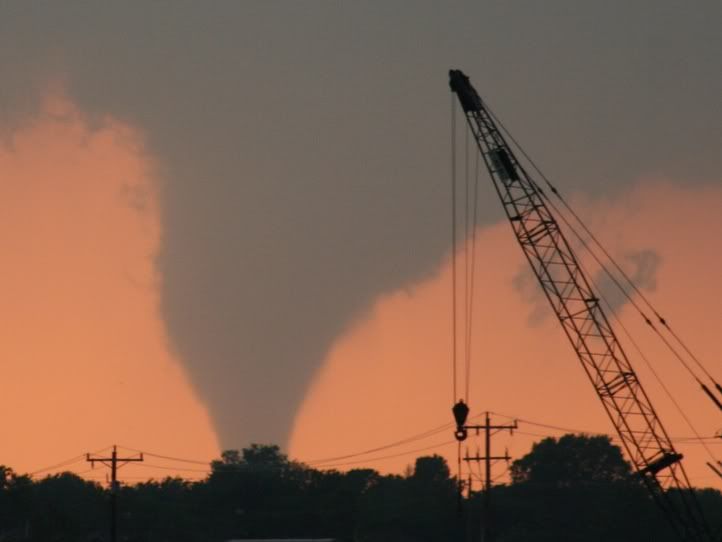
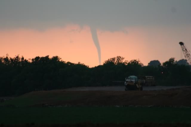
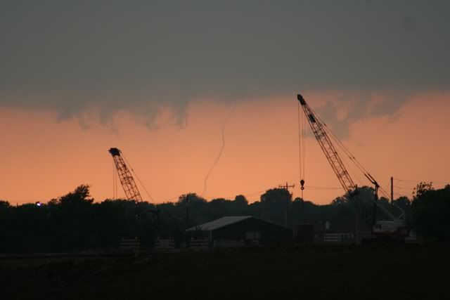
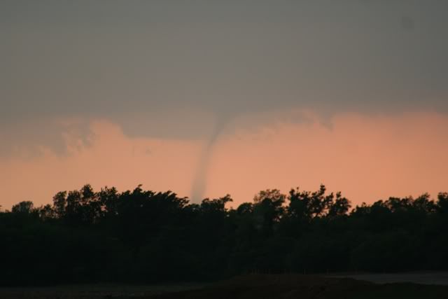
I will have a full chase report up sometime tomorrow, but I witnessed my first two tornadoes today in central Oklahoma, one of which was a classic anticyclonic.

EDIT: see below.
Last edited by SamSagnella on Thu Apr 27, 2006 2:02 pm, edited 2 times in total.
0 likes   

User avatar
Cookiely
S2K Supporter
S2K Supporter
Posts: 3211
Age: 74
Joined: Fri Aug 13, 2004 7:31 am
Location: Tampa, Florida

#2 Postby Cookiely » Tue Apr 25, 2006 5:40 am

Great pics. Thanks for sharing.
0 likes   

User avatar
vbhoutex
Storm2k Executive
Storm2k Executive
Posts: 29113
Age: 73
Joined: Wed Oct 09, 2002 11:31 pm
Location: Cypress, TX
Contact:

#3 Postby vbhoutex » Tue Apr 25, 2006 6:27 am

Nicely done Sam!!! Looking forward to the rest of the report.
0 likes   

User avatar
Weatherfreak14
Category 5
Category 5
Posts: 1383
Joined: Sat Sep 24, 2005 3:40 pm
Location: Beaufort, SC
Contact:

#4 Postby Weatherfreak14 » Tue Apr 25, 2006 7:00 am

Me too. Cant wait until I get out into OK and start my chasing.
0 likes   

conestogo_flood
Category 5
Category 5
Posts: 1268
Joined: Wed Sep 28, 2005 5:49 pm

#5 Postby conestogo_flood » Tue Apr 25, 2006 3:54 pm

Congratulations!
0 likes   

JonathanBelles
Professional-Met
Professional-Met
Posts: 11430
Age: 35
Joined: Sat Dec 24, 2005 9:00 pm
Location: School: Florida State University (Tallahassee, FL) Home: St. Petersburg, Florida
Contact:

#6 Postby JonathanBelles » Tue Apr 25, 2006 7:51 pm

nice pics
0 likes   

SamSagnella
Category 2
Category 2
Posts: 630
Age: 38
Joined: Fri Aug 26, 2005 12:02 pm
Location: Westport, CT
Contact:

#7 Postby SamSagnella » Tue Apr 25, 2006 9:41 pm

** Wall cloud about 5 min prior to first tornado touchdown
Image

** Tornado #1 touching down.
Image
zoomed in:
Image

**Tornado #1 1m30s after touchdown:
Image

**Tornado #1 3m30s after touchdown:
Image

**Tornado #1 5min after touchdown:
Image

More coming soon.
0 likes   

User avatar
wxmann_91
Category 5
Category 5
Posts: 8013
Age: 34
Joined: Fri Jul 15, 2005 2:49 pm
Location: Southern California
Contact:

#8 Postby wxmann_91 » Tue Apr 25, 2006 10:36 pm

Great photos Sam!! That's gotta be one in the "classic chase" column for those who bagged.
0 likes   

User avatar
x-y-no
Category 5
Category 5
Posts: 8359
Age: 65
Joined: Wed Aug 11, 2004 12:14 pm
Location: Fort Lauderdale, FL

#9 Postby x-y-no » Tue Apr 25, 2006 10:49 pm

Nice job!

Congrats on the successful chase - may there be many more. :-)
0 likes   

SamSagnella
Category 2
Category 2
Posts: 630
Age: 38
Joined: Fri Aug 26, 2005 12:02 pm
Location: Westport, CT
Contact:

#10 Postby SamSagnella » Tue Apr 25, 2006 11:02 pm

Thanks, Guys!

Tornado #1's rope out -- looked like dental floss; ~10-12 min after touchdown:
Image

Image

Tornado #2 (anticyclonic) touches down, while tornado #1 is still in progress to its north:
Image

Image

Image
0 likes   

User avatar
isobar
Category 5
Category 5
Posts: 2002
Joined: Thu Feb 06, 2003 9:05 am
Location: Louisville, KY

#11 Postby isobar » Wed Apr 26, 2006 6:48 pm

Way to go, Sam! Awesome pics!

Question ... Was the anti-cyclonic tornado in the same cell
as a cyclonic one? That would be interesting. I thought
most anti-cyclonics occurred in the northern cell of a
bow/derecho. Learn something new everyday! :)
0 likes   

User avatar
wxmann_91
Category 5
Category 5
Posts: 8013
Age: 34
Joined: Fri Jul 15, 2005 2:49 pm
Location: Southern California
Contact:

#12 Postby wxmann_91 » Wed Apr 26, 2006 7:10 pm

isobar wrote:Way to go, Sam! Awesome pics!

Question ... Was the anti-cyclonic tornado in the same cell
as a cyclonic one? That would be interesting. I thought
most anti-cyclonics occurred in the northern cell of a
bow/derecho. Learn something new everyday! :)


There have been numerous cases of anticyclonic tornadoes stemming from supercells, such as the 5/29/04 Jamestown, KS, and Calumet, OK tornadoes. It appears, from SRV data, that the old cyclonic meso occluded, and a new anticyclonic meso formed just to the south (the storm cycled).
0 likes   

User avatar
isobar
Category 5
Category 5
Posts: 2002
Joined: Thu Feb 06, 2003 9:05 am
Location: Louisville, KY

#13 Postby isobar » Wed Apr 26, 2006 7:49 pm

Thx wxmann. Makes sense, though I suspect generally the anticyclonic would be weaker.
The one in Sam's shot has a landspout type appearance.
0 likes   

User avatar
brunota2003
S2K Supporter
S2K Supporter
Posts: 9476
Age: 34
Joined: Sat Jul 30, 2005 9:56 pm
Location: Stanton, KY...formerly Havelock, NC
Contact:

#14 Postby brunota2003 » Wed Apr 26, 2006 8:10 pm

Nice photos...I was at Pizza Hut yesterday and caught them talking about an anti-cyclonic tornado...that wouldn't happen to be yours would it? :lol:
0 likes   

HurricaneHunter914
Category 5
Category 5
Posts: 4439
Age: 31
Joined: Fri Mar 10, 2006 7:36 pm
Location: College Station, TX

#15 Postby HurricaneHunter914 » Wed Apr 26, 2006 9:10 pm

Looks like you're on your way to become a master tornado chaser. Keep up the good work!
0 likes   


Return to “USA & Caribbean Weather”

Who is online

Users browsing this forum: No registered users and 16 guests