Possible Southeast severe threat today and tomorrow

U.S. & Caribbean Weather Discussions and Severe Weather Events

Moderator: S2k Moderators

Forum rules

The posts in this forum are NOT official forecast and should not be used as such. They are just the opinion of the poster and may or may not be backed by sound meteorological data. They are NOT endorsed by any professional institution or STORM2K.

Help Support Storm2K
Message
Author
MiamiensisWx

Possible Southeast severe threat today and tomorrow

#1 Postby MiamiensisWx » Wed Apr 11, 2007 2:40 pm

With a 990 mbar surface low located over central Missouri and Illinois and associated surface front trailing southward along the interior of a weak dry slot, localized instability may produce severe thunderstorms over the interior Southeast behind a mid-level trough and shortwave. The area at risk are western Tennessee and southwest Kentucky, northern and central Alabama and portions of Missouri, central and eastern Arkansas, the southern portions of Ohio and Indiana, and extreme northwest Georgia. Due to isolated cumulus fields on the south side of the low-level flow around the surface low, instability may be hindered in regions further west just behind the surface frontal boundary.

Due to decent surface temperatures and mid-level convergence and divergence at the upper levels within the warm sector (notably behind the departing shortwave), low-topped supercell development may be possible within the risk area (especially further east).

Image
0 likes   

User avatar
ncupsscweather
Category 1
Category 1
Posts: 321
Age: 38
Joined: Tue Jan 02, 2007 8:05 pm
Location: Hickory,North Carolina

#2 Postby ncupsscweather » Wed Apr 11, 2007 4:02 pm

Severe Weather strikeing Mississippi this evening. I have seen numerous Tornado Warnings come out across Mississippi and there are also 2 Tornado Watch box's out.

Radar is also indicating a possible Tornado N or Selma, Mississippi headed E toward I-65
0 likes   

User avatar
AnnularCane
S2K Supporter
S2K Supporter
Posts: 2862
Joined: Thu Jun 08, 2006 9:18 am
Location: Wytheville, VA

#3 Postby AnnularCane » Wed Apr 11, 2007 4:11 pm

ncupsscweather wrote:Severe Weather strikeing Mississippi this evening. I have seen numerous Tornado Warnings come out across Mississippi and there are also 2 Tornado Watch box's out.

Radar is also indicating a possible Tornado N or Selma, Mississippi headed E toward I-65


Mississippi? Everything seems to be east of there.
0 likes   

User avatar
ncupsscweather
Category 1
Category 1
Posts: 321
Age: 38
Joined: Tue Jan 02, 2007 8:05 pm
Location: Hickory,North Carolina

#4 Postby ncupsscweather » Wed Apr 11, 2007 4:16 pm

My bad ment Alabama, sorry I don't know what i was thinking Mississippi for.
0 likes   

MiamiensisWx

#5 Postby MiamiensisWx » Wed Apr 11, 2007 7:19 pm

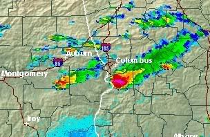
There is a strong couplet with the cell in Chattahoochee County in southwest Georgia. A tornado warning is in effect for this cell.

TORNADO WARNING
GAC053-215-120030-
/O.NEW.KFFC.TO.W.0044.070411T2335Z-070412T0030Z/

BULLETIN - EAS ACTIVATION REQUESTED
TORNADO WARNING
NATIONAL WEATHER SERVICE PEACHTREE CITY GA
735 PM EDT WED APR 11 2007

THE NATIONAL WEATHER SERVICE IN PEACHTREE CITY HAS ISSUED A

* TORNADO WARNING FOR...
CHATTAHOOCHEE COUNTY IN WEST CENTRAL GEORGIA
SOUTHERN MUSCOGEE COUNTY IN WEST CENTRAL GEORGIA

* UNTIL 830 PM EDT

* AT 733 PM EDT...NATIONAL WEATHER SERVICE DOPPLER RADAR INDICATED
A SEVERE THUNDERSTORM CAPABLE OF PRODUCING A TORNADO 5 MILES WEST
OF FORT BENNING...MOVING EAST AT 40 MPH.

* OTHER LOCATIONS IN THE WARNING INCLUDE BUT ARE NOT LIMITED TO
CUSSETA AND MANTA.

WHEN A TORNADO WARNING IS ISSUED BASED ON DOPPLER RADAR...IT MEANS
THAT STRONG ROTATION HAS BEEN DETECTED IN THE STORM. A TORNADO MAY
ALREADY BE ON THE GROUND...OR IS EXPECTED TO DEVELOP SHORTLY. IF YOU
ARE IN THE PATH OF THIS DANGEROUS STORM...MOVE INDOORS AND TO A
BASEMENT OR INTERIOR ROOM ON THE GROUND FLOOR. STAY AWAY FROM
WINDOWS. IF DRIVING...DO NOT SEEK SHELTER UNDER A HIGHWAY OVERPASS.

IN ADDITION TO THE TORNADO...THIS STORM IS CAPABLE OF PRODUCING
BASEBALL SIZED HAIL AND DESTRUCTIVE STRAIGHT LINE WINDS.

IF YOU SEE WIND DAMAGE...LARGE HAIL OR SIGNIFICANT FLOODING...WAIT
UNTIL AFTER THE STORM HAS PASSED...AND THEN CALL THE NATIONAL WEATHER
SERVICE TOLL FREE AT 1 8 6 6 7 6 3 4 4 6 6.

LAT...LON 3246 8498 3237 8496 3234 8500 3227 8489
3223 8491 3223 8465 3245 8465

$$

http://www.srh.weather.gov/bmx/
0 likes   

User avatar
tbstorm
Tropical Storm
Tropical Storm
Posts: 135
Joined: Sun Oct 09, 2005 7:33 pm
Location: St. Petersburg, FL

#6 Postby tbstorm » Wed Apr 11, 2007 7:23 pm

Yeah looks like a real NASTY cell south of Columbus

Image

On the loops, it looks like its moving a little right of the mean flow as well.
0 likes   


Return to “USA & Caribbean Weather”

Who is online

Users browsing this forum: snownado and 24 guests