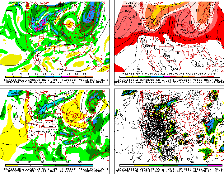
http://cheget.msrc.sunysb.edu/loop/36km.slp.html
MESOETA - 24hr and 33hr
http://www.atmos.albany.edu/gopher-loca ... a06F24.gif
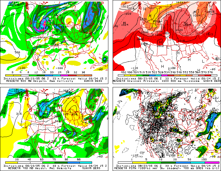
http://www.atmos.albany.edu/gopher-loca ... a06F33.gif
Pretty much all the guidance are in agreement with a very deep NEG TILTed Bombing of this low with the MM5's solution the strongest (and deepest).
Severe weather looking more likely from the Carolinas northward into Southern Pennsylvania today.
New 00z MM5 run even DEEPER at 968 MB
Moderator: S2k Moderators
Forum rules

The posts in this forum are NOT official forecast and should not be used as such. They are just the opinion of the poster and may or may not be backed by sound meteorological data. They are NOT endorsed by any professional institution or STORM2K.
-
Stormsfury

- Category 5

- Posts: 10549
- Age: 53
- Joined: Wed Feb 05, 2003 6:27 pm
- Location: Summerville, SC

-
stormraiser
- Category 5
- Posts: 3453
- Age: 55
- Joined: Sun Oct 27, 2002 4:11 pm
- Location: Southern Maryland
- Contact:
I don't hope for major damage. I do however hope that one of the trees out in front of my house falls on my phone line. Verizon won't change my antiquated lines unless they are cut or damaged somehow. My internet connection maxes out at 26.4Kbps. SLLLLLLLLLLOOOOOOOOOOOOOWWWWWWWWWWW!!!!!!!!!!!!!!!!
This could be my lucky day. :o
This could be my lucky day. :o
0 likes
-
Scott_inVA

- Storm2k Forecaster

- Posts: 1238
- Joined: Sat Oct 12, 2002 5:44 pm
- Location: Lexington, Virginia
- Contact:
Re: New 00z MM5 run even DEEPER at 968 MB
Stormsfury wrote:http://cheget.msrc.sunysb.edu/loop/36km.slp.html
MESOETA - 24hr and 33hr
http://www.atmos.albany.edu/gopher-loca ... a06F24.gif
http://www.atmos.albany.edu/gopher-loca ... a06F33.gif
Pretty much all the guidance are in agreement with a very deep NEG TILTed Bombing of this low with the MM5's solution the strongest (and deepest).
Severe weather looking more likely from the Carolinas northward into Southern Pennsylvania today.
Check out the helicity over Upstate NY. GeezLouise :o
OVC for much of the Mid-Atlantic so I'm banking on a diminished TOR threat (except Ohio/w PA and WV) but Eta's 200mb puts western VA/NC under right entrance so some SVR does seem likely.
MAN! I wish it was April!!!!!!!!!!!!!!!!
Scott
0 likes

Re: New 00z MM5 run even DEEPER at 968 MB
Check out the helicity over Upstate NY. GeezLouise :o
I'm not sure what this means but it sounds bad
0 likes
-
Stephanie

- S2K Supporter

- Posts: 23843
- Age: 63
- Joined: Thu Feb 06, 2003 9:53 am
- Location: Glassboro, NJ
Here's the outlook for Southern New Jersey... :o
Severe Weather Alert from the National Weather Service
...SEVERE WEATHER OUTLOOK... CORRECTED NATIONAL WEATHER SERVICE MOUNT HOLLY NJ 1201 PM EDT TUE OCT 14 2003
... DAMAGING WINDS AND HEAVY RAIN POSSIBLE FROM LATE THIS EVENING INTO THE EARLY MORNING HOURS OF WEDNESDAY...
THE POTENTIAL EXISTS LATE THIS EVENING AND OVERNIGHT FOR SEVERE THUNDERSTORMS TO DEVELOP ESPECIALLY OVER PARTS OF MARYLAND, ALL OF DELAWARE, SOUTHERN NEW JERSEY AND SOUTHEASTERN PENNSYLVANIA. HOWEVER, OTHER AREAS MAY ALSO EXPERIENCE DAMAGING WINDS CARRIED TO THE GROUND FROM HEAVY SHOWERS NOT ASSOCIATED WITH THUNDERSTORMS.
LOW PRESSURE WILL CONTINUE TO RAPIDLY DEVELOP OVER THE OHIO VALLEY THIS AFTERNOON AND WILL RACE INTO EASTERN CANADA OVERNIGHT. ITS ASSOCIATED COLD FRONT WILL REACH THE COAST LATER TONIGHT.
AHEAD OF AND WITH THE COLD FRONT, STRONG GUSTY WINDS AND SOME HEAVY RAIN, AND EVEN A FEW THUNDERSTORMS, ARE LIKELY TO PASS THROUGH THE REGION. WITH THE STRONG GUSTY WINDS ACCOMPANYING THE FRONT, THE DOWNING OF SOME TREES, ALONG WITH SCATTERED POWER OUTAGES, IS POSSIBLE ACROSS PORTIONS OF THE REGION. IN CASES LIKE THIS, THE STRONG DAMAGING WINDS USUALLY OCCUR SHORTLY AFTER THE ONSET OF HEAVY RAIN.
AREA RESIDENTS SHOULD BE AWARE THAT THESE POTENT COLD FRONTS IN THE AUTUMN AND SPRING TRANSITION SEASONS OFTEN PRODUCE LOCALLY STRONG OR SPOTTY SEVERE WEATHER.
BEHIND THE FRONT, GUSTY WINDS FROM THE WEST AND NORTHWEST ARE EXPECTED ON WEDNESDAY AS THE LOW INTENSIFIES OVER EASTERN CANADA. AT THIS TIME, WINDS ARE ANTICIPATED TO BE SUSTAINED AROUND 30 MPH, WITH GUSTS REACHING NEAR 50 MPH. DUE TO THE SUSTAINED WINDS EXPECTED, A HIGH WIND ADVISORY MAY BE ISSUED LATER TODAY FOR WEDNESDAY.
HEAVY RAIN IS LIKELY FOR MOST AREAS WITH SOME ISOLATED 2 TO 3 INCHES BY WEDNESDAY MORNING. THIS WILL CAUSE PONDING ON SOME ROADWAYS AND SMALLER STREAMS AND CREEKS WILL BE MONITORED FOR THE POTENTIAL FOR RAPID RISES AND POSSIBLE FLOODING....
Well, we haven't had a good thunderstorm in awhile!!!!
0 likes

Return to “USA & Caribbean Weather”
Who is online
Users browsing this forum: No registered users and 101 guests