

The mid to upper warmth in the atmosphere has been relentless, all layers really, reflecting at the surface de facto when it isn't raining. Essentially a cold season heat wave up there for months on end.


Moderator: S2k Moderators


rwfromkansas wrote:Hopefully we see some good storms tomorrow to wrap things up. Want another good rain since it looks dry the rest of the month.
Hoping some cap action can break before the main line.

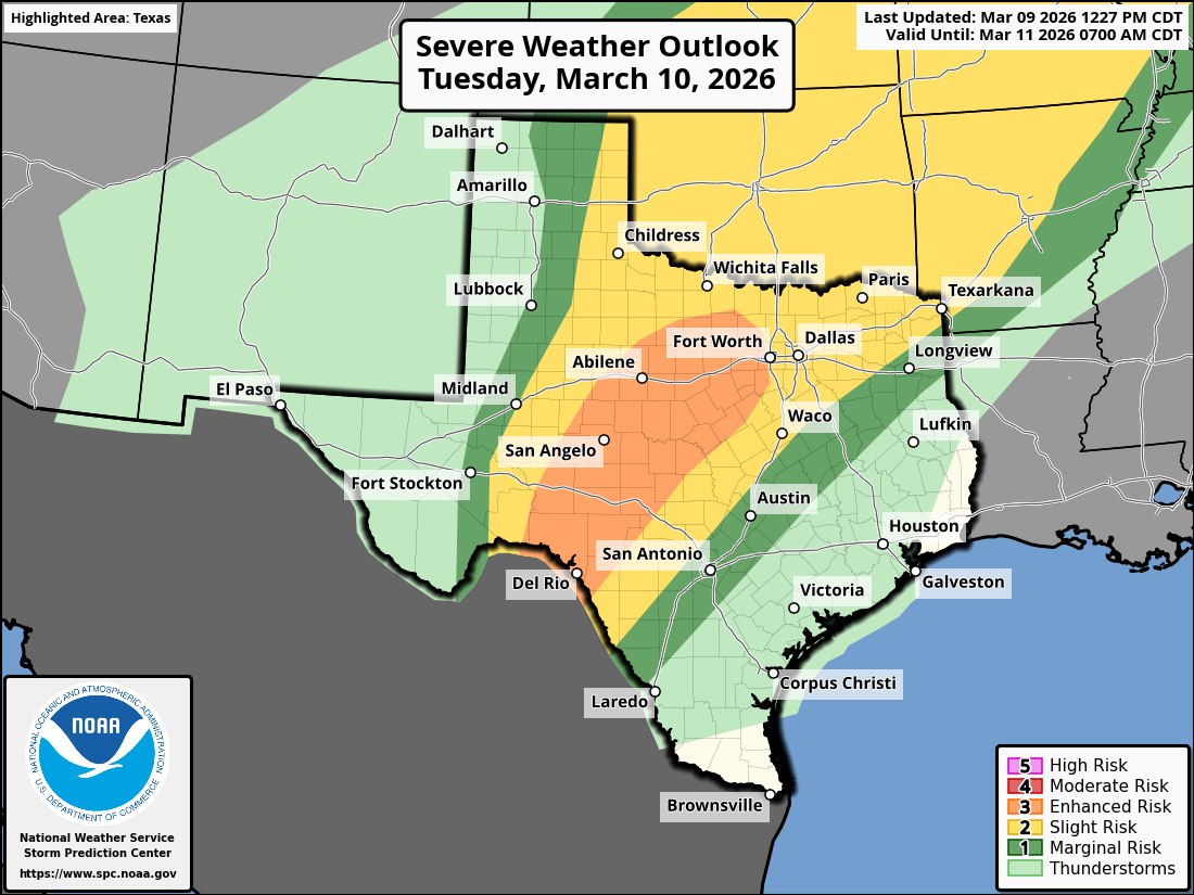
Day 2 Convective Outlook
NWS Storm Prediction Center Norman OK
1227 PM CDT Mon Mar 09 2026
Valid 101200Z - 111200Z
...THERE IS AN ENHANCED RISK OF SEVERE THUNDERSTORMS ACROSS CENTRAL
ILLINOIS INTO NORTHWEST INDIANA AND ACROSS THE EDWARDS PLATEAU INTO
CENTRAL TEXAS...
...SUMMARY...
Scattered severe thunderstorms are forecast on Tuesday from the
southern Plains into the southern Great Lakes vicinity. All severe
hazards are possible.
...Synopsis...
A bi-modal severe weather event is expected Tuesday afternoon and
evening across the Mid-West and portions of central Texas.
Mid-morning surface observations/analyses reveal a surface low
migrating eastward across the upper Great Lakes with a trailing cold
front draped southwestward into the central Plains. Weakening winds
behind the front suggest that this boundary will begin to stall
later today across the Midwest/central Plains. Meanwhile, returning
moisture is forecast to spread north over the next 24 hours as
surface pressure falls and southerly winds increase across the
Plains with the approach of the upper trough currently meandering
over Baja California and a slight amplification of the upper wave
over the north-central CONUS. This will help establish an expansive
warm sector from southern Texas northward into the central Plains
and Great Lakes region, bounded to the north by the stalled frontal
boundary and to the west by a weak dryline/Pacific front. Strong to
severe thunderstorms are expected within this warm sector as ascent
along the Midwest frontal zone and across the southern Plains
increases with the ejection of the upper trough late Tuesday
afternoon into Tuesday night. Southern Plains...
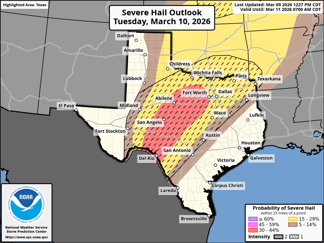
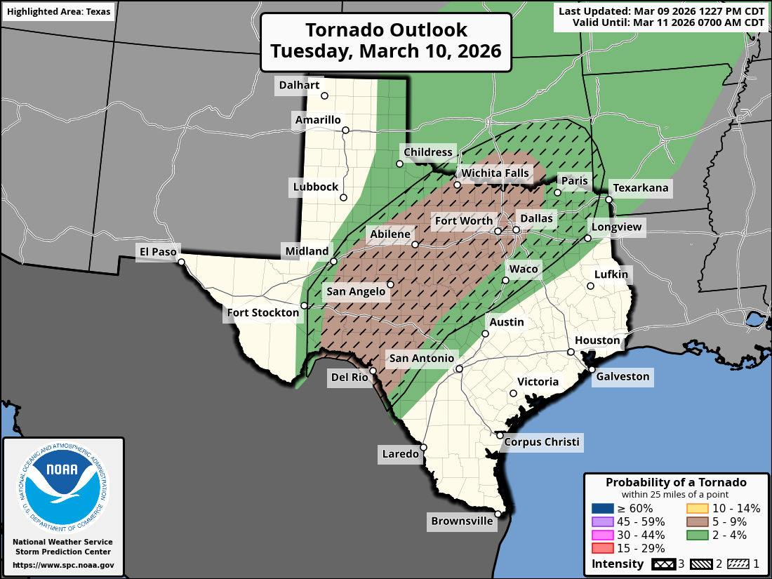
12 UTC soundings across the southern Plains sampled steep mid-level
lapse rates already in place across the region. The onset of deep
moisture return is noted along the TX Coastal Plain, which should
spread north across central TX into OK by Tuesday morning.
Isentropic ascent within the warm sector may support isolated
thunderstorm development by late morning across north TX into the
Texarkana region where capping should be weaker. By late
afternoon/early evening, more widespread thunderstorm development is
expected across central TX as strong height falls associated with
the ejecting upper wave overspread the region. Initially discrete
supercells will be capable of all hazards, through very large (2+
inch) hail appears to be the most probable threat. Strong forcing
for ascent will promote upscale growth through the evening with one
or more bowing segments possible. Enlarging low-level hodographs
associated with an increasing nocturnal jet may support embedded
circulations within the developing squall line. 30% hail/wind
probabilities were introduced to highlight the corridor of higher
hail/wind threat from the Edwards Plateau into central TX.


Stratton23 wrote:Hopefully el nino will inhibit the death ridge from showing up much in the summer, im not sure i can take another summer here with a massive heat ridge sitting right over texas for weeks on end
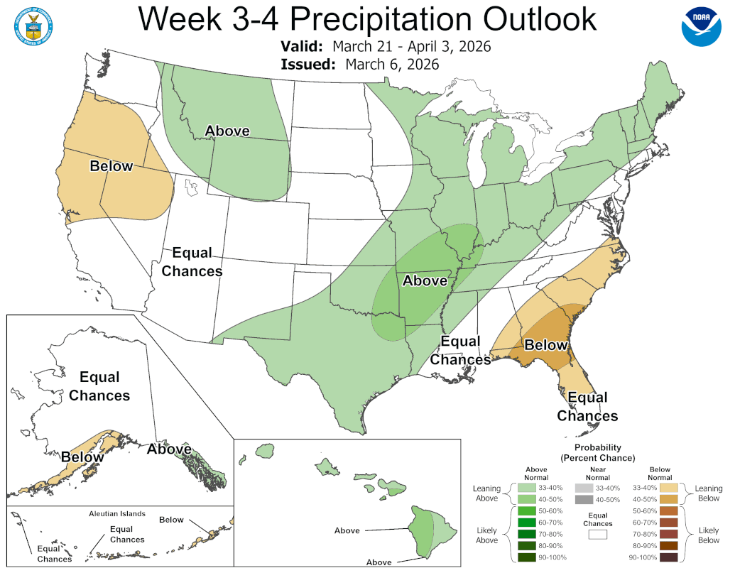
Stratton23 wrote:eh i dont see it, CPC keeps it dry through the last week of march, too much western US ridging keeps systems to our east, i think sometime in april is when things truely start to change, I. was never convinced that this “ wet weather “ this weekend was the real change, give it a couple weeks and i think things may start to ramp up more
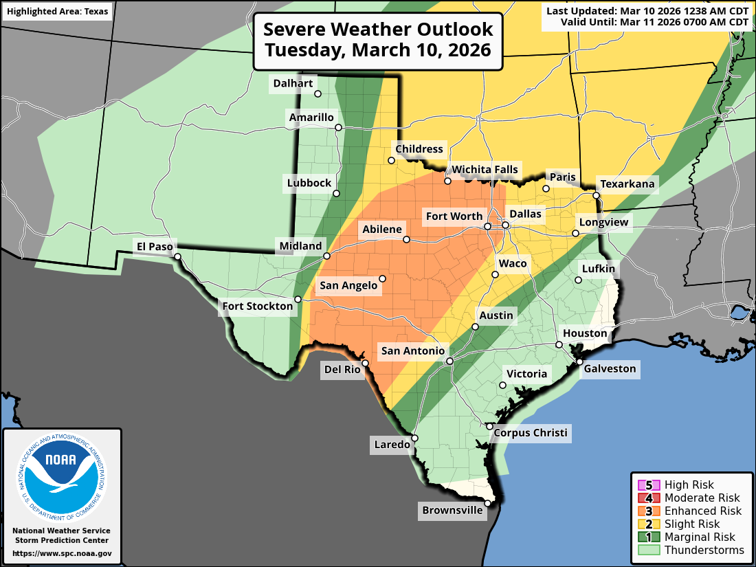
...Southern Plains...
Strong upper low is clearly evident on water-vapor imagery over the
central Baja Peninsula early this morning. This low is ejecting
east-northeast in line with latest model guidance and should advance
into north central Mexico by 18z, then into far west TX by early
evening as it begins to open up. Strong boundary layer heating will
be noted across northeast Mexico, north along the TX/NM border into
western KS. As a result, steep 0-3km lapse rates will develop ahead
of the approaching trough. Leading edge of large-scale ascent should
overspread the dry line around 21z and supercells should quickly
evolve as midlevel temperatures will cool quickly immediately ahead
of the trough. Very large hail is possible with initial supercell
development before strong forcing encourages a more linear evolution
and possible elongated MCS. Strong winds may accompany this squall
line.
Latest model guidance also suggests a weak disturbance may eject
well ahead of the primary low into south central TX. Deep convection
is possible ahead of this feature, but the primary concern will be
some hail and gusts.
..Darrow/Lyons.. 03/10/2026


HockeyTx82 wrote:12HRRR looks like moring mid day stuff South and East of DFW then a line blows in to DFW later on overnight?
I'm guessing that means more of a wind and hail threat for DFW and maybe some spin ups along the line?
Ntxw wrote:HockeyTx82 wrote:12HRRR looks like moring mid day stuff South and East of DFW then a line blows in to DFW later on overnight?
I'm guessing that means more of a wind and hail threat for DFW and maybe some spin ups along the line?
Yes sounds about right. Mostly an overnight event for us with a line. Enhanced likely more for confidence of coverage.
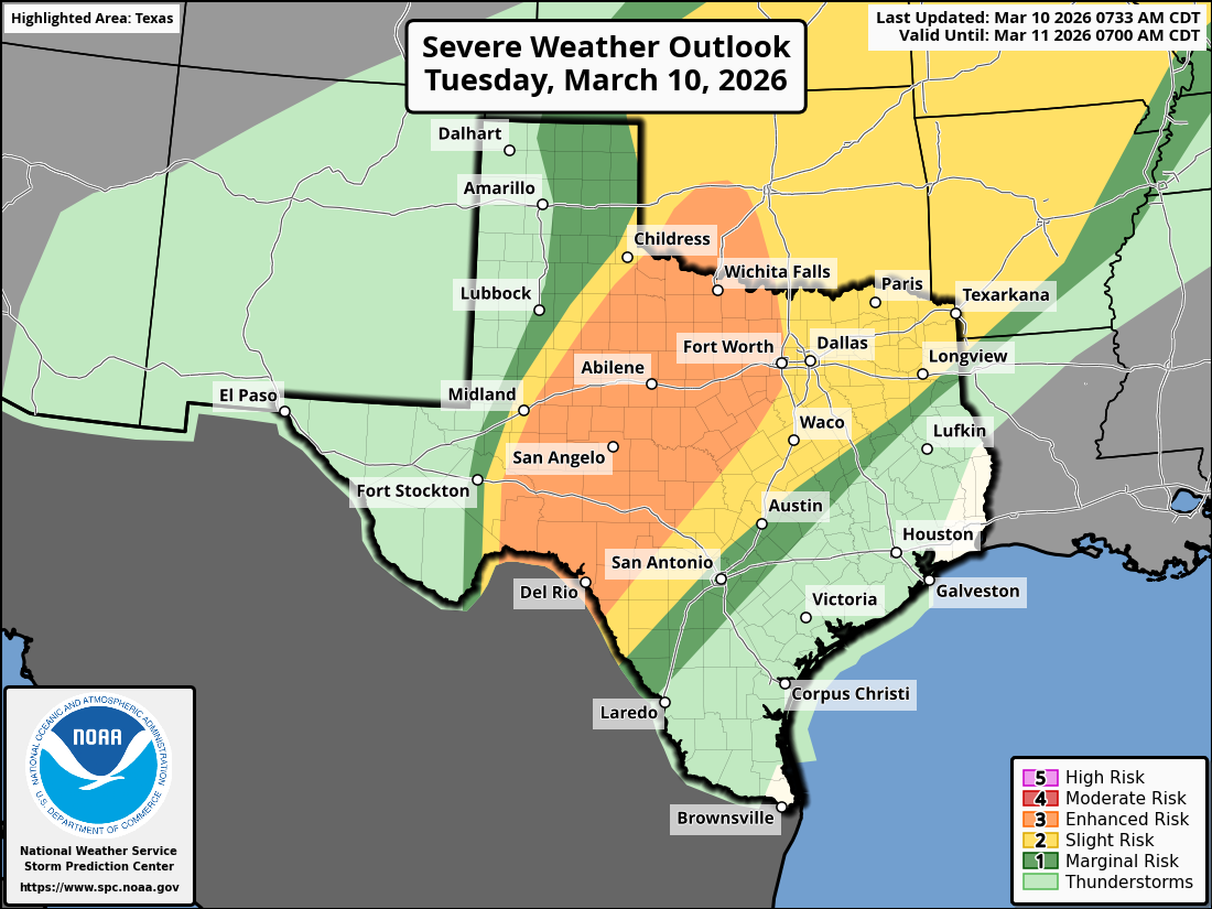
Day 1 Convective Outlook
NWS Storm Prediction Center Norman OK
0733 AM CDT Tue Mar 10 2026
Valid 101300Z - 111200Z
...THERE IS AN ENHANCED RISK OF SEVERE THUNDERSTORMS FROM THE MID
MISSISSIPPI VALLEY INTO THE SOUTHERN GREAT LAKES...AND FROM WEST
TEXAS INTO SOUTHWEST OKLAHOMA...
...SUMMARY...
Severe thunderstorms are forecast today from the southern Plains
into the southern Great Lakes vicinity. All severe hazards are
possible, including the risk for a few strong to intense tornadoes
and very large hail.
...Synopsis...
A split-flow upper pattern persists across the CONUS this morning.
Early-morning satellite imagery shows a well-defined upper low over
the central Baja Peninsula within the southern stream and a subtle,
low-amplitude shortwave trough moving through the Pacific Northwest
within the northern stream. Surface analysis shows a large reservoir
of low-level moisture from the southern Plains and Lower MS Valley
northeastward into the southern Great Lakes. General expectation is
for both the southern-stream upper low and northern-stream shortwave
to progress eastward today, as some modest phasing occurs between
these two features.
This evolution will contribute to strengthening mid-level flow
across much of the Plains and MS Valley, while also resulting in
increased ascent across the broad warm sector. This will result in a
large area of strong to severe thunderstorms from the southern
Plains into the southern Great Lakes, beginning during the early
afternoon and persisting through the evening and overnight. Two
areas within this broader region, west TX into southwest OK and the
Mid MS Valley into the southern Great Lakes, have environmental
conditions that support the potential for significant severe
weather, including very large hail greater than 2" in diameter and
strong to intense tornadoes.
Southern Plains...
The southern-stream upper low is forecast to eject eastward across
northern Mexico today, with ascent preceding this low overspreading
a West TX dryline by the afternoon. Initial storm development is
anticipated over the Permian Basin/Big Bend vicinity, with moderate
buoyancy and very strong vertical shear supporting a quick evolution
into supercells capable of very large hail greater than 3" in
diameter. Increasing thunderstorm coverage is expected from
southwest TX into southwest OK as the upper low continues eastward.
Very large hail will remain the primary severe risk although a trend
towards a more linear mode is expected throughout the evening.
Strong gusts could accompany the resulting squall line. The tornado
risk is expected to remain low, owing primarily to the modest
low-level flow. This low-level flow is expected to increase across
the TX Hill Country tonight, where a relatively greater tornado risk
could materialize if cells remain discrete.
Return to “USA & Caribbean Weather”
Users browsing this forum: TeamPlayersBlue, wxman22 and 162 guests

