
severe wx update
Good evening folks. A busy night across the central United States tonight with a combination of both a winter storm across the central plains and midwestern US and a severe weather episode along the Gulf coastal states. More on the winter storm angle of this in the winter wx forum.
Severe weather is the story tonight and threat of damaging winds, hail, and isolated tornadoes from southeast Texas into southern Louisiana. There are even a few severe thunderstorm warnings in southern Louisiana tonight as a complex of severe thunderstorms approaches from the Gulf Of Mexico. The main threat with these will be large hail and damaging winds. As of 7 PM, severe thunderstorm warnings are up for St Marys and Cameron Parishes in Louisiana. The biggest threat is very large and destructive hail. However damaging winds are possible as well.
No other warnings are up at this time. However many flood watches are up due to the anticipation of very heavy rain from eastern and southeastern and central Texas east and northeastward through Louisiana and portions of Arkansas as well. 3-5 inches of rain remains possible in these places, which would cause flooding. Do not drive through flooded roads. The leading cause of deaths in flash floods is driving vehicles through flooded roads. What's gonna win out, water that weighs 60 pounds a cubic foot, or a vehicle???? I think you can figure that one out. It's easy to say it's gonna be a dangerous night tonight. Keep an eye on this.
Severe threat does continue tomorrow along the central gulf coast from Louisiana into Mississippi and possibly Alabama later in the day. Damaging winds are the primary threat and possibly an isolated tornado. A slight rish exists on Friday as well for the eastern Carolinas down into northern Florida.
More updates on the severe weather side of this later tonight.
Jim
Jim
severe wx threat
Moderator: S2k Moderators
Forum rules

The posts in this forum are NOT official forecast and should not be used as such. They are just the opinion of the poster and may or may not be backed by sound meteorological data. They are NOT endorsed by any professional institution or STORM2K.
severe wx threat
0 likes
Yup
Potential is there for damaging winds and a few tornadoes with that slight risk area. The main thing we should focus on is a possible squall line moving into north central Florida during the day Friday. This will be associated with the main cold front.
Jim
Jim
0 likes
-
ColdFront77
Wonderful. I am looking forward to this potential event. 
Yes indeed, this will be with the "main" cold front.
---------------------------------------------------------------------------------------------------------------
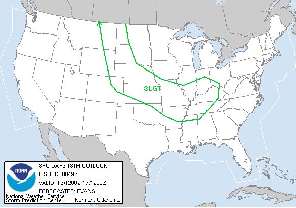
Text Product from the National Weather Service Storm Prediction Center in Norman,
Oklahoma, that goes with the above graphic:
DAY 3 CONVECTIVE OUTLOOK RESENT 1
NWS STORM PREDICTION CENTER NORMAN OK
0553 AM CST WED FEB 04 2004
VALID 061200Z - 071200Z
...THERE IS A SLGT RISK OF SVR TSTMS FOR THE SOUTHEASTERN U.S....
...SOUTHEAST INTO THE MID ATLANTIC...
A SERIES OF FAST MOVING SHORTWAVE TROUGHS WILL ROTATE AROUND CENTRAL
U.S. MID/UPPER LEVEL TROUGH AND SHIFT THE MEAN TROUGH AXIS EWD
ACROSS THE GREAT LAKES/MS RIVER VALLEY FRIDAY. STRONG SHORTWAVE
TROUGH IS FORECAST TO EJECT NEWD FROM BASE OF TROUGH OVER TX EARLY
IN THE PERIOD AND MOVE INTO THE MID ATLANTIC REGION BY EARLY
SATURDAY MORNING. AHEAD OF THE BROAD UPPER TROUGH AXIS...A STRONG
SURFACE COLD FRONT WILL EXTEND ALONG THE APPALACHIANS FRIDAY MORNING
AND SHOULD MOVE ALONG A MID/SRN ATLANTIC COAST - NRN FL LINE BY
FRIDAY EVENING...BEFORE MOVING ACROSS ALL BUT SRN FL FRIDAY NIGHT.
BOTH GFS AND ETA SUGGEST SURFACE WAVE/LOW WILL FORM ALONG THIS FRONT
DURING THE AFTERNOON OVER THE CAROLINAS...WITH STRONG SSELY FLOW OFF
THE ATLANTIC DEVELOPING INTO THE MID ATLANTIC REGION.
EXTENSIVE LINEAR MCS/SQUALL LINE EXPECTED AT THE BEGINNING OF THE
PERIOD ALONG AND JUST AHEAD OF APPROACHING COLD FRONT...WHICH WILL
CONTINUE ESEWD ACROSS THIS REGION THROUGH THE PERIOD. LOW AND DEEP
LAYER SHEAR WILL BE QUITE STRONG ACROSS THIS AREA AS H25 WINDS
EXCEED 100 KT AND SSWLY H85 WINDS RANGE FROM 30+ KT OVER FL TO 70+
KT INTO THE MID ATLANTIC. THOUGH MUCAPES WILL NOT EXCEED 1000 J/KG
ACROSS MUCH OF THE REGION...LOW LEVEL MOISTURE IS EXPECTED TO
INCREASE WITH SURFACE DEW POINTS AOA 60F AHEAD OF COLD FRONT FROM
ERN NC INTO FL. IMPRESSIVE SHEAR AND FORECAST OF A N-S ORIENTED
SQUALL LINE MOVING STEADILY EWD INTO A MOISTENING BOUNDARY LAYER
SUGGEST SLIGHT RISK IS WARRANTED FOR FRIDAY INTO FRIDAY NIGHT OVER
MUCH OF THIS REGION...WITH THE POTENTIAL FOR WIND DAMAGE/TORNADOES
ACCOMPANYING ANY SURFACE-BASED CONVECTION.
..EVANS.. 02/04/2004
Yes indeed, this will be with the "main" cold front.
---------------------------------------------------------------------------------------------------------------
Text Product from the National Weather Service Storm Prediction Center in Norman,
Oklahoma, that goes with the above graphic:
DAY 3 CONVECTIVE OUTLOOK RESENT 1
NWS STORM PREDICTION CENTER NORMAN OK
0553 AM CST WED FEB 04 2004
VALID 061200Z - 071200Z
...THERE IS A SLGT RISK OF SVR TSTMS FOR THE SOUTHEASTERN U.S....
...SOUTHEAST INTO THE MID ATLANTIC...
A SERIES OF FAST MOVING SHORTWAVE TROUGHS WILL ROTATE AROUND CENTRAL
U.S. MID/UPPER LEVEL TROUGH AND SHIFT THE MEAN TROUGH AXIS EWD
ACROSS THE GREAT LAKES/MS RIVER VALLEY FRIDAY. STRONG SHORTWAVE
TROUGH IS FORECAST TO EJECT NEWD FROM BASE OF TROUGH OVER TX EARLY
IN THE PERIOD AND MOVE INTO THE MID ATLANTIC REGION BY EARLY
SATURDAY MORNING. AHEAD OF THE BROAD UPPER TROUGH AXIS...A STRONG
SURFACE COLD FRONT WILL EXTEND ALONG THE APPALACHIANS FRIDAY MORNING
AND SHOULD MOVE ALONG A MID/SRN ATLANTIC COAST - NRN FL LINE BY
FRIDAY EVENING...BEFORE MOVING ACROSS ALL BUT SRN FL FRIDAY NIGHT.
BOTH GFS AND ETA SUGGEST SURFACE WAVE/LOW WILL FORM ALONG THIS FRONT
DURING THE AFTERNOON OVER THE CAROLINAS...WITH STRONG SSELY FLOW OFF
THE ATLANTIC DEVELOPING INTO THE MID ATLANTIC REGION.
EXTENSIVE LINEAR MCS/SQUALL LINE EXPECTED AT THE BEGINNING OF THE
PERIOD ALONG AND JUST AHEAD OF APPROACHING COLD FRONT...WHICH WILL
CONTINUE ESEWD ACROSS THIS REGION THROUGH THE PERIOD. LOW AND DEEP
LAYER SHEAR WILL BE QUITE STRONG ACROSS THIS AREA AS H25 WINDS
EXCEED 100 KT AND SSWLY H85 WINDS RANGE FROM 30+ KT OVER FL TO 70+
KT INTO THE MID ATLANTIC. THOUGH MUCAPES WILL NOT EXCEED 1000 J/KG
ACROSS MUCH OF THE REGION...LOW LEVEL MOISTURE IS EXPECTED TO
INCREASE WITH SURFACE DEW POINTS AOA 60F AHEAD OF COLD FRONT FROM
ERN NC INTO FL. IMPRESSIVE SHEAR AND FORECAST OF A N-S ORIENTED
SQUALL LINE MOVING STEADILY EWD INTO A MOISTENING BOUNDARY LAYER
SUGGEST SLIGHT RISK IS WARRANTED FOR FRIDAY INTO FRIDAY NIGHT OVER
MUCH OF THIS REGION...WITH THE POTENTIAL FOR WIND DAMAGE/TORNADOES
ACCOMPANYING ANY SURFACE-BASED CONVECTION.
..EVANS.. 02/04/2004
0 likes
Return to “USA & Caribbean Weather”
Who is online
Users browsing this forum: Brushcountry, Google [Bot] and 52 guests