Alabama Severe Weather

U.S. & Caribbean Weather Discussions and Severe Weather Events

Moderator: S2k Moderators

Forum rules

The posts in this forum are NOT official forecast and should not be used as such. They are just the opinion of the poster and may or may not be backed by sound meteorological data. They are NOT endorsed by any professional institution or STORM2K.

Help Support Storm2K
Message
Author
User avatar
Brett Adair
Category 1
Category 1
Posts: 322
Joined: Sun Apr 11, 2004 8:49 pm
Location: Sylacauga, Alabama
Contact:

Alabama Severe Weather

#1 Postby Brett Adair » Fri Apr 01, 2005 2:42 pm

Thermodynamics are becoming increasingly conducive of severe weather. Currently 75/60 at my location with SSE winds of 21mph. Low level moist advection is ongoing as SFC low pressure has developed across NE MS. N-S oriented squall line is developing in MS along in the right entrance region of a 500 hPa jet streak. As increasing instability fields move across the region and continue to destabalize the area, some supercell formation is definately not out of the question across Central AL.

Image

The 850-500 shear values speak for themselves in saying that we are definately going to enter a tornado producing environment.

That not good enough for ya? Well have a look at 0-1 km SRH fields...

Image

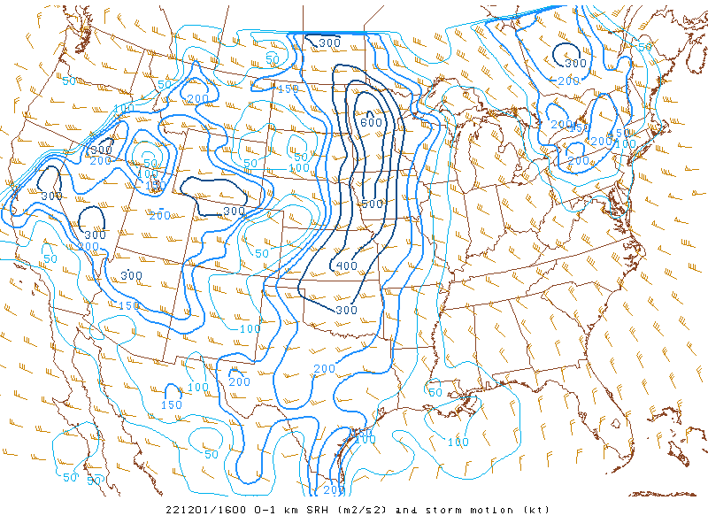
An area of 400+m2/s2 SRH is located directly over my head and it looks as if things will fire as we head into the peak heating hour (3-4pm CDT)

-CG strikes are really increasing across ERN MS with the intensifying squall line. Some embedded supercellular formation can not be ruled out as well as some storms have sustained mesocyclones with definate mid level rotation.

A Severe Thunderstorm Watch is in effect for the region until 6 PM CDT.

Image

Expect this to be upgraded to TOR soon especially across eastern sections if storms can fire.
0 likes   

Brent
S2K Supporter
S2K Supporter
Posts: 38094
Age: 37
Joined: Sun May 16, 2004 10:30 pm
Location: Tulsa Oklahoma
Contact:

#2 Postby Brent » Fri Apr 01, 2005 7:10 pm

Watch has expired and will likely not be re-issued. No supercells just a skinny line. Should clear through here in about 2 hours. Has only been a very few warnings.
0 likes   
#neversummer

User avatar
Brett Adair
Category 1
Category 1
Posts: 322
Joined: Sun Apr 11, 2004 8:49 pm
Location: Sylacauga, Alabama
Contact:

#3 Postby Brett Adair » Sat Apr 02, 2005 11:32 am

Yeah, this morning that I have went back and looked at some things it was very surprising that a thunderstorm watch was even issued. No matter how many parameters you have together, if you have a shallow stable layer near the PBL you can hang it up....and that is what caused us to bite the dust AGAIN yesterday.
0 likes   


Return to “USA & Caribbean Weather”

Who is online

Users browsing this forum: No registered users and 10 guests