Texas Summer - 2014

U.S. & Caribbean Weather Discussions and Severe Weather Events

Moderator: S2k Moderators

Forum rules

The posts in this forum are NOT official forecast and should not be used as such. They are just the opinion of the poster and may or may not be backed by sound meteorological data. They are NOT endorsed by any professional institution or STORM2K.

Help Support Storm2K
Message
Author
User avatar
Portastorm
Storm2k Moderator
Storm2k Moderator
Posts: 9914
Age: 63
Joined: Fri Jul 11, 2003 9:16 am
Location: Round Rock, TX
Contact:

Re: Texas Summer - 2014

#101 Postby Portastorm » Tue Jun 10, 2014 1:12 pm

What a remarkable weather day here in Austin. We had 81 degrees with 45% humidity at 12 noon. On June 10th no less. And, a nice dry breeze blowing in from the northwest!

In 2011 we hit 100 on this date. In 2012, we hit 97. Last year we hit 96. We'll be lucky to hit the forecasted high today of 90.

I'm loving this summer of 2014 weather. :D
0 likes   
Any forecasts under my name are to be taken with a grain of salt. Get your best forecasts from the National Weather Service and National Hurricane Center.

weatherdude1108
Category 5
Category 5
Posts: 4228
Joined: Tue Dec 13, 2011 1:04 pm
Location: Northwest Austin/Cedar Park, TX

Re: Texas Summer - 2014

#102 Postby weatherdude1108 » Tue Jun 10, 2014 1:39 pm

Portastorm wrote:What a remarkable weather day here in Austin. We had 81 degrees with 45% humidity at 12 noon. On June 10th no less. And, a nice dry breeze blowing in from the northwest!

In 2011 we hit 100 on this date. In 2012, we hit 97. Last year we hit 96. We'll be lucky to hit the forecasted high today of 90.

I'm loving this summer of 2014 weather. :D

It is beautiful out there! Feels great, and green everywhere! :ggreen:
0 likes   

aggiecutter
Category 5
Category 5
Posts: 1753
Joined: Thu Oct 14, 2004 9:22 pm
Location: Texarkana

Re: Texas Summer - 2014

#103 Postby aggiecutter » Tue Jun 10, 2014 1:50 pm

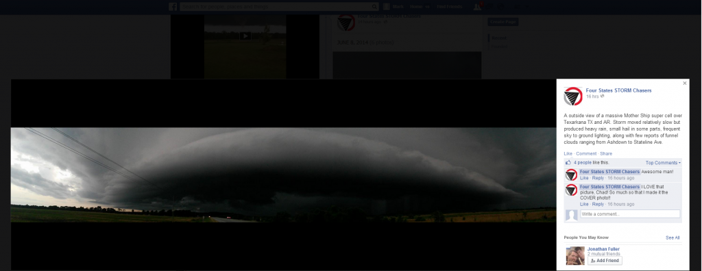
Picture of the super-cell thunderstorm from Four States Storm Chasers that hit the city of Texarkana on Sunday night.

Image
0 likes   

Ralph's Weather
S2K Supporter
S2K Supporter
Posts: 3269
Age: 38
Joined: Fri Dec 13, 2013 11:55 am
Location: Lindale, TX
Contact:

#104 Postby Ralph's Weather » Tue Jun 10, 2014 2:30 pm

Sunny and 81 in Tyler with a nice NW breeze in the middle of the afternoon in June, wow.
0 likes   
Follow on Facebook at Ralph's Weather.

aggiecutter
Category 5
Category 5
Posts: 1753
Joined: Thu Oct 14, 2004 9:22 pm
Location: Texarkana

Re: Texas Summer - 2014

#105 Postby aggiecutter » Tue Jun 10, 2014 3:36 pm

Looks like the rains return to North and Northeast Texas Thursday-Friday:

Image
0 likes   

aggiecutter
Category 5
Category 5
Posts: 1753
Joined: Thu Oct 14, 2004 9:22 pm
Location: Texarkana

Re: Texas Summer - 2014

#106 Postby aggiecutter » Tue Jun 10, 2014 3:39 pm

NBC 6 Todd Warren's Futurecast radar for 10:00pm Thursday:

Image
0 likes   

User avatar
South Texas Storms
Professional-Met
Professional-Met
Posts: 4224
Joined: Thu Jun 24, 2010 12:28 am
Location: Houston, TX

Re: Texas Summer - 2014

#107 Postby South Texas Storms » Tue Jun 10, 2014 3:51 pm

Unfortunately the heat will be returning to central and south Texas tomorrow and Thursday with high temperatures approaching 100 degrees in Austin and San Antonio. Hopefully rain chances will return to our part of the state next week.
0 likes   

weatherdude1108
Category 5
Category 5
Posts: 4228
Joined: Tue Dec 13, 2011 1:04 pm
Location: Northwest Austin/Cedar Park, TX

#108 Postby weatherdude1108 » Tue Jun 10, 2014 11:03 pm

Bob Rose has an encouraging outlook for more rain for central Texas in his Tuesday blog. Bring it! This is the typical June pattern of potential overnight MCS's and maybe even daytime popup scattered thundershowers I remember as a child. Well, I am at least hopeful for it anyway! :cheesy: :wink:
:lightning: :rain:
http://www.lcra.org/water/river-and-wea ... ather.aspx
0 likes   
The preceding post is NOT an official forecast, and should not be used as such. It is only the opinion of the poster and may or may not be backed by sound meteorological data. It is NOT endorsed by any professional institution including storm2k.org. For Official Information please refer to the NHC and NWS products.

User avatar
TheProfessor
Professional-Met
Professional-Met
Posts: 3506
Age: 28
Joined: Tue Dec 03, 2013 10:56 am
Location: Wichita, Kansas

#109 Postby TheProfessor » Wed Jun 11, 2014 9:45 am

Well, I wouldn't mind the 0z GFS coming true, I know the GFS has been spinning up phantom storms, but this last one had a tropical system make landfall around the Corpus Christi area and then turn up toward central Texas and then going over north Texas giving beneficial rainfall.
0 likes   
An alumnus of The Ohio State University.

Your local National Weather Service office is your best source for weather information.

aggiecutter
Category 5
Category 5
Posts: 1753
Joined: Thu Oct 14, 2004 9:22 pm
Location: Texarkana

#110 Postby aggiecutter » Wed Jun 11, 2014 4:22 pm

Are anyother of you North Texas guys going to be affected by this MCS:

NATIONAL WEATHER SERVICE SHREVEPORT LA
305 PM CDT WED JUN 11 2014

.DISCUSSION...
NW FLOW ALOFT HAS BROUGHT MILD JUNE TEMPERATURES AND SUNNY SKIES
TO THE REGION TODAY. HOWEVER...THIS IS A BIT DECEPTIVE. A
DISTURBANCE CURRENTLY OVER THE FOUR CORNERS REGION WILL RIDE EWD
AROUND THE NERN PERIPHERY OF THE UPPER RIDGE...AND DOWN ACROSS OUR
REGION THURSDAY INTO FRIDAY. THIS WILL LIKELY SEND AN MCS OUR WAY
THURSDAY AFTERNOON/NIGHT. DAMAGING WINDS...LARGE HAIL...AND
LOCALLY HEAVY RAINFALL WILL BE THE PRIMARY THREATS WITH THESE
STORMS. THE SHORTWAVE WILL FINALLY MOVE E OF THE REGION FRIDAY
MORNING...DIMINISHING RAIN CHANCES BY FRIDAY EVENING.
0 likes   

User avatar
Ntxw
Storm2k Moderator
Storm2k Moderator
Posts: 22783
Joined: Wed Oct 21, 2009 6:34 pm
Location: DFW, Texas

Re:

#111 Postby Ntxw » Wed Jun 11, 2014 6:46 pm

aggiecutter wrote:Are anyother of you North Texas guys going to be affected by this MCS:


Most of North and northern parts of Central Texas will. Those big storms just east of Big Spring is just the first of possibly several clusters/MCS that would move east.
0 likes   
The above post and any post by Ntxw is NOT an official forecast and should not be used as such. It is just the opinion of the poster and may or may not be backed by sound meteorological data. It is NOT endorsed by any professional institution including Storm2k. For official information, please refer to NWS products.

  Help support Storm2K!
Help Support Storm2K

User avatar
Ntxw
Storm2k Moderator
Storm2k Moderator
Posts: 22783
Joined: Wed Oct 21, 2009 6:34 pm
Location: DFW, Texas

Re: Texas Summer - 2014

#112 Postby Ntxw » Wed Jun 11, 2014 7:13 pm

Thing of beauty Hurricane Cristina is, maybe go for major status? Her direct effects won't be felt in Texas but like Amanda she is part of a larger envelope of moisture enhancement from Pacific that has been so persistent. These little disturbances that cross Texas this year have had plentiful rich moisture to work with at many levels of the atmosphere thanks to the EPAC.

Image
0 likes   
The above post and any post by Ntxw is NOT an official forecast and should not be used as such. It is just the opinion of the poster and may or may not be backed by sound meteorological data. It is NOT endorsed by any professional institution including Storm2k. For official information, please refer to NWS products.


  Help support Storm2K!

Help Support Storm2K


User avatar
KatDaddy
Category 5
Category 5
Posts: 2815
Joined: Mon Oct 21, 2002 6:23 pm
Location: League City, Texas

Re: Texas Summer - 2014

#113 Postby KatDaddy » Wed Jun 11, 2014 7:53 pm

A significant severe weather event is possible across N, E, and SE TX tomorrow afternoon into tomorrow night as a short wave moves into NTX. A possible upgrade to moderate risk in later SPC outlooks later tonight. Excerpt from this afternoon's SPC discussion:

POTENTIAL EXISTS FOR SIGNIFICANT SEVERE EVENTS WITH VERY LARGE HAIL AND DAMAGING WIND WITHIN THIS REGION...AND THIS AREA MAY NEED TO BE INCLUDED IN A MODERATE RISK UPGRADE IN DAY 1 UPDATES.
0 likes   
The following post is NOT an official forecast and should not be used as such. It is just the opinion of the poster and may or may not be backed by sound meteorological data. It is NOT endorsed by any professional institution including storm2k.org For Official Information please refer to the NHC and NWS products.

User avatar
Ntxw
Storm2k Moderator
Storm2k Moderator
Posts: 22783
Joined: Wed Oct 21, 2009 6:34 pm
Location: DFW, Texas

#114 Postby Ntxw » Thu Jun 12, 2014 7:40 am

Looks good this morning. Be careful this afternoon for some wind and hail, triple point setting up over I-20 and I-35 intersection especially areas along the warm front from there on east.

Image


In other news no cat 5s in the gulf, but a run at cat 5 in the EPAC from Cristina who is now cat 4! She is the earliest second major for this basin and Amanda was the earliest major. Definitely not normal down there.
0 likes   
The above post and any post by Ntxw is NOT an official forecast and should not be used as such. It is just the opinion of the poster and may or may not be backed by sound meteorological data. It is NOT endorsed by any professional institution including Storm2k. For official information, please refer to NWS products.


  Help support Storm2K!

Help Support Storm2K


BrokenGlassRepublicn
Category 1
Category 1
Posts: 481
Joined: Sun Nov 20, 2011 8:07 pm
Location: Richardson, Texas

Re:

#115 Postby BrokenGlassRepublicn » Thu Jun 12, 2014 8:48 am

Ntxw wrote:Looks good this morning. Be careful this afternoon for some wind and hail, triple point setting up over I-20 and I-35 intersection especially areas along the warm front from there on east.

What time frame are we looking at for storm development? It seems the last few weeks that the West Texas storms developed later in the afternoon, more like 6-8 pm, whereas it seems more typical for storms to begin popping in the 4-6 pm window.
0 likes   

User avatar
Ntxw
Storm2k Moderator
Storm2k Moderator
Posts: 22783
Joined: Wed Oct 21, 2009 6:34 pm
Location: DFW, Texas

Re: Re:

#116 Postby Ntxw » Thu Jun 12, 2014 9:29 am

BrokenGlassRepublicn wrote:
Ntxw wrote:Looks good this morning. Be careful this afternoon for some wind and hail, triple point setting up over I-20 and I-35 intersection especially areas along the warm front from there on east.

What time frame are we looking at for storm development? It seems the last few weeks that the West Texas storms developed later in the afternoon, more like 6-8 pm, whereas it seems more typical for storms to begin popping in the 4-6 pm window.


HRRR is showing anywhere between 2-4pm. I'm not too confident on coverage but whatever comes up could be severe.
0 likes   
The above post and any post by Ntxw is NOT an official forecast and should not be used as such. It is just the opinion of the poster and may or may not be backed by sound meteorological data. It is NOT endorsed by any professional institution including Storm2k. For official information, please refer to NWS products.


  Help support Storm2K!

Help Support Storm2K


Ralph's Weather
S2K Supporter
S2K Supporter
Posts: 3269
Age: 38
Joined: Fri Dec 13, 2013 11:55 am
Location: Lindale, TX
Contact:

#117 Postby Ralph's Weather » Thu Jun 12, 2014 9:48 am

The storms are racing into E TX this morning earlier than I expected. My wife has to drive from Henderson to Palestine sometime in the next few hours so hopefully she can make it without hitting the worst of the storms.
0 likes   
Follow on Facebook at Ralph's Weather.

User avatar
South Texas Storms
Professional-Met
Professional-Met
Posts: 4224
Joined: Thu Jun 24, 2010 12:28 am
Location: Houston, TX

Re: Texas Summer - 2014

#118 Postby South Texas Storms » Thu Jun 12, 2014 12:50 pm

Much of central Texas has a chance of severe thunderstorms this afternoon through tonight as hot temperatures help to destabilize the atmosphere ahead of an upper level disturbance. Large hail and damaging winds are the main severe threats, but a tornado can not be ruled out. Please stay weather aware today.

Image

Uploaded with ImageShack.us
0 likes   

User avatar
JDawg512
Category 5
Category 5
Posts: 1075
Age: 45
Joined: Mon Aug 26, 2013 8:56 pm
Location: Austin
Contact:

Re: Texas Summer - 2014

#119 Postby JDawg512 » Thu Jun 12, 2014 5:30 pm

Tornado Watch was issued at 4 p.m. for Central/West Texas that includes both the Austin and San Antonio areas.
0 likes   
Resident Rain Miser

I am a weather hobbyist living 3.5 miles south of Downtown Austin and in no way or fashion should anything I say concerning forecasts be taken seriously. Please check your local NWS for accurate weather forecasting and conditions.

User avatar
South Texas Storms
Professional-Met
Professional-Met
Posts: 4224
Joined: Thu Jun 24, 2010 12:28 am
Location: Houston, TX

Re: Texas Summer - 2014

#120 Postby South Texas Storms » Thu Jun 12, 2014 6:35 pm

Severe thunderstorms capable of producing tornadoes are currently developing in the Tornado Watch area. These storms could make it to Austin and San Antonio later this evening.

Image

Uploaded with ImageShack.us
0 likes   


Return to “USA & Caribbean Weather”

Who is online

Users browsing this forum: AnnularCane, DallasAg and 14 guests