Major tornado outbreak next Thursday?

U.S. & Caribbean Weather Discussions and Severe Weather Events

Moderator: S2k Moderators

Forum rules

The posts in this forum are NOT official forecast and should not be used as such. They are just the opinion of the poster and may or may not be backed by sound meteorological data. They are NOT endorsed by any professional institution or STORM2K.

Help Support Storm2K
Message
Author
CrazyC83
Professional-Met
Professional-Met
Posts: 34002
Joined: Tue Mar 07, 2006 11:57 pm
Location: Deep South, for the first time!

#101 Postby CrazyC83 » Wed Apr 05, 2006 12:07 pm

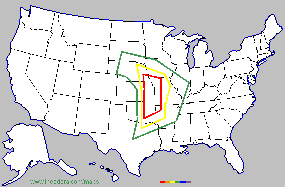
WaitingForSiren wrote:Crazy, I think your map for tomorrow is actually pretty good overall. Usuaully i think they are a little too big and vague, but I think tomorrow could be a widespread devastating outbreak.


Thanks; I am slightly to the east of the SPC in the thought that it could be long-lasting well into the night...
0 likes   

6SpeedTA95
Category 5
Category 5
Posts: 1206
Joined: Wed Oct 19, 2005 3:25 pm
Location: Oklahoma
Contact:

#102 Postby 6SpeedTA95 » Wed Apr 05, 2006 2:58 pm

Anyone have any ideas what time this is gonna kickoff tomorrow? Hopefully it doesn't start east of I35 and hopefully its after 4pm...I've gotta road trip to take tomorrow to ft smith arkansas and probably wont get outta there till close to 1:30 or 2.

From what I'm looking at it looks like things might begin to pop right over I35 sometime between 3 and 4pm which should put me in the clear, does this gel with others too?
0 likes   

Matt-hurricanewatcher

#103 Postby Matt-hurricanewatcher » Wed Apr 05, 2006 3:21 pm

The 12z gfs is discounted as far as I can see. Lets wait intill the 18 and 00z runs. I see a major tornadoe outbeak tomarrow!!!
0 likes   

Matt-hurricanewatcher

#104 Postby Matt-hurricanewatcher » Wed Apr 05, 2006 3:27 pm

Holy sh#$ the nam has came in with 977 milibars. :eek:
0 likes   

User avatar
SouthFloridawx
S2K Supporter
S2K Supporter
Posts: 8346
Age: 46
Joined: Tue Jul 26, 2005 1:16 am
Location: Sarasota, FL
Contact:

#105 Postby SouthFloridawx » Wed Apr 05, 2006 3:32 pm

Image
0 likes   

6SpeedTA95
Category 5
Category 5
Posts: 1206
Joined: Wed Oct 19, 2005 3:25 pm
Location: Oklahoma
Contact:

#106 Postby 6SpeedTA95 » Wed Apr 05, 2006 4:02 pm

SouthFloridawx wrote:Image


I just wonder if the models dont have it a bit too far east, at least I'm hoping :)
0 likes   

6SpeedTA95
Category 5
Category 5
Posts: 1206
Joined: Wed Oct 19, 2005 3:25 pm
Location: Oklahoma
Contact:

#107 Postby 6SpeedTA95 » Wed Apr 05, 2006 4:10 pm

My map for tomorrow

**NOT AN OFFICIAL FORCAST**
Image

Green = slight
Yellow = MDT
Red = High
Purple = Extreme

I dunno that the SPC will put a high chance at svr weather on the map tomorrow but I could see it happening based on the fact that the dewpoints are running about 12 to 15hrs ahead of forcast. Depending on daytime heating tomorrow we could be in for some rough weather. I do think the models have it pushing east a bit fast.
0 likes   

User avatar
NWIASpotter
Category 5
Category 5
Posts: 1961
Joined: Sun Jul 18, 2004 12:58 pm
Location: Terril, Iowa & Ames, Iowa
Contact:

#108 Postby NWIASpotter » Wed Apr 05, 2006 6:00 pm

Remember that we will have to put up with mixing tomorrow, so those dewpoints will be running lower than what they will appear to be tomorrow morning. I think if we can have low 60 Td's in the NE/IA area by tomorrow morning then we should be just fine, if we are still running the in the 50s then we could have issues... Hard to say though.
0 likes   

CrazyC83
Professional-Met
Professional-Met
Posts: 34002
Joined: Tue Mar 07, 2006 11:57 pm
Location: Deep South, for the first time!

#109 Postby CrazyC83 » Wed Apr 05, 2006 7:04 pm

Here are the chances of various types of event from tomorrow through Saturday - NOT AN OFFICIAL FORECAST, just my prediction:

Any severe weather outbreak - 90%
Tornado outbreak - 70%
Major tornado outbreak - 60%
Legendary tornado outbreak - 40%
Record tornado outbreak - 10%

Major outbreak: >25 tornadoes + a killer, or >50 tornadoes
Legendary outbreak: >50 tornadoes + an F5 or major killer, or >100 tornadoes
Record outbreak: >150 tornadoes + 7 or more F5's
0 likes   

User avatar
cheezyWXguy
Category 5
Category 5
Posts: 6108
Joined: Mon Feb 13, 2006 12:29 am
Location: Dallas, TX

#110 Postby cheezyWXguy » Wed Apr 05, 2006 7:17 pm

I see a major to legendary outbreak...record doesnt seem likely at all( altho possible, I'd say 5-15%)
0 likes   

jkt21787
Category 5
Category 5
Posts: 2061
Joined: Tue Aug 31, 2004 5:27 pm
Location: Memphis, TN

#111 Postby jkt21787 » Wed Apr 05, 2006 7:23 pm

Using your critiera, here are my guesses...

Any Severe Weather Outbreak...90%
Tornado Outbreak...60%
Major Tornado Outbreak...40%
Legendary Tornado Outbreak...25%
Record Tornado Outbreak...Less than 1%
0 likes   

User avatar
Gorky
Category 1
Category 1
Posts: 334
Joined: Tue Nov 02, 2004 7:23 am
Location: Scarborough, North Yorkshire, UK

#112 Postby Gorky » Wed Apr 05, 2006 7:41 pm

Whilst I think it's likely we have a tornado outbreak, I wouldn't be overly surprised if this just ends up as a moderate tornado day with more hail and wind reports than anything else. I've seen better days than this before turn out disappointing. Things to note are the storms in the south around OK/AR will be flying with some very fast motions, and storms in the north may start off relatively high based dimishing tornado threat until later. I think the best chacne for severe tornados exists around the southern portion of the watch area, but I certainly wouldn't want to be chasing those.. I think 60mph storm motions aren't out of the question although 40-50 will be more likely.
0 likes   

simplykristi
S2K Supporter
S2K Supporter
Posts: 1220
Joined: Sat May 10, 2003 1:59 pm
Location: Near KCMO
Contact:

#113 Postby simplykristi » Wed Apr 05, 2006 7:43 pm

I am not sure how tomorrow will pan out... But it looks like I am on the west side of the moderate risk for severe weather tomorrow.

Kristi
0 likes   

conestogo_flood
Category 5
Category 5
Posts: 1268
Joined: Wed Sep 28, 2005 5:49 pm

#114 Postby conestogo_flood » Wed Apr 05, 2006 8:18 pm

Is it starting? Severe thunderstorm warnings in Iowa and Missouri, the slight risk now covers that area. Also, severe thunderstorm warnings in north central Texas.
0 likes   

6SpeedTA95
Category 5
Category 5
Posts: 1206
Joined: Wed Oct 19, 2005 3:25 pm
Location: Oklahoma
Contact:

#115 Postby 6SpeedTA95 » Wed Apr 05, 2006 8:39 pm

7 F5's from one system? Ummmm has that EVER happened?
0 likes   

User avatar
Beam
Category 1
Category 1
Posts: 292
Joined: Fri Aug 19, 2005 2:06 pm

#116 Postby Beam » Wed Apr 05, 2006 8:39 pm

It's just a couple of instability storms. The real "fun" begins early tomorrow afternoon.
0 likes   

jkt21787
Category 5
Category 5
Posts: 2061
Joined: Tue Aug 31, 2004 5:27 pm
Location: Memphis, TN

#117 Postby jkt21787 » Wed Apr 05, 2006 8:41 pm

6SpeedTA95 wrote:7 F5's from one system? Ummmm has that EVER happened?
Yeah, the Super Outbreak April 3-4, 1974. Don't know the exact number (it may have been 7) but I know it was at least that.

That is why the comparions of this outbreak and any to that one are, in a word, outlandish.
0 likes   

Matt-hurricanewatcher

#118 Postby Matt-hurricanewatcher » Wed Apr 05, 2006 8:50 pm

Heres mine...


Any severe weather outbreak - 95%
Tornado outbreak - 80%
Major tornado outbreak - 75%
Legendary tornado outbreak - 60%
Record tornado outbreak - 20%

Major outbreak: >25 tornadoes + a killer, or >50 tornadoes
Legendary outbreak: >50 tornadoes + an F5 or major killer, or >100 tornadoes
Record outbreak: >150 tornadoes + 7 or more F5's
0 likes   

6SpeedTA95
Category 5
Category 5
Posts: 1206
Joined: Wed Oct 19, 2005 3:25 pm
Location: Oklahoma
Contact:

#119 Postby 6SpeedTA95 » Wed Apr 05, 2006 8:56 pm

The system is already over far western kansas looks like things may be a bust in oklahoma tomorrow unless this thing slows up over night.
0 likes   

User avatar
senorpepr
Military Met/Moderator
Posts: 12542
Age: 43
Joined: Fri Aug 22, 2003 9:22 pm
Location: Mackenbach, Germany
Contact:

#120 Postby senorpepr » Wed Apr 05, 2006 9:06 pm

Okay... using the same critieria as above... here's my forecast.

Any severe weather outbreak - 99%
Tornado outbreak - 95%
Major tornado outbreak - 50%
Legendary tornado outbreak - 15%
Record tornado outbreak - <1%
0 likes   


Return to “USA & Caribbean Weather”

Who is online

Users browsing this forum: Google Adsense [Bot] and 20 guests