Florida Weather
Moderator: S2k Moderators
Forum rules
The posts in this forum are NOT official forecast and should not be used as such. They are just the opinion of the poster and may or may not be backed by sound meteorological data. They are NOT endorsed by any professional institution or STORM2K.
- cycloneye
- Admin

- Posts: 149556
- Age: 69
- Joined: Thu Oct 10, 2002 10:54 am
- Location: San Juan, Puerto Rico
Re: Florida Weather
Very impressive blob approaching the west coast of the penninsula.Looks like a rainy/stormy day unfolding.


0 likes
Visit the Caribbean-Central America Weather Thread where you can find at first post web cams,radars
and observations from Caribbean basin members Click Here
and observations from Caribbean basin members Click Here
-
TheStormExpert
Re: Florida Weather
BTW, if this were during the hurricane season could this have possibly became a named storm? Just curious.
0 likes
-
TheStormExpert
Re: Florida Weather
Showers/Storms are now rolling into and forming throughout the southern half of the FL peninsula.


0 likes
-
Stormcenter
- S2K Supporter

- Posts: 6689
- Joined: Wed Sep 03, 2003 11:27 am
- Location: Houston, TX
- cycloneye
- Admin

- Posts: 149556
- Age: 69
- Joined: Thu Oct 10, 2002 10:54 am
- Location: San Juan, Puerto Rico
Re: Florida Weather
Stormcenter wrote:So can someone explain what is causing this? It's not low pressure.
Shortwave trough.From NWS MIami.
A short wave over the eastern Gulf of Mexico will continue to move
eastward and across South Florida this afternoon before moving
into the western Atlantic waters tonight.
0 likes
Visit the Caribbean-Central America Weather Thread where you can find at first post web cams,radars
and observations from Caribbean basin members Click Here
and observations from Caribbean basin members Click Here
Re: Florida Weather
Fairly impressive shortwave disturbance this afternoon indeed, maybe a sign of what's to come this hurricane season.
0 likes
- gatorcane
- S2K Supporter

- Posts: 23708
- Age: 48
- Joined: Sun Mar 13, 2005 3:54 pm
- Location: Boca Raton, FL
Re: Florida Weather
psyclone wrote:tomorrow could get interesting over south florida. the spc has a marginal risk in that area based upon a disturbance in the western gulf propagating eastward. there's been a decent uptick in lightning out there with clusters of storms that are moving in that general direction. I'd be watching tomorrow if I were in the MIA CWA...points north of there may partake as well. these events can sneak up on us and outperform.
Yep very active day here. Torrential rains and a good amount of lightning. Not as bad as last Thu. but still quite impressive indeed for this time of year - very summer-like pattern for sure.
0 likes
-
TheStormExpert
Re: Florida Weather
gatorcane wrote:psyclone wrote:tomorrow could get interesting over south florida. the spc has a marginal risk in that area based upon a disturbance in the western gulf propagating eastward. there's been a decent uptick in lightning out there with clusters of storms that are moving in that general direction. I'd be watching tomorrow if I were in the MIA CWA...points north of there may partake as well. these events can sneak up on us and outperform.
Yep very active day here. Torrential rains and a good amount of lightning. Not as bad as last Thu. but still quite impressive indeed for this time of year - very summer-like pattern for sure.
This has been a very impressive Mesoscale Convective System. Although up here in Palm Beach Gardens the rain has been relatively light and minimal so far today.
0 likes
-
TheStormExpert
Re: Florida Weather
TWC seems to be REALLY overplaying the rainfall predictions. 3-5 inches tonight seems way too high, I'd go with up to an half an inch if we're lucky!


0 likes
- AdamFirst
- S2K Supporter

- Posts: 2490
- Age: 36
- Joined: Thu Aug 14, 2008 10:54 am
- Location: Port Saint Lucie, FL
Re: Florida Weather
That first blowup this afternoon over Dade County was right on top of me, just as I had to walk across campus for my 2 PM class. Streaks of lightning across the sky and huge, wet, drenching rain. No hail here at FIU but there was hail reported in the Redlands and Homestead from another cell that developed to the south,
0 likes
Dolphins Marlins Canes Golden Panthers HEAT
Andrew 1992 - Irene 1999 - Frances 2004 - Jeanne 2004 - Wilma 2005 - Fay 2008 - Isaac 2012 - Matthew 2016 - Irma 2017 - Dorian 2019 - Ian 2022 - Nicole 2022 - Milton 2024
Andrew 1992 - Irene 1999 - Frances 2004 - Jeanne 2004 - Wilma 2005 - Fay 2008 - Isaac 2012 - Matthew 2016 - Irma 2017 - Dorian 2019 - Ian 2022 - Nicole 2022 - Milton 2024
Re: Florida Weather
TheStormExpert wrote::uarrow: WOW!Hope everyone along the FL peninsula is prepared for a rocky/wild afternoon!
BTW, if this were during the hurricane season could this have possibly became a named storm? Just curious.
I believe it would had, if it would had been during the summer and moving slower with no shear above it that this MCS would have had the chance to become tropical in nature.
0 likes
- northjaxpro
- S2K Supporter

- Posts: 8900
- Joined: Mon Sep 27, 2010 11:21 am
- Location: Jacksonville, FL
Re: Florida Weather
Earlier this week on this thread, I touched on the models picking up on a potential substantial cold spell for much of the Eastern CONUS and the global models as of late tonight are in good agreement that a potential record breaking cold spell may be in store by the end of next week, including the Deep South and possibly into Florida...
EURO 216 hour medium range analysis up to next Friday April 8, shows an atypical and very anomalously cold pattern for all of Eastern North America, all the way down to the Gulf Coast and into Florida, with well below temps for this time of the year. This potentially could be an extremely impressive cold snap for early April if EURO and GFS verifies.


Meanwhile, tonight's 0Z GFS run also is on board with the EURO in depicting a very strong upper level trough being carved out across the Eastern CONUS, with the polar vortex positioned just south of Hudson Bay. The base of the deep upper trough is forecast be down as far south as the GA/SC border by next Friday. Record cold may be possible in many areas.

The GFS 0Z run of the forecast min temperatures for Friday, April 8 show temps well down into the 30s across much of the Deep South and temps near 40 degrees in Tallahassee and lower 40s across much of the northern Florida peninsula. GFS is showing even colder readings next Saturday morning (04/09/16) with temps in the 30s across North Florida and 40s down into the spine of the peninsula. Interesting to see if the models stay consistent with this upcoming pattern next week. Definitely worth monitoring this carefully in the days ahead next week.


EURO 216 hour medium range analysis up to next Friday April 8, shows an atypical and very anomalously cold pattern for all of Eastern North America, all the way down to the Gulf Coast and into Florida, with well below temps for this time of the year. This potentially could be an extremely impressive cold snap for early April if EURO and GFS verifies.


Meanwhile, tonight's 0Z GFS run also is on board with the EURO in depicting a very strong upper level trough being carved out across the Eastern CONUS, with the polar vortex positioned just south of Hudson Bay. The base of the deep upper trough is forecast be down as far south as the GA/SC border by next Friday. Record cold may be possible in many areas.

The GFS 0Z run of the forecast min temperatures for Friday, April 8 show temps well down into the 30s across much of the Deep South and temps near 40 degrees in Tallahassee and lower 40s across much of the northern Florida peninsula. GFS is showing even colder readings next Saturday morning (04/09/16) with temps in the 30s across North Florida and 40s down into the spine of the peninsula. Interesting to see if the models stay consistent with this upcoming pattern next week. Definitely worth monitoring this carefully in the days ahead next week.


Last edited by northjaxpro on Thu Mar 31, 2016 1:20 am, edited 4 times in total.
0 likes
NEVER, EVER SAY NEVER in the tropics and weather in general, and most importantly, with life itself!!
________________________________________________________________________________________
Fay 2008 Beryl 2012 Debby 2012 Colin 2016 Hermine 2016 Julia 2016 Matthew 2016 Irma 2017 Dorian 2019
________________________________________________________________________________________
Fay 2008 Beryl 2012 Debby 2012 Colin 2016 Hermine 2016 Julia 2016 Matthew 2016 Irma 2017 Dorian 2019
Re: Florida Weather
0 likes
-
HURRICANELONNY
- Category 5

- Posts: 1392
- Joined: Wed May 07, 2003 6:48 am
- Location: HOLLYWOOD.FL
Re: Florida Weather
That would be nice if we get that cool down. Almost 10 days away I sure have my doubts as models always flip flop. I'm sure will get little cooler down here but what GFS is showing sounds more like April fools 
0 likes
hurricanelonny
- AdamFirst
- S2K Supporter

- Posts: 2490
- Age: 36
- Joined: Thu Aug 14, 2008 10:54 am
- Location: Port Saint Lucie, FL
Re: Florida Weather
I'm happy with next week's forecasts lows & highs - 60s and 70s. It's been summer-like down here at times. An out-of-season cold spike would be a pleasant surprise.
0 likes
Dolphins Marlins Canes Golden Panthers HEAT
Andrew 1992 - Irene 1999 - Frances 2004 - Jeanne 2004 - Wilma 2005 - Fay 2008 - Isaac 2012 - Matthew 2016 - Irma 2017 - Dorian 2019 - Ian 2022 - Nicole 2022 - Milton 2024
Andrew 1992 - Irene 1999 - Frances 2004 - Jeanne 2004 - Wilma 2005 - Fay 2008 - Isaac 2012 - Matthew 2016 - Irma 2017 - Dorian 2019 - Ian 2022 - Nicole 2022 - Milton 2024
Re: Florida Weather
Looks like the nice spring weather we should have gotten in March will be over us for much of the first half of April starting on Sunday. expect an extended stretch of low humidity, mild days and coolish nights...enjoy it while it lasts. the interior should cook on Friday with 90 temps a good bet.
0 likes
- northjaxpro
- S2K Supporter

- Posts: 8900
- Joined: Mon Sep 27, 2010 11:21 am
- Location: Jacksonville, FL
Re: Florida Weather
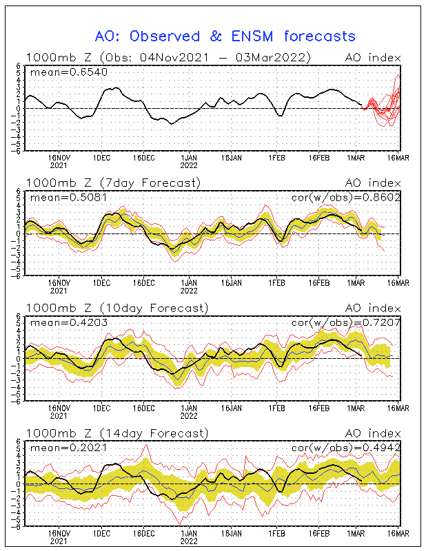
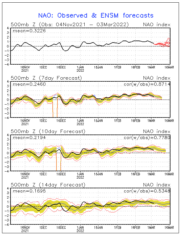
Well now, look at this!! The latest teleconnections forecasts are out and for the very first time in my recent memory, a -AO and -NAO is being indicated at the same time. The NAO is forecast to tank significantly around mid April. So, it may be very possible we may see some significant cold spells to come down into the Eastern CONUS come later this month. We already have one decent cold spell coming by next weekend (4/9- 4/10) across the Eastern CONUS. April is shaping up potentially to be quite interesting for very late season cold.


0 likes
NEVER, EVER SAY NEVER in the tropics and weather in general, and most importantly, with life itself!!
________________________________________________________________________________________
Fay 2008 Beryl 2012 Debby 2012 Colin 2016 Hermine 2016 Julia 2016 Matthew 2016 Irma 2017 Dorian 2019
________________________________________________________________________________________
Fay 2008 Beryl 2012 Debby 2012 Colin 2016 Hermine 2016 Julia 2016 Matthew 2016 Irma 2017 Dorian 2019
-
HURRICANELONNY
- Category 5

- Posts: 1392
- Joined: Wed May 07, 2003 6:48 am
- Location: HOLLYWOOD.FL
Re: Florida Weather
Sometimes the NAO/AO flip flop like a pair of wiper blades but trend is good 
0 likes
hurricanelonny
Return to “USA & Caribbean Weather”
Who is online
Users browsing this forum: Pas_Bon and 30 guests


