Texas Summer 2012
Moderator: S2k Moderators
Forum rules

The posts in this forum are NOT official forecast and should not be used as such. They are just the opinion of the poster and may or may not be backed by sound meteorological data. They are NOT endorsed by any professional institution or STORM2K.

Speaking of mega highs, GFS and Euro are forecasting 105+ surface temps in north and northeast Texas next week. 100+ I-35 and east. Near 110 are even shown at times. However it is a week away and given soil moisture I would probably shave off 3-5 degrees from those raw numbers. Hopefully the models are WRONG.
0 likes
The above post and any post by Ntxw is NOT an official forecast and should not be used as such. It is just the opinion of the poster and may or may not be backed by sound meteorological data. It is NOT endorsed by any professional institution including Storm2k. For official information, please refer to NWS products.
Help support Storm2K!
-
weatherdude1108
- Category 5

- Posts: 4228
- Joined: Tue Dec 13, 2011 1:04 pm
- Location: Northwest Austin/Cedar Park, TX
Re: Texas Summer 2012
Portastorm wrote:South Texas Storms wrote::uarrow:
Too much uncertainy exists right now to rule out rain for us from that possible tropical disturbance.
Anyway, here is my latest weather article. Our weather could get interesting by this weekend.
http://www.examiner.com/article/possibl ... -for-texas
I definitely agree. South central Texas has a decent shot at rain tomorrow as the upper-level low is in a position to create the most instability in our part of the state. Furthermore, I'm not convinced yet that this supposed super-high pressure dome will squash any and all Gulf moisture to our south for the next week.
I'm definitely enjoying this recent thread of conversation, whether or not it comes true. These tropical air masses tend to fool the models sometimes.
Meanwhile, I'm eyeing the radar and the rain bands inch their way towards Austin. I think the south side may be getting in on the action. Here's hoping the Austin rain shield and dome of death can be breached, and the glass will get more than half-full!
 I'll be fine whatever happens, because El Nino is coming.
0 likes
-
Portastorm

- Storm2k Moderator

- Posts: 9955
- Age: 63
- Joined: Fri Jul 11, 2003 9:16 am
- Location: Round Rock, TX
- Contact:
Re: Texas Summer 2012
weatherdude1108, I think someone short-circuited the Austin Rain Shield. Some parts of town just enjoyed a brief tropical shower. Hope there is more of that to come!
0 likes
Any forecasts under my name are to be taken with a grain of salt. Get your best forecasts from the National Weather Service and National Hurricane Center.
-
Rgv20

- S2K Supporter

- Posts: 2466
- Age: 39
- Joined: Wed Jan 05, 2011 5:42 pm
- Location: Edinburg/McAllen Tx
A couple of days ago I was expecting a very wet weekend here in deep south texas but now I'm not to sure about that.......Those forecast models cant seem to make up their mind! My head hurts lol
0 likes
The following post is NOT an official forecast and should not be used as such. It is just the opinion of the poster and may or may not be backed by sound meteorological data. It is NOT endorsed by any professional institution including storm2k.org For Official Information please refer to the NHC and NWS products.
-
weatherdude1108
- Category 5
- Posts: 4228
- Joined: Tue Dec 13, 2011 1:04 pm
- Location: Northwest Austin/Cedar Park, TX
Re: Texas Summer 2012
Portastorm wrote:weatherdude1108, I think someone short-circuited the Austin Rain Shield. Some parts of town just enjoyed a brief tropical shower. Hope there is more of that to come!
Just got brief downpour, with several claps of thunder in North Austin!!
Streets around are steaming. Have our own free sauna out in the parking lot!
Very nice!
0 likes
-
weatherdude1108
- Category 5
- Posts: 4228
- Joined: Tue Dec 13, 2011 1:04 pm
- Location: Northwest Austin/Cedar Park, TX
Keeping my hopes up:
AREA FORECAST DISCUSSION
NATIONAL WEATHER SERVICE AUSTIN/SAN ANTONIO TX
305 PM CDT TUE JUN 19 2012
.DISCUSSION...
A MID LEVEL TROUGH DRIFTS SLOWLY WEST ACROSS SOUTHERN TEXAS TONIGHT
AND INTO MEXICO BY WEDNESDAY NIGHT. A SOUTHEASTERLY LOWER LEVEL
FLOW MAINTAINS A MOIST AIRMASS ACROSS SOUTH CENTRAL TEXAS WITH PWS
OF 1.4 INCHES WEST TO 2.0 INCHES EAST. SHOWERS AND THUNDERSTORMS
OVER THE EAST DECREASE THIS EVENING WITH LOSS OF HEATING. SHOWERS
INCREASE EARLY WEDNESDAY MORNING NEAR THE COASTAL PLAINS AND
SPREAD WEST WITH THUNDERSTORMS ACROSS MUCH OF SOUTH CENTRAL TEXAS
DURING THE DAY AS THE AIRMASS WARMS. SOME LOCALLY HEAVY DOWNPOURS
ARE POSSIBLE MAINLY IN THE EAST. SHOWERS AND THUNDERSTORMS
DECREASE WEDNESDAY EVENING WITH LOSS OF HEATING. THE TROUGH MOVES
FURTHER SOUTHWEST INTO MEXICO THURSDAY AS THE SUBTROPICAL RIDGE
CENTERED OVER NORTHWESTERN MEXICO SHIFTS NORTHEAST INTO THE
SOUTHERN PLAINS AND TEXAS. ISOLATED SHOWERS AND THUNDERSTORMS ARE
EXPECTED THURSDAY WHILE THE AIRMASS REMAINS MOIST. THE SUBTROPICAL
RIDGE BECOMES DOMINANT ACROSS THE SOUTHERN PLAINS AND TEXAS FRIDAY
THROUGH AT LEAST THE MIDDLE OF NEXT WEEK. A WEAKENING SURFACE FLOW
AND SUBSIDENCE BRINGING DRY AIR FROM ALOFT ALLOWS THE AIRMASS TO
DRY WITH PWS DROPPING BELOW 1.5 INCHES. NO RAIN IS EXPECTED AND
TEMPERATURES BECOME WELL ABOVE AVERAGE WITH HIGHS NEAR 100 ACROSS
MUCH OF SOUTH CENTRAL TEXAS BY SUNDAY INTO MONDAY AS THE SOIL
DRIES OUT. UNTIL THEN...FOR WEDNESDAY AND THURSDAY...TEMPERATURES
WILL BE NEAR OR SLIGHTLY BELOW AVERAGE DUE TO CLOUDS AND RAIN. OF
NOTE...THE NOGAPS IS AN OUTLIER IN BRINGING AN UPPER LEVEL LOW AND
CHANCES OF RAIN WEST INTO TEXAS THIS WEEKEND OR EARLY NEXT WEEK.WILL FOLLOW ALL OF THE OTHER MODELS IN KEEPING IT IN THE CENTRAL
GULF OF MEXICO.
LOOKING BEYOND THIS FORECAST AT THE LONGER RANGES OF THE GFS...THE
NEXT CHANCES OF RAIN MAY BE LATE NEXT WEEK ON THE 29TH OR 30TH OF
JUNE WHEN A WEAK SURFACE BOUNDARY SAGS SOUTH INTO CENTRAL TEXAS AS
NOTED ON THE 12Z RUN OR NOT UNTIL 1ST THROUGH 3RD OF JULY WHEN A
SHEAR AXIS SET UPS ALONG OR JUST INLAND OF THE TEXAS COAST AS
NOTED ON THE 00Z/06Z RUNS.
0 likes
The preceding post is NOT an official forecast, and should not be used as such. It is only the opinion of the poster and may or may not be backed by sound meteorological data. It is NOT endorsed by any professional institution including storm2k.org. For Official Information please refer to the NHC and NWS products.
-
weatherdude1108
- Category 5
- Posts: 4228
- Joined: Tue Dec 13, 2011 1:04 pm
- Location: Northwest Austin/Cedar Park, TX
I saw that! I haven't seen the movie though, so I thought it was a real pic.lol
Meanwhile, I drove into work and got sprinkled on with a combination of dry and wet streets, enough to put dirty spots on the car but not wash it off.
A neighbor said it rained about 45 seconds at the house this morning after I left, then more substantially an hour later.
These cells are moving so fast. Wish we'd get a big cluster move over to cover more square mileage before the death ridge sets back in this weekend for who knows how long(?).
Apparently that stuff in the SE Gulf is expected to move towards Florida (according to Bob Rose's weather blog Tuesday the 19th) where they don't need it. Meanwhile, we wither away in the Central Texas desert.
But, the glass is half-full! I'm looking forward to El Nino's eventual effects after getting through this Summer!
http://www.lcra.org/water/conditions/we ... olumn.html
0 likes
The preceding post is NOT an official forecast, and should not be used as such. It is only the opinion of the poster and may or may not be backed by sound meteorological data. It is NOT endorsed by any professional institution including storm2k.org. For Official Information please refer to the NHC and NWS products.
Happy summer solstice! Today is the longest day of the year and marks the beginning of the downtrend in daylight. Unfortunately this does not mean temperatures react to it. We'll usually get an uptick in heat around this date and next week will do just that.
Models have backed off a bit on the extreme heat (near 110) for the eastern half the state and now shows 97-105 which is more reasonable. Still almost a week away, so hoping the downtrend continues. The heat will the lag effect of a -PNA. By month's end the PNA should head back to neutral if not positive. That would mean early July could provide some relief in terms of rain.
Models have backed off a bit on the extreme heat (near 110) for the eastern half the state and now shows 97-105 which is more reasonable. Still almost a week away, so hoping the downtrend continues. The heat will the lag effect of a -PNA. By month's end the PNA should head back to neutral if not positive. That would mean early July could provide some relief in terms of rain.
0 likes
The above post and any post by Ntxw is NOT an official forecast and should not be used as such. It is just the opinion of the poster and may or may not be backed by sound meteorological data. It is NOT endorsed by any professional institution including Storm2k. For official information, please refer to NWS products.
Help support Storm2K!
Help support Storm2K!
-
weatherdude1108
- Category 5
- Posts: 4228
- Joined: Tue Dec 13, 2011 1:04 pm
- Location: Northwest Austin/Cedar Park, TX
-
weatherdude1108
- Category 5
- Posts: 4228
- Joined: Tue Dec 13, 2011 1:04 pm
- Location: Northwest Austin/Cedar Park, TX
"ONE FINAL SHOT OF RAIN TODAY BEFORE CONDITIONS TURN HOT AND DRY THROUGH NEXT WEEK."
Oh how I would love it if the disturbance in the southern Gulf would decide to turn left towards Texas and not get caught in the upper level low, steering IT towards Florida, where they DO NOT need the rain. I know it is Summer time now, so no surprises here, but it has acted like Summer for over a month.
Ah well. Weather has a mind of it's own. At least my house got 0.15-inch out of yesterday's moisture.
PREV DISCUSSION... /ISSUED 311 AM CDT THU JUN 21 2012/
DISCUSSION...
ONE FINAL SHOT OF RAIN TODAY BEFORE CONDITIONS TURN HOT AND DRY
THROUGH NEXT WEEK. THE WEAKNESS IN THE UPPER LEVEL PATTERN THAT
HELPED SUPPORT CONVECTION WEDNESDAY WILL ALSO SUPPORT CONVECTION
TODAY. HOWEVER A BUILDING RIDGE FROM THE SOUTHWEST WILL LIMIT THE
DEVELOPMENT SLIGHTLY. THE BEST CHANCES FOR RAIN WILL BE ALONG THE
COASTAL PLAINS DURING THE DAY AND THE RIO GRANDE DURING THE EARLY
EVENING. FRIDAY WILL SEE THE RIDGE CONTINUE TO BUILD OVER THE AREA
TURNING CONDITIONS HOT AND DRY.
MODELS DIVERGE OVER THE WEEKEND WITH THE DISTURBANCE OVER THE
SOUTHERN GULF. THE NAM AND CANADIAN HAVE THE DISTURBANCE GETTING
BROUGHT TOWARDS TEXAS AROUND THE BASE OF THE RIDGE OVER THE
SOUTHERN PLAINS. HOWEVER...THE GFS AND ECMWF HAVE THE DISTURBANCE
BEING STEERED TOWARDS FLORIDA AND EVENTUALLY INGESTED INTO THE
DEVELOPING TROUGH OVER THE NORTHEAST STATES. STUCK CLOSER TO THIS
SOLUTION AS THE NAM AND CANADIAN ARE A LITTLE SLOW ON DEVELOPING
THE NORTHEAST TROUGH AND THUS BRING THE RIDGE TOO FAR EAST.
BY THE START OF NEXT WEEK AN OMEGA BLOCKING PATTERN WILL BE WELL
DEVELOPED WITH SOUTH CENTRAL TEXAS ON THE SUBSIDENCE SIDE OF THE
RIDGE. THIS WILL LEAD TO DAYTIME HIGH TEMPERATURES SEVERAL DEGREES
ABOVE SEASONAL NORMALS AND POSSIBLY NEAR RECORD TEMPERATURES IN
SPOTS FOR THE LATTER PART OF NEXT WEEK.
0 likes
The preceding post is NOT an official forecast, and should not be used as such. It is only the opinion of the poster and may or may not be backed by sound meteorological data. It is NOT endorsed by any professional institution including storm2k.org. For Official Information please refer to the NHC and NWS products.
-
Portastorm
- Storm2k Moderator
- Posts: 9955
- Age: 63
- Joined: Fri Jul 11, 2003 9:16 am
- Location: Round Rock, TX
- Contact:
Re: Texas Summer 2012
Who knows weatherdude ... the Texas "play" for the developing Gulf system is still out there. We shall see.
0 likes
Any forecasts under my name are to be taken with a grain of salt. Get your best forecasts from the National Weather Service and National Hurricane Center.
Re: Texas Summer 2012
This probably should be posted in the tropics but since it regards a lot to Texas I'm going to post here. I've gone through a lot of runs (and lack of tropical knowledge at that  ) but I do believe the system will miss the trough and dig in behind the ridge as it expands due to the fact it is taking so long to organize. I made a post that if it was not heading to Florida by Sunday-ish us Texans should make plans for a wet week. These dry forecasts for next week are in trouble imo.
The major models have slowly backed away from the heat. Because this tropical system is derived from a monsoonal MJO wave I think it's less likely to get caught up into the significant weather patterns (troughs). Classic homebrew style. Don't count out rain yet weatherdude
The major models have slowly backed away from the heat. Because this tropical system is derived from a monsoonal MJO wave I think it's less likely to get caught up into the significant weather patterns (troughs). Classic homebrew style. Don't count out rain yet weatherdude
0 likes
The above post and any post by Ntxw is NOT an official forecast and should not be used as such. It is just the opinion of the poster and may or may not be backed by sound meteorological data. It is NOT endorsed by any professional institution including Storm2k. For official information, please refer to NWS products.
Help support Storm2K!
Help support Storm2K!
-
weatherdude1108
- Category 5
- Posts: 4228
- Joined: Tue Dec 13, 2011 1:04 pm
- Location: Northwest Austin/Cedar Park, TX
Re: Texas Summer 2012
Ntxw wrote:This probably should be posted in the tropics but since it regards a lot to Texas I'm going to post here. I've gone through a lot of runs (and lack of tropical knowledge at that
The major models have slowly backed away from the heat. Because this tropical system is derived from a monsoonal MJO wave I think it's less likely to get caught up into the significant weather patterns (troughs). Classic homebrew style. Don't count out rain yet weatherdude
I won't. I promise!
AREA FORECAST DISCUSSION
NATIONAL WEATHER SERVICE AUSTIN/SAN ANTONIO TX
247 PM CDT THU JUN 21 2012
.DISCUSSION...
MID/LONG-RANGE MODELS CONTINUE TO BE IN LACKLUSTER AGREEMENT WITH
HOW TO HANDLE THE BROAD UPPER DISTURBANCE CURRENTLY NEAR THE
YUCATAN PENINSULA. THE ECMWF AND CMC AGREE ON DEVELOPING A CLOSED
LOW IN THE EASTERN GULF OF MEXICO...BUT THEN DIFFER ON ITS
EVENTUAL TRACK/TIMING. MEANWHILE...THE GFS KEEPS THE SYSTEM AS AN
ELONGATED TROUGH SPREAD ACROSS FLORIDA AND THE GULF THROUGH THE
WEEKEND AND EARLY NEXT WEEK BEFORE GETTING SWEPT INTO THE FLOW OF
AN UPPER LOW DEVELOPING ACROSS THE NORTHEASTERN US. THE ECMWF AND
CMC EVENTUALLY TRACK THE SYSTEM INTO THE WESTERN GULF LATE NEXT
WEEK...JUST BEYOND THE OFFICIAL FORECAST PERIOD. FOR THE TIME
BEING HAVE KEPT SOUTH CENTRAL TEXAS DRY AND HOT THROUGH THE MIDDLE
OF NEXT WEEK AS THE MODELS CAN AT LEAST AGREE ON RIDGING REMAINING
CENTERED ACROSS THE TX/OK PANHANDLE REGION.
Your explanation makes perfect sense to me. I guess I'm a little bias towards wet, but putting it objectively with the MJO, seems like it would help things out for us. But I'm no expert, especially with Texas weather. Just rolling with the punches.
0 likes
The preceding post is NOT an official forecast, and should not be used as such. It is only the opinion of the poster and may or may not be backed by sound meteorological data. It is NOT endorsed by any professional institution including storm2k.org. For Official Information please refer to the NHC and NWS products.
-
Rgv20
- S2K Supporter
- Posts: 2466
- Age: 39
- Joined: Wed Jan 05, 2011 5:42 pm
- Location: Edinburg/McAllen Tx
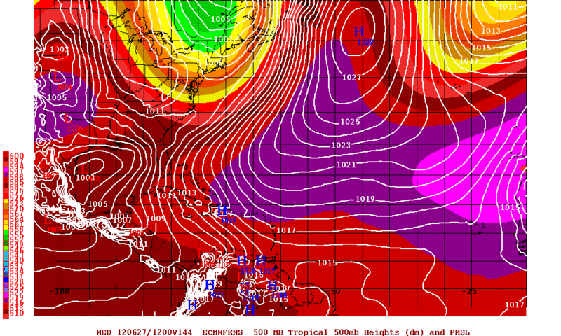
I took a look at the 12zECMWF&CMC Ensemble Means and they favor a western gulf coast storm.
A post I made about 96L, I think it belongs here too!
First of all this is the 12zCMC Ensemble Means Forecast Valid for Tuesday Morning, all I have to say is WOW....The timing of this possible TC is almost identical as to this morning 12zUKMET. IMO this may be a little to fast..
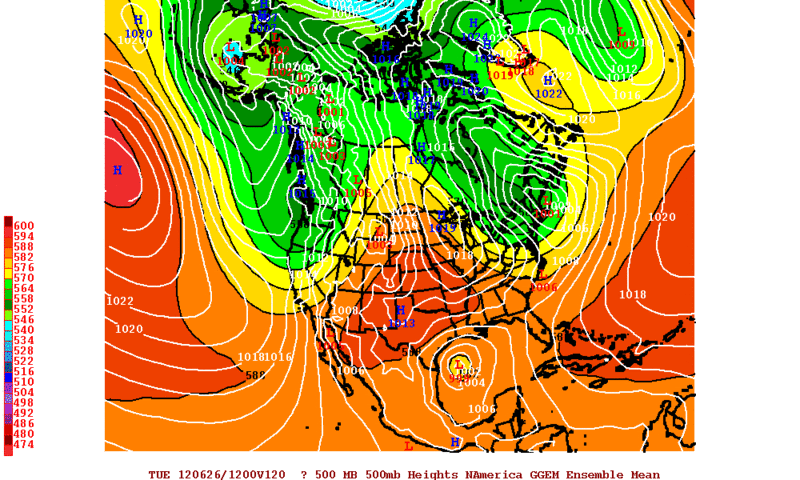
12zECMWF Ensemble Means favor a TC due east of Brownsville by Wednesday Morning, which is just to the WSW of the Operational Run of the ECMWF. If the ECMWF is going to keep the TC in Western GOM in future runs IMO it will trend to the South of this morning run.
A post I made about 96L, I think it belongs here too!
First of all this is the 12zCMC Ensemble Means Forecast Valid for Tuesday Morning, all I have to say is WOW....The timing of this possible TC is almost identical as to this morning 12zUKMET. IMO this may be a little to fast..
12zECMWF Ensemble Means favor a TC due east of Brownsville by Wednesday Morning, which is just to the WSW of the Operational Run of the ECMWF. If the ECMWF is going to keep the TC in Western GOM in future runs IMO it will trend to the South of this morning run.
0 likes
The following post is NOT an official forecast and should not be used as such. It is just the opinion of the poster and may or may not be backed by sound meteorological data. It is NOT endorsed by any professional institution including storm2k.org For Official Information please refer to the NHC and NWS products.
-
horselattitudesfarm

- Category 1

- Posts: 315
- Joined: Thu Jul 16, 2009 5:55 pm
- Location: Asheville, NC (formerly from Dallas, TX)
Re: Texas Summer 2012
IMHO, Just like the dog's favorite bathroom spot, I think the Death Ridge will come back to its favorite spot right over Texas and stay here a while.  I think hot and dry is the mantra for a while. At least this is a more normal time of year for it and the cooler wetter weather was nice while it lasted. For those of you who got chinced on the rain the last few weeks.....my prayers are with you.... as well as for those of you depending on a 40-foot-low lake Travis (lower than at this time last year) to get you through this upcoming loitiering of the Death Ridge. Lets hope the gulf will 'put-out' and start throwing some stuff our way.
I think hot and dry is the mantra for a while. At least this is a more normal time of year for it and the cooler wetter weather was nice while it lasted. For those of you who got chinced on the rain the last few weeks.....my prayers are with you.... as well as for those of you depending on a 40-foot-low lake Travis (lower than at this time last year) to get you through this upcoming loitiering of the Death Ridge. Lets hope the gulf will 'put-out' and start throwing some stuff our way.
0 likes
-
horselattitudesfarm
- Category 1
- Posts: 315
- Joined: Thu Jul 16, 2009 5:55 pm
- Location: Asheville, NC (formerly from Dallas, TX)
By the way, it could be much worse. Look at these Monday record temps:
McCook, Neb. 109
106 (2002)
Sidney, Neb. 105*
100 (2002)
Pueblo, Colo. 104
104 (1936, 1990)
Denver, Colo. 100
99 (1936, 1990)
Colorado Springs, Colo. 98
96 (1936, 1990)
And I thought I was going to Colorado to get AWAY from the heat!
McCook, Neb. 109
106 (2002)
Sidney, Neb. 105*
100 (2002)
Pueblo, Colo. 104
104 (1936, 1990)
Denver, Colo. 100
99 (1936, 1990)
Colorado Springs, Colo. 98
96 (1936, 1990)
And I thought I was going to Colorado to get AWAY from the heat!
0 likes
-
weatherdude1108
- Category 5
- Posts: 4228
- Joined: Tue Dec 13, 2011 1:04 pm
- Location: Northwest Austin/Cedar Park, TX
A little “fly in the ointment” this morning. Interesting how things can change in one day! Ntwx's scenario is unfolding as I type!
PREV DISCUSSION... /ISSUED 413 AM CDT FRI JUN 22 2012/
DISCUSSION...
TWO SIGNIFICANT EVENTS ARE LINING UP OVER THE NEXT 7 DAYS...THE FIRST
BEING A STRONG HIGH PRESSURE RIDGE ALREADY BUILDING OVER TX...AND
THE SECOND BEING A TROPICAL DISTURBANCE THAT MODELS SHOW AN
INCREASING POTENTIAL TO IMPACT SOUTH TX NEXT WEEK.
THE UPPER RIDGE WILL SURGE NE FROM THE SWRN US/MEX BORDER INTO OK
BY SUNDAY...BRINGING OPPRESSIVE HEAT TO MUCH OF TX. LOW TO MID
LEVEL DRY AIR WILL SPILL SOUTHWEST AND MIX OUT THE MOISTURE THAT
FELL OVER SOME AREAS OVER THE WEEKEND TO BRING A GRADUALLY DAILY
INCREASE IN AFTERNOON TEMPS. BY MONDAY...NEARLY ALL OF SOUTH
CENTRAL TEXAS IS EXPECTED TO HIT THE CENTURY MARK...AND SOME
LOCATIONS COULD APPROACH 110. DURING THIS PERIOD...A LIGHT
SURFACE WIND ENVIRONMENT IS EXPECTED WITH AFTERNOON WIND SHIFTS TO
E/NE AFTER MIXING WITH THE AIR ALOFT. THUS IN RELATIVE ABSENCE OF
MOISTURE...TEMPERATURES WITH LOW RH COULD BE HIGHER THAN THE HEAT
INDICES IN SOME AREAS. THE HWO WILL THUS ADDRESS HIGH TEMPERATURES
AS A CONCERN IN PLACE OF HEAT INDICES. THE LIGHT WINDS WOULD ALSO
HELP OVERNIGHT TEMPS TO COOL TO WELL BELOW 80 AT LEAST IN THE
EARLY PART OF THE WEEK.
THE NEXT FEATURE TO WATCH FOR IS THE BROAD SURFACE LOW OVER THE
GULF WHICH IS FORECAST BY MOST MODEL DATA TO DEVELOP INTO A
DEPRESSION AND THREATEN TX. CONFIDENCE REMAINS ESPECIALLY LOW WITH
THIS SYSTEM DUE TO THE BROAD SIZE OF THE CIRCULATION AND DUE TO
SOME MODELS STILL TRACKING THE ENERGY EASTWARD. INFORMATION FROM
THE NHC ON THIS FEATURE WILL NEED TO BE MONITORED CLOSELY.
0 likes
The preceding post is NOT an official forecast, and should not be used as such. It is only the opinion of the poster and may or may not be backed by sound meteorological data. It is NOT endorsed by any professional institution including storm2k.org. For Official Information please refer to the NHC and NWS products.
-
weatherdude1108
- Category 5
- Posts: 4228
- Joined: Tue Dec 13, 2011 1:04 pm
- Location: Northwest Austin/Cedar Park, TX
Re: Texas Summer 2012
horselattitudesfarm wrote:IMHO, Just like the dog's favorite bathroom spot, I think the Death Ridge will come back to its favorite spot right over Texas and stay here a while.
The forecast has already gone from "no hope" yesterday to "a taste of hope" today with the disturbance in the Gulf. Anything is up for grabs. I'm not betting on it based on recent history of systems bypassing or drying us out on the back side of them, causing, among other things, deadly wildfires. Of course the ground moisture is in better shape, at least this week! I'm always trying to keep the glass half-full.
0 likes
-
Rgv20
- S2K Supporter
- Posts: 2466
- Age: 39
- Joined: Wed Jan 05, 2011 5:42 pm
- Location: Edinburg/McAllen Tx
Brownsville early morning discussion.....Giant Elephant in the Room! lol
THE GIANT ELEPHANT IN THE ROOM THIS MORNING IS THE POTENTIAL
TROPICAL DEVELOPMENT IN THE NORTHWESTERN CARRIBEAN AND THE SOUTHERN
GULF OF MEXICO. NHC HAS INDICATED THERE IS ABOUT A 70 PERCENT CHANCE
THIS SYSTEM WILL DEVELOP INTO A TROPICAL CYCLONE WITHIN THE NEXT 48
HOURS. GUIDANCE VARIES WILDLY FROM ONE MODEL TO THE NEXT AND ONE RUN
TO THE NEXT WITH DETERMINISTIC AND ENSEMBLE MODELS SUGGESTING A
PLETHORA OF FINAL LANDFALLS FROM NEAR THIS REGION ALL THE WAY TO
WESTERN FLORIDA. OTHER GUIDANCE DISSIPATES THE SYSTEM WELL BEFORE IT
MOVES TOWARDS SHORE OR LEAVES IT STALLED IN THE GULF FOR DAYS AT A
TIME. THE BOTTOM LINE IS THAT IT IS VERY EARLY IN THE PROCESS AND ABOUT
THE ONLY THING WE CAN RELIABLY SAY IS THAT THERE IS POTENTIAL FOR
TROPICAL DEVELOPMENT IN THE GULF OF MEXICO AND ALL INTERESTS IN THE
VALLEY AND DEEP SOUTH TEXAS SHOULD MONITOR THE PROGRESS OF THIS
SYSTEM AND UPDATED FORECASTS REGARDING IT THROUGH THIS WEEKEND.
REGARDING THE FORECAST...HEAVY MANIPULATION OF THE WIND GRIDS AND
SEAS WAS REQUIRED WITH NO REAL MODEL PREFERENCE. FOLLOWED HPCS BASIC
GUIDANCE ON THE LOCATION OF A POSSIBLE TROPICAL SYSTEM OR A
BROAD/LARGE AREA OF SURFACE LOW PRESSURE AND ASSUMED WE WOULD BE IN
A GENERALLY NORTHERLY AND SUBSIDENT/DRY AIRMASS. WITH THAT KEPT RAIN
CHANCES LOW AND TEMPERATURES FAIRLY HIGH.
0 likes
The following post is NOT an official forecast and should not be used as such. It is just the opinion of the poster and may or may not be backed by sound meteorological data. It is NOT endorsed by any professional institution including storm2k.org For Official Information please refer to the NHC and NWS products.
-
weatherdude1108
- Category 5
- Posts: 4228
- Joined: Tue Dec 13, 2011 1:04 pm
- Location: Northwest Austin/Cedar Park, TX
Re:
Rgv20 wrote:Brownsville early morning discussion.....Giant Elephant in the Room! lol
THE GIANT ELEPHANT IN THE ROOM THIS MORNING IS THE POTENTIAL
TROPICAL DEVELOPMENT IN THE NORTHWESTERN CARRIBEAN AND THE SOUTHERN
GULF OF MEXICO. NHC HAS INDICATED THERE IS ABOUT A 70 PERCENT CHANCE
THIS SYSTEM WILL DEVELOP INTO A TROPICAL CYCLONE WITHIN THE NEXT 48
HOURS. GUIDANCE VARIES WILDLY FROM ONE MODEL TO THE NEXT AND ONE RUN
TO THE NEXT WITH DETERMINISTIC AND ENSEMBLE MODELS SUGGESTING A
PLETHORA OF FINAL LANDFALLS FROM NEAR THIS REGION ALL THE WAY TO
WESTERN FLORIDA. OTHER GUIDANCE DISSIPATES THE SYSTEM WELL BEFORE IT
MOVES TOWARDS SHORE OR LEAVES IT STALLED IN THE GULF FOR DAYS AT A
TIME. THE BOTTOM LINE IS THAT IT IS VERY EARLY IN THE PROCESS AND ABOUT
THE ONLY THING WE CAN RELIABLY SAY IS THAT THERE IS POTENTIAL FOR
TROPICAL DEVELOPMENT IN THE GULF OF MEXICO AND ALL INTERESTS IN THE
VALLEY AND DEEP SOUTH TEXAS SHOULD MONITOR THE PROGRESS OF THIS
SYSTEM AND UPDATED FORECASTS REGARDING IT THROUGH THIS WEEKEND.
REGARDING THE FORECAST...HEAVY MANIPULATION OF THE WIND GRIDS AND
SEAS WAS REQUIRED WITH NO REAL MODEL PREFERENCE. FOLLOWED HPCS BASIC
GUIDANCE ON THE LOCATION OF A POSSIBLE TROPICAL SYSTEM OR A
BROAD/LARGE AREA OF SURFACE LOW PRESSURE AND ASSUMED WE WOULD BE IN
A GENERALLY NORTHERLY AND SUBSIDENT/DRY AIRMASS. WITH THAT KEPT RAIN
CHANCES LOW AND TEMPERATURES FAIRLY HIGH.
I saw that!LOL
0 likes
Return to “USA & Caribbean Weather”
Who is online
Users browsing this forum: Google Adsense [Bot], wxman22 and 165 guests