Texas Fall-2014

U.S. & Caribbean Weather Discussions and Severe Weather Events

Moderator: S2k Moderators

Forum rules

The posts in this forum are NOT official forecast and should not be used as such. They are just the opinion of the poster and may or may not be backed by sound meteorological data. They are NOT endorsed by any professional institution or STORM2K.

Help Support Storm2K
Message
Author
User avatar
ravyrn
S2K Supporter
S2K Supporter
Posts: 989
Age: 41
Joined: Sun Aug 31, 2008 5:10 am
Location: Alderbranch, TX

Re: Texas Fall-2014

#121 Postby ravyrn » Mon Sep 08, 2014 9:47 pm

My post from the Norbert thread:

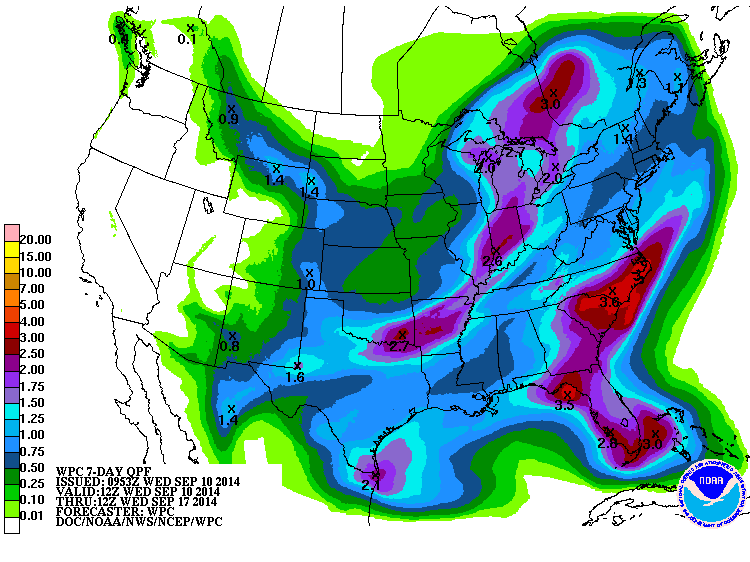
I wouldn't be so quick to dismiss the impact Norbert and its remnants will have on SoCal and Arizona.

NWS Phoenix wrote: AREA FORECAST DISCUSSION
NATIONAL WEATHER SERVICE PHOENIX AZ
1000 AM MST MON SEP 8 2014

.SYNOPSIS...
MOISTURE WILL REMAIN IN PLACE ACROSS THE REGION FOR THE NEXT SEVERAL
DAYS AS FORMER HURRICANE NORBERT APPROACHES THE SOUTHERN CALIFORNIA
COAST. SHOWERS AND THUNDERSTORMS ARE EXPECTED AT TIMES THROUGH
TUESDAY...WITH SOME LOCATIONS POSSIBLY SEEING BRIEF PERIODS OF HEAVY
RAIN. A GRADUAL DRYING TREND IS EXPECTED TO BEGIN BY THE MIDDLE OF
THE WEEK AS HIGH PRESSURE SLOWLY REBUILDS OVER THE REGION.

&&

.DISCUSSION...
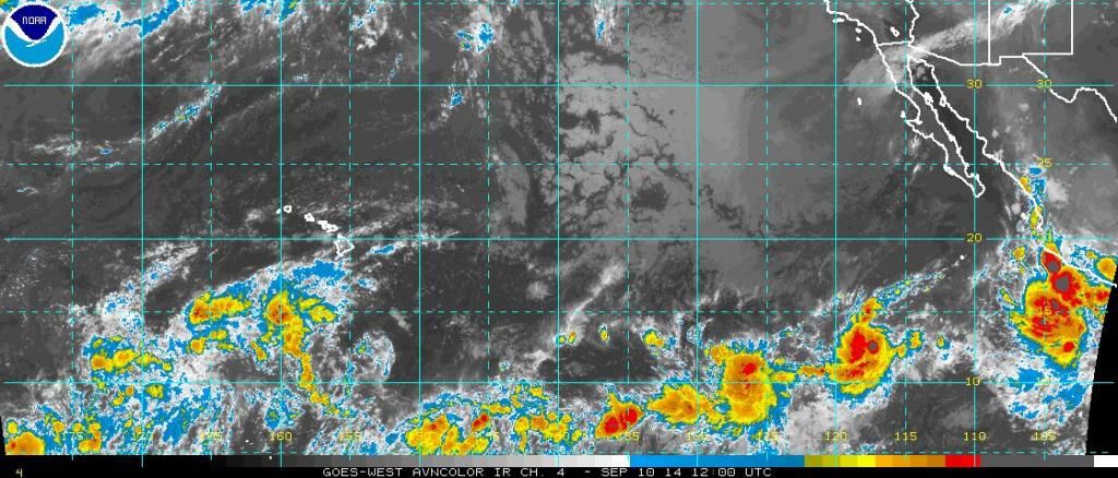
RECORD AMOUNTS OF ATMOSPHERIC MOISTURE HAVE SURGED INTO THE REGION
WITH 12Z KTWC SOUNDING SAMPLING 2.03 INCH PWAT (A RECORD FOR THE
MONTH OF SEPTEMBER). COMBINED WITH ASCENT FROM A WAVE CAUGHT BETWEEN
THE OUTER CIRCULATION OF WHAT WAS NORBERT AND A WAVE IN THE WESTERLY
FLOW ENTERING THE SIERRA...ALL-TIME RECORD RAINFALL HAS FALLEN
THROUGHOUT THE PHOENIX METRO AREA. SKY HARBOR HAS RECORDED 3.29
INCHES OF RAIN BREAKING THE CALENDAR DAY RECORD OF 2.91 INCHES SET
BACK IN 1933.

ADDITIONAL CONVECTION OVER SERN ARIZONA WAS PUSHING NORTH IN
ASSOCIATION WITH A WAVE IN THE H7-H5 LAYER. THIS RAINFALL WILL BE
FOCUSED ACROSS THE SERN PARTS OF THE FORECAST FOR THE REMAINDER OF
THE DAY...WITH SUBSIDENCE AND A MORE STABLE ENVIRONMENT MOVING INTO
PARTS OF WESTERN AND CENTRAL ARIZONA. ON THE OTHER
HAND...INSTABILITY WAS BUILDING OVER SERN CALIFORNIA WITH ANOTHER
WAVE LIFTING INTO SERN NEVADA...SO ADDITIONAL THUNDERSTORM
DEVELOPMENT IS CERTAINLY POSSIBLE THERE.
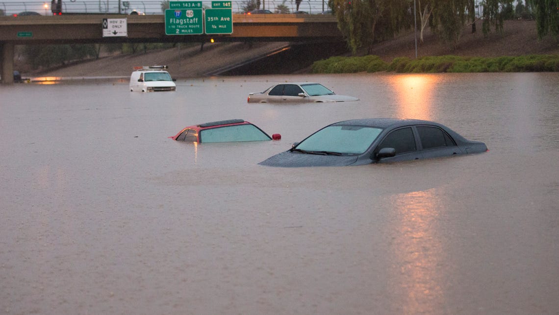
Image
I-10 in Phoenix


Will Norbert's remnants still have any bearing on our weather or did it play out to our west?
0 likes   

User avatar
srainhoutx
S2K Supporter
S2K Supporter
Posts: 6919
Age: 66
Joined: Sun Jan 14, 2007 11:34 am
Location: Haywood County, NC
Contact:

Re: Texas Fall-2014

#122 Postby srainhoutx » Tue Sep 09, 2014 7:42 am

The weekend may offer a chance of seeing some unsettled weather. That cool front does not appear to have much in the way of upper level support or trajectory to bring the chilly air expected in the Northern Plains very far S into Texas. The main upper level energy looks to track across the Northern Plains into the Great Lakes and on E. A front will approach Texas on Thursday and may fire off storms to our N. A secondary piece of upper level energy (short wave) appears to cross the Plains on Friday and that may push the front a bit further S into S Central Texas and perhaps near or just S of the I-10 Corridor. This will not be a 'blue norther' for Texas, so don't expect much of a cool down. Like last weekend when we had a weak boundary draped across the area and torrential rains developed for some last Sunday, a somewhat similar situation may develop as the front serves as focal point for showers/storms to develop. The main issue I see is potential cloudiness as a weak upglide or over running light showers develop inland instead of daytime heating and convective temperature driven storm development along the sea/bay breezes.

The next issue is what becomes of potential Tropical system Odile expected to develop just offshore of the Pacific Coast of Mexico and move NW and possibly turning N across the Baja Peninsula early next week. As witnessed early yesterday across Arizona and Nevada, EPAC tropical systems and their moisture (Post Tropical Cyclone Norbert) can lead to flash flooding particularly in the Desert SW. The Phoenix area received about half a years' worth of annual rainfall Sunday night into yesterday afternoon which was about 7 inches. The fly in the ointment for our Region is some of the models are suggesting deep tropical moisture from the Pacific move ENE across Northern Mexico and into Texas next week. Add to the mix unsettled weather developing in the Western Gulf and stalled boundary and you have a recipe for a possible heavy rainfall event. The monsoonal trough is expected to generate areas of general broad areas of low pressure from the Bay of Campeche across the Isthmus of Tehuantepec into the Eastern Pacific near the Coast of Mexico over the next 5-10 days. There is also indications that convectively couple Kelvin Wave (cckw) will near the area next week as well as some tropical enhancement or lift/rising air which is conducive for thunderstorm development from the MJO (Madden Julian Oscillation). With all that said it does appear that an unsettled pattern may well develop and persist into the end of next week. As always, there is a lot of uncertainty in the forecast and expect changes as we see how things develop over the next several days.
0 likes   
Carla/Alicia/Jerry(In The Eye)/Michelle/Charley/Ivan/Dennis/Katrina/Rita/Wilma/Ike/Harvey

Member: National Weather Association
Wx Infinity Forums
http://wxinfinity.com/index.php

Facebook.com/WeatherInfinity
Twitter @WeatherInfinity

Ntxw
Storm2k Moderator
Storm2k Moderator
Posts: 21565
Joined: Wed Oct 21, 2009 6:34 pm
Location: DFW, Texas

#123 Postby Ntxw » Tue Sep 09, 2014 8:34 am

I agree srain, EPAC will continue to light up. We could be looking at another significant intense cylone there (Odile to be) will be tracking closer to the coast. The supressed KW that quieted down the Atlantic will be exiting for next week. Will need to watch western gulf/carib for potential mischief after this week.
0 likes   
The above post and any post by Ntxw is NOT an official forecast and should not be used as such. It is just the opinion of the poster and may or may not be backed by sound meteorological data. It is NOT endorsed by any professional institution including Storm2k. For official information, please refer to NWS products.

  Help support Storm2K!
Help Support Storm2K

User avatar
Tireman4
S2K Supporter
S2K Supporter
Posts: 5679
Age: 58
Joined: Fri Jun 30, 2006 1:08 pm
Location: Humble, Texas
Contact:

#124 Postby Tireman4 » Tue Sep 09, 2014 9:00 am

From the HGX AFD this morning:

000
FXUS64 KHGX 090942
AFDHGX

AREA FORECAST DISCUSSION
NATIONAL WEATHER SERVICE HOUSTON/GALVESTON TX
442 AM CDT TUE SEP 9 2014

.DISCUSSION...
YESTERDAY`S LESSENED CONVECTIVE COVERAGE CAN BE ATTRIBUTED TO THE
SAME FACTORS THAT WILL AID IN SUPPRESSING TODAY`S SHOWER AND STORM
ACTIVITY...RELATIVELY DRIER AIR WITH SLIGHTLY STRONGER UPPER RIDGING
LEADING TO NON-DIFFULENT/UNI-DIRECTIONAL NORTHWEST UPPER LEVEL FLOW.
WATER VAPOR IMAGERY NICELY DEPICTING THIS SWATH OF DRY AIR FROM CENTRAL
TEXAS EAST INTO LOUISIANA...SATELLITE DERIVED VALUES DIPPING BELOW
2 INCH PWATS. TODAY AND WEDNESDAY`S AREAL PRECIPITABLE COVERAGE OF
NO MORE THAN 20-30% IS FORECAST BASED UPON THE STATIC NATURE OF THIS
MORNING`S DRIER AND (SLIGHTLY) MORE STABLE PATTERN...ALONG WITH NO
UPPER LEVEL SUPPORT WITHIN ANTI-CYCLONIC FLOW.

THE MAIN WEATHER STORY THIS WEEK WILL BE THE ARRIVAL OF A FRIDAY/SATURDAY
COLD FRONTAL. ALTHOUGH RECENT MODEL RUNS HAVE WAVERED IN THE CONFIDENCE
OF THE TIMING AND STRENGTH OF THIS BOUNDARY...IT IS STILL FORECAST
TO MAKE A SOUTHEASTERN TEXAS ENTRANCE LATE FRIDAY INTO EARLY SATURDAY.
QUITE THE TROUGH DIGGING INTO THE PACIFIC NORTHWEST BUT IT WILL ENCOUNTER
SOUTHERN PLAINS FLATTENED RIDGING. THE BACKING AIR MASS WILL BE FAIRLY
COLD AND DRY FOR THIS TIME OF YEAR...BUT LATEST NWP MODELING KEEPS
THE COLDEST AIR OFF TO THE NORTH AND EAST WITH AN ANTICIPATED MILDER
TURN TO WEEKEND WEATHER. THE TRAJECTORY OF THE 1030-ISH MB SURFACE
HIGH OUT OF SOUTHERN CANADA SATURDAY MAY NOT TAKE THAT PREFERRED STRAIGHT
SOUTH MERIDIONAL TREK (FOR A `COOL OUTBREAK`)...MORE OF AN EASTERLY
COMPONENT TO ITS EVENTUAL EVOLUTION INTO CENTRAL CONUS. THIS WILL AFFECT
THE BOUNDARY`S TRACK TOWARDS THE COAST...MOST LIKELY SLOWLY IT UP
OVER THE CWA LATE FRIDAY INTO EARLY SATURDAY. WHAT IS OF HIGHER CONFIDENCE
IS A BACKING WIND TO THE NORTHEAST...MORE OVERCAST INHIBITING AFTERNOON
WARMTH TO THE MEAN UPPER 80S. WHAT WILL BE FINE TUNED IN THE COMING
DAYS WILL BE THE QPF...ALL DETERMINANT UPON THE NATURE OF THE CONVERGENT
FOCUS PROVIDED BY WHAT APPEARS TO BE A MORE-DIFFUSE LOW-MID LEVEL BOUNDARY.
AS OF NOW...GRIDS REFLECT LOW TO MODERATE CONFIDENCE OF FRIDAY AND SATURDAY
PRECIPITATION. THE MAIN QUESTION WILL BE IF WE ARE FACING A HIGH RAINFALL
EVENT GOING INTO THE WEEKEND. DOMINANT EASTERLY FLOW THROUGH EARLY NEXT
WEEK MAY STEER EASTERN-BASED SHORTWAVE DISTURBANCES INTO AN ALREADY
UNSETTLED AND HIGHLY MOIST UPPER TEXAS COASTAL ENVIRONMENT. THEREFORE...
SLIGHT CHANCE COASTAL COUNTY AND MARITIME POPS WILL REMAIN AS BOOKMARKS
TO ACCOUNT FOR THIS GENERALLY LOWER PRESSURE/UNSETTLED GULF OF MEXICO
PATTERN. 31
0 likes   

User avatar
dhweather
S2K Supporter
S2K Supporter
Posts: 6163
Joined: Sat Aug 14, 2004 9:29 pm
Location: Heath, TX
Contact:

Re: Texas Fall-2014

#125 Postby dhweather » Tue Sep 09, 2014 3:32 pm

Putting images up like this can be cruel, particularly when it DOESN'T HAPPEN.


Image


Finger, toes, legs, arms and eyes crossed. :lol:
0 likes   
The above post and any post by dhweather is NOT an official forecast and should not be used as such. It is just the opinion of the poster and may or may not be backed by sound meteorological data. It is NOT endorsed by any professional institution including storm2k.org. For official information, please refer to NWS products.

Ntxw
Storm2k Moderator
Storm2k Moderator
Posts: 21565
Joined: Wed Oct 21, 2009 6:34 pm
Location: DFW, Texas

#126 Postby Ntxw » Tue Sep 09, 2014 4:00 pm

Tropical connection? Norbert remnants/94E - CHECK

Lift Mechanism? Cold front - CHECK

Looks good for 1-3 inches, unless you live within favored donut hole locales :wink:
0 likes   
The above post and any post by Ntxw is NOT an official forecast and should not be used as such. It is just the opinion of the poster and may or may not be backed by sound meteorological data. It is NOT endorsed by any professional institution including Storm2k. For official information, please refer to NWS products.


  Help support Storm2K!

Help Support Storm2K


User avatar
Rgv20
S2K Supporter
S2K Supporter
Posts: 2458
Age: 37
Joined: Wed Jan 05, 2011 5:42 pm
Location: Edinburg/McAllen Tx

#127 Postby Rgv20 » Tue Sep 09, 2014 4:03 pm

12zECMWF Ensemble Means shows 1'' to 1.5'' of Rain thru Monday Morning for the RGV area....Not bad for an Ensemble Mean 6 days out!

NWS Brownsville afternoon discussion.

FRIDAY LOOKS QUITE A BIT WETTER STILL ALTHOUGH THERE ARE SOME SUBTLE
TIMING DIFFERENCES BETWEEN THE GFS AND ECMWF BOTH BRING IN THE
BAROCLINICALLY GENERATED 500MB CUTOFF LOW AND A TRUE EASTERLY WAVE
WITH A NOTABLE INVERTED TROUGH SIGNATURE UP TO 700MB MAINLY DURING
THE DAY ON FRIDAY. FORECAST SOUNDINGS/CROSS SECTIONS REVEAL A
SIGNIFICANT INCREASE IN TOTAL COLUMN RELATIVE HUMIDITY DURING THE
DAY FRIDAY. BOTH THE GFS AND ECMWF ALSO SEND A SHALLOW COLD FRONT
INTO SOUTH TEXAS ON FRIDAY AS WELL. THE AIRMASS CHANGE AND BETTER
850MB SUPPORT APPEARS TO DIMINISH BY THE TIME THE WIND SHIFT
ARRIVES...BUT THAT WIND SHIFT WOULD PROVIDE ADDITIONAL SURFACE
CONVERGENCE WITH A STRONGLY CONVERGENT 850/700MB LAYER ALREADY IN
PLACE FROM THE EASTERLY WAVE. WENT WITH 60 POPS FOR THE VALLEY
FRIDAY AFTERNOON DUE TO THE JUXTAPOSITION OF ALL OF THESE THINGS.

I BELIEVE THE EASTERLY WAVE WILL WIN OUT IN TERMS OF TOTAL WEATHER
INFLUENCE AND KEEP ANY REAL AIRMASS CHANGE AT BAY...BUT THE
NORTHERLY WIND SHIFT AND EXTRA FRONTAL LIFT SEEMS PLAUSIBLE AS A
PROCESS OCCURRING UNDER THE INFLUENCE OF THE 850/700 MB TROPICAL WAVE
AND THE 500MB BAROCLINICALLY GENERATED CLOSED LOW. THE CLOSED LOW
SLOWS AND I THINK THE CONVECTIVE PROCESSES ASSOCIATED WITH THE WAVE
BEGIN TO INFLUENCE ITS TRACK AS THE 300MB LOW PRESSURE CENTER
DISSOLVES. THIS WOULD LIKELY RESULT IN MORE TRULY TROPICAL
PROCESSES...AND KEPT RAIN CHANCES UP DURING THE OVERNIGHT HOURS TO
ALLOW FOR AN UPSWING IN CONVECTION DURING MINIMUM HEATING/THE 3 TO 6
AM HOURS FRIDAY NIGHT.

SATURDAY THE FRONTAL INFLUENCE BECOMES MORE DIFFUSE IN THE GFS...AND
PERSISTS IN THE ECMWF SIGNAL AND IN BOTH THE DEEP MOIST EASTERLY
FLOW CONTINUES AND KEPT AT LEAST 50 PCT RAIN CHANCES IN MOST OF THE
AREA DURING THE DAY AS THERE IS GOOD LOWER LAYER CONVERGENCE AND
ABUNDANT MOISTURE REGARDLESS OF WHETHER SURFACE WINDS ARE EASTERLY
OR NORTHEASTERLY.

MID AND LOWER LEVEL RIDGING RETURNS TO THE NORTH CENTRAL GULF MONDAY
INTO TUESDAY AND TAPERED OVERALL RAIN CHANCES DOWN A BIT BUT KEPT
SLIGHT CHANCE POPS IN ALMOST AREA WIDE THROUGH MONDAY AND TUESDAY
BECAUSE MID AND LOWER LEVEL MOISTURE NEVER COMPLETELY CLEARS OUT AND
THE 850/700MB RELATIVE HUMIDITY VALUES LOOK TO REMAIN HIGH ENOUGH
FOR SCATTERED AFTERNOON SHOWERS/STORMS AND DID GO TO 30 PCT IN THE
AFTERNOON IN THE FAVORED SEABREEZE ZONE WITH LIGHT EASTERLY TO
SOUTHEASTERLY SURFACE FLOW CONTINUING.

EVALUATING THE HEAVY RAINFALL/FLOODING POTENTIAL OR LOOKING AT TOTAL
EVENT RAINFALL IS VERY DIFFICULT. ALTHOUGH GLOBAL GUIDANCE DOES NOT
SUGGEST IT THERE WOULD BE AT LEAST A SMALL POTENTIAL FOR SOME FORM
OF CONVECTIVE INDUCED CYCLONE DEVELOPMENT WHICH COULD RADICALLY
ALTER PRECIP PATTERNS. BUT ASSUMING THE CURRENT GLOBAL MODEL
CONSENSUS OF STRONG WAVE WITH NO REAL TROPICAL ORGANIZATION
CONTINUES THE POTENTIAL FOR A WIDESPREAD 1 TO 2 INCHES OF RAINFALL
EXISTS. PRECIPITABLE WATER VALUES WILL BE AROUND 2.1 INCHES BUT
FLASH FLOOD GUIDANCE ESPECIALLY IN THE 3 TO 6 HOUR WINDOW REMAINS
PRETTY HIGH. TOO EARLY TO REALLY GET A FEEL FOR THE POTENTIAL FOR
MORE WIDESPREAD FLOODING WORRIES...BUT CANT RULE IT COMPLETELY OUT
GIVEN THE PATTERN AND SEPTEMBERS PENCHANT FOR WET WEATHER IN THE
RGV. /68-JGG/
0 likes   
The following post is NOT an official forecast and should not be used as such. It is just the opinion of the poster and may or may not be backed by sound meteorological data. It is NOT endorsed by any professional institution including storm2k.org For Official Information please refer to the NHC and NWS products.

weatherdude1108
Category 5
Category 5
Posts: 4176
Joined: Tue Dec 13, 2011 1:04 pm
Location: Northwest Austin/Cedar Park, TX

#128 Postby weatherdude1108 » Tue Sep 09, 2014 4:22 pm

Trending wetter according to the EWX group. But they are still being cautious about it.

000
FXUS64 KEWX 092037 CCA
AFDEWX

AREA FORECAST DISCUSSION...CORRECTED
NATIONAL WEATHER SERVICE AUSTIN/SAN ANTONIO TX
335 PM CDT TUE SEP 9 2014

.SHORT TERM (TONIGHT THROUGH WEDNESDAY NIGHT)...
HIGH PRESSURE ALOFT WILL PROLONG THE ABOVE NORMAL TEMPERATURES FOR
A FEW MORE FORECAST PERIODS. HIGH HUMIDITIES IN THE MORNING
SUGGEST UNCOMFORTABLE LOW TEMPS IN THE MID TO UPPER 70S ACROSS
COUNTIES ALONG AND SE OF THE ESCARPMENT TONIGHT AND WEDNESDAY
NIGHT. THE DAYTIME CONDITIONS COULD BE SLIGHTLY LESS UNPLEASANT IN
TERMS OF HEAT INDICES AS WATER VAPOR IMAGERY AND MODEL DEPICTIONS
OF DRIER MID-LEVEL AIR COULD ACT TO MIX OUT THE DAYTIME DEW POINTS
WHILE PROVIDING A STEADY SOUTH BREEZE. NEVERTHELESS...A FEW AREAS
OF THE COASTAL PRAIRIES AND RIO GRANDE PLAINS COULD EXPECT TO SEE
HEAT INDICES AROUND 105 WEDNESDAY AFTERNOON.

&&

.LONG TERM (THURSDAY THROUGH TUESDAY)...
A WELCOME WEATHER CHANGE ENTERS THE PICTURE LATE THURSDAY AFTER
ANOTHER HOT AFTERNOON. THE NHC AND SEVERAL MODELS ARE SHOWING
INCREASED CONFIDENCE IN ANOTHER PACIFIC TROPICAL CYCLONE FORMING A
COUPLE HUNDRED MILES S OF ACAPULCO. MEANWHILE A MUCH ANTICIPATED
COLD FRONT APPROACHES THE NORTHERN HILL COUNTRY. MODELS HAVE SHOWN
SOME SLOWING TRENDS ON THE ARRIVAL OF THE FRONT...BUT A MOISTENING
TREND ALONG AND BEHIND THE FRONT TO HELP STRENGTHEN ITS POSITION
ONCE IT ARRIVES. THE SLOWER AND SLIGHTLY MORE DRAMATIC ECMWF IS
THEREFORE FAVORED ON THE SCENARIO...BUT THE ONGOING DROUGHT
CONDITIONS AND TIMING UNCERTAINTIES HAVE THIS FORECAST PACKAGE
HESITANT TO USE THE HIGHER POPS
.

GIVEN THESE PREFERENCES...THE FORECAST ASSUMES A CONVECTIVE
ENVIRONMENT TO CONCENTRATE ACTIVITY MOSTLY NORTH OF THE AREA
THURSDAY NIGHT WITH A SLOW PASSAGE FRIDAY INTO FRIDAY NIGHT. DEW
POINTS ARE EXPECTED TO REMAIN HIGH FRIDAY NIGHT LEADING TO NEAR
NORMAL MIN TEMPS...BUT FOLLOWED BY HIGHS WELL BELOW NORMALS BY
SATURDAY AFTERNOON. DURING THIS FRONTAL TRANSITION PERIOD...THERE
REMAINS A GOOD DEAL OF UNCERTAINTY ON MOISTURE AMOUNTS AVAILABLE
FOR CONVECTION...BUT MODEL MOISTENING TRENDS WITH TIME SUGGESTS
THAT PWAT VALUES COULD REACH 2 INCHES ALONG THE FRONT. IF THE
TRENDS CONTINUE...LATER FORECAST PACKAGES MAY NEED TO ASSESS THE
POTENTIAL FOR HEAVY RAINFALL.

THE TRENDS AND FORECAST OF THE POTENTIAL PACIFIC TROPICAL CYCLONE
SHOULD HAVE SQUEEZED MUCH OF THE LIFE OUT OF THE UPPER RIDGE
BY THE WEEKEND...BUT MODEL CONSENSUS ON THE RIDGE POSITION IS
STILL OVER CENTRAL TX. IN FOLLOWING THE ECMWF SOLUTION...WILL
ASSUME OVERRUNNING AND FRONTAL REINFORCEMENT FROM PRECIPITATION TO
KEEP THE TEMPERATURES MODIFIED THROUGH THE EARLY PART OF NEXT
WEEK. WILL SHIFT POPS AND TEMPS IN THE EARLY NEXT WEEK PERIODS
TOWARD THE WARMER GFS AND CLIMATOLOGY FOR NOW.
0 likes   
The preceding post is NOT an official forecast, and should not be used as such. It is only the opinion of the poster and may or may not be backed by sound meteorological data. It is NOT endorsed by any professional institution including storm2k.org. For Official Information please refer to the NHC and NWS products.

Ntxw
Storm2k Moderator
Storm2k Moderator
Posts: 21565
Joined: Wed Oct 21, 2009 6:34 pm
Location: DFW, Texas

#129 Postby Ntxw » Tue Sep 09, 2014 7:28 pm

I think NWS FW is being a little optimistic with Friday's forecasted high of 84. Unless that is just before frontal passage, because what I'm seeing it's going to struggle to get to 70. It should be in the 60s most of the day with clouds, drizzle, and a N/NE breeze.
0 likes   
The above post and any post by Ntxw is NOT an official forecast and should not be used as such. It is just the opinion of the poster and may or may not be backed by sound meteorological data. It is NOT endorsed by any professional institution including Storm2k. For official information, please refer to NWS products.


  Help support Storm2K!

Help Support Storm2K


weatherdude1108
Category 5
Category 5
Posts: 4176
Joined: Tue Dec 13, 2011 1:04 pm
Location: Northwest Austin/Cedar Park, TX

#130 Postby weatherdude1108 » Tue Sep 09, 2014 7:53 pm

I saw this story today posted by the EWX office on Facebook. That is A LOT of water! :double:

Sept. 8–10, 1921: Rainstorm. Probably the greatest rainstorm in Texas history, it entered Mexico as a hurricane from the Gulf. Torrential rains fell as the storm moved northeasterly across Texas. Record floods occurred in Bexar, Travis, Williamson, Bell and Milam counties, killing 215 persons, with property losses over $19 million. Five to nine feet of water stood in downtown San Antonio. A total of 23.98 inches was measured at the U.S. Weather Bureau station at Taylor during a period of 35 hours, with a 24-hour maximum of 23.11 on September 9-10. The greatest rainfall recorded in United States history during 18 consecutive hours (measured at an unofficial weather-monitoring site) fell at Thrall, Williamson County, 36.40 inches fell on Sept. 9.

http://www.texasalmanac.com/topics/envi ... ther-1920s
0 likes   

User avatar
Ptarmigan
Category 5
Category 5
Posts: 5273
Joined: Wed Aug 16, 2006 9:06 pm

Re:

#131 Postby Ptarmigan » Tue Sep 09, 2014 10:08 pm

weatherdude1108 wrote:I saw this story today posted by the EWX office on Facebook. That is A LOT of water! :double:

Sept. 8–10, 1921: Rainstorm. Probably the greatest rainstorm in Texas history, it entered Mexico as a hurricane from the Gulf. Torrential rains fell as the storm moved northeasterly across Texas. Record floods occurred in Bexar, Travis, Williamson, Bell and Milam counties, killing 215 persons, with property losses over $19 million. Five to nine feet of water stood in downtown San Antonio. A total of 23.98 inches was measured at the U.S. Weather Bureau station at Taylor during a period of 35 hours, with a 24-hour maximum of 23.11 on September 9-10. The greatest rainfall recorded in United States history during 18 consecutive hours (measured at an unofficial weather-monitoring site) fell at Thrall, Williamson County, 36.40 inches fell on Sept. 9.

http://www.texasalmanac.com/topics/envi ... ther-1920s


I read 38.2 inches of rain fell. It was caused by remnant of Hurricane #2. :eek:

http://en.wikipedia.org/wiki/September_ ... nio_floods
0 likes   

User avatar
Rgv20
S2K Supporter
S2K Supporter
Posts: 2458
Age: 37
Joined: Wed Jan 05, 2011 5:42 pm
Location: Edinburg/McAllen Tx

#132 Postby Rgv20 » Tue Sep 09, 2014 11:08 pm

Looks like most of Texas is in for a wet next 7 days!

Today's 0zWPC forecast rainfall for the next 7 days..
Image
0 likes   
The following post is NOT an official forecast and should not be used as such. It is just the opinion of the poster and may or may not be backed by sound meteorological data. It is NOT endorsed by any professional institution including storm2k.org For Official Information please refer to the NHC and NWS products.

User avatar
Tireman4
S2K Supporter
S2K Supporter
Posts: 5679
Age: 58
Joined: Fri Jun 30, 2006 1:08 pm
Location: Humble, Texas
Contact:

#133 Postby Tireman4 » Wed Sep 10, 2014 8:01 am

From the HGX AFD this morning:

000
FXUS64 KHGX 100940
AFDHGX

AREA FORECAST DISCUSSION
NATIONAL WEATHER SERVICE HOUSTON/GALVESTON TX
440 AM CDT WED SEP 10 2014

.DISCUSSION...
A FEW FACTORS THAT WILL AGAIN SIGNIFICANTLY LIMIT TODAY`S
CONVECTIVE COVERAGE. ONE IS THE CONTINUED STRENGTH OF THE
FLATTENED MID TO UPPER RIDGE WHOSE AXIS IS GENERALLY CENTERED
ACROSS THE STATE/31 DEG NORTH LATITUDE. DESPITE THE SOUTHERN
STEERING FLOW...RELATIVELY LOWER COLUMN MOISTURE OVER EASTERN
TEXAS IS ANOTHER FACTOR. REGIONAL GULF COASTAL SOUNDINGS OF
BETWEEN 1.5 TO 1.8 INCH PWAT VALUES...ALONG WITH WATER VAPOR
IMAGERY...VERIFY THIS RECENT DRYING OF THE RESIDENT AIR MASS.
ISOLATED SHOWERS TRANSITIONING FROM OFFSHORE TO ONSHORE THROUGH
THE MORNING...ISOLATED AFTERNOON INLAND STORMS IN THE VICINITY OF
THE MESOSCALE BREEZES/GUST FRONT BOUNDARIES. DUE TO LESSENED AREAL
RAINFALL AND MORE SUNSHINE TO THE SURFACE...AVERAGE MAXIMUM
TEMPERATURES WILL AGAIN BE IN THE MIDDLE 90S...OR THE WARMEST OF
THE WEEK. A VERY SIMILAR REGIONAL WEATHER PATTERN WILL BE ON TAP
FOR THURSDAY...AS WELL.

WESTERN CANADIAN PROVINCE ENERGY DIVING DOWN INTO THE BASE OF A
GREAT BASIN UPPER LEVEL TROUGH WILL ONLY DEEPEN IT AS IT ADVANCES
INTO THE GREAT PLAINS FRIDAY. LOWERING LEE PRESSURES WILL DEVELOP
A SURFACE TROUGH THAT WILL BE THE FRONT THAT WILL TRAVEL ACROSS
EASTERN TEXAS FRIDAY AFTERNOON INTO EVENING. A SHALLOW FRONT...
SOUTHEAST SURFACE WINDS WILL SLOWLY BACK TO EAST-NORTHEAST FRIDAY
AS MID-LEVEL WINDS WILL LAG BEHIND AND CREATE AN EFFICIENT OVER-
RUNNING SITUATION. GULF-IN-ORIGIN SLUGS OF GREATER THAN 2.1-2.2
INCH PWAT AIR MASS(ES) WILL POOL AHEAD OF THIS APPROACHING INLAND
BOUNDARY. MEANWHILE...A BAY OF CAMPECHE EASTERLY WAVE/REGION OF
DISTURBED TROPICAL WEATHER WILL AID IN PULLING THIS HIGHER MOIST
AIR...ALONG ITS NORTHERN FLANK...INTO SOUTHEASTERN TEXAS. THIS
DYNAMIC WILL BE OCCURRING WITHIN A CONDITIONALLY UNSTABLE AIR MASS
WITH ACHIEVABLE CONVECTIVE TEMPERATURES IN THE MIDDLE TO UPPER
80S. THROW IN THE POSSIBILITY OF THIS INLAND TROUGH/COLD FRONT
DRAWING UP A SOUTHERN TEXAS/WESTERN GOM INVERTED (NEAR SURFACE)
TROUGH...IN TANDEM WITH A COUPLE OF PASSING WEAK OFFSHORE SHORTWAVES
CAUGHT UP IN THE EASTERLY FLOW...AND YOU CAN MIX UP A MYRIAD OF
INGREDIENTS NEEDED IN GENERATING WIDESPREAD RAIN AND THUNDERSTORM
ACTIVITY. HENCE...HIGH CHANCE TO LIKELY PRECIPITATION PROBABILITIES
WILL COMMENCE FRIDAY MORNING AND PERSIST THROUGH LATE SATURDAY INTO
EARLY SUNDAY.

DUE TO THE NATURE OF A (NEAR) STATIONARY SURFACE BOUNDARY WAFING
ABOUT THE CWA OVER THE WEEKEND...WEAK LOW TO MID LEVEL STEERING
FLOW WILL LEAN TOWARDS THE CHANCE FOR SLOW-MOVING CELLS PRODUCING
HIGH RAINFALL-LEADING-TO-A-FLOODING THREAT. HIGHER RAIN CHANCES
AND QPF MAY BE FOCUSED OVER THE SOUTHERN CWA ALTHOUGH MOST WILL
PICK UP MEASURABLE RAIN THROUGH THE WEEKEND. AS OF NOW...AVERAGE
QPF WILL BE IN THE QUARTER INCH TO INCH RANGE...LOCALLY GREATER
THAN INCH TOTALS...THROUGH SATURDAY. ALL OF THE QUANTITATIVE ELEMENTS
CONCERNING FRIDAY-SUNDAY`S INCLEMENT WEATHER PATTERN WILL BE BETTER
FINE TUNED IN THE COMING DAYS. OVERCAST...WITH OCCASIONAL RAIN/STORM
EPISODES...WILL RETARD WEEKEND WARMTH TO THE MEAN MIDDLE TO UPPER
80S. THE EXTENDED OUTLOOK DEPICTS HIGHER EARLY WORK WEEK RAIN
PROBABILITIES ACROSS THE COASTAL AND MARITIME ZONES...OR IN THE
VICINITY OF A LINGERING SURFACE BOUNDARY/GREATER THAN 1.8 INCH
PWAT AIR MASS. A GENERALLY UNSETTLED WESTERN GULF PATTERN...WITH
SUBSEQUENT DAY WARMING BACK INTO THE LOWER 90S...MAY KEEP AT LEAST
SLIGHT CHANCE (SOUTHERN CWA) POPS IN PLACE THROUGH PERIOD`S CLOSE.
31

&&

MARINE...
TYPICAL SUMMERTIME PATTERN FOR THE NEXT COUPLE DAYS WITH LIGHT TO
MODERATE SE WINDS PREVAILING. EASTERLY WAVE WILL MOVE ACROSS THE SRN
GULF AND TOWARD THE COAST OF MEXICO LATE FRI. INITIAL SURGE OF
MOISTURE SHOULD LEAD TO INCREASING PRECIP COVERAGE IN THE WATERS
BEGINNING FRI MORNING ALONG WITH A SLIGHT BUMP UP IN SEAS. WINDS
WILL BACK TO THE E THEN PROBABLY NE EARLY SATURDAY AS A FRONTAL
BOUNDARY NEARS THE COAST. STILL HAVING THE RECENT DILEMMA WITH 12Z
MODEL RUNS BULLISH REGARDING A GOOD PUSH INTO THE GULF...WHEREAS 00Z
RUNS AREN`T AS DISTINCT. KEPT ONGOING FCST PRETTY MUCH AS-IS FOR
CONSISTENCY SAKE FOR NOW. REGARDLESS...LINGERING MOISTURE WILL KEEP
RAIN CHANCES IN THE FCST THRU THE WEEKEND AND INTO NEXT WEEK IN THE
WATERS. 47

&&


AVIATION...
SOME PATCHY MVFR CIGS POSSIBLE THRU MID MORNING LIFTING INTO VFR
TERRITORY LATE MORNING & REMAINDER OF THE DAY. EXPECT SOME ISOLATED
PRECIP TO DEVELOP ALONG THE COASTAL COUNTIES 16-18Z GRADUALLY SPREADING
INLAND DURING THE AFTN. LIKELY YDAY OVERALL COVERAGE SHOULD BE FAIRLY
SPARSE & IMPACTS PROBABLY MINIMAL ENOUGH TO EXCLUDE FROM 12Z TAFS.
WILL JUST AMEND IF BECOMES NECESSARY. RINSE/REPEAT TONIGHT & THURS.
47
0 likes   

User avatar
srainhoutx
S2K Supporter
S2K Supporter
Posts: 6919
Age: 66
Joined: Sun Jan 14, 2007 11:34 am
Location: Haywood County, NC
Contact:

Re: Texas Fall-2014

#134 Postby srainhoutx » Wed Sep 10, 2014 8:16 am

A rather complex and complicated forecast continues to develop over the next week or so. The upper ridge will remain in control today into tomorrow across our Region and then changes lurk as a ‘cool front’ sags S into Texas and likely pulls up stationary across Central Texas tomorrow evening. A secondary surge of ‘cooler air’ associated with an upper air disturbance embedded within the trough across the Central United States will push the frontal boundary further S and eventually stall somewhere along the NE Mexico/Coastal Texas/Louisiana area offshore on Saturday. Showers/storms may accompany the front as high PW’s of 2+ inches pool along and S of the front. This front will likely not clear us out as over running clouds and showers develop behind the front throughout the weekend into next week.

To further complicate the weather picture is a surge of tropical moisture originating from the Western Caribbean moving into the Western Gulf as a tropical wave moves W into the Bay of Campeche tomorrow. There are some indications that a weak area of low pressure may form in the SW Gulf tomorrow into Friday as well. To further complicate things, Eastern Pacific Tropical Depression 15E has formed SSW of Acapulco and is drifting NNW. That tropical cyclone is expected to develop into a Category 2 Hurricane as it near the Baja Peninsula Sunday into Monday next week. Deep tropical moisture from that cyclone may spread ENE across Northern Mexico into Texas early next week. Additionally, the convectively coupled Kelvin Wave we have mentioned is progressing E across the Pacific toward Mexico and should arrive in the Western Atlantic Basin in the next 7 to 10 days enhancing tropical convection development across the SW Caribbean and the Western Gulf. We can see the convective enhancement occurring across the Eastern Pacific with 3 areas of disturbed weather (TD 15E, 95E, 96E). The monsoon trough across the SW Caribbean into the Eastern Pacific remains very active and additional tropical development may be an issue as we head into next week both in the Eastern Pacific and the Western Caribbean and the Western Gulf. Stalled fronts in the NW Gulf tend to raise an eyebrow and the warm water of the Western Caribbean and the Western Gulf are virtually untouched this summer other than TS Dolly. Vertical instability is expected into remain favorable in those areas over the next 7-10 days.

Image

Image
0 likes   
Carla/Alicia/Jerry(In The Eye)/Michelle/Charley/Ivan/Dennis/Katrina/Rita/Wilma/Ike/Harvey

Member: National Weather Association
Wx Infinity Forums
http://wxinfinity.com/index.php

Facebook.com/WeatherInfinity
Twitter @WeatherInfinity

User avatar
Portastorm
Storm2k Moderator
Storm2k Moderator
Posts: 9788
Age: 62
Joined: Fri Jul 11, 2003 9:16 am
Location: South Austin, TX
Contact:

Re: Texas Fall-2014

#135 Postby Portastorm » Wed Sep 10, 2014 10:03 am

:uarrow:

Very nice forecast discussion, sir! Thanks much for laying it all down for us. Interesting weather times ahead for Texas and this week looks to be the end, at least in south central Texas, of wxman57 weather (upper 90s for highs) until next summer.
0 likes   
Any forecasts under my name are to be taken with a grain of salt. Get your best forecasts from the National Weather Service and National Hurricane Center.

I'm a certified Advanced SKYWARN-trained spotter and am active on Twitter at @TravisCOSW, a social media partner of the NWS Austin-San Antonio office.

Ntxw
Storm2k Moderator
Storm2k Moderator
Posts: 21565
Joined: Wed Oct 21, 2009 6:34 pm
Location: DFW, Texas

#136 Postby Ntxw » Wed Sep 10, 2014 10:34 am

CFSv2 looks very wet next 45 days for Texas. Above to well above average rainfall, looks classic El Nino fall signature. Lots of STJ activity and lots of EPAC systems. All across the south-central and southwestern US actually.

Edit: Rising AAM, supports Global winds oscillation responding to El Nino atmospheric conditions.

Image
0 likes   
The above post and any post by Ntxw is NOT an official forecast and should not be used as such. It is just the opinion of the poster and may or may not be backed by sound meteorological data. It is NOT endorsed by any professional institution including Storm2k. For official information, please refer to NWS products.


  Help support Storm2K!

Help Support Storm2K


BrokenGlassRepublicn
Category 1
Category 1
Posts: 479
Joined: Sun Nov 20, 2011 8:07 pm
Location: Richardson, Texas

#137 Postby BrokenGlassRepublicn » Wed Sep 10, 2014 3:16 pm

This place is strangely quiet considering we are mere hours away from putting a bullett into summer temps, not to mention what could be a nice little rain event.
0 likes   

User avatar
Tireman4
S2K Supporter
S2K Supporter
Posts: 5679
Age: 58
Joined: Fri Jun 30, 2006 1:08 pm
Location: Humble, Texas
Contact:

Re:

#138 Postby Tireman4 » Wed Sep 10, 2014 3:28 pm

BrokenGlassRepublicn wrote:This place is strangely quiet considering we are mere hours away from putting a bullett into summer temps, not to mention what could be a nice little rain event.


I think we are just waiting for it to happen....:)
0 likes   

User avatar
Tireman4
S2K Supporter
S2K Supporter
Posts: 5679
Age: 58
Joined: Fri Jun 30, 2006 1:08 pm
Location: Humble, Texas
Contact:

#139 Postby Tireman4 » Wed Sep 10, 2014 3:50 pm

From the HGX AFD this afternoon:

00
FXUS64 KHGX 102022
AFDHGX

AREA FORECAST DISCUSSION
NATIONAL WEATHER SERVICE HOUSTON/GALVESTON TX
322 PM CDT WED SEP 10 2014

.DISCUSSION...
PARTLY CLOUDY SKIES THIS AFTERNOON WITH ONLY A SHOWER OR TWO
THANKS TO UPPER LEVEL RIDGING AND NEAR NORMAL MOISTURE VALUES FOR
THIS TIME OF YEAR. ANOTHER HOT DAY EXPECTED TOMORROW AS A FRONT
WILL SLOWLY PUSH TO THE SOUTH ALLOWING 850 TEMPERATURES TO REMAIN
AROUND 20C. FORECAST SOUNDINGS ALSO SHOW PLENTY OF DRY AIR BETWEEN
600 AND 300 MB. THIS SHOULD HELP TO LIMIT SHOWER AND THUNDERSTORM
ACTIVITY FOR THURSDAY.

ON FRIDAY THE UPPER LEVEL RIDGE WILL BEGIN TO FLATTEN AS A
SECONDARY PIECE OF MID LEVEL ENERGY CURRENTLY OVER MONTANA DIVES
TO THE SOUTH. THIS SECONDARY SURGE OF ENERGY WILL HELP TO PUSH THE
FRONT TO THE COAST SATURDAY MORNING. THE DRIER AND COOLER AIR
WILL REMAIN NORTH OF THE AREA THOUGH. LATE FRIDAY INTO SATURDAY
THE FRONT WILL BE SLOWLY PUSHING THROUGH THE AREA WHICH WILL HELP
INITIATE SHOWER AND THUNDERSTORMS ACTIVITY. GFS IS SHOWING PWATS
CLIMBING TO NEAR 2.30" AHEAD OF THE BOUNDARY (NEAR THE 99TH
PERCENTILE FOR THIS TIME OF YEAR). AT THE SAME TIME A WEAK
DISTURBANCE WILL PUSH INTO MEXICO BRINGING MOIST AIR INTO TEXAS
FROM THE SOUTH. OMEGA FIELDS FROM BOTH THE NAM AND GFS SHOW LIFT
STARTING ALONG A SEA BREEZE FRIDAY AFTERNOON WITH ANOTHER AREA OF
LIFT MOVING IN FROM THE NORTH IN ASSOCIATION WITH FRONT. MAIN
CONCERN FOR FRIDAY AFTERNOON INTO SATURDAY MORNING WILL BE THE
CHANCE OF HEAVY RAIN. FORECAST SOUNDINGS ARE SHOWING STORM
MOTIONS IN THE 5 TO 10 KT RANGE.

AS SATURDAY PROGRESSES THE SHORTWAVE THAT MOVED SOUTH FROM
MONTANA WILL QUICKLY PULL TO THE EAST TAKING THE COOLER AIR WITH
IT. THROUGH THE FIRST PART OF NEXT WEEK BOTH THE ECMWF AND GFS
KEEP THE AREA IN A NORTHWEST FLOW AT THE MID LEVELS. NOT
SUPRISINGLY THIS ALSO ALLOWS FOR UPPER LEVEL DISTURBANCES TO MOVE
ACROSS THE AREA. BECAUSE OF THIS WILL KEEP POPS IN THE FORECAST
THROUGH THE END OF THE PERIOD. 23

&&

.MARINE...

AN INCREASE BACK TO 10-15 KNOTS TONIGHT AND AGAIN THURSDAY EVENING
THEN WILL BE FOLLOWED BY LIGHTER WINDS FRIDAY AS THE FRONT SETTLES
INTO SOUTHEAST TEXAS IN THE AFTERNOON. WINDS ACROSS THE UPPER TEXAS
COASTAL WATERS WILL BACK TO THE EAST AND BE INCREASING FRIDAY NIGHT
AS THE FRONT NEARS. THIS SHOULD IN TURN LEAD TO SLIGHTLY ABOVE NORMAL
TIDE LEVELS FRIDAY NIGHT THROUGH SUNDAY. SCATTERED SHOWERS AND
THUNDERSTORMS WILL BE ON TAP FRIDAY THROUGH SUNDAY WITH THE CLOSE
PROXIMITY OF THE FRONT AND ABUNDANT MOISTURE POOLED OVER THE AREA. 45

&&

.AVIATION...

UPPER RIDGING HOLDING STRONG TODAY AND VFR SHOULD CONTINUE THROUGH
AT LEAST 06Z. STRATUS DECK FORMATION SHOULD ENCOMPASS CLL/UTS/CXO AT
LEAST AT TIMES TOWARD MORNING. ISOLATED SHOWERS AND THUNDERSTORMS
AGAIN TOMORROW.

AVIATION OUTLOOK PERIOD FRIDAY THROUGH SUNDAY EXPECTING WIDESPREAD
IMPACTS ACROSS THE AREA AS FRONT STALLS IN SETX AND SCATTERED TO
NUMEROUS SHOWERS AND THUNDERSTORMS IMPACT THE AREA TERMINALS FRIDAY
LATE IN THE AFTERNOON THROUGH SUNDAY MORNING. 45
0 likes   

Ntxw
Storm2k Moderator
Storm2k Moderator
Posts: 21565
Joined: Wed Oct 21, 2009 6:34 pm
Location: DFW, Texas

#140 Postby Ntxw » Wed Sep 10, 2014 4:20 pm

DFW hit 101F today. Whew talk about going out with a bang, good thing it's probably the last one of the year above 100. Front is on the way, should be crossing the falls soon. Short range guidance develops a line of storms along and behind the front this evening.

1040 surface high in Alberta, not too bad for Sept.

Image
0 likes   
The above post and any post by Ntxw is NOT an official forecast and should not be used as such. It is just the opinion of the poster and may or may not be backed by sound meteorological data. It is NOT endorsed by any professional institution including Storm2k. For official information, please refer to NWS products.


  Help support Storm2K!

Help Support Storm2K


Return to “USA & Caribbean Weather”

Who is online

Users browsing this forum: No registered users and 30 guests