
Texas Summer 2019
Moderator: S2k Moderators
Forum rules

The posts in this forum are NOT official forecast and should not be used as such. They are just the opinion of the poster and may or may not be backed by sound meteorological data. They are NOT endorsed by any professional institution or STORM2K.
-
bubba hotep

- S2K Supporter

- Posts: 6014
- Joined: Wed Dec 28, 2016 1:00 am
- Location: Collin County Texas
-
bubba hotep
- S2K Supporter
- Posts: 6014
- Joined: Wed Dec 28, 2016 1:00 am
- Location: Collin County Texas
-
bubba hotep
- S2K Supporter
- Posts: 6014
- Joined: Wed Dec 28, 2016 1:00 am
- Location: Collin County Texas
Re: Texas Summer 2019
1st watch of the day to our North, those storms seem to be holding together better than any of the HiRes models were showing. If they collapse and spit out an outflow then that could send a push of cool stable air down over DFW shutting off storm chances for later...
0 likes
Winter time post are almost exclusively focused on the DFW area.
-
bubba hotep
- S2K Supporter
- Posts: 6014
- Joined: Wed Dec 28, 2016 1:00 am
- Location: Collin County Texas
Re: Texas Summer 2019

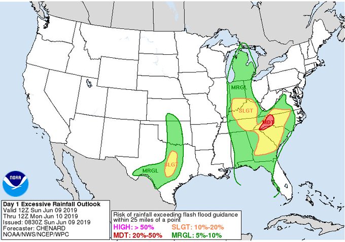
Mesoscale Discussion 1039
NWS Storm Prediction Center Norman OK
1034 AM CDT Sun Jun 09 2019
Areas affected...South-central Oklahoma/north-central Texas
Concerning...Severe Thunderstorm Watch 347...
Valid 091534Z - 091700Z
The severe weather threat for Severe Thunderstorm Watch 347
continues.
SUMMARY...Within Severe Thunderstorm Watch 347, a cluster of
south/southeastward-moving thunderstorms will continue to pose a
damaging wind/some hail risk across south-central OK. Trends are
being closely monitored for the possibility of an additional Watch
across North TX, which could be needed within the hour (before 1130
AM CDT).
DISCUSSION...A south/southeastward-moving cluster (around 35 kt
forward motion) with history of wind damage/periodic severe hail
continues along the I-35 corridor of south-central OK, with the
leading edge nearing the Wyneewood/Davis/Sulphur areas as of 1025 AM
CDT. The linear cluster remains relatively well-organized with a
tight leading-edge reflectivity gradient and signs of moderately
strong rear inflow and a deep cold pool, with 30+ kt winds within
the lowest 2-3km AGL observed in recent KTLX WSR-88D VWP data.
Mid-level temperatures warm and background environmental winds, if
anything, tend to weaken with southward extent. That said, a readily
evident cold pool (accompanied by strong pressure rises) appears to
be relatively well balanced with moist/moderately strong southerly
storm-relative inflow, which may help to maintain severe-caliber
storms with a damaging wind threat into parts of North TX. This is
all while lapse rates will continue to steepen as low-level
inhibition gradually erodes as temperatures warm through the
middle/upper 80s F as of 15Z.
..Guyer.. 06/09/2019
0 likes
Winter time post are almost exclusively focused on the DFW area.
-
bubba hotep
- S2K Supporter
- Posts: 6014
- Joined: Wed Dec 28, 2016 1:00 am
- Location: Collin County Texas
Re: Texas Summer 2019
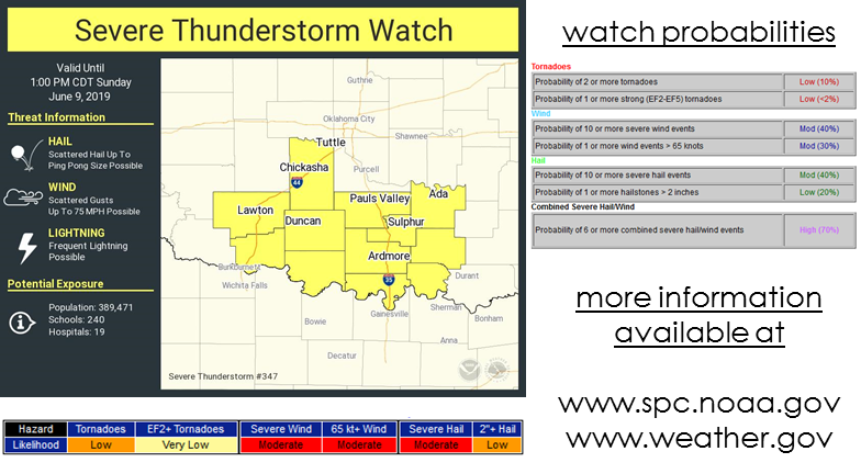
Long duration watch for a relatively small area
2 likes
Winter time post are almost exclusively focused on the DFW area.
-
Brent
- S2K Supporter
- Posts: 38737
- Age: 37
- Joined: Sun May 16, 2004 10:30 pm
- Location: Tulsa Oklahoma
- Contact:
Re: Texas Summer 2019
Well this might at least put a cap on the heat today around here
0 likes
#neversummer


Re: Texas Summer 2019
June front on the way! I repeat a front in June! Solstice is only a week and half away you can't ask for more than 80s for highs and 60s for lows...remember 1980 it can be 113!!!
It will feel more like September than June the next couple of days.
Unusually cool summer on the way.
It will feel more like September than June the next couple of days.
Unusually cool summer on the way.
4 likes
The above post and any post by Ntxw is NOT an official forecast and should not be used as such. It is just the opinion of the poster and may or may not be backed by sound meteorological data. It is NOT endorsed by any professional institution including Storm2k. For official information, please refer to NWS products.
Help support Storm2K!
-
Brent
- S2K Supporter
- Posts: 38737
- Age: 37
- Joined: Sun May 16, 2004 10:30 pm
- Location: Tulsa Oklahoma
- Contact:
Re: Texas Summer 2019
that line moving into Gainesville and Sherman looks like it's gonna make at least the eastern half of the metro
so will there be another round or will this be it?
so will there be another round or will this be it?
0 likes
#neversummer
-
rwfromkansas
- Category 5

- Posts: 3032
- Joined: Sat Aug 27, 2005 12:47 am
- Location: North Fort Worth
Re: Texas Summer 2019
Just got back from a Caribbean cruise. Great weather there. The weather here is way different than what the NWS posted this morning, with a line coming through already, not 4 p.m. Will have to see how that changes things.
0 likes
-
bubba hotep
- S2K Supporter
- Posts: 6014
- Joined: Wed Dec 28, 2016 1:00 am
- Location: Collin County Texas
Re: Texas Summer 2019
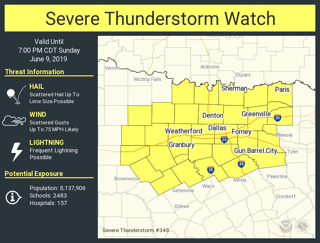
All of DFW metro under warnings now and reports of gust up towards 70 mph with these storms.

0 likes
Winter time post are almost exclusively focused on the DFW area.
-
bubba hotep
- S2K Supporter
- Posts: 6014
- Joined: Wed Dec 28, 2016 1:00 am
- Location: Collin County Texas
Re: Texas Summer 2019
Brent wrote:that line moving into Gainesville and Sherman looks like it's gonna make at least the eastern half of the metro
so will there be another round or will this be it?
Good question, the HiRes models from this morning had storms dying out before even reaching the Red River and then storms firing later along the front. This throws everything out of wack but probably the only storms of the day for DFW given the impressive cold pool behind these batch.
0 likes
Winter time post are almost exclusively focused on the DFW area.
-
srainhoutx

- S2K Supporter
- Posts: 6919
- Age: 68
- Joined: Sun Jan 14, 2007 11:34 am
- Location: Haywood County, NC
- Contact:
Re: Texas Summer 2019
62 kt wind gust reported at Love Field in Dallas. I also see reports of trucks blown over along 635
1 likes
Carla/Alicia/Jerry(In The Eye)/Michelle/Charley/Ivan/Dennis/Katrina/Rita/Wilma/Ike/Harvey
Member: National Weather Association
Wx Infinity Forums
http://wxinfinity.com/index.php
Facebook.com/WeatherInfinity
Twitter @WeatherInfinity
Member: National Weather Association
Wx Infinity Forums
http://wxinfinity.com/index.php
Facebook.com/WeatherInfinity
Twitter @WeatherInfinity
-
rwfromkansas
- Category 5
- Posts: 3032
- Joined: Sat Aug 27, 2005 12:47 am
- Location: North Fort Worth
Re: Texas Summer 2019
Temp has dived with outflow boundary coming out of storm. Think that ends the threat for Tarrant.
1 likes
-
Brent
- S2K Supporter
- Posts: 38737
- Age: 37
- Joined: Sun May 16, 2004 10:30 pm
- Location: Tulsa Oklahoma
- Contact:
Re: Texas Summer 2019
bubba hotep wrote:Brent wrote:that line moving into Gainesville and Sherman looks like it's gonna make at least the eastern half of the metro
so will there be another round or will this be it?
Good question, the HiRes models from this morning had storms dying out before even reaching the Red River and then storms firing later along the front. This throws everything out of wack but probably the only storms of the day for DFW given the impressive cold pool behind these batch.
Yeah the models did horrible today
Even last night the bigger issue was excessive heat lol
0 likes
#neversummer
-
ColdFusion

- S2K Supporter
- Posts: 452
- Joined: Wed Feb 13, 2008 3:46 pm
- Location: Addison, TX
Re: Texas Summer 2019
Impressive winds came with the storms in Addison, TX.
I've been here 3 years and this tarp has never had damage prior to today.
Also knocked out power for about 30 min

I've been here 3 years and this tarp has never had damage prior to today.
Also knocked out power for about 30 min
1 likes
-
rwfromkansas
- Category 5
- Posts: 3032
- Joined: Sat Aug 27, 2005 12:47 am
- Location: North Fort Worth
-
bubba hotep
- S2K Supporter
- Posts: 6014
- Joined: Wed Dec 28, 2016 1:00 am
- Location: Collin County Texas
Re: Texas Summer 2019
In the 50s up in the Panhandle!
2 likes
Winter time post are almost exclusively focused on the DFW area.
Re: Texas Summer 2019
Had a pretty good downpour in Irving but now it is cloud free with a cool wind. Weird. Tomorrow is going to be gorgeous.
2 likes
Re: Texas Summer 2019
srainhoutx wrote:62 kt wind gust reported at Love Field in Dallas. I also see reports of trucks blown over along 635
There was a small hook that passed through near Addison when it rolled through. I happened to be in the area and a lot of tree/branch damage. Some facing the wrong way if considering just straight line winds.
1 likes
The above post and any post by Ntxw is NOT an official forecast and should not be used as such. It is just the opinion of the poster and may or may not be backed by sound meteorological data. It is NOT endorsed by any professional institution including Storm2k. For official information, please refer to NWS products.
Help support Storm2K!
Help support Storm2K!
Return to “USA & Caribbean Weather”
Who is online
Users browsing this forum: CaptinCrunch and 124 guests