#1217 Postby weatherdude1108 » Fri Aug 10, 2018 8:07 am
It might rain here. The hill country is already flooding in parts this morning. That's good, because that's where our water source for our sprinklers are.

 000
000
FXUS64 KEWX 100831
AFDEWX
Area Forecast Discussion
National Weather Service Austin/San Antonio TX
331 AM CDT Fri Aug 10 2018
.SHORT TERM (Today through Saturday)...
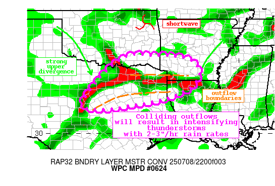
Early morning showers that have formed across the Edwards Plateau in
response to residual outflows and lift associated with the stalled
front are a precursor of what is to come throughout the day today.
The NAM, NMM, and ARW all show the front continuing to sag south
through the say on Friday to around a Rocksprings to Austin to La
Grange line which will focus shower and thunderstorm activity more
across South Central Texas. While the focus today will remain along
and near the boundary across the Edwards Plateau and Hill Country,
coverage of precipitation should begin to increase today. While
general rainfall amounts today should only be between 1/4 and 1/2
inch brief heavy downpours are possible near the boundary which could
result in higher totals. Because of this WPC has left parts of the
Hill Country in a Day 1 Slight Risk for Excessive Rainfall.
As Friday turns into Saturday all 3 major models (ECMWF, GFS, and
NAM) show the trough axis becoming a cut off low. The location of the
low in the 00z guidance tonight has shifted to be more across North
Central Texas rather than West Texas and the Panhandle like last
nights models showed. This has shifted the higher rainfall totals
beginning Saturday from the Midland/San Angelo area to more San
Angelo/Sonora/Rocksprings. With the washed out boundary around, and
the low pressure across North Texas providing needed lift showers and
storms should become more numerous Friday night into Saturday. The
Day 2 Slight Risk of Excessive Rainfall expands over much of the area
west of I-35, but the main focus for the heaviest rainfall will
remain the Edwards Plateau.
The increased cloud cover and precipitation will have the added
benefit of keeping temperatures down across much of South Central
Texas beginning on Saturday. Highs will only reach into the upper 80s
to lower 90s, which is below seasonal normals. Areas farther to the
south, farther from the front and low will see more sunshine and
lower rain chances resulting in warmer temperatures.
&&
.LONG TERM (Saturday Night through Thursday)...
Models are coming into better focus that Saturday night through
Sunday night will be the wettest period of this event. For this 24
hour period the cutoff low will drift across North Texas near the Red
River. Plentiful moisture will be in place, with precipitable water
values of 1.5 to 2 inches for Saturday night through Sunday night.
Residual outflow boundaries, the cutoff low pressure, and the
overnight low level jet will all enhance coverage and intensity of
precipitation. WPC continues the Slight Risk of Excessive rainfall
into Sunday and Sunday night as well. While the focus remains across
the Edwards Plateau for the heaviest rainfall more precipitation is
expected along the I-35 corridor during the Saturday night to Sunday
night timeframe.
With the shifting position of the low pressure system the maxima in
expected rainfall amounts shifted south into Edwards, Real, and Val
Verde County with this round of models. In general areas of the
Edwards Plateau and Rio Grande Plains can expect 2 to 3 inches of
rainfall, with isolated totals as high as 4 to 6 inches by the end of
the day Monday. Farther to the east 1 to 2 inches of rain are
possible along the I-35 corridor through Monday, with totals less
than an inch east of I-35. The new drought monitor that came out
today continued to highlight the increased drought across the Rio
Grande Plains and Edwards Plateau so this rainfall is a welcome
relief to these areas. Chances for precipitation begin to decrease
through the day on Monday as the low pressure begins to lift
northward.
As the ridge builds across the Southern CONUS the cutoff low will
lift into the Central Plains on Tuesday and open up into a broad
trough as it gets absorbed into the flow across the northern half of
the country. This will translate into a drying and warming trend for
the area for Tuesday through the end of the work week. Highs will
climb from the mid 90s on Tuesday to the upper 90s by Wednesday and
Thursday under partly to mostly sunny skies.
1 likes
The preceding post is NOT an official forecast, and should not be used as such. It is only the opinion of the poster and may or may not be backed by sound meteorological data. It is NOT endorsed by any professional institution including storm2k.org. For Official Information please refer to the NHC and NWS products.


 That was weird