Texas Summer 2022
Moderator: S2k Moderators
Forum rules

The posts in this forum are NOT official forecast and should not be used as such. They are just the opinion of the poster and may or may not be backed by sound meteorological data. They are NOT endorsed by any professional institution or STORM2K.


Re: Texas Summer 2022
Some radar estimates a foot of rain in northeast Dallas county. DFW airport has a shot at the monthly record.
2 likes
The above post and any post by Ntxw is NOT an official forecast and should not be used as such. It is just the opinion of the poster and may or may not be backed by sound meteorological data. It is NOT endorsed by any professional institution including Storm2k. For official information, please refer to NWS products.
Help support Storm2K!

Re: Texas Summer 2022
bubba hotep wrote:https://pbs.twimg.com/media/Faw14CWWQAEiCfS?format=png&name=medium
I was wondering how last night would've stacked up against the Mayfest storm from 1995. Ft. Worth got the hail, Dallas got the crazy rain, flooding and drownings.
I vaguely remember the 2001 storm - overnight MCS that just dumped on us IIRC.
Not sure I believe the 2/3/2022 line - wasn't that the day of the winter storm? DFW had a little over 1" of liquid on the 2nd. By midnight on the 3rd we were all below freezing.
2 likes
Re: Texas Summer 2022
DallasAg wrote:bubba hotep wrote:https://pbs.twimg.com/media/Faw14CWWQAEiCfS?format=png&name=medium
I was wondering how last night would've stacked up against the Mayfest storm from 1995. Ft. Worth got the hail, Dallas got the crazy rain, flooding and drownings.
I vaguely remember the 2001 storm - overnight MCS that just dumped on us IIRC.
Not sure I believe the 2/3/2022 line - wasn't that the day of the winter storm? DFW had a little over 1" of liquid on the 2nd. By midnight on the 3rd we were all below freezing.
I don't think the station is DFW. There were some pretty high qpf in the northeastern area back in that Feb ice storm.
Nevertheless, this one is legit up there.
0 likes
The above post and any post by Ntxw is NOT an official forecast and should not be used as such. It is just the opinion of the poster and may or may not be backed by sound meteorological data. It is NOT endorsed by any professional institution including Storm2k. For official information, please refer to NWS products.
Help support Storm2K!
Help support Storm2K!
-
rwfromkansas
- Category 5

- Posts: 3023
- Joined: Sat Aug 27, 2005 12:47 am
- Location: North Fort Worth
Re: Texas Summer 2022
Holy cow already at 2.16 for today so approaching 5 inches now. But, added an inch ridiculously fast.
Edit: at 5.44 so close to Meacham (which makes sense...I'm a few miles north)
Edit: at 5.44 so close to Meacham (which makes sense...I'm a few miles north)
Last edited by rwfromkansas on Mon Aug 22, 2022 8:53 am, edited 2 times in total.
3 likes
-
bubba hotep

- S2K Supporter

- Posts: 6013
- Joined: Wed Dec 28, 2016 1:00 am
- Location: Collin County Texas
Re: Texas Summer 2022
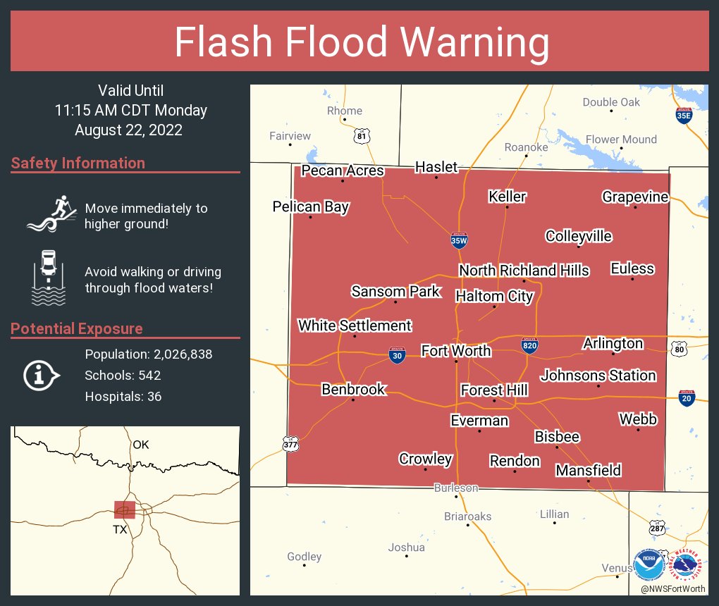
Iceresistance wrote:Flash Flood Warning just issued for Fort Worth
FTW Meacham is now over 6" joining DFW and Love.
2 likes
Winter time post are almost exclusively focused on the DFW area.
-
bubba hotep
- S2K Supporter
- Posts: 6013
- Joined: Wed Dec 28, 2016 1:00 am
- Location: Collin County Texas
Re: Texas Summer 2022
Ntxw wrote:7.2" so far at DFW brings the month to over 8". Some incredible rainfall overnight. 10.33" is the number for wettest Aug and currently #3.
DFW approaching 8", it looks like the monthly record is in jeopardy based on the current radar.
0 likes
Winter time post are almost exclusively focused on the DFW area.
-
Iceresistance

- Category 5
- Posts: 9579
- Age: 22
- Joined: Sat Oct 10, 2020 9:45 am
- Location: Tecumseh, OK/Norman, OK
Re: Texas Summer 2022
This is just incredible, the 7.73 is from Love Field, and the 7.58 is from DFW International Airport. And it's all within 24 hours!
I found the information in the TexMesonet site.

https://s4.gifyu.com/images/Screenshot-2022-08-22-9.05.55-AM.png

https://s4.gifyu.com/images/Screenshot-2022-08-22-9.05.59-AM.png
I found the information in the TexMesonet site.
https://s4.gifyu.com/images/Screenshot-2022-08-22-9.05.55-AM.png
https://s4.gifyu.com/images/Screenshot-2022-08-22-9.05.59-AM.png
2 likes
Bill 2015 & Beta 2020
Winter 2020-2021
All observations are in Tecumseh, OK unless otherwise noted.
Winter posts are focused mainly for Oklahoma & Texas.
Take any of my forecasts with a grain of salt, refer to the NWS, SPC, and NHC for official information
Never say Never with weather! Because ANYTHING is possible!
Winter 2020-2021
All observations are in Tecumseh, OK unless otherwise noted.
Winter posts are focused mainly for Oklahoma & Texas.
Take any of my forecasts with a grain of salt, refer to the NWS, SPC, and NHC for official information
Never say Never with weather! Because ANYTHING is possible!
-
bubba hotep
- S2K Supporter
- Posts: 6013
- Joined: Wed Dec 28, 2016 1:00 am
- Location: Collin County Texas
Re: Texas Summer 2022

Mesoscale Precipitation Discussion 0837
NWS Weather Prediction Center College Park MD
956 AM EDT Mon Aug 22 2022
Areas affected...Dallas-Fort Worth Metro & Along I-20
Concerning...Heavy rainfall...Flash flooding likely
Valid 221355Z - 221800Z
SUMMARY...Additional thunderstorms forming along a warm front and
consistent low level moisture feed ahead of a low level
circulation will continue to trigger thunderstorms containing
prolific rainfall rates. Additional flash flooding in the
immediate Dallas-Fort Worth metro area may result in life
threatening flash flooding this morning.
DISCUSSION...Thunderstorms are tracking over the Dallas-Fort Worth
metro as 15-20 knot southwesterly flow at 850mb continues to
intersect the front, leading to continued mesoscale ascent. SPC
RAP Mesoanalysis depicts a corridor of ~2.4" PWs from the metro
area on east to the ArkLaTex region. Other parameters of interest
include MUCAPE ranging between 1,000-2,000 J/kg, westerly
850-300mb mean flow oriented parallel to the front, deep warm
cloud layers >12,000' AGL, and mean cloud layer RH content >90%.
One of the key items of note in the short term is the low level
circulation north of the surface front where it continues to
generate intense thunderstorms south of Wichita Falls. The latest
RAP shows this 850mb circulation drifting ESE through late
morning, which will bring the storms south of Wichita Falls closer
to the northern periphery of metro area around midday.
The 12Z HRRR's area averaged sounding around the DFW metro at 15Z
today continue to show classic skinny CAPE soundings with ~15 knot
surface-3km shear and surface-3km SRH values of ~100 m2/s2. These
values do support the potential for these cells to contain healthy
low-level mesocyclones, further supporting these ongoing
thunderstorms as efficient rainfall producers. As the MUCAPE
becomes exhausted, convection may form more south of the DFW metro
with ongoing training moving south & east along I-20 where the the
warm front is positioned.
FLASH CREST maximum unit streamflows have rebounded to >1,000
cfs/smi near the Dallas area and storms currently moving through
the Fort Worth metro are also leading to rising streamflows >400
cfs/smi. As the storms move through, already flooded areas could
become more inundated with rainfall, as well as neighboring
communities where soils have become too saturated to soak in
anymore rainfall. Hourly rainfall rates of 2-3"/hr are very much
on the table, and with several more hours of heavy rainfall to
come, additional instances of life threatening flash flooding are
possible in and around the greater Dallas-Fort Worth metro area
and on east along I-20.
Mullinax
ATTN...WFO...FWD...SHV...
ATTN...RFC...WGRFC...NWC...
1 likes
Winter time post are almost exclusively focused on the DFW area.
Re: Texas Summer 2022
bubba hotep wrote:Ntxw wrote:7.2" so far at DFW brings the month to over 8". Some incredible rainfall overnight. 10.33" is the number for wettest Aug and currently #3.
DFW approaching 8", it looks like the monthly record is in jeopardy based on the current radar.
Also 9.57" is the greatest 24 hour total from back in 1932, probably in jeopardy too. This is the mind boggling number due to the recent heavy rain events from 2015-2020 with no event topping the 24 hour one top 10 except for 2018.
3 likes
The above post and any post by Ntxw is NOT an official forecast and should not be used as such. It is just the opinion of the poster and may or may not be backed by sound meteorological data. It is NOT endorsed by any professional institution including Storm2k. For official information, please refer to NWS products.
Help support Storm2K!
Help support Storm2K!
-
jasons2k

- Storm2k Executive

- Posts: 8290
- Age: 52
- Joined: Wed Jul 06, 2005 12:32 pm
- Location: The Woodlands, TX
Re: Texas Summer 2022
Morning email from Jeff:
Heavy rainfall threat will increase from north to south over the next 24 hours.
Impressive overnight urban flash flood event in the Dallas/Fort Worth area with 9.46 inches of rainfall in 6-hr and 7.8 inches in 3-hr. Significant flash flooding has resulted. A 1-hr storm total of 3.01 inches was recorded at DFW with a storm total of 6.54 inches which wiped out 67% of the site’s 2022 rainfall deficit in a few hours.
Frontal boundary over N TX will slowly move southward today and approach the northern portions of SE TX by mid to late afternoon. Numerous showers and thunderstorms will develop along the boundary along with scattered showers developing northward along the seabreeze and Gulf inflow. High resolution guidance is still struggling some with how the convective activity will play out over the next 48 hours. Air mass will become extremely moist and unstable with forecasted PWS of 2.2-2.6 inches and when combined with slow moving/stalled boundaries, a series of upper level disturbances in the NW flow aloft and favorable upper level flow for cell training, excessive rainfall can result. Will favor areas north of HWY 105 this afternoon for the potential for heavy rainfall then slowly sink that southward toward I-10 tonight into early Tuesday. Pattern favors slow storm motions, cell training, and backbuilding of cells to the west and northwest and this all points to heavy rainfall.
While grounds are dry, the local air mass will be capable for some impressive short duration rainfall amounts of 2-4 inches in an hour. This was clearly seen overnight in N TX and the local air mass will not be much different over SE TX, especially N of I-10. These rainfall rates can lead to rapid flash flooding especially in urban areas.
Widespread rainfall amounts of 2-4 inches is expected over much of SE TX through mid week, but isolated higher totals of 6+ inches will be possible, where these higher totals occur, flash flooding will be possible…again the greatest threat at this time looks to be north of I-10.
Confidence in rainfall is high, confidence in rainfall amounts and location of the heaviest rainfall is low.
Street flooding will be the primary threat with the heavy rainfall rates, rises on area creeks and bayou will be possible if some of the heavier storms train or move slowly over any watershed.
Overall wet pattern will linger into late week, but slightly drier air mass and washing out of the surface front should transition back toward a more “normal” cycle of showers and thunderstorms driven mostly by the seabreeze front.
0 likes
-
cheezyWXguy

- Category 5
- Posts: 6281
- Joined: Mon Feb 13, 2006 12:29 am
- Location: Dallas, TX
Re: Texas Summer 2022
jasons2k wrote:Morning email from Jeff:Heavy rainfall threat will increase from north to south over the next 24 hours.
Impressive overnight urban flash flood event in the Dallas/Fort Worth area with 9.46 inches of rainfall in 6-hr and 7.8 inches in 3-hr. Significant flash flooding has resulted. A 1-hr storm total of 3.01 inches was recorded at DFW with a storm total of 6.54 inches which wiped out 67% of the site’s 2022 rainfall deficit in a few hours.
Frontal boundary over N TX will slowly move southward today and approach the northern portions of SE TX by mid to late afternoon. Numerous showers and thunderstorms will develop along the boundary along with scattered showers developing northward along the seabreeze and Gulf inflow. High resolution guidance is still struggling some with how the convective activity will play out over the next 48 hours. Air mass will become extremely moist and unstable with forecasted PWS of 2.2-2.6 inches and when combined with slow moving/stalled boundaries, a series of upper level disturbances in the NW flow aloft and favorable upper level flow for cell training, excessive rainfall can result. Will favor areas north of HWY 105 this afternoon for the potential for heavy rainfall then slowly sink that southward toward I-10 tonight into early Tuesday. Pattern favors slow storm motions, cell training, and backbuilding of cells to the west and northwest and this all points to heavy rainfall.
While grounds are dry, the local air mass will be capable for some impressive short duration rainfall amounts of 2-4 inches in an hour. This was clearly seen overnight in N TX and the local air mass will not be much different over SE TX, especially N of I-10. These rainfall rates can lead to rapid flash flooding especially in urban areas.
Widespread rainfall amounts of 2-4 inches is expected over much of SE TX through mid week, but isolated higher totals of 6+ inches will be possible, where these higher totals occur, flash flooding will be possible…again the greatest threat at this time looks to be north of I-10.
Confidence in rainfall is high, confidence in rainfall amounts and location of the heaviest rainfall is low.
Street flooding will be the primary threat with the heavy rainfall rates, rises on area creeks and bayou will be possible if some of the heavier storms train or move slowly over any watershed.
Overall wet pattern will linger into late week, but slightly drier air mass and washing out of the surface front should transition back toward a more “normal” cycle of showers and thunderstorms driven mostly by the seabreeze front.
Am I reading that right? Does that mean that a 10” storm total would wipe the full 2022 deficit?
0 likes
-
bubba hotep
- S2K Supporter
- Posts: 6013
- Joined: Wed Dec 28, 2016 1:00 am
- Location: Collin County Texas
Re: Texas Summer 2022
Wow... 12z 3k NAM shows another 3-6" rain across portions of DFW after 14z
0 likes
Winter time post are almost exclusively focused on the DFW area.

Re: Texas Summer 2022
DFW continuing to get hammered. Training is continuing.
Further east the additional heavy rain has struggled pushing east into Longview, but moderate rain continues. 5.25" total so far.
Further east the additional heavy rain has struggled pushing east into Longview, but moderate rain continues. 5.25" total so far.
0 likes
Re: Texas Summer 2022
cheezyWXguy wrote:jasons2k wrote:Morning email from Jeff:Heavy rainfall threat will increase from north to south over the next 24 hours.
Impressive overnight urban flash flood event in the Dallas/Fort Worth area with 9.46 inches of rainfall in 6-hr and 7.8 inches in 3-hr. Significant flash flooding has resulted. A 1-hr storm total of 3.01 inches was recorded at DFW with a storm total of 6.54 inches which wiped out 67% of the site’s 2022 rainfall deficit in a few hours.
Frontal boundary over N TX will slowly move southward today and approach the northern portions of SE TX by mid to late afternoon. Numerous showers and thunderstorms will develop along the boundary along with scattered showers developing northward along the seabreeze and Gulf inflow. High resolution guidance is still struggling some with how the convective activity will play out over the next 48 hours. Air mass will become extremely moist and unstable with forecasted PWS of 2.2-2.6 inches and when combined with slow moving/stalled boundaries, a series of upper level disturbances in the NW flow aloft and favorable upper level flow for cell training, excessive rainfall can result. Will favor areas north of HWY 105 this afternoon for the potential for heavy rainfall then slowly sink that southward toward I-10 tonight into early Tuesday. Pattern favors slow storm motions, cell training, and backbuilding of cells to the west and northwest and this all points to heavy rainfall.
While grounds are dry, the local air mass will be capable for some impressive short duration rainfall amounts of 2-4 inches in an hour. This was clearly seen overnight in N TX and the local air mass will not be much different over SE TX, especially N of I-10. These rainfall rates can lead to rapid flash flooding especially in urban areas.
Widespread rainfall amounts of 2-4 inches is expected over much of SE TX through mid week, but isolated higher totals of 6+ inches will be possible, where these higher totals occur, flash flooding will be possible…again the greatest threat at this time looks to be north of I-10.
Confidence in rainfall is high, confidence in rainfall amounts and location of the heaviest rainfall is low.
Street flooding will be the primary threat with the heavy rainfall rates, rises on area creeks and bayou will be possible if some of the heavier storms train or move slowly over any watershed.
Overall wet pattern will linger into late week, but slightly drier air mass and washing out of the surface front should transition back toward a more “normal” cycle of showers and thunderstorms driven mostly by the seabreeze front.
Am I reading that right? Does that mean that a 10” storm total would wipe the full 2022 deficit?
That's correct, we were running around 10" deficit for the year (9.96") through July. The water year is a little bit more (Oct-Oct year to year).
2 likes
The above post and any post by Ntxw is NOT an official forecast and should not be used as such. It is just the opinion of the poster and may or may not be backed by sound meteorological data. It is NOT endorsed by any professional institution including Storm2k. For official information, please refer to NWS products.
Help support Storm2K!
Help support Storm2K!
-
Iceresistance
- Category 5
- Posts: 9579
- Age: 22
- Joined: Sat Oct 10, 2020 9:45 am
- Location: Tecumseh, OK/Norman, OK
Re: Texas Summer 2022
NWS-DFW is having problems and apparently can't issue warnings, likely from power issues from the extreme rainfall, NWS-Nashville has taken over for the warnings for Northern Texas
2 likes
Bill 2015 & Beta 2020
Winter 2020-2021
All observations are in Tecumseh, OK unless otherwise noted.
Winter posts are focused mainly for Oklahoma & Texas.
Take any of my forecasts with a grain of salt, refer to the NWS, SPC, and NHC for official information
Never say Never with weather! Because ANYTHING is possible!
Winter 2020-2021
All observations are in Tecumseh, OK unless otherwise noted.
Winter posts are focused mainly for Oklahoma & Texas.
Take any of my forecasts with a grain of salt, refer to the NWS, SPC, and NHC for official information
Never say Never with weather! Because ANYTHING is possible!
-
bubba hotep
- S2K Supporter
- Posts: 6013
- Joined: Wed Dec 28, 2016 1:00 am
- Location: Collin County Texas
Re: Texas Summer 2022
New Day 1
0 likes
Winter time post are almost exclusively focused on the DFW area.
-
Edwards Limestone

- S2K Supporter
- Posts: 508
- Age: 36
- Joined: Tue Dec 28, 2021 11:05 am
- Location: Smithson Valley, TX
Re: Texas Summer 2022
EWX office has backed off their totals. I'd be surprised if we get more than an inch out of this down here now.
Glad someone is getting some rain (DFW area guys!). Sadly, SAT is running a nearly 15" precip deficit for 2022- with only 5.44" recorded so far this year.
Glad someone is getting some rain (DFW area guys!). Sadly, SAT is running a nearly 15" precip deficit for 2022- with only 5.44" recorded so far this year.
0 likes
The above post is NOT an official forecast and should not be used as such. It is just the opinion of the poster and may or may not be backed by sound meteorological data. It is NOT endorsed by any professional institution including Storm2k. For official information, please refer to NWS products.

Re: Texas Summer 2022
Are the radars down around the DFW area? An app that I use shows they are down and for some reason KGRK is down as well as KDFX.
0 likes
Resident Rain Miser
I am a weather hobbyist living 3.5 miles south of Downtown Austin and in no way or fashion should anything I say concerning forecasts be taken seriously. Please check your local NWS for accurate weather forecasting and conditions.
I am a weather hobbyist living 3.5 miles south of Downtown Austin and in no way or fashion should anything I say concerning forecasts be taken seriously. Please check your local NWS for accurate weather forecasting and conditions.
-
Iceresistance
- Category 5
- Posts: 9579
- Age: 22
- Joined: Sat Oct 10, 2020 9:45 am
- Location: Tecumseh, OK/Norman, OK
Re: Texas Summer 2022
JDawg512 wrote:Are the radars down around the DFW area? An app that I use shows they are down and for some reason KGRK is down as well as KDFX.
Southplains radar on the NWS is working fine.
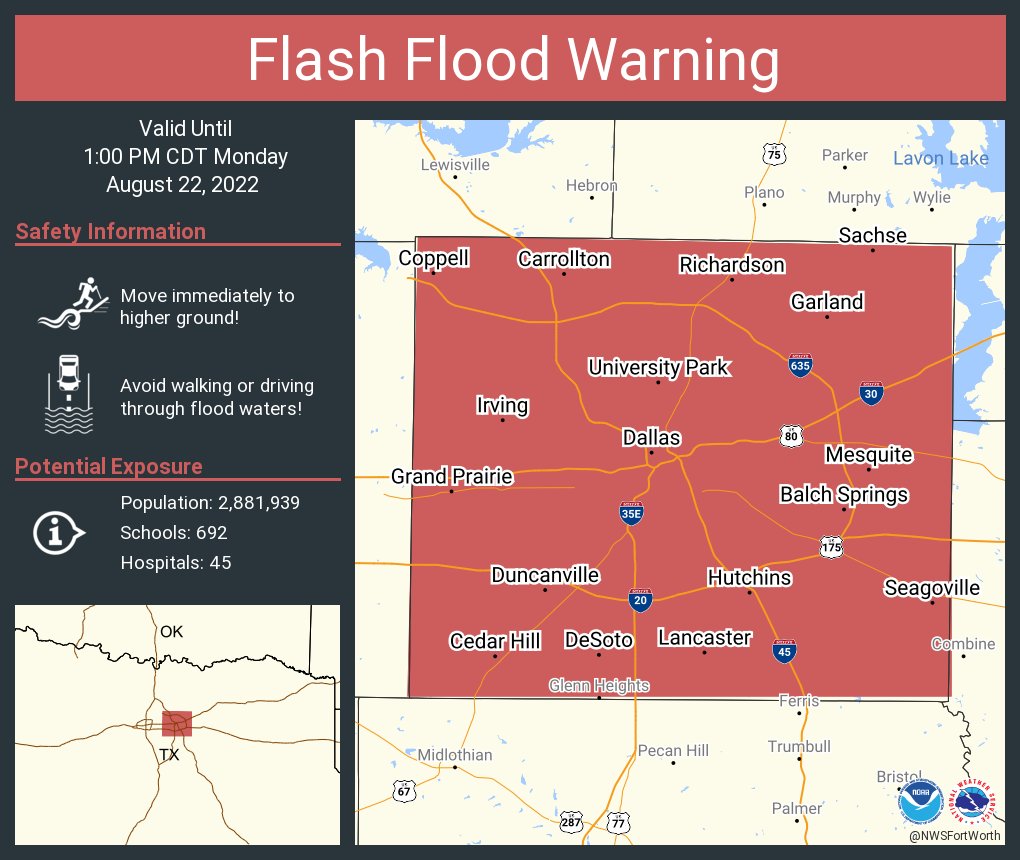
And DFW is getting drenched even more, a new Flash Flood Warning now has 10 inches fallen in Dallas County, and this has also popped up too.
FLASH FLOOD DAMAGE THREAT...CONSIDERABLE
0 likes
Bill 2015 & Beta 2020
Winter 2020-2021
All observations are in Tecumseh, OK unless otherwise noted.
Winter posts are focused mainly for Oklahoma & Texas.
Take any of my forecasts with a grain of salt, refer to the NWS, SPC, and NHC for official information
Never say Never with weather! Because ANYTHING is possible!
Winter 2020-2021
All observations are in Tecumseh, OK unless otherwise noted.
Winter posts are focused mainly for Oklahoma & Texas.
Take any of my forecasts with a grain of salt, refer to the NWS, SPC, and NHC for official information
Never say Never with weather! Because ANYTHING is possible!
-
bubba hotep
- S2K Supporter
- Posts: 6013
- Joined: Wed Dec 28, 2016 1:00 am
- Location: Collin County Texas
Re: Texas Summer 2022
New warning for DFW
0 likes
Winter time post are almost exclusively focused on the DFW area.
Return to “USA & Caribbean Weather”
Who is online
Users browsing this forum: Google [Bot], Gotwood, Killjoy12, rwfromkansas, Stratton23, TomballEd and 208 guests