You know the forecast is confusing when you post two different pictures of models... And have your Facebook fans vote which one they think will happen.
I know models are important, but don't meteorologists use other tools? Seems like the TV weather people are hooked on models.
If you're wondering, it's a meteorologist at KEYE. And either we will get a little rain tomorrow or we need to rent an ark.
Texas Spring-2015
Moderator: S2k Moderators
Forum rules

The posts in this forum are NOT official forecast and should not be used as such. They are just the opinion of the poster and may or may not be backed by sound meteorological data. They are NOT endorsed by any professional institution or STORM2K.
Re: Texas Spring-2015
0 likes
-
Rgv20

- S2K Supporter

- Posts: 2466
- Age: 39
- Joined: Wed Jan 05, 2011 5:42 pm
- Location: Edinburg/McAllen Tx
Lets see how the short range models verify...
0z4kNAM Simulated Radar forecast a line of Thunderstorms ready to cross the river by mid morning tomorrow..
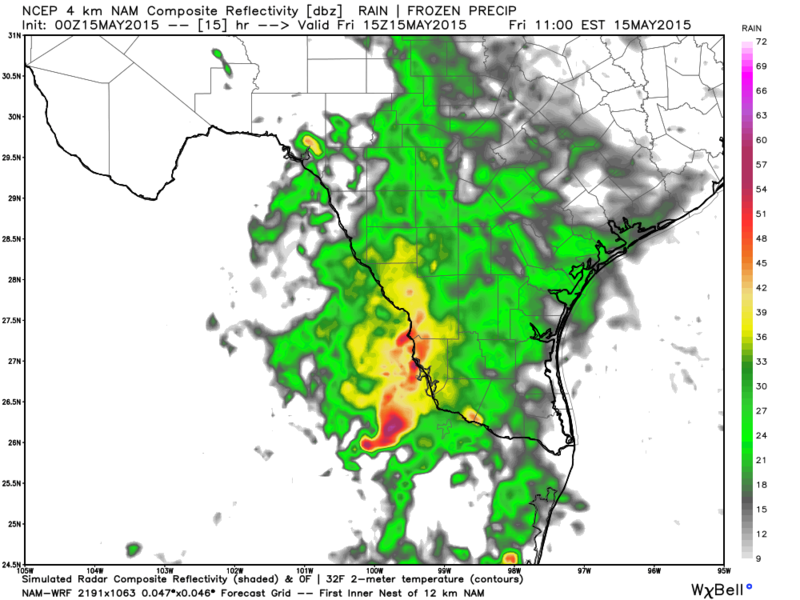
0zWRF Simulated Radar is more aggressive developing a squall line ready to cross the river early in the morning..
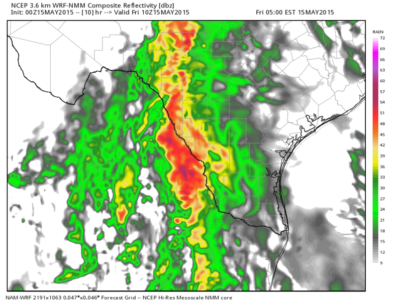
0z4kNAM Simulated Radar forecast a line of Thunderstorms ready to cross the river by mid morning tomorrow..

0zWRF Simulated Radar is more aggressive developing a squall line ready to cross the river early in the morning..

0 likes
The following post is NOT an official forecast and should not be used as such. It is just the opinion of the poster and may or may not be backed by sound meteorological data. It is NOT endorsed by any professional institution including storm2k.org For Official Information please refer to the NHC and NWS products.

Lake Texoma is now a little over 14 feet above flood stage or roughly 631 ft above sea level. Only 7 ft away from matching 2007's flooding event there which happened in July. 7 feet may seem a lot but at the pace the lake is rising it wouldn't take much longer now.
MCS kind of collapsed overnight out west and was a dud but storms are popping up around here. Hit or miss. Lawns in Dallas and Rockwall counties should be getting some good rains. It's been a great year for gardeners, just plant and sit back, relax, and the skies does the work.
MCS kind of collapsed overnight out west and was a dud but storms are popping up around here. Hit or miss. Lawns in Dallas and Rockwall counties should be getting some good rains. It's been a great year for gardeners, just plant and sit back, relax, and the skies does the work.
0 likes
The above post and any post by Ntxw is NOT an official forecast and should not be used as such. It is just the opinion of the poster and may or may not be backed by sound meteorological data. It is NOT endorsed by any professional institution including Storm2k. For official information, please refer to NWS products.
Help support Storm2K!
-
gboudx

- S2K Supporter
- Posts: 4090
- Joined: Thu Sep 04, 2003 1:39 pm
- Location: Rockwall, Tx but from Harvey, La
Re: Texas Spring-2015
Here's an article from the Dallas Morning News about the wet weather and lake levels. The article does include some statewide discussion as well.
0 likes
-
wxman57

- Moderator-Pro Met

- Posts: 23173
- Age: 68
- Joined: Sat Jun 21, 2003 8:06 pm
- Location: Houston, TX (southwest)
Re: Texas Spring-2015
I'm ready for some hot, DRY weather...
An occasional thunderstorm every few days is fine, but 5-10 inches per month (or per day) is a bit much.
An occasional thunderstorm every few days is fine, but 5-10 inches per month (or per day) is a bit much.
0 likes
-
weatherdude1108
- Category 5

- Posts: 4228
- Joined: Tue Dec 13, 2011 1:04 pm
- Location: Northwest Austin/Cedar Park, TX
Re: Texas Spring-2015
wxman57 wrote:I'm ready for some hot, DRY weather...
An occasional thunderstorm every few days is fine, but 5-10 inches per month (or per day) is a bit much.
Need to move the 5-10 inches per month (or per day) to the Highland Lakes watershed. I was reading that to get those lakes back to capacity, we need multiple rain events like this past Wednesday. There was an online chat with meteorologist Bob Rose of LCRA by the Austin Statesman. He said we need "many, many more rain events of that magnitude to get the two lakes back to capacity. The rains were generally between 1 and 2 inches; we need widespread totals of at least 10 to 15 inches."
0 likes
The preceding post is NOT an official forecast, and should not be used as such. It is only the opinion of the poster and may or may not be backed by sound meteorological data. It is NOT endorsed by any professional institution including storm2k.org. For Official Information please refer to the NHC and NWS products.
-
TeamPlayersBlue

- Category 5
- Posts: 3530
- Joined: Tue Feb 02, 2010 1:44 am
- Location: Denver/Applewood, CO
Re: Texas Spring-2015
weatherdude1108 wrote:wxman57 wrote:I'm ready for some hot, DRY weather...
An occasional thunderstorm every few days is fine, but 5-10 inches per month (or per day) is a bit much.
Need to move the 5-10 inches per month (or per day) to the Highland Lakes watershed. I was reading that to get those lakes back to capacity, we need multiple rain events like this past Wednesday. There was an online chat with meteorologist Bob Rose of LCRA by the Austin Statesman. He said we need "many, many more rain events of that magnitude to get the two lakes back to capacity. The rains were generally between 1 and 2 inches; we need widespread totals of at least 10 to 15 inches."
Problem is, it will likely get a couple REALLY big events to bring them close to normal. This type of pattern, its likely it could happen soon. Summer, im not so sure but till June, it could happen. With a true el nino expected to happen this winter, it should bring the lake up significantly, so maybe next year this time we could be at normal. I feel bad for all the residents on Travis.
0 likes
Personal Forecast Disclaimer:
The posts in this forum are NOT official forecast and should not be used as such. They are just the opinion of the poster and may or may not be backed by sound meteorological data. They are NOT endorsed by any professional institution or storm2k.org. For official information, please refer to the NHC and NWS products.
The posts in this forum are NOT official forecast and should not be used as such. They are just the opinion of the poster and may or may not be backed by sound meteorological data. They are NOT endorsed by any professional institution or storm2k.org. For official information, please refer to the NHC and NWS products.
Euro weeklies show rainfall across Texas to continue strong through the first two weeks of June. Not just a little but a lot above normal. Wettest area relative to normal across the states. Areas that have been rained on a lot are going to get much more.
Per ryan maue some members show in excess of 20 inches in the span of those 4 weeks for some
OLR anomalies show clear the hose from the central and eastern Pacific into Texas.
Per ryan maue some members show in excess of 20 inches in the span of those 4 weeks for some
OLR anomalies show clear the hose from the central and eastern Pacific into Texas.
0 likes
The above post and any post by Ntxw is NOT an official forecast and should not be used as such. It is just the opinion of the poster and may or may not be backed by sound meteorological data. It is NOT endorsed by any professional institution including Storm2k. For official information, please refer to NWS products.
Help support Storm2K!
Help support Storm2K!
-
WeatherNewbie
- Tropical Storm

- Posts: 235
- Joined: Mon Mar 22, 2010 3:42 pm
- Location: Richardson, Texas
Re: Texas Spring-2015
wxman57 wrote:I'm ready for some hot, DRY weather...
An occasional thunderstorm every few days is fine, but 5-10 inches per month (or per day) is a bit much.
After the drought and all the dead trees, I will never have this perspective.
0 likes
The above post is NOT an official forecast and should not be used as such. It is just the opinion of the poster and may or may not be backed by sound meteorological data. It is NOT endorsed by any professional institution including storm2k.org. For official information, please refer to NWS products.
-
TheProfessor

- Professional-Met

- Posts: 3506
- Age: 29
- Joined: Tue Dec 03, 2013 10:56 am
- Location: Wichita, Kansas
Re:
Ntxw wrote:Euro weeklies show rainfall across Texas to continue strong through the first two weeks of June. Not just a little but a lot above normal. Wettest area relative to normal across the states. Areas that have been rained on a lot are going to get much more.
Per ryan maue some members show in excess of 20 inches in the span of those 4 weeks for some
OLR anomalies show clear the hose from the central and eastern Pacific into Texas.
My goodness if that verified some people will have seen a year's worth of rain in 5 and a half months.
0 likes
An alumnus of The Ohio State University.
Your local National Weather Service office is your best source for weather information.
Your local National Weather Service office is your best source for weather information.
-
TheProfessor
- Professional-Met
- Posts: 3506
- Age: 29
- Joined: Tue Dec 03, 2013 10:56 am
- Location: Wichita, Kansas
By the way, today is the 2 year anniversary of the May 15, 2013 tornadoes. If I remember correctly there wasn't supposed to be any severe weather that day, much less tornadoes, we needed up getting 19 total. And none of them hit the for main DFW counties! It's days like those though that show you tornadoes can occur anytime anywhere.
0 likes
An alumnus of The Ohio State University.
Your local National Weather Service office is your best source for weather information.
Your local National Weather Service office is your best source for weather information.

-
Texas Snowman

- Storm2k Moderator

- Posts: 6197
- Joined: Fri Jan 25, 2008 11:29 am
- Location: Denison, Texas
Today is the anniversary of the F5 tornado that devastated Sherman here in Grayson County.
The tornado hit on Friday, May 15 about 5 p.m. and more than 60 of the 73 fatalities came as the tornado barreled through a portion of Sherman (it changed direction from its northeasterly course, moving north as it went through Sherman, causing it to miss the downtown area).
Here is the account via Wikipedia:
On the first day of the outbreak sequence, most of the fatalities came from a single supercell thunderstorm that traveled from Denton to Sherman. The tornado began in the Pilot Point area, where farm homes were shifted off of their foundations. The tornado widened and strengthened into a very violent F5 and swept away numerous farms west of Farmington and Howe. Later along the path, the tornado narrowed to around 60 yards (180 ft) wide as it tore through Sherman. Fifty homes were destroyed in town, 20 of which were completely obliterated and swept away. An iron-beam bridge was torn from its supports and twisted into multiple pieces, and one of the beams was driven several feet into the ground.[6][9] Bodies were found up to 400 yards (1,200 ft) from their home sites, and a trunk lid was carried for 35 miles (56 km). Headstones at a cemetery were shattered, and a 500-pound stone was carried for 250 yards. Trees in the area were completely debarked with some reduced to stumps, and grass was scoured from lawns in town.[9] At least 200 people were injured, and bodies of the victims were transported into the courthouse and a vacant building. Several bodies were recovered from a muddy creek.[10] Seventy-three people were killed by this single tornado, one of the worst on record in North Texas and the Red River Valley region."
0 likes
The above post and any post by Texas Snowman is NOT an official forecast and should not be used as such. It is just the opinion of the poster and may or may not be backed by sound meteorological data. It is NOT endorsed by any professional institution including storm2k.org. For official information, please refer to NWS products.
-
Texas Snowman
- Storm2k Moderator
- Posts: 6197
- Joined: Fri Jan 25, 2008 11:29 am
- Location: Denison, Texas
Another couple of snippets from the storm, as recorded on http://www.extremeplanet.me:
"One of the bodies was found in a tree four blocks from a home that was swept completely away. The ground within the streak of devastation was scoured, and an iron bridge on Houston Street was ripped from is anchor bolts and fragmented into “useless scraps.”
http://extremeplanet.me/tag/sherman-tornado-1896/
0 likes
The above post and any post by Texas Snowman is NOT an official forecast and should not be used as such. It is just the opinion of the poster and may or may not be backed by sound meteorological data. It is NOT endorsed by any professional institution including storm2k.org. For official information, please refer to NWS products.

-
TheProfessor
- Professional-Met
- Posts: 3506
- Age: 29
- Joined: Tue Dec 03, 2013 10:56 am
- Location: Wichita, Kansas
More pictures of the flooding behind my school.


I don't know where the water is coming from, I don't think it's from rain just falling over that area though it could be. It looks like it might stretch all the way and connect to lake grapevine but I'd have to walk along it to verify.
I don't know where the water is coming from, I don't think it's from rain just falling over that area though it could be. It looks like it might stretch all the way and connect to lake grapevine but I'd have to walk along it to verify.
0 likes
An alumnus of The Ohio State University.
Your local National Weather Service office is your best source for weather information.
Your local National Weather Service office is your best source for weather information.
Re:
EF-5bigj wrote:You guys in Texas are getting drought relief in the most extreme and destructive manner. The drenching you guys are getting makes most Mississippi frog stranglers look small.
It's life in the Great Plains. Everything is always on the extreme, too much or too little of something. If we're not in a flood, we're in drought. One end of the state might be at -1 while the other end it's 99 in winter. We have a desert (trans pecos Chihuahuan Desert) on the west side of the state and a forest (Piney woods) on the other end. That is why we always complain we get too much or too little of stuff
0 likes
The above post and any post by Ntxw is NOT an official forecast and should not be used as such. It is just the opinion of the poster and may or may not be backed by sound meteorological data. It is NOT endorsed by any professional institution including Storm2k. For official information, please refer to NWS products.
Help support Storm2K!
Help support Storm2K!
-
weatherdude1108
- Category 5
- Posts: 4228
- Joined: Tue Dec 13, 2011 1:04 pm
- Location: Northwest Austin/Cedar Park, TX
Re: Re:
Ntxw wrote:EF-5bigj wrote:You guys in Texas are getting drought relief in the most extreme and destructive manner. The drenching you guys are getting makes most Mississippi frog stranglers look small.
It's life in the Great Plains. Everything is always on the extreme, too much or too little of something. If we're not in a flood, we're in drought. One end of the state might be at -1 while the other end it's 99 in winter. We have a desert (trans pecos Chihuahuan Desert) on the west side of the state and a forest (Piney woods) on the other end. That is why we always complain we get too much or too little of stuff
He nailed it. Could not have sat it better.
Adding to that, Lubbock, TX receives normally 18.6 inches of rain a year. Austin, TX receives 33 inches a year on average.
They said on the news that Lubbock, TX has received more rain in May than Austin, TX has (around 7 inches in Lubbock versus around 6 inches in Austin).
0 likes
The preceding post is NOT an official forecast, and should not be used as such. It is only the opinion of the poster and may or may not be backed by sound meteorological data. It is NOT endorsed by any professional institution including storm2k.org. For Official Information please refer to the NHC and NWS products.
Return to “USA & Caribbean Weather”
Who is online
Users browsing this forum: snownado and 256 guests