Florida Weather
Moderator: S2k Moderators
Forum rules

The posts in this forum are NOT official forecast and should not be used as such. They are just the opinion of the poster and may or may not be backed by sound meteorological data. They are NOT endorsed by any professional institution or STORM2K.
Re: Florida Weather
Oh yes. There's lots of winter left. And I will admit I enjoy the hoodie weather too!
1 likes
-
northjaxpro

- S2K Supporter

- Posts: 8900
- Joined: Mon Sep 27, 2010 11:21 am
- Location: Jacksonville, FL
Re: Florida Weather
psyclone wrote:Oh yes. There's lots of winter left. And I will admit I enjoy the hoodie weather too!
OK. We have a truce
The cold will be back Psyclone (my fingers crossed)
Looks like I may see our second measured freeze here at my home station in the morning, btw. So this may be the last shot at a freeze for a little while for sure.
0 likes
NEVER, EVER SAY NEVER in the tropics and weather in general, and most importantly, with life itself!!
________________________________________________________________________________________
Fay 2008 Beryl 2012 Debby 2012 Colin 2016 Hermine 2016 Julia 2016 Matthew 2016 Irma 2017 Dorian 2019
________________________________________________________________________________________
Fay 2008 Beryl 2012 Debby 2012 Colin 2016 Hermine 2016 Julia 2016 Matthew 2016 Irma 2017 Dorian 2019
-
gatorcane

- S2K Supporter
- Posts: 23708
- Age: 48
- Joined: Sun Mar 13, 2005 3:54 pm
- Location: Boca Raton, FL
Re: Florida Weather
There are signs in the long-range GFS the cold is coming. This year reminds me a bit of 2009-2010 winter (or was it 2010-2011?) where we were warm in December but then wham, January was way below normal. But first let’s see what this weekend storm brings.
0 likes
-
northjaxpro
- S2K Supporter
- Posts: 8900
- Joined: Mon Sep 27, 2010 11:21 am
- Location: Jacksonville, FL
Re: Florida Weather
18Z GFS considerably weaker than the 12Z run and a bit farther north with the Gulf Low.
1007 mb being depicted by the 18Z GFS in Apalachee Bay
late Sunday aftermoon. GFS then moves the system across North and Northeast Florida Sunday night, then off the SC coast and GFS intensifes it to 999 mb by 06Z Monday morning.
1007 mb being depicted by the 18Z GFS in Apalachee Bay
late Sunday aftermoon. GFS then moves the system across North and Northeast Florida Sunday night, then off the SC coast and GFS intensifes it to 999 mb by 06Z Monday morning.
0 likes
NEVER, EVER SAY NEVER in the tropics and weather in general, and most importantly, with life itself!!
________________________________________________________________________________________
Fay 2008 Beryl 2012 Debby 2012 Colin 2016 Hermine 2016 Julia 2016 Matthew 2016 Irma 2017 Dorian 2019
________________________________________________________________________________________
Fay 2008 Beryl 2012 Debby 2012 Colin 2016 Hermine 2016 Julia 2016 Matthew 2016 Irma 2017 Dorian 2019
-
northjaxpro
- S2K Supporter
- Posts: 8900
- Joined: Mon Sep 27, 2010 11:21 am
- Location: Jacksonville, FL
Re: Florida Weather
Well, unlike on Dec. 3 here at my house, we did not get to the freeze mark this time. It bottomed out at 33F this morning, just missing out on getting another freeze here at my home. We had the wind from about 5 mph come about just before sunrise. We had calm wind until about 5: 00, but just that little mixing of wind kept the temp from reaching the freeze point here. There were spots across the region to reach at of slightly below freezing , especially just north and west of me this morning over in Baker County, and Columbia County, including Lake City, and up across the state line in Southeast Georgia. Jax Cecil Comerce area, always the coldest.locale pertaining to cold air drainage here in Duval County, checked in at 31 degrees.
Latest model still on track for major event for wind and potential heavy rain for the peninsula. GFS still calling for potential of wide spread 3-6 inches of rainfall with potential of higher amounts, especially over North and Northeast Florida, especially with Sunday and Sunday evening time period being when the heaviest rain occurs . The Low Pressure area is forecast by this morning's 06Z GFS run to be at 1004 mb as it crosses North Florida Sunday, but intensifies it to 998 mb as it emergizes just off the Northeast Florida coast by 06Z Monday.
00Z EURO is not nearly as wet as the GFS with the system as it is only showing 1-2 inch rainfall totals for the entire event through Monday.
Looking at the dynamics of this Low Pressure system, I have to believe the GFS has the better handling of this system as of right now.
Running a bit.late, gotta head out to work. Messy, stormy weekend ahead! More on this storm a bit later.
.Have a great day everyone!
0 likes
NEVER, EVER SAY NEVER in the tropics and weather in general, and most importantly, with life itself!!
________________________________________________________________________________________
Fay 2008 Beryl 2012 Debby 2012 Colin 2016 Hermine 2016 Julia 2016 Matthew 2016 Irma 2017 Dorian 2019
________________________________________________________________________________________
Fay 2008 Beryl 2012 Debby 2012 Colin 2016 Hermine 2016 Julia 2016 Matthew 2016 Irma 2017 Dorian 2019

Re: Florida Weather
gatorcane wrote:There are signs in the long-range GFS the cold is coming. This year reminds me a bit of 2009-2010 winter (or was it 2010-2011?) where we were warm in December but then wham, January was way below normal. But first let’s see what this weekend storm brings.
That was the winter of 2009-2010 which we had a warm first 3/4 of the month followed by a record breaking lows in January 2010.
Winter of 2010-2011 is when we had the coldest December on Record the whole peninsula, Dec '10.
0 likes
-
HurricaneBelle

- S2K Supporter
- Posts: 1209
- Joined: Sun Aug 27, 2006 6:12 pm
- Location: Clearwater, FL
Re: Florida Weather
Interesting tidbit regarding the weekend storm from the Tampa Bay AFD which just came out:
The rain, sometimes heavy, is a given, but the real question is going to be how much wind do we get out of this?
THE 6 AND 12Z GFS DEVELOPS A SHORT WAVE IN THE DEEP LAYER FLOW
WHICH MOVES OFF TO THE EAST ESSENTIALLY SPLITTING THE SURFACE LOW
IN HALF WITH PART OF THE LOW MOVING ACROSS THE STATE AND THE OTHER
HALF BUILDING NORTH WITH THE DEEP LAYER TROUGH. THIS SEEMS
UNLIKELY SO I TEND TO AGREE WITH A 00Z EURO SOLUTION WHICH
DEEPENS THE SURFACE LOW AND OCCLUDES IT. THE CORRECT SOLUTION WILL
HAVE A HUGE IMPACT ON OUR AREA AS THE GFS SOLUTION WILL HAVE A
MUCH TIGHTER GRADIENT CREATING NEAR GALE FORCE SOUTHEAST WINDS.
THE ECKMAN TRANSPORTS CAUSED BY THESE WINDS WILL LIKELY SEE SOME
COASTAL FLOODING LATE SATURDAY AND EARLY SUNDAY. THIS COULD
IMPACT DRAINAGE OF ANY HEAVY RAIN THAT WILL FALL ALSO. THE
HEAVIEST RAIN IS WITH THE SHORT WAVE GOING OVER THE STRONG
ISENTROPIC LIFT.
The rain, sometimes heavy, is a given, but the real question is going to be how much wind do we get out of this?
0 likes


Re: Florida Weather
HurricaneBelle wrote:Interesting tidbit regarding the weekend storm from the Tampa Bay AFD which just came out:THE 6 AND 12Z GFS DEVELOPS A SHORT WAVE IN THE DEEP LAYER FLOW
WHICH MOVES OFF TO THE EAST ESSENTIALLY SPLITTING THE SURFACE LOW
IN HALF WITH PART OF THE LOW MOVING ACROSS THE STATE AND THE OTHER
HALF BUILDING NORTH WITH THE DEEP LAYER TROUGH. THIS SEEMS
UNLIKELY SO I TEND TO AGREE WITH A 00Z EURO SOLUTION WHICH
DEEPENS THE SURFACE LOW AND OCCLUDES IT. THE CORRECT SOLUTION WILL
HAVE A HUGE IMPACT ON OUR AREA AS THE GFS SOLUTION WILL HAVE A
MUCH TIGHTER GRADIENT CREATING NEAR GALE FORCE SOUTHEAST WINDS.
THE ECKMAN TRANSPORTS CAUSED BY THESE WINDS WILL LIKELY SEE SOME
COASTAL FLOODING LATE SATURDAY AND EARLY SUNDAY. THIS COULD
IMPACT DRAINAGE OF ANY HEAVY RAIN THAT WILL FALL ALSO. THE
HEAVIEST RAIN IS WITH THE SHORT WAVE GOING OVER THE STRONG
ISENTROPIC LIFT.
The rain, sometimes heavy, is a given, but the real question is going to be how much wind do we get out of this?
Watching this here in Brooksville(hernando county).
0 likes
Robbielyn McCrary
I know just about enough to sound like I know what I'm talking about sometimes. But for your safety please follow the nhc for truly professional forecasting.
I know just about enough to sound like I know what I'm talking about sometimes. But for your safety please follow the nhc for truly professional forecasting.

Re: Florida Weather
HurricaneBelle wrote:Interesting tidbit regarding the weekend storm from the Tampa Bay AFD which just came out:THE 6 AND 12Z GFS DEVELOPS A SHORT WAVE IN THE DEEP LAYER FLOW
WHICH MOVES OFF TO THE EAST ESSENTIALLY SPLITTING THE SURFACE LOW
IN HALF WITH PART OF THE LOW MOVING ACROSS THE STATE AND THE OTHER
HALF BUILDING NORTH WITH THE DEEP LAYER TROUGH. THIS SEEMS
UNLIKELY SO I TEND TO AGREE WITH A 00Z EURO SOLUTION WHICH
DEEPENS THE SURFACE LOW AND OCCLUDES IT. THE CORRECT SOLUTION WILL
HAVE A HUGE IMPACT ON OUR AREA AS THE GFS SOLUTION WILL HAVE A
MUCH TIGHTER GRADIENT CREATING NEAR GALE FORCE SOUTHEAST WINDS.
THE ECKMAN TRANSPORTS CAUSED BY THESE WINDS WILL LIKELY SEE SOME
COASTAL FLOODING LATE SATURDAY AND EARLY SUNDAY. THIS COULD
IMPACT DRAINAGE OF ANY HEAVY RAIN THAT WILL FALL ALSO. THE
HEAVIEST RAIN IS WITH THE SHORT WAVE GOING OVER THE STRONG
ISENTROPIC LIFT.
The rain, sometimes heavy, is a given, but the real question is going to be how much wind do we get out of this?
What's interesting is that following my own review of this a.m.'s model runs, have begun to swing my thinking a bit closer to the EURO set-up of this low splitting (N.E./S.W.), with the main energy a bit further north and eventually associated with the stronger low developing east of Jax. If that scenario were to play out, then little significant wind would be felt near W. Coast Florida and the greatest beach erosion and threat of off-shore Gale force winds potentially ending up limited to perhaps Daytona northward. Seems as if the entire evolution is still quite fluid either way. BTW, from the 12Z EURO - looks like in spite of a more northern development of this surface feature, projections of highest total accumulation rainfall are being projected in the 5"-7" range in a swath from lower S.W. Florida coast to ENE across Lake 'O and towards the Vero/W. Palm area as depicted in link attached below (Geeez, if I could ONLY learn how to attach the link to posts here where the actual image is shown and NOT a link).
https://i.imgur.com/MVQ1KRV.png
1 likes
Andy D
(For official information, please refer to the NHC and NWS products.)
(For official information, please refer to the NHC and NWS products.)
Re: Florida Weather
WPC keeps nudging QPF max northward with time. That makes sense. over running isentropic lift FTW... probably favors heaviest rain over the TLH/JAX/CHS CWAs.
0 likes
-
SFLcane

- S2K Supporter
- Posts: 10281
- Age: 48
- Joined: Sat Jun 05, 2010 1:44 pm
- Location: Lake Worth Florida
Re: Florida Weather
0 likes
-
TheStormExpert
Re: Florida Weather
SFLcane wrote:40-50mph gusts across SFL... um no
https://twitter.com/weatherchannel/stat ... 75749?s=21
I'll gladly take the chillier weather over this for Christmas but you can't win down here!
1 likes
-
northjaxpro
- S2K Supporter
- Posts: 8900
- Joined: Mon Sep 27, 2010 11:21 am
- Location: Jacksonville, FL
Re: Florida Weather
psyclone wrote:WPC keeps nudging QPF max northward with time. That makes sense. over running isentropic lift FTW... probably favors heaviest rain over the TLH/JAX/CHS CWAs.
I agree. The warm front will slowly be creeping northward throughout this event as the Low Pressure system organizes in the GOM and advances eastward. The warm front should be directly over the North Florida area by Sunday evening. The heaviest rainfall potential will be that isentropic lift across North and Northeast Florida, Southern Georgia and up into the Low Country region of South Carolina late Sunday on through Monday afternoon. The Low is being progged at 1001 mb on the latest 18Z GFS to move off the Georgia coast by 06Z Monday morning.
This is still a very fluid situation with this developing storm as changes are still occuring with the model runs. We should have a much clearer idea hopefully from the models on this system and how it will shake down by the 12Z runs tomorrow for me.
No doubt we will have a very wet and stormy weekend across the entire peninsula, especially from Saturday evening right on through Sunday evening and early Monday.
.
0 likes
NEVER, EVER SAY NEVER in the tropics and weather in general, and most importantly, with life itself!!
________________________________________________________________________________________
Fay 2008 Beryl 2012 Debby 2012 Colin 2016 Hermine 2016 Julia 2016 Matthew 2016 Irma 2017 Dorian 2019
________________________________________________________________________________________
Fay 2008 Beryl 2012 Debby 2012 Colin 2016 Hermine 2016 Julia 2016 Matthew 2016 Irma 2017 Dorian 2019
Re: Florida Weather
Tampa NWS said I4 south will experience thunderstorms. the wind has decreased for our area as well only gusting to 25mph from earlier forecasts. I'm north of the I4 corridor. For our area 2-3 inches of rain but thunderstorms south of the I4. So just a soggy event in hernando county it looks like with strataform rain vs convection Saturday night into Sunday. However, convection south of I4 as well as potential for severe weather.
Update: Very little change other than, north of I4 corridor marginal excessive rainfall though hard to pinpoint which areas, and severe potential only in the most southern counties under tampa nws on Sunday. While there is sheer, the low aloft will be remaining behind so the cooler mid-level temperatures associated with it will be left behind as well.So severe potential not very high. Per Tampa NWS discussion 1256pm Friday.
Update: Very little change other than, north of I4 corridor marginal excessive rainfall though hard to pinpoint which areas, and severe potential only in the most southern counties under tampa nws on Sunday. While there is sheer, the low aloft will be remaining behind so the cooler mid-level temperatures associated with it will be left behind as well.So severe potential not very high. Per Tampa NWS discussion 1256pm Friday.
Last edited by robbielyn on Fri Dec 20, 2019 1:11 pm, edited 1 time in total.
0 likes
Robbielyn McCrary
I know just about enough to sound like I know what I'm talking about sometimes. But for your safety please follow the nhc for truly professional forecasting.
I know just about enough to sound like I know what I'm talking about sometimes. But for your safety please follow the nhc for truly professional forecasting.
Re: Florida Weather
The GFS in its 72-120 hr forecast period forecasting a wet Saturday for most of FL busted big time, tomorrow will be a nice day as forecasted correctly by the Euro within its 120 hr forecast.

0 likes
-
gatorcane
- S2K Supporter
- Posts: 23708
- Age: 48
- Joined: Sun Mar 13, 2005 3:54 pm
- Location: Boca Raton, FL
Re: Florida Weather
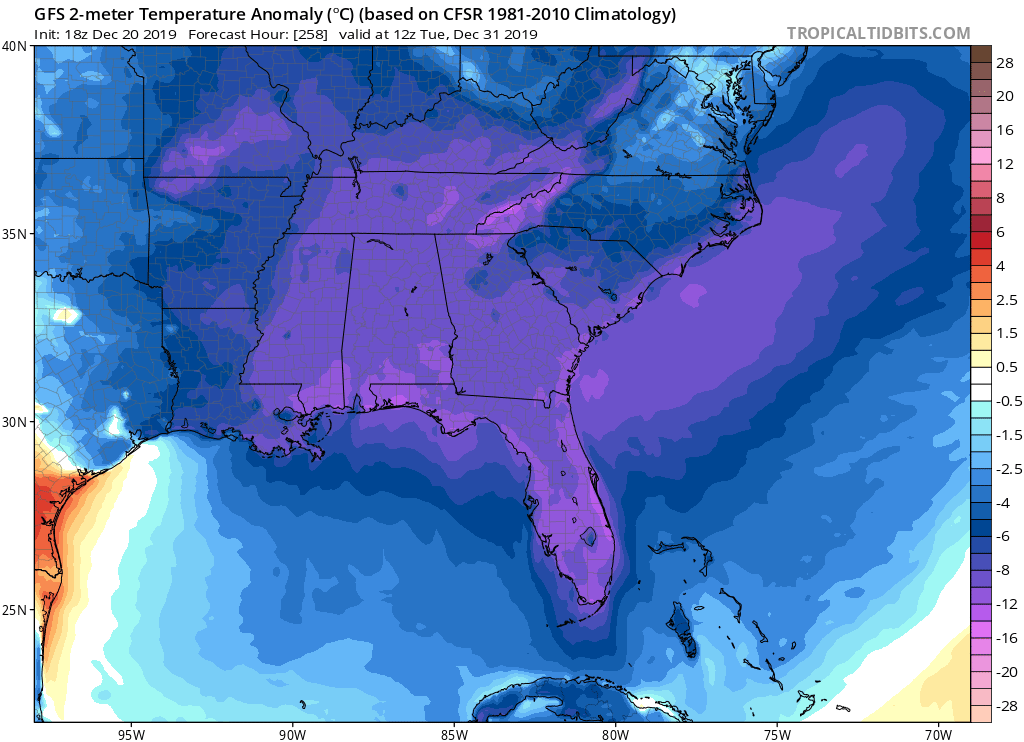
Medium to long-range GFS is trending the past several runs with a weaker and more transient SE US ridge and stronger troughing which looks to bring below normal temps to Florida after a period of several days next week and into next weekend with above normal temps statewide. Let’s see if it keeps trending colder. Looks like 30s and 40s for the peninsula.
0 likes
Re: Florida Weather
When isn't the GFS showing colder times ahead. It's a baseline state...or at least it seems like it. We're going to end December having avoided any severe cold. For peninsular florida that's a third of the freeze season in the can. After we dispose of the weekend weather event, the Christmas to New Year's timeframe looks nice here.
0 likes
-
TheStormExpert
Re: Florida Weather
The GFS is useless beyond 5-7 days as we’ve seen during hurricane season and even with cold fronts in the winter months. Though the NAO is forecasted in two weeks to go negative with a positive PNA this go round so it may be onto something.
0 likes
-
northjaxpro
- S2K Supporter
- Posts: 8900
- Joined: Mon Sep 27, 2010 11:21 am
- Location: Jacksonville, FL
Re: Florida Weather
Yeah, GFS missed on the wram front placement in earlier runs through 120 hours. A strong coastal trough developed early today and has brought about a very moist and strong onshore fetch along the Northeast Florida Coast and will continue to do so for the next 24-48 hours. This will delay the warm sector from advancing north during Saturday. The inverted trough will morph as a warm front by 06Z Sunday morning, which indeed caused a significant change in tomorrow's forecast to widely scattered showers.mainy on the strong easterly to southeasterly flow to be felt well into tomorrow and into tomorrow night across the peninsula.
Now NDG , I would not go as far as saying it will be a nice day tomorrow, relatively speaking, but it probably will not be a complete washout as initially shown in the 120 hr GFS timeframe. The strong easterly fetch has already brought rain here across Jax area today, and ample moisture from the Atlantic.will bring scattered rain showers moving onshore at times and across down state during the day tomorrow. I still believe the GFS overall will be closer to being right on its rainfall projections of up to 3-6 inches in most areas, especially across North Florida Sunday afternoon through the end of the event by late Tuesday. Earlier EURO runs did not have this system being nearly as wet, showing 1-2 inch totals generally across the region 36 hours ago. GFS has not been terrible with this at all overall with the handling of this system ìmo, other than missing earlier in the week on tomorrow's 120 hr forecast with the placement of the warm front.
Once the Low Pressure area organizes in the NE GOM on Sunday afternoon, the warm front should be across the North Florida to North-Central peninsula region by early Sunday evening. The time frame from mid-morning Sunday through into early Monday morming.is when the potential of heaviest rainfall and strong storms will occur as strong isentropic lifting (overrunning) will take place along and to the north of the warm front boundary as it lifts north.
The other thing to watch will be as the Low Pressure area moves off shore the Georgia coast and attempts to intensify early Monday, winds will.pick up from the northwest to north on the backside of the system and could bring wind gusts in the 30 mph range or higher gusts across the region during Monday. Rain and a few storms looks to linger across the region as well as a strong closed mid-upper Low coming from Florida panhandle moves directly over North Florida Monday and Monday evening. It is looking like this storm system will finally be out of our hair hopefully by early Christmas Eve afternoon (Tuesday afternoon).
0 likes
NEVER, EVER SAY NEVER in the tropics and weather in general, and most importantly, with life itself!!
________________________________________________________________________________________
Fay 2008 Beryl 2012 Debby 2012 Colin 2016 Hermine 2016 Julia 2016 Matthew 2016 Irma 2017 Dorian 2019
________________________________________________________________________________________
Fay 2008 Beryl 2012 Debby 2012 Colin 2016 Hermine 2016 Julia 2016 Matthew 2016 Irma 2017 Dorian 2019

Return to “USA & Caribbean Weather”
Who is online
Users browsing this forum: No registered users and 94 guests