Florida Weather
Moderator: S2k Moderators
Forum rules

The posts in this forum are NOT official forecast and should not be used as such. They are just the opinion of the poster and may or may not be backed by sound meteorological data. They are NOT endorsed by any professional institution or STORM2K.
Re: Florida Weather
Standard issue winter cool snap on the way. Hoodie and slow cooker on standby.
0 likes
-
SFLcane

- S2K Supporter

- Posts: 10281
- Age: 48
- Joined: Sat Jun 05, 2010 1:44 pm
- Location: Lake Worth Florida
Re: Florida Weather
AFD Miami:
“It is important to note that model runs continue to get cooler with the temperatures, and some models are even hinting at a freeze for areas near the Lake Region. Since this is at the end of the forecast period, the forecast itself is still highly uncertain at this time. , lingering moisture over the Atlantic waters combined with surface winds will allow for the continued development of rain showers across the Atlantic coastline and adjacent waters of South Florida. High pressure takes control Wednesday.
“It is important to note that model runs continue to get cooler with the temperatures, and some models are even hinting at a freeze for areas near the Lake Region. Since this is at the end of the forecast period, the forecast itself is still highly uncertain at this time. , lingering moisture over the Atlantic waters combined with surface winds will allow for the continued development of rain showers across the Atlantic coastline and adjacent waters of South Florida. High pressure takes control Wednesday.
0 likes


-
northjaxpro

- S2K Supporter
- Posts: 8900
- Joined: Mon Sep 27, 2010 11:21 am
- Location: Jacksonville, FL
Re: Florida Weather
For the third consecutive day this week, a record maximum temperature record was set at the National Weather Service office here in Jacksonville with 83 degrees for the second straight day. Monday's max temp was 84F. All records for the dates.
This has been just an incredible period of record warmth over the Northeast Florida region thanks to the + NAO and its subsequent anomalously strong ridge, which has dominated the weather story for much of this supposed meteorological winter season once again, and will hang around for one more day across the region. Tomorrow's record maximum is 84F. The forecast high is 82F. Clouds and showers out ahead of a cold front dropping rapidly south/southeast from the Plains is forecast to move through the North Florida region tomorrow afternoon, bringing clouds and scattered rain showers. This probably should keep the area from reaching the record max for tomorrow. It still will be a close call.
The blow torch ridge will FINALLY relinquish its grip over the area and Old Man Winter is finally about to make some sort of appearance this season for the Eastern CONUS beginning in earnst on late Sunday evening. A very strong 1049 mb Polar High is forecast drop down from Canada into Minnesota by 18Z tomorrow afternoon. Due to the PNA still currently in its negative phase, this High will maintain its progressive eastward movement across the Great Lakes to Maine by Saturday afternoon. The front will cool us back down to near seasonal norms into the 60s for max temps in Jax in response on Friday with breezy, onshore winds bringing cooler temps. The Big Polar High will move off the U.S. Eastern seaboard, bringing return flow and moisture back across the area and the peninsula for Sunday into Sunday evening just ahead of the next strong cold front.
As Gatorcane and others earlier pointed out, the latest model guidance indeed have turned significantly colder with the next cold intrusion on the way beginning Monday. Both the GFS and EURO really amplify the 500 mb upper trough across the Eastern CONUS beginning Monday and continually through Wednesday morning. The PNA index turns positive, beginning on Sunday, which as the daily teleconnections are now forecast to be indicating, which corresponds to the upcoming strong 1049 mb Polar High on tonight's 00Z GFS run. This HP coming down into the Northern Plains on Monday will drop south toward the Deep South region and be centered over Northern AL/GA by Wednesday morning, thus bringing possibly the coldest air of this season thus far into the region early next week. Tonight's 00Z EURO has the Polar High dropping into the Central Plains, but not quite as strong as the GFS, with 1043 mb centered over Iowa by 00Z Tuesday. 00z EURO shows mid-upper 20s panhandle, upper 20s to lower 30s interior North Florida, and mainly lower 30s Jax area . 00Z EURO this evening shows generally upper 30s to Lower 40s across Central Peninsula this run and generally 45-50F interior South Florida peninsula areas. We will see if EURO will trend colder to what the 00Z GFS showed on their run this evening.
Current projections from GFS ensembles are calling potentially for a Hard Freeze over portions of the Panhandle and northern Florida peninsula on Tuesday and Wednesday mornings of this upcoming week. Tonight's 00Z GFS run is indicating low to mid 20s across areas of the Florida panhandle, mid to upper 20s Big Bend region and the Suwannee River Valley region , and upper 20s to near 30 degrees in and around the Greater Jax metro area. GFS has the freezing line cutting right across North Central peninsula areas from a line extending from the Nature Coast region around Brooksville eastward to Leesburg to Daytona on Tuesday morning. Temps in the mid 30s across the I-4 corridor and over much of East Central Florida peninsula. The 00Z EURO run tonight temps are being shown to drop into the lower 40s across most of South Central Florida and mid-upper 40s in South Florida.
So, if the trends continue to colder with the models, we look to be in store for potentially the coldest weather we have seen in a long time in these parts early next week. Again, to give perspective about this, since January 2018, I have only measured a total of only 4 days of temps at or below freezing here at my home station. There has not been a single day measured below 30 degrees at my home locale since January 5, 2018, which was on the heels of that memorable Southeast Georgia/SC winter storm that brought 28 degrees that morning here. It has been more than 2 years since we have seen temperatures as cold as what is being projected by tonight's 00Z GFS for Tuesday and Wednesday morning of next week for the Northern Florida peninsula.
We will see if the models keep the colder trends going tomorrow into Friday.
0 likes
NEVER, EVER SAY NEVER in the tropics and weather in general, and most importantly, with life itself!!
________________________________________________________________________________________
Fay 2008 Beryl 2012 Debby 2012 Colin 2016 Hermine 2016 Julia 2016 Matthew 2016 Irma 2017 Dorian 2019
________________________________________________________________________________________
Fay 2008 Beryl 2012 Debby 2012 Colin 2016 Hermine 2016 Julia 2016 Matthew 2016 Irma 2017 Dorian 2019

Re: Florida Weather
While the GFS trended colder during the past few runs the Euro continues to trend warmer for both Tuesday and Wednesday morninngs for central and southern FL with freezing temps only to the Nature Coast at the most, as usual.
The Euro now shows SE FL no lower than lower 50s for lows.
Tuesday Morning lows:
GFS

Euro

Wednesday morning lows:
GFS

Euro

The Euro now shows SE FL no lower than lower 50s for lows.
Tuesday Morning lows:
GFS
Euro
Wednesday morning lows:
GFS
Euro
0 likes


Re: Florida Weather
For the first time in quite a while it looks like the NAO will be tanking after this week. I’ll take any cooler weather at this point even if it’s the 50s, it sure better than a low a 75 in January
https://www.cpc.ncep.noaa.gov/products/ ... /nao.shtml
https://www.cpc.ncep.noaa.gov/products/ ... /nao.shtml
0 likes
Re: Florida Weather
NWS has dropped the highs on Tuesday here into the upper 50's...that's aggressive this far out.
0 likes
-
northjaxpro
- S2K Supporter
- Posts: 8900
- Joined: Mon Sep 27, 2010 11:21 am
- Location: Jacksonville, FL
Re: Florida Weather
I have been discussing this some over in the Texas Weather thread with some of the Storm2K posters over there, and like I mentioned on that thread, we need a significant tanking of the NAO to help build the Greenland Blocking pattern to bring the coldest anomalies southward into the Eastern CONUS . It is common or has been precedent to see the Greenland Block form during a - NAO and we await to see if this all will happen this time. It has been so so long that we have seen a negative NAO set up in this time of year. Will we see this incredible nearly decade long streak of not having a - NAO during meteorological winter FINALLY come to an end?
I have to see it to believe it!
1 likes
NEVER, EVER SAY NEVER in the tropics and weather in general, and most importantly, with life itself!!
________________________________________________________________________________________
Fay 2008 Beryl 2012 Debby 2012 Colin 2016 Hermine 2016 Julia 2016 Matthew 2016 Irma 2017 Dorian 2019
________________________________________________________________________________________
Fay 2008 Beryl 2012 Debby 2012 Colin 2016 Hermine 2016 Julia 2016 Matthew 2016 Irma 2017 Dorian 2019
-
TheStormExpert
Re: Florida Weather
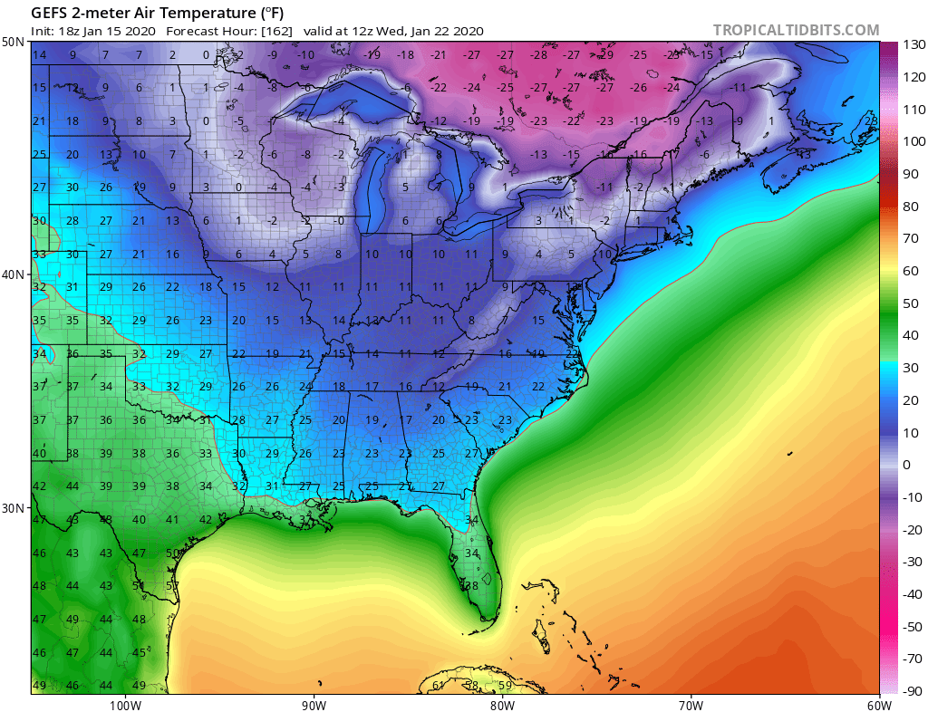
NDG wrote:While the GFS trended colder during the past few runs the Euro continues to trend warmer for both Tuesday and Wednesday morninngs for central and southern FL with freezing temps only to the Nature Coast at the most, as usual.
The Euro now shows SE FL no lower than lower 50s for lows.
Tuesday Morning lows:
GFS
https://i.imgur.com/mLuD2fM.png
Euro
https://i.imgur.com/6mYrmBS.png
Wednesday morning lows:
GFS
https://i.imgur.com/3cF7mi4.png
Euro
https://i.imgur.com/MOsYdzQ.png
50’s for lows here in SE Florida is cold enough for me! Besides that pretty impressive I guess considering that winters have been trending overall warmer for Florida for nearly a decade now.
Before you know it we’ll be lucky to get even one decent cold front each winter season here!

0 likes
Re: Florida Weather
We had one cool snap around Thanksgiving and one coming up next week but let’s see if this will be it or we get a few more because like storm expert said it’s harder to get cold fronts down here now.
0 likes
Re: Florida Weather
Here's some encouragement for warm weather fans on the board (all none of them)
A.) Winter is half over.
B.) The days are getting longer
C.) Averages will begin their seasonal increase soon
D.) There's no snowcover up north
E.) shelf water temps around peninsular Florida are 70 degrees or warmer. Temps this warm will force a meaningful modification of cold air for coastal locations. It's a get out of jail free card in the event things get crazy
F.) It's 80 right now
G.) My car is covered in pine pollen and azaleas are blooming. Nature has already advanced into spring
H.) The coming cold spell is legit but will it be memorable 3 years from now? I'd bet heavily on no. Odds favor no significant freezes
I.) Bet with persistence which = bet against significant cold. With few exceptions all anomalous weather over the past decade has been warm
*Full disclosure* This post is constructed on a foundation of facts, logic and shameless -removed-.
0 likes
-
TheStormExpert
Re: Florida Weather
So enjoy whatever cooler and less humid weather we can get while it’s here.
Btw SST’s are most definitely warmer than average off our coasts for this time of year. It’s currently in the mid-upper 70’s to even 80° in the portion of the GulfStream in between Eastern Palm Beach County and West End, Grand Bahama.

0 likes
Re: Florida Weather
I will definitely enjoy the chill. In fact I find myself cheering late season cool snaps as we head toward and into spring. Cool weather under an increasingly potent sun angle is a great combo
0 likes
Re: Florida Weather
I was going to mention that, those SSTs are going to make it really difficult for a cold snap that I'll talk about 5 years from now to occur. Low 50s for the SE coast seems reasonable. Plus, simply having a NAO- doesn't necessarily guarantee that we're getting record breaking cold.
If the NAO does indeed tank, I'll be curious to see if the cool we do get sticks around for a little longer. With those water temps, probably not....
If the NAO does indeed tank, I'll be curious to see if the cool we do get sticks around for a little longer. With those water temps, probably not....
0 likes
-
TheStormExpert
Re: Florida Weather
Patrick99 wrote:I was going to mention that, those SSTs are going to make it really difficult for a cold snap that I'll talk about 5 years from now to occur. Low 50s for the SE coast seems reasonable. Plus, simply having a NAO- doesn't necessarily guarantee that we're getting record breaking cold.
If the NAO does indeed tank, I'll be curious to see if the cool we do get sticks around for a little longer. With those water temps, probably not....
Those warm SST’s are due to a lack of cold fronts this season. If the NAO does indeed go negative next month(which I have doubts) it’ll more than likely put a dent in the SST’s depending on the strength and duration of the cooler or colder weather.
0 likes
-
TheStormExpert
Re: Florida Weather
boca wrote:We had one cool snap around Thanksgiving and one coming up next week but let’s see if this will be it or we get a few more because like storm expert said it’s harder to get cold fronts down here now.
I can guarantee you that global warming is playing a HUGE role in all of this, but that’s a topic for another place.
0 likes
Re: Florida Weather
I’m going to New York City for a few days and they haven’t had a winter storm watch or warning this whole season yet so global warming is in play here just like the lack of cold fronts for us here. At least I’ll experience 30 degrees for 4 days which will feel great compared to 82 degrees every single day. Yes the warm weather gets old for those that think I’m crazy.
1 likes

Re: Florida Weather
boca wrote:I’m going to New York City for a few days and they haven’t had a winter storm watch or warning this whole season yet so global warming is in play here just like the lack of cold fronts for us here. At least I’ll experience 30 degrees for 4 days which will feel great compared to 82 degrees every single day. Yes the warm weather gets old for those that think I’m crazy.
When are ya going? New York city get's their bulk of Winter weather late January & February. I'm pretty sure you'll get your watches & warnings if you're up there beween the 26th - 30th.
0 likes
Andy D
(For official information, please refer to the NHC and NWS products.)
(For official information, please refer to the NHC and NWS products.)
Re: Florida Weather
My latest forecast (nws) has 3 days of below normal temps (Monday through Wednesday) with Tuesday being the coldest averaging about 10 degrees below normal. Considering we have been routinely 10+ above normal this is going to be a big change but it will be brief as temps rebound to normal by next Thursday. The lowest temp as of now is 40 so we have plenty of wiggle room wrt to freezing temps here. The latest 6-10 and 8-14 day outlooks show normalish conditions which would translate to weather a good bit cooler than what we have been experiencing. Longer range expectations of cold are getting wobbly and I've seen some cliff jumping among the winter lovers on other forums but we know better than to bank on ultra long range cold...too many fake outs. There is still time for winter to sucker punch us... a month or so
1 likes
Re: Florida Weather
chaser1 wrote:boca wrote:I’m going to New York City for a few days and they haven’t had a winter storm watch or warning this whole season yet so global warming is in play here just like the lack of cold fronts for us here. At least I’ll experience 30 degrees for 4 days which will feel great compared to 82 degrees every single day. Yes the warm weather gets old for those that think I’m crazy.
When are ya going? New York city get's their bulk of Winter weather late January & February. I'm pretty sure you'll get your watches & warnings if you're up there beween the 26th - 30th.
February is tops for big noreasters. they seem to come in bunches too
0 likes
Return to “USA & Caribbean Weather”
Who is online
Users browsing this forum: cycloneye and 38 guests