

Texas Fall 2018
Moderator: S2k Moderators
Forum rules

The posts in this forum are NOT official forecast and should not be used as such. They are just the opinion of the poster and may or may not be backed by sound meteorological data. They are NOT endorsed by any professional institution or STORM2K.
Re: Texas Fall 2018
Man, the 12z Euro has me at 31 and 28 degrees Wednesday and Thursday morning. That’s crazy early for Wharton County to be that cold. Also, the Euro has some parts of the panhandle below 0 Tuesday morning.
1 likes
-
CaptinCrunch

- S2K Supporter

- Posts: 8779
- Age: 58
- Joined: Mon Nov 03, 2003 4:33 pm
- Location: Kennedale, TX (Tarrant Co.)
Re: Texas Fall 2018
Freeze Warning
URGENT - WEATHER MESSAGE
National Weather Service Fort Worth TX
347 PM CST Sun Nov 11 2018
TXZ091>095-100>107-115>123-129>135-141>148-156>162-174-175-120600-
/O.NEW.KFWD.FZ.W.0005.181113T0000Z-181113T1500Z/
Montague-Cooke-Grayson-Fannin-Lamar-Young-Jack-Wise-Denton-Collin-Hunt-Delta-Hopkins-Stephens-Palo Pinto-Parker-Tarrant-Dallas-Rockwall-Kaufman-Van Zandt-Rains-Eastland-Erath-Hood-Somervell-Johnson-Ellis-Henderson-Comanche-Mills-Hamilton-Bosque-Hill-Navarro-Freestone-Anderson-Lampasas-Coryell-Bell-McLennan-Falls-Limestone-Leon-Milam-Robertson-Including the cities of Bowie, Nocona, Gainesville, Sherman,Denison, Bonham, Paris, Graham, Olney, Jacksboro, Decatur,Bridgeport, Carrollton, Denton, Lewisville, Flower Mound, Plano, McKinney, Allen, Frisco, Greenville, Commerce, Cooper, Sulphur Springs, Breckenridge, Mineral Wells, Weatherford, Briar, Fort Worth, Arlington, Dallas, Rockwall, Heath, Terrell, Kaufman, Forney, Canton, Grand Saline, Wills Point, Van, Edgewood, Emory,East Tawakoni, Point, Cisco, Eastland, Ranger, Gorman, Stephenville, Dublin, Granbury, Oak Trail Shores, Glen Rose, Cleburne, Burleson, Waxahachie, Ennis, Midlothian, Athens, Gun Barrel City, Comanche, De Leon, Goldthwaite, Hamilton, Hico,Clifton, Meridian, Valley Mills, Hillsboro, Corsicana, Teague, Fairfield, Wortham, Palestine, Lampasas, Copperas Cove, Gatesville, Killeen, Temple, Fort Hood, Waco, Marlin, Mexia, Groesbeck, Buffalo, Centerville, Jewett, Normangee, Oakwood, Cameron, Rockdale, Hearne, Franklin, and Calvert
347 PM CST Sun Nov 11 2018
...FREEZE WARNING IN EFFECT FROM 6 PM MONDAY TO 9 AM CST TUESDAY...
The National Weather Service in Fort Worth has issued a Freeze
Warning, which is in effect from 6 PM Monday to 9 AM CST Tuesday.
* TEMPERATURE...Widespread freezing temperatures are expectedMonday night into Tuesday morning. Lows will drop into the lower 20s northwest of the Metroplex. Mid 20s to near 30 can be expected elsewhere.
* IMPACTS...Sensitive outdoor plants will be susceptible to the
freezing conditions and should be brought indoors or protected. If sprinklers are left on, freezing of water on
sidewalks and roads will likely occur.
PRECAUTIONARY/PREPAREDNESS ACTIONS...
A Freeze Warning means that the season`s first episode of sub-
freezing temperatures are likely to occur. These conditions will
kill sensitive plants and residents are advised to protect tender
vegetation. Automatic sprinkler systems should also be turned off to avoid creating ice patches on nearby roads, driveways, and sidewalks.
0 likes
-
TeamPlayersBlue

- Category 5

- Posts: 3530
- Joined: Tue Feb 02, 2010 1:44 am
- Location: Denver/Applewood, CO
Re: Texas Fall 2018
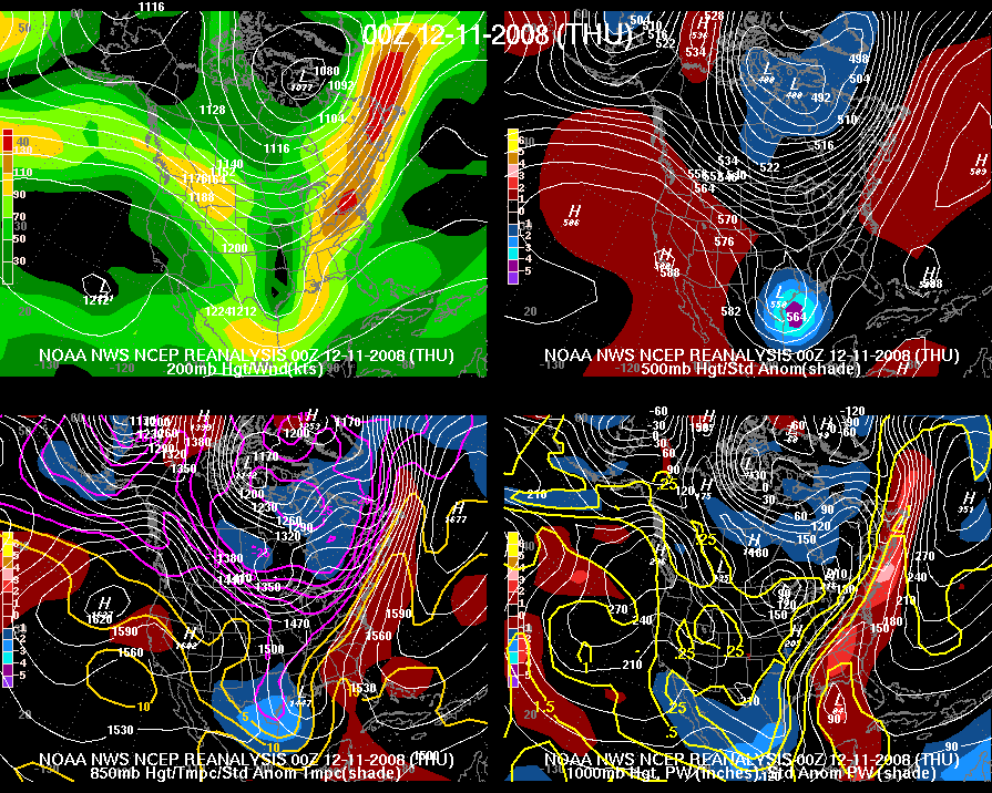
Another time a cold core low created mischief in SE TX

1 likes
Personal Forecast Disclaimer:
The posts in this forum are NOT official forecast and should not be used as such. They are just the opinion of the poster and may or may not be backed by sound meteorological data. They are NOT endorsed by any professional institution or storm2k.org. For official information, please refer to the NHC and NWS products.
The posts in this forum are NOT official forecast and should not be used as such. They are just the opinion of the poster and may or may not be backed by sound meteorological data. They are NOT endorsed by any professional institution or storm2k.org. For official information, please refer to the NHC and NWS products.
-
bubba hotep

- S2K Supporter
- Posts: 6014
- Joined: Wed Dec 28, 2016 1:00 am
- Location: Collin County Texas
Re: Texas Fall 2018
Pete Delkus trying to keep hope alive "dusting for DFW"
PANIC MODE! Heavy snow in the panhandle - cold rain for NTX. Plan on slowdowns for the Monday AM commute. As colder air works in, a little snow mix in with the rain! Areas from DFW to the northwest could get a dusting on grassy surfaces. Here's the timeline: #wfaaweather
1 likes
Winter time post are almost exclusively focused on the DFW area.
-
Captmorg70
- Tropical Storm

- Posts: 206
- Age: 38
- Joined: Mon Dec 18, 2017 12:07 am
- Location: Highland Village Tx
Re: Texas Fall 2018
bubba hotep wrote:Pete Delkus trying to keep hope alive "dusting for DFW"PANIC MODE! Heavy snow in the panhandle - cold rain for NTX. Plan on slowdowns for the Monday AM commute. As colder air works in, a little snow mix in with the rain! Areas from DFW to the northwest could get a dusting on grassy surfaces. Here's the timeline: #wfaaweather
What do you think it would take for a “dusting” to occur? Maybe there is an ingredient that overperforms, but this just doesn’t seem like a great setup for us in NTX
1 likes
Location - Highland Village
-
Brent
- S2K Supporter
- Posts: 38740
- Age: 37
- Joined: Sun May 16, 2004 10:30 pm
- Location: Tulsa Oklahoma
- Contact:
Re: Texas Fall 2018
bubba hotep wrote:Pete Delkus trying to keep hope alive "dusting for DFW"PANIC MODE! Heavy snow in the panhandle - cold rain for NTX. Plan on slowdowns for the Monday AM commute. As colder air works in, a little snow mix in with the rain! Areas from DFW to the northwest could get a dusting on grassy surfaces. Here's the timeline: #wfaaweather
Ah the eternal snow optimist lol. I'd be surprised if its more than a few flakes mixed in tbh
3 likes
#neversummer
-
Brent
- S2K Supporter
- Posts: 38740
- Age: 37
- Joined: Sun May 16, 2004 10:30 pm
- Location: Tulsa Oklahoma
- Contact:
Re: Texas Fall 2018
We Dallas people that cant buy a snowstorm need to move to the Panhandle lol
1 likes
#neversummer
-
bubba hotep
- S2K Supporter
- Posts: 6014
- Joined: Wed Dec 28, 2016 1:00 am
- Location: Collin County Texas
Re: Texas Fall 2018
Brent wrote:We Dallas people that cant buy a snowstorm need to move to the Panhandle lol
Pic from Dumas, TX

3 likes
Winter time post are almost exclusively focused on the DFW area.
-
Captmorg70
- Tropical Storm
- Posts: 206
- Age: 38
- Joined: Mon Dec 18, 2017 12:07 am
- Location: Highland Village Tx
Re: Texas Fall 2018
Even though I know the chances is very small tomorrow, probably will be staring at the radar and HRRR until it’s obvious that nothing is going to happen. 
3 likes
Location - Highland Village
-
Brent
- S2K Supporter
- Posts: 38740
- Age: 37
- Joined: Sun May 16, 2004 10:30 pm
- Location: Tulsa Oklahoma
- Contact:
Re: Texas Fall 2018
bubba hotep wrote:Brent wrote:We Dallas people that cant buy a snowstorm need to move to the Panhandle lol
Pic from Dumas, TX
https://pbs.twimg.com/media/DrxVoCUUcAAliQh.jpg
Nice
I just keep telling myself some day that'll be us again lol
0 likes
#neversummer
-
Brent
- S2K Supporter
- Posts: 38740
- Age: 37
- Joined: Sun May 16, 2004 10:30 pm
- Location: Tulsa Oklahoma
- Contact:
Re: Texas Fall 2018
The 0z CMC continues to look interesting Wednesday especially from Dallas and points east  Eventually one of these storms is gonna actually verify

Eventually one of these storms is gonna actually verify
1 likes
#neversummer

Re: Texas Fall 2018
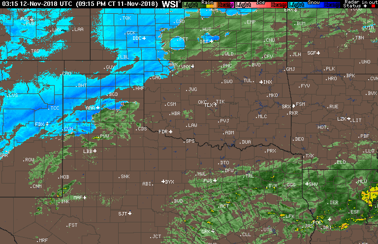
Brent wrote:The 0z CMC continues to look interesting Wednesday especially from Dallas and points east
http://i63.tinypic.com/2hphv5x.png
The NAM hints at the cold core too but doesn’t seem to support it with any precip.
0 likes
Graduate Meteorology Student at the University of Oklahoma!
All opinions independent of employers and the university.
All opinions independent of employers and the university.


Re: Texas Fall 2018
At this point you are rooting for the early closed low solution. If there is enough lift may see some snow yet with cold temperatures. Though might not be much, it is a better solution than the open positive tilt trough.
Hoping for a sneaky surprise.
Hoping for a sneaky surprise.
2 likes
The above post and any post by Ntxw is NOT an official forecast and should not be used as such. It is just the opinion of the poster and may or may not be backed by sound meteorological data. It is NOT endorsed by any professional institution including Storm2k. For official information, please refer to NWS products.
Help support Storm2K!
Re: Texas Fall 2018
Thundersnow with white out conditions currently in the Panhandle. Oh what could have been but glad for them as they were also in a snow/precip drought last year.
https://twitter.com/NWSAmarillo/status/1061839209567318018
https://twitter.com/NWSAmarillo/status/1061839209567318018
3 likes
The above post and any post by Ntxw is NOT an official forecast and should not be used as such. It is just the opinion of the poster and may or may not be backed by sound meteorological data. It is NOT endorsed by any professional institution including Storm2k. For official information, please refer to NWS products.
Help support Storm2K!
Help support Storm2K!
Re: Texas Fall 2018
Ntxw wrote:At this point you are rooting for the early closed low solution. If there is enough lift may see some snow yet with cold temperatures. Though might not be much, it is a better solution than the open positive tilt trough.
Hoping for a sneaky surprise.
Even though it’s highly improbable, there are some EPS members showing half a foot of snow for DFW with the Thursday possibilities. I definitely will be rooting for whichever solution gives us the highest amount of snow, but the last 3 years have taught me to expect nothing.
1 likes
Graduate Meteorology Student at the University of Oklahoma!
All opinions independent of employers and the university.
All opinions independent of employers and the university.
Re: Texas Fall 2018
Cerlin wrote:Ntxw wrote:At this point you are rooting for the early closed low solution. If there is enough lift may see some snow yet with cold temperatures. Though might not be much, it is a better solution than the open positive tilt trough.
Hoping for a sneaky surprise.
Even though it’s highly improbable, there are some EPS members showing half a foot of snow for DFW with the Thursday possibilities. I definitely will be rooting for whichever solution gives us the highest amount of snow, but the last 3 years have taught me to expect nothing.
You never know with the closed core lows. It will be plenty cold enough aloft and at the surface. If it can find moisture and pull it back or generate enough lift to beat the models it would be an early Christmas gift! That sounds about right expect nothing and hope for something!
2 likes
The above post and any post by Ntxw is NOT an official forecast and should not be used as such. It is just the opinion of the poster and may or may not be backed by sound meteorological data. It is NOT endorsed by any professional institution including Storm2k. For official information, please refer to NWS products.
Help support Storm2K!
Help support Storm2K!
-
hamburgerman7070
- Category 1

- Posts: 253
- Joined: Sat Dec 02, 2017 7:39 pm
- Location: Jonesboro ar
Re: Texas Fall 2018
Ntxw, do you think it's a matter of time before the right setup happens for a more realistic event for a little further south than where it is now?
0 likes
-
Brent
- S2K Supporter
- Posts: 38740
- Age: 37
- Joined: Sun May 16, 2004 10:30 pm
- Location: Tulsa Oklahoma
- Contact:
Re: Texas Fall 2018
Cerlin wrote:Ntxw wrote:At this point you are rooting for the early closed low solution. If there is enough lift may see some snow yet with cold temperatures. Though might not be much, it is a better solution than the open positive tilt trough.
Hoping for a sneaky surprise.
Even though it’s highly improbable, there are some EPS members showing half a foot of snow for DFW with the Thursday possibilities. I definitely will be rooting for whichever solution gives us the highest amount of snow, but the last 3 years have taught me to expect nothing.

Yeah i have to agree I'm still not over last winter or the years before
I know our time is coming but its just like when lol
I guess just the fact we're getting another possibility this week is amazing in itself
1 likes
#neversummer
Re: Texas Fall 2018
hamburgerman7070 wrote:Ntxw, do you think it's a matter of time before the right setup happens for a more realistic event for a little further south than where it is now?
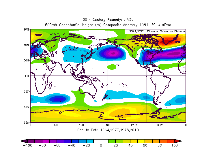
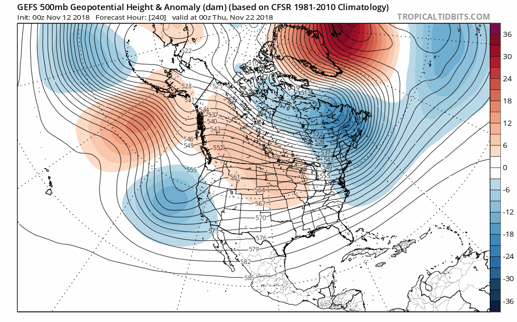
I really like our chances. I am seeing signs from the ensembles of a classic weak-mod Nino -NAOish set up going in the Atlantic after some retrogression of the monster European Ridge. The negative trough anomaly should extend from the Atlantic back to Texas with west coast or Aleutian trough undercutting it. I think we'll see a period coming here similar to events that occurred in 1963-1964, 1976-1977, 1977-1978 and 2009-2010 at 500mb. At some point we're going to get there, I can't say for sure on individual storms and timing, but for sure we may have more than one needle in the haystack. There will be a parade of southern STJ riding systems.
It won't be long though after Thanksgiving that we will be likely talking about the threat of a winter storm, in my opinion.
3 likes
The above post and any post by Ntxw is NOT an official forecast and should not be used as such. It is just the opinion of the poster and may or may not be backed by sound meteorological data. It is NOT endorsed by any professional institution including Storm2k. For official information, please refer to NWS products.
Help support Storm2K!
Help support Storm2K!
Re: Texas Fall 2018
Also lost in translation is the colder air. DFW is now -3.8F for the month so far. One freeze down and the forecast has 3 more. Hard freezes Tomorrow night, Tuesday morning, and a light one Wednesday morning for a total of 4 for the first half of the month. There is no anomalous torch in sight so we're going to keep this negative departure at least into week 3 of November. Far cry from the 90s one year ago.
No freezes were recorded at the airport in November 2015, 2016, or 2017.
No freezes were recorded at the airport in November 2015, 2016, or 2017.
1 likes
The above post and any post by Ntxw is NOT an official forecast and should not be used as such. It is just the opinion of the poster and may or may not be backed by sound meteorological data. It is NOT endorsed by any professional institution including Storm2k. For official information, please refer to NWS products.
Help support Storm2K!
Help support Storm2K!
Return to “USA & Caribbean Weather”
Who is online
Users browsing this forum: wxman22 and 32 guests