Texas Spring 2019
Moderator: S2k Moderators
Forum rules

The posts in this forum are NOT official forecast and should not be used as such. They are just the opinion of the poster and may or may not be backed by sound meteorological data. They are NOT endorsed by any professional institution or STORM2K.
Re: Texas Spring 2019
Stay safe up there Yukon. Keep us updated if you are not running for cover.
0 likes
-
Yukon Cornelius
- S2K Supporter

- Posts: 1842
- Age: 42
- Joined: Thu Dec 20, 2012 9:23 pm
- Location: Dean, TX/Westcliffe, CO
Re: Texas Spring 2019
gpsnowman wrote:Stay safe up there Yukon. Keep us updated if you are not running for cover.
Thanks. All of us are kind of “on the edge” today. There’s just a really weird feeling in the air. I was talking to a state trooper a little while ago and supposedly Oklahoma has closed the whole state including schools for today with the I guess rare high risk being issued.
0 likes
#neversummer
-
ThunderSleetDreams

- S2K Supporter
- Posts: 1510
- Age: 43
- Joined: Tue Dec 20, 2011 4:42 pm
- Location: S of Weimar, TX
Re: Texas Spring 2019
Stay safe my #NeverSummer brother!
0 likes
#NeverSummer
I hibernate when it gets above 75 degrees!
I hibernate when it gets above 75 degrees!
-
rwfromkansas
- Category 5

- Posts: 3038
- Joined: Sat Aug 27, 2005 12:47 am
- Location: North Fort Worth
-
Yukon Cornelius
- S2K Supporter
- Posts: 1842
- Age: 42
- Joined: Thu Dec 20, 2012 9:23 pm
- Location: Dean, TX/Westcliffe, CO
Re: Texas Spring 2019
ThunderSleetDreams wrote:
Stay safe my #NeverSummer brother!
<3 will do! Thanks. #neversummer
0 likes
#neversummer
-
rwfromkansas
- Category 5
- Posts: 3038
- Joined: Sat Aug 27, 2005 12:47 am
- Location: North Fort Worth
Re: Texas Spring 2019
Holy cow, check out the new outlook just released. EVEN BIGGER high risk and slight nudged now over Dallas county instead of just Tarrant.
1 likes
-
Yukon Cornelius
- S2K Supporter
- Posts: 1842
- Age: 42
- Joined: Thu Dec 20, 2012 9:23 pm
- Location: Dean, TX/Westcliffe, CO
-
WacoWx
- Category 2

- Posts: 692
- Joined: Mon Dec 28, 2009 4:14 pm
- Location: NOT Waco, TX ----> Dallas, TX
Re: Texas Spring 2019
It sounds dumb, but if you have a bike/snowboarding helmet keep it handy today.
1 likes
-
ThunderSleetDreams
- S2K Supporter
- Posts: 1510
- Age: 43
- Joined: Tue Dec 20, 2011 4:42 pm
- Location: S of Weimar, TX
Re: Texas Spring 2019
WacoWx wrote:It sounds dumb, but if you have a bike/snowboarding helmet keep it handy today.
And if you don't... a cooking pot.
2 likes
#NeverSummer
I hibernate when it gets above 75 degrees!
I hibernate when it gets above 75 degrees!
-
CaptinCrunch

- S2K Supporter
- Posts: 8780
- Age: 58
- Joined: Mon Nov 03, 2003 4:33 pm
- Location: Kennedale, TX (Tarrant Co.)
Re: Texas Spring 2019
110AM: We now have an extremely rare Level 5 risk of severe weather for later today and tonight. That high risk is as high as the scale goes. An outbreak of tornadoes is increasingly likely across the eastern Texas Panhandle, West Texas, Northwest Texas, and into the Big Country. This will include the threat for EF2-EF5 tornadoes that track for long-distances. Giant hail and destructive straight-line winds are also expected. This is an extremely dangerous and life-threatening situation. Ensure you have a safety plan ready. We've got safety tips at texasstormchasers.com/safety - and our free HD interactive weather radar at texasstormchasers.com/radar
0 likes
-
Lagreeneyes03
- Category 2
- Posts: 610
- Joined: Mon Dec 09, 2013 10:53 am
- Location: Luxurious Lake Grapevine
Re: Texas Spring 2019
rwfromkansas wrote:Holy cow, check out the new outlook just released. EVEN BIGGER high risk and slight nudged now over Dallas county instead of just Tarrant.
What are the chances of that moving even further east? It kind of seems like DFW has some kind of atmospherical conditon that's preventing super severe storms. they all seem to be the the West/reforming East and North/South of us.
Last edited by Lagreeneyes03 on Mon May 20, 2019 10:18 am, edited 1 time in total.
0 likes
I'm a Princess, not a forecaster.
-
AubreyStorm

- Category 1

- Posts: 337
- Age: 45
- Joined: Fri Jun 16, 2017 6:21 pm
- Location: Texas, USA
Re: Texas Spring 2019
WOWWW! 

1 likes
The posts are NOT an official forecast. Please REFER to the NHC and NWS for official forecasts and products.
-
bubba hotep

- S2K Supporter
- Posts: 6014
- Joined: Wed Dec 28, 2016 1:00 am
- Location: Collin County Texas
Re: Texas Spring 2019
Ellsey wrote:It looks like DFW is playing watch the cap game today.
5% Tor for DFW from.SPC which would typically be note worthy but not today. DFW is firmly within the open warm sector and any WAA storm could go off but coverage should be low and predictability even lower. Highly conditional threat that probably won't produce anything but watch out if a loaner cell gets rooted and establishes an updraft.
0 likes
Winter time post are almost exclusively focused on the DFW area.

Re: Texas Spring 2019
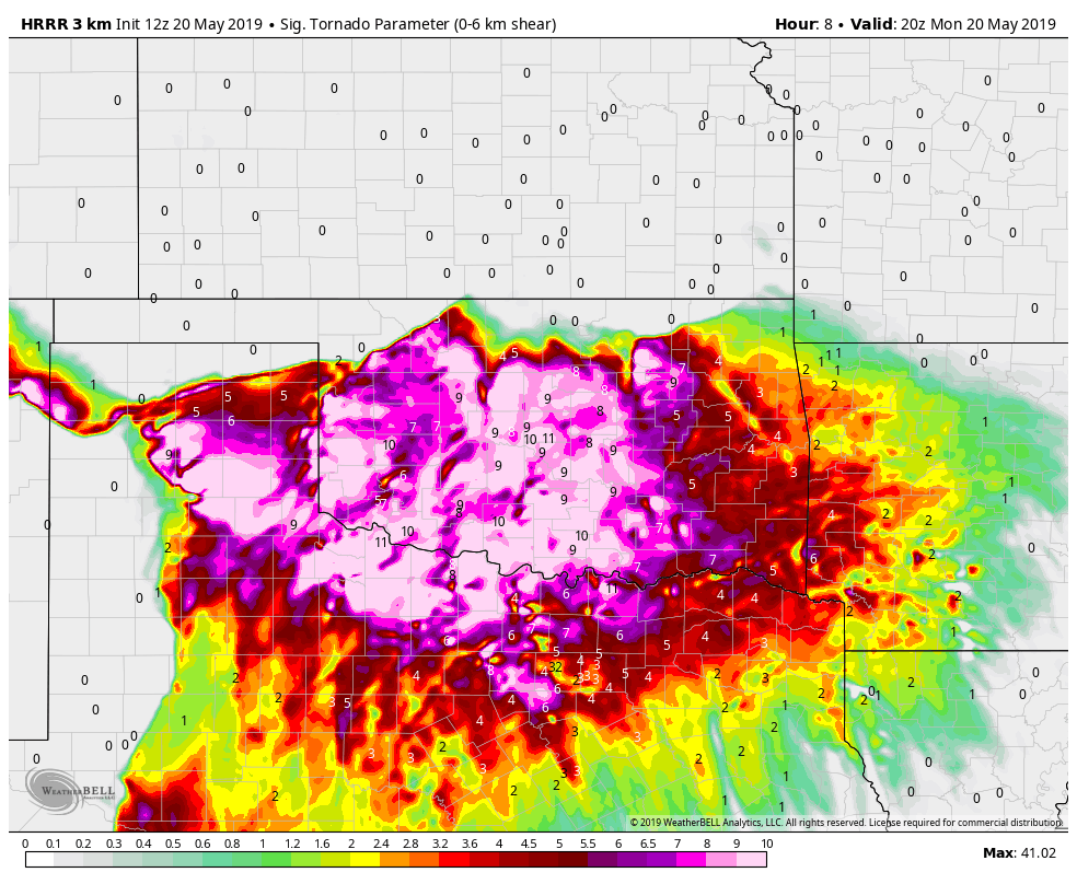
STP is up to 11 across parts of OK and NW TX, that's seriously insane. Even the STP of 3-7 over DFW is crazy
https://pbs.twimg.com/media/D7A8YioXoAECa6d.png
https://pbs.twimg.com/media/D7A8YioXoAECa6d.png
0 likes
-
Texas Snowman

- Storm2k Moderator

- Posts: 6197
- Joined: Fri Jan 25, 2008 11:29 am
- Location: Denison, Texas
Re: Texas Spring 2019
0 likes
The above post and any post by Texas Snowman is NOT an official forecast and should not be used as such. It is just the opinion of the poster and may or may not be backed by sound meteorological data. It is NOT endorsed by any professional institution including storm2k.org. For official information, please refer to NWS products.

Re: Texas Spring 2019
Lagreeneyes03 wrote:rwfromkansas wrote:Holy cow, check out the new outlook just released. EVEN BIGGER high risk and slight nudged now over Dallas county instead of just Tarrant.
What are the chances of that moving even further east? It kind of seems like DFW has some kind of atmospherical conditon that's preventing super severe storms. they all seem to be the the West/reforming East and North/South of us.
For DFW it is the same game as before. IF lone cells pop then they will quickly be severe. As for the main event timing is storms fire over NW Texas and line up as they reach DFW overnight or early morning. It has been timing that so far has prevented bigger things in the metroplex.
In the past the ideal timing is when cells fire over the western counties or overhead before congealing. Storms are often at their most powerful when they initiate and don't have to compete with other storms.
0 likes
The above post and any post by Ntxw is NOT an official forecast and should not be used as such. It is just the opinion of the poster and may or may not be backed by sound meteorological data. It is NOT endorsed by any professional institution including Storm2k. For official information, please refer to NWS products.
Help support Storm2K!
-
TheProfessor

- Professional-Met

- Posts: 3506
- Age: 29
- Joined: Tue Dec 03, 2013 10:56 am
- Location: Wichita, Kansas
Re: Texas Spring 2019
SPC’s MCD would suggest a PDS watch for parts of the panhandle
0 likes
An alumnus of The Ohio State University.
Your local National Weather Service office is your best source for weather information.
Your local National Weather Service office is your best source for weather information.

Re: Texas Spring 2019
Forecast HRRR sounding near OKC at 22Z - wow

0 likes
The above post and any post by dhweather is NOT an official forecast and should not be used as such. It is just the opinion of the poster and may or may not be backed by sound meteorological data. It is NOT endorsed by any professional institution including storm2k.org. For official information, please refer to NWS products.
-
Tireman4

- S2K Supporter
- Posts: 5903
- Age: 60
- Joined: Fri Jun 30, 2006 1:08 pm
- Location: Humble, Texas
- Contact:
Re: Texas Spring 2019
This is gonna be an interesting day and into the night for this area...
FXUS64 KOUN 201146
AFDOUN
Area Forecast Discussion
National Weather Service Norman OK
646 AM CDT Mon May 20 2019
.DISCUSSION...
The 12Z aviation discussion follows....
&&
.AVIATION...
A warm front over Texas will move north today, probably to near
I-40 around 18Z, to somewhere between I-40 and the OK/KS border
by 00Z. Its position will be influenced significantly by the
evolution of thunderstorms this morning and afternoon, as well as
the extraordinarily strong parent storm system. Numerous
thunderstorms are expected to develop this morning through tonight
over the forecast area, and many of them are expected to be
severe. The TAFs have highlighted with TEMPOs and PROB30s the
expected hours of greatest impact from thunderstorms (though with
relatively low confidence in timing). Most terminals will have
thunderstorms nearby for most of the period after 15Z or so.
Storms should end from west to east between 06Z and about 15Z
tomorrow morning (except storms in northwest Oklahoma may persist
longer than the storms farther south).
CmS
&&
.PREV DISCUSSION... /issued 319 AM CDT Mon May 20 2019/
DISCUSSION...
Widespread and high end severe weather is still expected today
over most of Oklahoma and adjacent parts of northern Texas. The
first wave of at least two today was producing thunderstorms early
this morning in the western TX panhandle. These will continue to
develop east and interact with a diffuse warm front that will
drift north into central Oklahoma later this morning. Very high
instability and very strong vertical shear will persist across
the area today while a second round of supercells are expected
over the TX panhandle that will move east into Oklahoma later this
afternoon and overnight. Very large hail, strong tornadoes and
damaging winds are all expected aided by a strong low-level jet.
Additionally, very heavy rainfall is expected to cause flooding,
particularly from southwest into central and north central
Oklahoma with the several rounds of thunderstorms. The large-
scale wave will exit to the east Tuesday morning after which a
brief period of quiet weather returns. However, another strong
trough moves into the southwestern U.S. Wednesday while lower
layer moisture moves north over the southern plains. Rain and
thunderstorm chances begin Wednesday and last into the weekend.
The focus may be more across the northwestern half of Oklahoma as
a strong upper ridge may limit coverage farther southeast.
&&
.PRELIMINARY POINT TEMPS/POPS...
Oklahoma City OK 76 63 75 59 / 60 80 50 0
Hobart OK 77 60 75 56 / 70 80 10 0
Wichita Falls TX 83 64 78 61 / 60 80 30 0
Gage OK 65 56 74 51 / 80 80 10 0
Ponca City OK 67 64 74 59 / 90 90 60 0
Durant OK 82 65 77 62 / 60 40 80 0
&&
.OUN WATCHES/WARNINGS/ADVISORIES...
OK...Flood Watch through Tuesday afternoon for OKZ004>048-050>052.
TX...Flood Watch through Tuesday afternoon for TXZ083>090.
&&
$$
23/09/23
0 likes
Return to “USA & Caribbean Weather”
Who is online
Users browsing this forum: wxman22 and 133 guests