Texas Spring-2014

U.S. & Caribbean Weather Discussions and Severe Weather Events

Moderator: S2k Moderators

Forum rules

The posts in this forum are NOT official forecast and should not be used as such. They are just the opinion of the poster and may or may not be backed by sound meteorological data. They are NOT endorsed by any professional institution or STORM2K.

Help Support Storm2K
Message
Author
User avatar
dhweather
S2K Supporter
S2K Supporter
Posts: 6199
Joined: Sat Aug 14, 2004 9:29 pm
Location: Heath, TX
Contact:

Re:

#161 Postby dhweather » Tue Apr 01, 2014 3:30 pm

Ntxw wrote:I'm not sold yet on severe weather outbreak this week. CIN (better known as the cap) seems a little strong for numerous initiation. Arklatex vicinity looks better and definitely Louisiana and Arkansas. The bigger story will be later in the week with a slow moving rainmaker. 1-3 inches of rain is possible for Northern, Central, SE Texas. Don't think it will be a big severe weather maker either, associated with low heights and anomalous cooler air. Of course in time for final four weekend at Jerryworld.


I too have serious doubts about a major severe weather outbreak. The low will be moving NE away from us, so we're basically counting almost solely on the dryline to initiate thunderstorms. And yes, our dear friend the cap will take more than a dryline to get rid of it.
0 likes   
The above post and any post by dhweather is NOT an official forecast and should not be used as such. It is just the opinion of the poster and may or may not be backed by sound meteorological data. It is NOT endorsed by any professional institution including storm2k.org. For official information, please refer to NWS products.

User avatar
dhweather
S2K Supporter
S2K Supporter
Posts: 6199
Joined: Sat Aug 14, 2004 9:29 pm
Location: Heath, TX
Contact:

Re: Texas Spring-2014

#162 Postby dhweather » Tue Apr 01, 2014 3:42 pm

Image


MESOSCALE DISCUSSION 0241
NWS STORM PREDICTION CENTER NORMAN OK
0334 PM CDT TUE APR 01 2014

AREAS AFFECTED...WESTERN NORTH TX/SOUTHERN OK

CONCERNING...SEVERE POTENTIAL...WATCH POSSIBLE

VALID 012034Z - 012230Z

PROBABILITY OF WATCH ISSUANCE...60 PERCENT

SUMMARY...MONITORING FOR TSTM DEVELOPMENT AND ASSOCIATED INCREASING
SEVERE TSTM POTENTIAL THROUGH LATE AFTERNOON/EARLY EVENING ACROSS
THE WESTERN PARTS OF NORTH TX INTO SOUTHERN OK. INCREASING SIGNS OF
DEEP CONVECTIVE DEVELOPMENT COULD PROMPT A WATCH ISSUANCE.

DISCUSSION...TIED TO A SURFACE LOW ACROSS SOUTHWEST TX/TX SOUTH
PLAINS...A FRONTAL BOUNDARY LAYER ANGLES SOUTHWEST-NORTHEASTWARD
ACROSS THE LOW ROLLING PLAINS AND WESTERN PART OF NORTH TX INTO
SOUTHERN/EAST-CENTRAL OK. NEAR THE BOUNDARY...SOME DEEPENING OF THE
CU FIELD HAS BEEN NOTED IN VISIBLE SATELLITE IMAGERY IN THE GENERAL
VICINITY OF THE RED RIVER...AND PERHAPS AS FAR SOUTHWEST AS THE
ABILENE/SAN ANGELO AREAS UNDER OVERSPREADING CIRRUS...AS OF
MID-AFTERNOON.

WHILE OVERALL CONVERGENCE/FORCING FOR ASCENT IS MODEST...THE
BOUNDARY LAYER CONTINUES TO STEADILY DESTABILIZE...WITH INCREASINGLY
NEGLIGIBLE CINH ESPECIALLY WHERE SURFACE TEMPERATURES HAVE EXCEEDED
APPROX 83F. WHILE THE LIKELIHOOD/EXTENT OF DEEP CONVECTIVE
DEVELOPMENT REMAINS UNCERTAIN EVEN IN THE SHORT-TERM...INCREASING
CONFIDENCE/IMMINENT SIGNS OF SUCH DEVELOPMENT WOULD LIKELY PROMPT A
WATCH ISSUANCE. GIVEN MODEST INSTABILITY...WINDS
VEERING/STRENGTHENING WITH HEIGHT AND 40+ KT OF EFFECTIVE SHEAR
WOULD SUPPORT THE POTENTIAL FOR SUPERCELLS CAPABLE OF MAINLY LARGE
HAIL.

..GUYER/HART.. 04/01/2014
0 likes   
The above post and any post by dhweather is NOT an official forecast and should not be used as such. It is just the opinion of the poster and may or may not be backed by sound meteorological data. It is NOT endorsed by any professional institution including storm2k.org. For official information, please refer to NWS products.

TarrantWx
Category 1
Category 1
Posts: 287
Age: 39
Joined: Thu Jan 30, 2014 10:38 am
Location: Keller, TX

#163 Postby TarrantWx » Tue Apr 01, 2014 6:04 pm

An isolated storm just formed north of Abilene around Haskell. Looks to be intensifying quickly, expect a warning on it soon. Echo tops already up to 46K according to GR3. Looks to be some mid-level rotation also. Expect this to take on supercellular characteristics pretty quickly. Watch for it to split a little later. HRRR was indicating this very storm most of the day forming in this area and splitting. HRRR showed the right-mover moving due east just south of the river. Hope someone is out there getting pictures of this thing. It's in an ideal chasing area. Should be a fun evening of radar watching.

Edit: Svr Tstm warning issued for Haskell & Throckmorton
0 likes   

TarrantWx
Category 1
Category 1
Posts: 287
Age: 39
Joined: Thu Jan 30, 2014 10:38 am
Location: Keller, TX

#164 Postby TarrantWx » Tue Apr 01, 2014 7:37 pm

Tornado warning for Throckmorton county. Really nice hook developing on the supercell in southern Throckmorton. It's also right-moving and has turned east. HRRR looks to have done an amazing job with this one
0 likes   

User avatar
South Texas Storms
Professional-Met
Professional-Met
Posts: 4201
Joined: Thu Jun 24, 2010 12:28 am
Location: Houston, TX

Re: Texas Spring-2014

#165 Postby South Texas Storms » Tue Apr 01, 2014 8:01 pm

Ntxw, do you still think heavier rain will return towards the end of this month? The CFSv2 is indicating that a large part of April will be wet. I really hope so.
0 likes   

User avatar
Ntxw
Storm2k Moderator
Storm2k Moderator
Posts: 22731
Joined: Wed Oct 21, 2009 6:34 pm
Location: DFW, Texas

Re: Texas Spring-2014

#166 Postby Ntxw » Tue Apr 01, 2014 8:07 pm

South Texas Storms wrote:Ntxw, do you still think heavier rain will return towards the end of this month? The CFSv2 is indicating that a large part of April will be wet. I really hope so.


Sorry I missed the question earlier, yes! Stated last month I believed the second half of April will arise a new pattern regime of wet for us for a long time ENSO related. CFSv2 and other agencies are coming to a consensus that El Nino conditions (essentially El Nino) will be in place by May. We will probably see the El Nino watch upgraded to El Nino warning sometime in one of the May or June updates IMO, no later than July. 2009 saw the warning come in July and that was much weaker and slower warming than now. The new MJO (WWB) is going to be the catalyst to click it all going.
0 likes   
The above post and any post by Ntxw is NOT an official forecast and should not be used as such. It is just the opinion of the poster and may or may not be backed by sound meteorological data. It is NOT endorsed by any professional institution including Storm2k. For official information, please refer to NWS products.

  Help support Storm2K!
Help Support Storm2K

User avatar
South Texas Storms
Professional-Met
Professional-Met
Posts: 4201
Joined: Thu Jun 24, 2010 12:28 am
Location: Houston, TX

Re: Texas Spring-2014

#167 Postby South Texas Storms » Tue Apr 01, 2014 8:19 pm

Ntxw wrote:
South Texas Storms wrote:Ntxw, do you still think heavier rain will return towards the end of this month? The CFSv2 is indicating that a large part of April will be wet. I really hope so.


Sorry I missed the question earlier, yes! Stated last month I believed the second half of April will arise a new pattern regime of wet for us for a long time ENSO related. CFSv2 and other agencies are coming to a consensus that El Nino conditions (essentially El Nino) will be in place by May. We will probably see the El Nino watch upgraded to El Nino warning sometime in one of the May or June updates IMO, no later than July. 2009 saw the warning come in July and that was much weaker and slower warming than now. The new MJO (WWB) is going to be the catalyst to click it all going.


Thanks for answering! Yeah I remember you saying last month that a wet weather pattern would begin in the second half of April and now the models are starting to agree with you. Will the possible developing tropical cyclone currently in the WPAC help to cause the WWB in the ENSO regions or will this happen a little later this month?
0 likes   

User avatar
Ntxw
Storm2k Moderator
Storm2k Moderator
Posts: 22731
Joined: Wed Oct 21, 2009 6:34 pm
Location: DFW, Texas

Re: Texas Spring-2014

#168 Postby Ntxw » Tue Apr 01, 2014 8:27 pm

South Texas Storms wrote:Thanks for answering! Yeah I remember you saying last month that a wet weather pattern would begin in the second half of April and now the models are starting to agree with you. Will the possible developing tropical cyclone currently in the WPAC help to cause the WWB in the ENSO regions or will this happen a little later this month?


It's one of those chicken or egg things. Is the WWB causing the typhoon or the typhoon creating WWB? Probably both, feedback regardless of which did what each one enhances the other. I think there could be more than just one typhoon as the MJO progresses east eventually to the CPAC as well. It's good correlation for NA that when there is a typhoon, weather happens down the road.
0 likes   
The above post and any post by Ntxw is NOT an official forecast and should not be used as such. It is just the opinion of the poster and may or may not be backed by sound meteorological data. It is NOT endorsed by any professional institution including Storm2k. For official information, please refer to NWS products.


  Help support Storm2K!

Help Support Storm2K


User avatar
TheProfessor
Professional-Met
Professional-Met
Posts: 3506
Age: 28
Joined: Tue Dec 03, 2013 10:56 am
Location: Wichita, Kansas

#169 Postby TheProfessor » Tue Apr 01, 2014 8:48 pm

Could a thunderstorm erode a cap? If so could this storm out cause trouble to DFW tomorrow if it makes it to the metroplex tonight?
0 likes   
An alumnus of The Ohio State University.

Your local National Weather Service office is your best source for weather information.

TarrantWx
Category 1
Category 1
Posts: 287
Age: 39
Joined: Thu Jan 30, 2014 10:38 am
Location: Keller, TX

Re:

#170 Postby TarrantWx » Tue Apr 01, 2014 8:59 pm

TheProfessor wrote:Could a thunderstorm erode a cap? If so could this storm out cause trouble to DFW tomorrow if it makes it to the metroplex tonight?


I don't think this storm will have any effect on the cap for tomorrow. The thing to keep an eye on regarding the strength of the cap tomorrow is the amount of sunshine. The more warming, the weaker the cap. The thing to watch out for as a result of this particular storm, if anything, would be the potential for leftover outflow boundaries tomorrow. You would likely be able to detect these on visible satellite in the morning and possibly on radar if they're distinct enough. An outflow boundary can act like a front in the mesoscale environment, so if a storm develops and rides an outflow boundary it will have locally higher helicity to work with possibly enhancing the tornado threat. By no means am I saying that this will happen, just merely explaining what could happen it one is leftover tomorrow
0 likes   

User avatar
TheProfessor
Professional-Met
Professional-Met
Posts: 3506
Age: 28
Joined: Tue Dec 03, 2013 10:56 am
Location: Wichita, Kansas

Re: Re:

#171 Postby TheProfessor » Tue Apr 01, 2014 9:05 pm

TarrantWx wrote:
TheProfessor wrote:Could a thunderstorm erode a cap? If so could this storm out cause trouble to DFW tomorrow if it makes it to the metroplex tonight?


I don't think this storm will have any effect on the cap for tomorrow. The thing to keep an eye on regarding the strength of the cap tomorrow is the amount of sunshine. The more warming, the weaker the cap. The thing to watch out for as a result of this particular storm, if anything, would be the potential for leftover outflow boundaries tomorrow. You would likely be able to detect these on visible satellite in the morning and possibly on radar if they're distinct enough. An outflow boundary can act like a front in the mesoscale environment, so if a storm develops and rides an outflow boundary it will have locally higher helicity to work with possibly enhancing the tornado threat. By no means am I saying that this will happen, just merely explaining what could happen it one is leftover tomorrow


Yeah I read a report that it was an outflow boundary that helped intensify the 1997 Central Texas mini outbreak, which is well known because of the Jarrell Texas F-5 Tornado.
0 likes   
An alumnus of The Ohio State University.

Your local National Weather Service office is your best source for weather information.

User avatar
TheProfessor
Professional-Met
Professional-Met
Posts: 3506
Age: 28
Joined: Tue Dec 03, 2013 10:56 am
Location: Wichita, Kansas

#172 Postby TheProfessor » Tue Apr 01, 2014 9:07 pm

By the way that storm is now dropping Tennis Ball size hail! :eek: I would not want to drive through the core of that storm.
0 likes   
An alumnus of The Ohio State University.

Your local National Weather Service office is your best source for weather information.

TarrantWx
Category 1
Category 1
Posts: 287
Age: 39
Joined: Thu Jan 30, 2014 10:38 am
Location: Keller, TX

#173 Postby TarrantWx » Tue Apr 01, 2014 9:18 pm

Earlier, HRRR indicated that this storm would dissipate well before it got to the metroplex, but this thing doesn't seem to be in a big hurry to weaken. I'm starting to wonder if it might make it into the northern DFW metro before dissipating. Even if it did get here, it wouldn't be at the same intensity level it is now, but it would be a nice little surprise.
0 likes   

User avatar
Ntxw
Storm2k Moderator
Storm2k Moderator
Posts: 22731
Joined: Wed Oct 21, 2009 6:34 pm
Location: DFW, Texas

Re: Re:

#174 Postby Ntxw » Tue Apr 01, 2014 9:42 pm

TheProfessor wrote:Yeah I read a report that it was an outflow boundary that helped intensify the 1997 Central Texas mini outbreak, which is well known because of the Jarrell Texas F-5 Tornado.


It was, very unusual the storm was moving southwest unlike just about every thunderstorm you know. It moved, and fed along the boundary that was in place.

Image

Cool loop of that infamous cell
0 likes   
The above post and any post by Ntxw is NOT an official forecast and should not be used as such. It is just the opinion of the poster and may or may not be backed by sound meteorological data. It is NOT endorsed by any professional institution including Storm2k. For official information, please refer to NWS products.


  Help support Storm2K!

Help Support Storm2K


User avatar
TheProfessor
Professional-Met
Professional-Met
Posts: 3506
Age: 28
Joined: Tue Dec 03, 2013 10:56 am
Location: Wichita, Kansas

#175 Postby TheProfessor » Wed Apr 02, 2014 8:46 am

:uarrow: IT might have been a good thing that it moved that direction. If it had moved northeast it could have hit a more populated area like Waco or the southern outskirts of Dallas.
0 likes   
An alumnus of The Ohio State University.

Your local National Weather Service office is your best source for weather information.

User avatar
Rgv20
S2K Supporter
S2K Supporter
Posts: 2466
Age: 38
Joined: Wed Jan 05, 2011 5:42 pm
Location: Edinburg/McAllen Tx

#176 Postby Rgv20 » Wed Apr 02, 2014 9:08 am

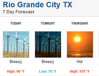
I come back from Denton to temps like this.....Summer! :sun:

Image
0 likes   
The following post is NOT an official forecast and should not be used as such. It is just the opinion of the poster and may or may not be backed by sound meteorological data. It is NOT endorsed by any professional institution including storm2k.org For Official Information please refer to the NHC and NWS products.

User avatar
dhweather
S2K Supporter
S2K Supporter
Posts: 6199
Joined: Sat Aug 14, 2004 9:29 pm
Location: Heath, TX
Contact:

Re:

#177 Postby dhweather » Wed Apr 02, 2014 10:53 am

TheProfessor wrote:Could a thunderstorm erode a cap? If so could this storm out cause trouble to DFW tomorrow if it makes it to the metroplex tonight?


Usually a thunderstorm, if it's really lucky, can punch through the cap and maintain itself. It's relatively small scale and doesn't really impact the overall cap. Thus when you see in AFD's "large scale forcing...." that's when something coming along is significant enough to erode the cap.
0 likes   
The above post and any post by dhweather is NOT an official forecast and should not be used as such. It is just the opinion of the poster and may or may not be backed by sound meteorological data. It is NOT endorsed by any professional institution including storm2k.org. For official information, please refer to NWS products.

User avatar
South Texas Storms
Professional-Met
Professional-Met
Posts: 4201
Joined: Thu Jun 24, 2010 12:28 am
Location: Houston, TX

Re: Texas Spring-2014

#178 Postby South Texas Storms » Wed Apr 02, 2014 11:29 am

What a surprise...the 12z GFS shows all of the 1+ inch rain totals falling just north and east of the TX border with this weekend's system. It's amazing how all of the heavy rain throughout the past several months seems to develop just outside of our state. This weather pattern sucks. Please bring us some rain El Nino!
0 likes   

User avatar
dhweather
S2K Supporter
S2K Supporter
Posts: 6199
Joined: Sat Aug 14, 2004 9:29 pm
Location: Heath, TX
Contact:

Re: Texas Spring-2014

#179 Postby dhweather » Wed Apr 02, 2014 11:58 am

South Texas Storms wrote:What a surprise...the 12z GFS shows all of the 1+ inch rain totals falling just north and east of the TX border with this weekend's system. It's amazing how all of the heavy rain throughout the past several months seems to develop just outside of our state. This weather pattern sucks. Please bring us some rain El Nino!


Shock and awe. :roll:

It's been that way forever. Red river counties and north, TX/LA border counties and east.
0 likes   
The above post and any post by dhweather is NOT an official forecast and should not be used as such. It is just the opinion of the poster and may or may not be backed by sound meteorological data. It is NOT endorsed by any professional institution including storm2k.org. For official information, please refer to NWS products.

User avatar
TheProfessor
Professional-Met
Professional-Met
Posts: 3506
Age: 28
Joined: Tue Dec 03, 2013 10:56 am
Location: Wichita, Kansas

#180 Postby TheProfessor » Wed Apr 02, 2014 1:51 pm

It looks like the RAP, GFS, and the Nam all have the cap weakening in the late afternoon. How accurate are these models when forecasting the strength of a cap?
0 likes   
An alumnus of The Ohio State University.

Your local National Weather Service office is your best source for weather information.


Return to “USA & Caribbean Weather”

Who is online

Users browsing this forum: Google [Bot] and 52 guests